Air law
- Airspaces
- Overview
- Airspace class A
- Airspace class B
- Airspace class C
- Airspace class D
- Control zone (D-CTR)
- Airspace class E
- Airspace class F
- Airspace class G
- Aerodrome Traffic Zone (ATZ)
- Transponder Mandatory Zone (TMZ)
- Radio Mandatory Zone (RMZ)
- Altimetry
- Flight plan
- Flight rule change
Airspaces
Overview
Airspace classes according to ICAO
What is airspace? A simple question at first glance, but how about the details? Legislation states that airspace is the area that extends upwards over a certain part of the earth's surface.
However, with more and more air traffic, it was no longer possible to simply categorize ‘airspace’ as being the same everywhere. Rules had become necessary.
To this end, the ICAO (International Civil Aviation Organisation) introduced airspace classes. The categorisation of an airspace class regulates, among other things, who is allowed to fly in this airspace, whether they need clearance to do so, how fast they are allowed to fly and much more. In our everyday lives, this can be roughly compared to the introduction of different types of roads. Let's take a motorway as an example and compare it with a local road: while there is no speed limit on the German motorway, you are only allowed a top speed of 50 km/h in urban areas. Alternatively, let's take a look at who is allowed to drive there: Anyone can drive in urban areas, including cyclists. However, bicycles are not allowed on the motorway.
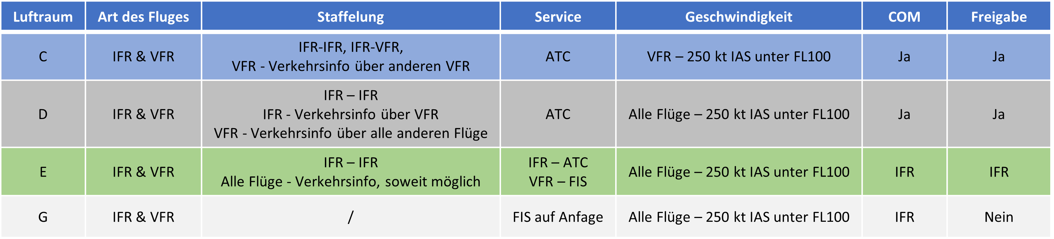
But now back from the road to the air: there are the airspace classes A, B, C, D, E, F and G. These in turn are divided into controlled airspaces (A-E), i.e. airspaces in which an IFR flight receives ATC service, and uncontrolled airspaces (F and G), in which there is only FIS and/or advisory service. A is the most restrictive airspace (for example, only IFR may fly here, VFR is absolutely prohibited), G is the least restricted airspace.
For the sake of simplicity, however, we will limit ourselves to the airspaces currently used in Germany, which are C, D, E and G. You can find an overview of these in the table below. For each air space class, the table shows whether and how different flight rules (VFR - visual flight rules and IFR - instrument flight rules) are separated from each other, what service the flight receives from air traffic control in this airspace, how fast it may fly, whether it must be in contact with a controller in this airspace (COM) and whether it requires an ATC clearance to enter this airspace.
You can find more information on airspaces on this link, although this is not mandatory for S1/S2 training.
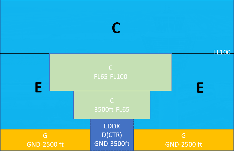
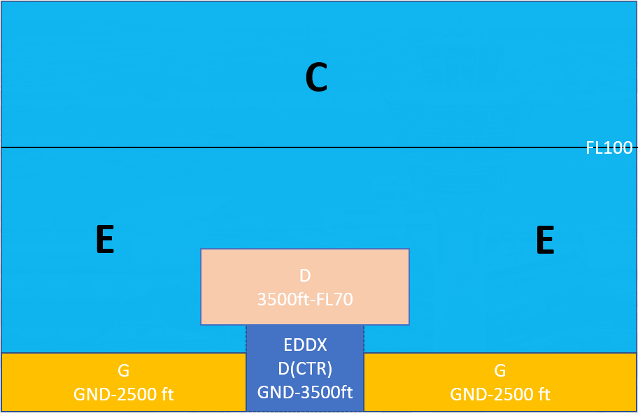
In the two pictures you can see an example of what airspace structure in Germany might look like. The top image shows a large airport such as Munich, while the bottom image shows a smaller airport such as Bremen.
Airspace class A
General
There are currently no class A airspaces in Germany. However, they are widespread in the rest of the world, e.g. in Australia, France, Italy, and Great Britain.
Airspace A is the most restrictive airspace of all, counts as controlled airspace and only permits IFR traffic. Let's take a look at the airspace rules.
Rules

VMC Minima
As in all other airspaces, the following minima apply:
- Flight visibility above FL100: 8 km
- Visibility below FL100: 5 km
- Horizontal distance from clouds: 1500 m
- Distance from clouds vertically: 1000 ft
The VMC minima only serve as a guideline for pilots and do not mean that VFR flights are accepted.
Weiterführende Links
Airspace class B
General
There are currently no class B airspaces in Germany. They are also not common in the rest of the world, but are typical in the USA. After airspace A, airspace B is the second most restrictive airspace in existence. Airspace B is controlled airspace.
The following rules apply in airspace B.
Rules

In contrast to class A airspace, VFR flights are permitted in Bravo airspace. However, these are separated from all other flights.
VMC Minima
As in all other airspaces, the following minima apply:
- Flight visibility above FL100: 8 km
- Visibility below FL100: 5 km
- Horizontal distance from clouds: 1500 m
- Distance from clouds vertically: 1000 ft
Further links
Airspace class C
General
In Germany, airspace above FL100 upwards (or FL130 upwards Alpine regions) generally is Class C airspace. This is not always labelled on the charts. Otherwise, Charlie is usually found in the local traffic control area of commercial airports above the control zone to separate VFR traffic from the generally fast, heavy, commercial IFR traffic when the traffic load in the airspace increases. Airspace C is controlled airspace.
Rules

In contrast to airspaces A and B, VFR flights have to independently separate from each other for the first time. We also have a speed limit for VFR traffic below FL100.
The EU stipulates that airspace class C must apply throughout Europe above FL195. However, as mentioned above, Germany is implementing this as low as FL100.
VMC Minima
As in all other airspaces, the following minima apply:
- Flight visibility above FL100: 8 km
- Visibility below FL100: 5 km
- Horizontal distance from clouds: 1500 m
- Distance from clouds vertically: 1000 ft
Further links
Airspace class D
General
In Germany, Delta is found in the local traffic control area of less frequented commercial airports in order to keep VFR apart traffic from the usually fast, heavy, commercial instrument flight traffic when the traffic load in the airspace increases. In addition, control zones in Germany are classified exclusively as delta airspace. Airspace D is controlled airspace.
Rules

VMC Minima
As in all other airspaces, the following minima apply:
-
Flight visibility above FL100: 8 km
-
Visibility below FL100: 5 km
-
Horizontal distance from clouds: 1500 m
-
Distance from clouds vertically: 1000 ft
Special minimums in D(CTR):
- Ground visibility: 5 km
- Ceiling: 1500 ft
Further links
Control zone (D-CTR)
A control zone (CTR) is the controlled airspace in the immediate vicinity of a commercial airport or larger aerodrome. The responsible authority is a tower, which in reality operates mainly by sight. The radar screen only serves as support.
The control zone has some special features compared to other controlled airspace:
- It always has the ground (GND) as its lower limit, whereas a control area (i.e. all other controlled airspace that is not defined as a control zone) never extends to the ground.
- SVFR (special flights under visual flight rules) is possible in a control zone in order to enable landings / departures at controlled airports even in bad weather under certain conditions.
- Additional VFR minima:
- Ground visibility: 5 km
- Ceiling: 1500 ft
Characteristics
In Germany, control zones are classified as delta airspace without exception. Therefore, all rules that apply in ‘normal’ delta airspace also apply in these zones. Depending on the volume of traffic, control zones can also be kept active only temporarily - either defined by the operating hours of the aerodrome (e.g. 06:00 - 20:00 locally) or activated when required (e.g. approaching IFR traffic). Such temporarily active airspaces can be recognised on charts by the suffix (HX) - e.g. D(HX). When inactive, the classification of the general airspace structure applies (see further links).
Control zones can be recognised on the German ICAO map by the reddish coloring of the area of responsibility.
While instrument flight traffic mainly flies published procedures (e.g. an ILS approach or a SID) in and out of the control zone, mandatory reporting points are usually used for VFR, regulating entries and exits. More details are defined in the Standard Operating Procedures of the respective aerodrome.
 Control zone Stuttgart - © openflightmaps.org
Further links
- Airspace structure and visual flught rules in Germany, Deutsche Flugsicherung GmbH
Airspace class E
General
In Germany, airspace E usually extends from 2500 ft GND to FL100, provided it is not interrupted by airspace C or D. In the Alps, the airspace is raised to FL130, and lowered in the vicinity of commercial airports. There are 3 different lower limits. These are color-coded on the 1:1 000 000 route maps.
- 1000 ft AGL - pink
- 1700 ft AGL - blue
- 2500 ft AGL - green

With the kind permission of DFS Deutsche Flugsicherung GmbH. Not to be used for navigational purposes!
Airspace E is controlled airspace.
Rules

Important: In contrast to the other controlled airspaces, VFR traffic neither needs an active radio communication with air traffic control nor clearance to enter the airspace.
VMC Minima
As in all other airspaces, the following minima apply:
- Flight visibility above FL100: 8 km
- Visibility below FL100: 5 km
- Horizontal distance from clouds: 1500 m
- Distance from clouds vertically: 1000 ft
Further links
Airspace class F
General
There are currently no class F airspaces in Germany, and neither are there in the rest of the world. Airspace F is uncontrolled airspace.
The Standardised European Rules of the Air (SERA) also state that airspace F is only to be regarded as a temporary measure until it can be replaced by airspace of another class.
The following rules apply in airspace F.
Rules

- ADVS = Advisory Service
- ALRS = Alerting Service
VMC Minima
- Flight visibility above FL100: 8 km
- Flight visibility below FL100: 5 km
- Distance from clouds horizontal: 1500 m
- Distance from clouds vertical: 1000 ft
According to SERA 5001 the minima may be reduced at or below 3000ft AMSL or 1000ft above GND (whichever is higher):
- Flight visibility: 1500 m when aircraft are flying 140 kt IAS or slower and are in low traffic areas
- Flight visibility: 800m for helicopters when flying at a reasonable speed to avoid other traffic or obstacles
- Clear of clouds and ground in sight
Further links
Airspace class G
General
In Germany, Class G airspace extends from the ground or water to 2500 ft, provided it is not interrupted by airspaces C, D, D(CTR) or E. Airspace G is also the only uncontrolled airspace in Germany.
In Golf airspace, IFR flights are only permitted on published IFR procedures.
Let's take a look at the airspace rules.
Rules

VMC Minima
- Flight visibility above FL100: 8 km
- Visibility below FL100: 5 km
- Horizontal distance from clouds: 1500 m
- Distance from clouds vertical: 1000 ft
According to SERA 5001 the minima may be reduced at/below 3000ft AMSL or 1000ft above GND (whichever is higher):
- Flight visibility: 1500 m when aircraft are flying 140 kt IAS or slower and are in low traffic areas
- Flight visibility: 800m for helicopters when flying at a reasonable speed to avoid other traffic or obstacles
- Clear of clouds and ground in sight
For the military, the following reduced VMC minima apply at/below 3000ft AMSL or 1000ft above GND (whichever is higher):
- Flight visibility:
- 5km for jets
- 3km for propeller aircraft
- 800m for helicopters
- Clear of clouds and ground in sight
Further links
Aerodrome Traffic Zone (ATZ)
An Aerodrome Traffic Zone (ATZ) is intended to protect traffic around a highly frequented, uncontrolled aerodrome. As little traffic as possible should fly into the ATZ if it does not also land there. An ATZ is only active if the aerodrome in the zone is active. If it is not, the ATZ is also inactive (see AIP). An ATZ does not affect the airspace class; all rules of the airspace in which the ATZ is located still apply.
There are currently two aerodromes in Germany with an ATZ: Cochstedt, Essen-Mülheim and Egelsbach.
Characteristics
- Entries and exits to an ATZ are only possible via specified routes; direct entry/exit is generally not possible
- Crossing an ATZ is generally prohibited
- An ATZ can also be set up temporarily. In Germany, this was the case around the Tannheim airfield at the Tannkosh Fly-In, where a large number of pilots meet at a small airfield.
Transponder Mandatory Zone (TMZ)
A Transponder Mandatory Zone (TMZ) is a defined area where carrying and using a transponder transmitting the barometric altitude of the aircraft’s altimeter is mandatory.
The pilot must set the published TMZ code in the transponder before flying into a TMZ. In addition, the pilot must listen to the corresponding published frequency and be available for two way voice communication at all times.
With friendly permission of DFS Deutsche Flugsicherung GmbH. Not to be used for navigational purposes!
Radio Mandatory Zone (RMZ)
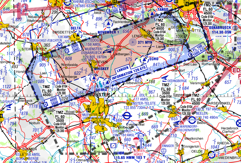
IFR arrivals and departures require increased attention in the vicinity of aerodromes, which is why so-called Radio Mandatory Zones (RMZ) have been introduced at aerodromes with IFR traffic. These are airspace class G and therefore uncontrolled.
The AIP for Germany states that aircraft intending to fly into an RMZ must make an introductory call on the published frequency to declare their intentions. In the example, the published frequency of ‘Schwäbisch Hall Information’ should be used and the following content transmitted:
- Identification of the called station
- Call sign and aircraft type
- Location, level and intentions
| Durchflug RMZ / Transition through RMZ | ||
| Station | ||
| Pilot | Schwäbisch Hall Information, DELFE | Schwäbisch Hall Information, DELFE |
| ATC | DELFE, Schwäbisch Hall Information | DELFE, Schwäbisch Hall Information |
| Pilot | DELFE, C172, 5 NM nördlich Braunsbach, 2000 Fuß, werde in die RMZ einfliegen und entlang des Kocher Richtung Süden verlassen | DELFE, C172, 5 NM north of Braunsbach, 2000 feet, will cross RMZ southbound via the River Kocher |
| ATC | DELFE, verstanden, QNH 1008, Verkehr, C152 im kurzen Endanflug Piste 28 | DELFE, roger, QNH 1008, traffic, C152 on short final runway 28 |
| Pilot | DELFE, QNH 1008, Verkehr in Sicht, bleibe frei | DELFE, QNH 1008, traffic in sight, will stay clear |
| Pilot | DELFE über Rosengarten, 2000 Fuß, hat die RMZ verlassen | DELFE over Rosengarten, 2000 feet, left the RMZ |
| ATC | DELFE, verstanden, tschüss | DELFE, roger, bye |
During the flight through the RMZ, the pilot must continually monitor the frequency. Initiatial calls by pilots are made in the same way as traffic pattern messages and do not need to be acknowledged or confirmed by AFIS. Pilots intending to land or take off at the aerodrome will generally continue to use the shorter introductory call to establish communication.
If the corresponding AFIS position is not occupied on Vatsim, the blind messages must be made on Unicom 122.800.
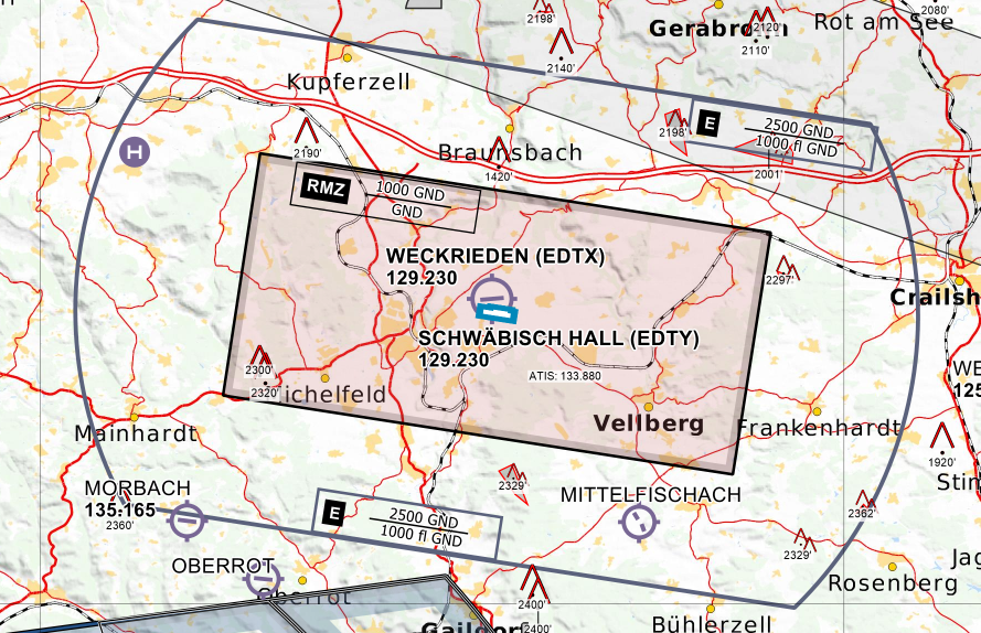 RMZ Schwäbisch Hall EDTY - © openflightmaps.org
Altimetry
Flight Level, Altitude, Height, Elevation, Level - All the Same? Not at All...
Terminology
Let's clear up any confusion you might have regarding these terms. We'll go through the terms related to altitude measurement / altimetry step by step:
- Level
Definition according to ICAO:A generic term relating to the vertical position of an aircraft in flight and meaning variously, height, altitude or flight level.
The term "Level" is thus an umbrella term for Height, Altitude, and Flight Level. If I want to ask a pilot how high he is, I would use the term "Level" ("Report Level"), as I, as a controller, cannot know whether the pilot is currently seeing an Altitude, Height, or a Flight Level in his cockpit. - Flight Level always refer to the height of the standard 1013 hPa pressure surface. Where this level is located depends on the prevailing weather conditions. If a high-pressure system is present, this level is higher, and vice versa. So, if an aircraft is flying at Flight Level 100 over the ocean, the height above the ground depends on the ground-level air pressure. On a day with standard conditions (1013.25 hPa at MSL - International Standard Atmosphere), the aircraft would actually be 10,000 feet above the sea. If ground pressure is higher, the aircraft at FL100 will be higher than 10,000 feet above the ground, and in a low-pressure system, it will be lower than 10,000 feet above the ground.
- When referring to Altitudes, we are talking about an altimeter reading with the reported QNH in the subscale setting. The QNH is determined by the current air pressure measured at the airport and is announced in the METAR. Setting the QNH on the altimeter should indicate the airfield elevation on the ground, so the altitude above MSL is displayed for the current conditions at the airfield.
- A Height corresponds to the level above ground. The necessary subscale setting QFE corresponds to the air pressure at the airport and can also be determined similarly to the QNH by adjusting the setting until the altimeter reads 0 feet.
- Elevation describes the altitude above sea level of a stationary object, such as an airport, obstacle, etc. The relationship is Elevation + Height = Altitude.
When Does the Controller Use Which Term?
Important for the application of Air Traffic Control Service are primarily Altitude and Flight Level, as these are the two level terms used in aviation to establish vertical separation. But when do we use Flight Level, and when Altitudes?
In Germany, the so-called Transition Altitude (TA) - the altitude at which an aircraft in a climb switches its altimeter from QNH to standard pressure - is always at 5000 feet. Consequently, below the Transition Altitude, Altitudes (with QNH reference) are used, and above it, Flight Levels (FL).
Additionally, there is the Transition Level (TL). This is the lowest usable flight level above the Transition Altitude. In practice, this means that during descent, you fly using Flight Levels with the standard pressure reference until the Transition Level, and below that, with Altitudes.
The Transition Level is chosen based on air pressure so that there is always at least 1000 feet between the Transition Level (TL) and the Transition Altitude (TA). The TL is usually at FL60 or FL70. However, in cases of extreme air pressure, it can also be at FL50 or FL80. The following table shows the respective Transition Levels based on air pressure:
| QNH ab | QNH bis | Transition Level |
| 943 | 977 | FL 80 |
| 978 | 1013 | FL 70 |
| 1014 | 1050 | FL 60 |
| 1051 | FL 50 |
Vertical separation for approach controllers
As mentioned earlier, a Transition Level does not necessarily correspond to the true altitude of an aircraft. Instead, the actual altitude depends on the current air pressure. If the air pressure is higher than 1013.25 hPa, an aircraft at FL60 is actually higher than 6000 feet. If the pressure is lower than 1013.25 hPa, an aircraft at FL60 is actually lower than 6000 feet. The following image illustrates this:
 Photo: Kreuzschnabel/Wikimedia Commons, License: artlibre
For separation, this means:
-
If two aircraft are both flying at Flight Levels, they are vertically separated regardless of air pressure if they have a 10-flight-level (1000-foot) gap, e.g., FL60 and FL70; FL70 and FL80, etc., as every aircraft is using the standard pressure setting, so the difference from the actual height is the same for each aircraft.
-
However, if one aircraft is flying at an Altitude and another at a Flight Level, they may not be separated depending on the air pressure:
- Example 1: 5000 feet and FL60 are not separated at a pressure of 1013 hPa or less, as the aircraft at FL60 is actually flying lower than 6000 feet, e.g., 5800 feet → no 1000-feet separation.
- Example 2: 5000 feet and FL60 are separated at a pressure of 1014 hPa or more, as the aircraft at FL60 is actually flying higher than 6000 feet, e.g., 6200 feet → more than 1000-feet separation.
Therefore, aircraft in descent should only be allowed to fly at Flight Levels until the Transition Level, and ideally cleared only to 5000 feet on Altitudes, to ensure separation is always maintained.
If an aircraft is cleared, for example, to 6000 feet, another aircraft at FL70 is only vertically separated if the pressure is ≥ 1014 hPa; otherwise, there is no vertical separation.
For further reading: Altimeter Pressure Settings.
Flight plan
A flight plan specifies how a flight is planned to be conducted. Along with the callsign and aircraft type, it also includes the planned route, altitude, and speed. This ensures that both the pilot and the controller are on the same page with the flight's planning.
Flights under Instrument Flight Rules (IFR) are always required to file a flight plan, whereas flights under Visual Flight Rules (VFR) have the option to do so.
On VATSIM, it is important to note that once a flight plan has been edited by a controller, the pilot can no longer modify it themselves!
Flight plan format
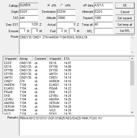
The format of flight plans is identical worldwide and prescribed by ICAO. It’s possible that a flight plan may not appear in the classic input fields but instead in the following format. This format includes all the key information that air traffic control needs to know from the pilot:
(FPL-DLH5YK-IS -A320/M-SDE3FGHIRWY/LB1 -EDDF1220 -N0444F230 CINDY3S CINDY Z74 HAREM T104 ROKIL ROKIL1B -EDDM0105 EDDS -PBN/A1B1C1D1O1S1 DOF/210625 REG/DAIZD RMK/TCAS)
However, since this format can be somewhat unclear and prone to errors during manual entry, VATSIM provides both controllers and pilots with various input forms for the flight plan (see below)
Flight strip
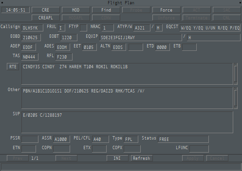
Controllers on Euroscope see the most important information from the flight plan on the flight strip. This can be displayed by pressing the F6 key.

Euroscope flight strip for a flight from Frankfurt to Munich.
Flight plan fields for controllers
In most cases, the standard Euroscope flight plan window is used to process flight plans. With the TopSky plugin, there is also a separate flight plan window for controllers. The content is mostly the same but displayed differently. The following lists mainly refer to the Euroscope flight plan window. It's important to note that these differ from the official ICAO flight plan form!
|
|
|
| Euroscope flight plan |
Topsky flight plan |
| Euroscope | Topsky | Meaning |
| Callsign | Callsign | Callsign |
| IFR/VFR | FRUL | Flight rules |
| AP data | ATYP | Aircraft type / equipment |
| Origin | ADEP | Departure airport |
| Destination | ADES | Destination airport |
| Alternate | ALTN | Alternate airport |
| TAS | TAS | True Air Speed (TAS) |
| Altitude | RFL | Cruising altitude |
| Squawk | ASSR | Transponder code |
| Dep EST | EOBT | Estimated Off-Block Time (EOBT) |
| Actual | -- | Actual time |
| Temp alt | PEL / CFL | Temporary altitude |
| Enroute | EET | Estimated flight time |
| Fuel | -- | Amount of fuel on board |
| RFL | -- | Requested flight level |
| Route | RTE | Planned route |
| Remarks | Other | Remarks |
Flight rule change
In addition to major airports and airfields with an RMZ (Radio Mandatory Zone), there are many smaller airfields that do not have published IFR procedures. At these airfields, operations must always be conducted under Visual Flight Rules (VFR) for takeoff or landing. If the flight is to be conducted under Instrument Flight Rules (IFR) (e.g., due to weather conditions), the flight plan must either begin or end in the air. In Germany, the Y and Z flight plans indicate a change in flight rules during the flight.
Apart from the absence of IFR procedures, worsening weather can also cause a situation where VFR is no longer permitted in the airspace where the aircraft is located, forcing the pilot to switch to IFR.
In a Y flight plan, the pilot starts the flight IFR and later switches to VFR.
In a Z flight plan, the pilot starts VFR and later switches to IFR.
Yankee Flight Plan (IFR-Cancellation)
In a Y flight plan, the switch from IFR to VFR occurs, meaning that the departure is conducted under IFR and the approach under VFR. This is necessary, for example, when the destination airport does not have published IFR procedures (e.g., Egelsbach EDFE).
The pilot requests cancellation of IFR from the controller at or before the last waypoint. At this point, the pilot must be in Visual Meteorological Conditions (VMC), otherwise, the switch is not (yet) possible. The controller does not need to ensure that the pilot is in VMC. When the pilot announces the intention to end the IFR part with the phrase "CANCELLING MY IFR FLIGHT," it implies that they are in VMC.
If the pilot is switching in Class C or D airspace, they must be informed how to exit this airspace or whether the further flight will be conducted under VFR. This instruction is given along with the IFR cancellation.
The switch from IFR to VFR may only take place above the Minimum Vectoring Altitude (MVA) or on published IFR procedures (SID, STAR, approach procedures, airways) above the respective minimum altitude.
In the flight plan, the route is specified as in the following example from Stuttgart (EDDS) to Egelsbach (EDFE). The blue section represents the IFR part, and the green section represents the VFR part of the flight, with the switch occurring at the SPESA waypoint.
ETASA T163 SPESA VFR DCT
The pilot receives a standard IFR clearance in Stuttgart, except that it only extends to the last waypoint before the planned change in flight rules, in this case, SPESA. SPESA is therefore the Clearance Limit. As the pilot approaches this clearance limit, the controller should issue a lateral clearance to SPESA (heading, STAR, holding), so both parties know what the pilot will do upon reaching the clearance limit, assuming they haven’t yet canceled the IFR flight.
The controller should not prompt the pilot to end the IFR flight; the initiative must come from the pilot.
The general procedure is as follows:
- The pilot explicitly announces the change in flight rules with the phrase: "CANCELLING MY IFR FLIGHT."
- The controller reports the exact time the flight rule change took place. If necessary, the pilot must be given instructions on how to exit controlled airspace.
- When possible, the pilot is instructed to set the transponder to VFR and is approved to leave the frequency.
Cancellation in der the traffic ciruit (Tower)
Here too, the pilot must be in VMC at the time of the flight rule change and must report this. Furthermore, the aircraft must be on a published procedure and at its minimum altitude (usually the ILS approach).
The general procedure is:
- The pilot announces the flight rule change with the phrase: "CANCELLING MY IFR FLIGHT."
- The controller reports the exact time or the altitude at which the IFR flight rules are terminated and the current position. They also inform the pilot of what to do next (e.g., "after Touch-and-Go, join traffic pattern RWY 23L") and instruct the pilot to set the transponder to VFR.
Phraseology examples
Example of IFR Clearance for the Y Flight Plan:
| Station | Phraseology |
| Pilot | Stuttgart Delivery, DESAG at GAT, Info B, request startup and IFR-clearance. |
| ATC | DESAG, Stuttgart Delivery, startup approved, cleared to SPESA, *via* ETASA2H departure, flight planned route, climb to *altitude* 5000ft, Squawk 2215. |
| Pilot | Startup approved, cleared to SPESA, ETASA2H departure, flight planned route, climbing to *altitude* 5000ft, Squawk 2215, DESAG. |
Example of IFR Cancellation - Airspace E:
| Station | Phraseology |
| Pilot | DESAG cancelling my IFR flight. |
| ATC | DESAG, IFR cancelled at 1520z, Squawk VFR, approved to leave frequency |
| Pilot | IFR cancelled, Squawk VFR, approved to leave frequency |
Example of IFR Cancellation - Airspace C or D:
| Station | Phraseology |
| Pilot | DESAG cancelling my IFR flight. |
| ATC | DESAG, leave airspace C/D (to below) on present heading, IFR cancelled at 1520z. |
| Pilot | Leaving airspace C/D (to below) on present heading, IFR cancelled, DESAG |
| Anmerkung: Der Pilot befindet sich nun außerhalb C/D. |
|
| ATC | DESAG, you are leaving airspace C, Squawk VFR, approved to leave frequency |
| Pilot | Squawk VFR, approved to leave frequency, DESAG, bye. |
Example of IFR Cancellation - Tower Control Zone:
| Station | Phraseology |
| Pilot | Düsseldorf Tower, DESAG on ILS approach RWY 23L, cancelling my IFR flight and continue VFR for Traffic pattern. |
| ATC | DESAG, IFR cancelled at time 0910 zulu, position 5nm final RWY 23L, squawk VFR. After Touch-and-Go join traffic circuit RWY 23L. Wind 20004kt, RWY 23L cleared for Touch-and-Go. |
| Pilot | IFR cancelled at time 0910 zulu, squawk VFR, after Touch-and-Go joining traffic circuit RWY 23L. RWY 23L cleared for Touch-and-Go, DESAG |
Zulu Flight Plan (IFR Pickup)
In a Z flight plan, the flight rule change occurs from VFR to IFR. The IFR clearance is received from the radar controller during the flight, which is why it is also known as an IFR Pickup. The flight plan specifies where the IFR portion should begin. In addition to the waypoint, the speed-level group must also be specified (see example).
The squawk code must be given to the pilot before the enroute clearance since the aircraft must be identified before being cleared. This includes the Clearance Limit (in the example, the destination airport), the route the aircraft will take to its first waypoint or the planned route (usually direct), and an initial altitude clearance, along with the information on when the IFR portion begins (the pilot must be above the MVA). If the pilot is already above the MVA, the IFR portion can begin immediately (IFR starts now).
Depending on traffic and airspace structure, the IFR pickup may occur later or at a different location than planned.
Here’s an example flight from Egelsbach back to Stuttgart. The IFR portion is set to begin at RID, with a true airspeed (TAS) of 180 KT at a cruising altitude of FL130.
DCT CHA DCT RID/N0180F130 IFR Y163 NEKLO Y171 INKAM N850 KRH T128 BADSO
The pilot departs Egelsbach and flies VFR over the CHA VOR to the RID VOR. Here, he wishes to switch flight rules.
Procedure
At the time of the flight rule change (not the clearance), the pilot must be above the Minimum Vectoring Altitude (MVA) or on a published procedure at its minimum altitude. If not, the pilot must be informed that the IFR clearance will only become effective after passing the MVA or reaching the published procedure. For the pickup, the pilot will be given a squawk code shortly before their desired point in the air, which allows them to be identified and receive IFR clearance.
The general procedure is as follows:
- The pilot requests an IFR pickup.
- The controller assigns a squawk code and identifies the aircraft.
- The controller gives the pilot full IFR clearance to the destination, including route guidance (cleared level). There must also be instructions on how to proceed from the current position to the first waypoint of the IFR route and when exactly the IFR portion of the flight begins (e.g., "right now," "when passing 5000 feet," or "IFR starts after RID").
- The pilot must read back the clearance.
Similar to the exit procedure in a Y flight plan, the pilot must also be cleared to enter Class C or D airspace and be given any relevant instructions if the IFR portion starts within that airspace.
Phraseology
| Station | Phraseology |
| Pilot | Langen Radar, good day, DEKSA. |
| ATC | DEKSA, Langen Radar, good day. |
| Pilot | DEKSA, Cessna 172, departed Egelsbach, 10 miles north-east of RID VOR, 1200ft, request IFR clearance to EDDS. |
| ATC | DSA, Squawk 2140, QNH 1013. |
| Pilot | Squawk 2140, QNH 1013, DSA. |
| ATC | DEKSA, identified, cleared to Stuttgart via RID VOR (this means: Direct RID), flight planned route, climb to *altitude* 5000ft, IFR starts after passing 3500ft. |
| Pilot | Cleared to Stuttgart via RID VOR, flight planned route, climbing to *altitude* 5000ft, IFR starts after passing 3500ft, DSA. |
| ATC | DSA, readback correct. |