# Altimetry
Flight Level, Altitude, Height, Elevation, Level - All the Same? Not at All...
#### Terminology
Let's clear up any confusion you might have regarding these terms. We'll go through the terms related to **altitude measurement / altimetry** step by step:
- **Level**
Definition according to ICAO: > *A generic term relating to the vertical position of an aircraft in flight and meaning variously, height, altitude or flight level.*
The term "Level" is thus an umbrella term for **Height**, **Altitude**, and **Flight Level**. If I want to ask a pilot how high he is, I would use the term "Level" ("Report Level"), as I, as a controller, cannot know whether the pilot is currently seeing an **Altitude**, **Height**, or a **Flight Level** in his cockpit.
- **Flight Level** always refer to the height of the standard 1013 hPa pressure surface. Where this level is located depends on the prevailing weather conditions. If a high-pressure system is present, this level is higher, and vice versa. So, if an aircraft is flying at Flight Level 100 over the ocean, the height above the ground depends on the ground-level air pressure. On a day with standard conditions (1013.25 hPa at MSL - International Standard Atmosphere), the aircraft would actually be 10,000 feet above the sea. If ground pressure is higher, the aircraft at FL100 will be higher than 10,000 feet above the ground, and in a low-pressure system, it will be lower than 10,000 feet above the ground.
- When referring to **Altitudes**, we are talking about an altimeter reading with the reported **QNH** in the subscale setting. The QNH is determined by the current air pressure measured at the airport and is announced in the METAR. Setting the QNH on the altimeter should indicate the airfield elevation on the ground, so the altitude above MSL is displayed for the current conditions at the airfield.
- A **Height** corresponds to the level above ground. The necessary subscale setting **QFE** corresponds to the air pressure at the airport and can also be determined similarly to the QNH by adjusting the setting until the altimeter reads 0 feet.
- ***Elevation*** describes the altitude above sea level of a stationary object, such as an airport, obstacle, etc. The relationship is **Elevation + Height = Altitude**.
#### When Does the Controller Use Which Term?
Important for the application of Air Traffic Control Service are primarily **Altitude** and **Flight Level**, as these are the two level terms used in aviation to establish vertical separation. But when do we use **Flight Level**, and when **Altitudes**?
In Germany, the so-called **Transition Altitude (TA)** - the altitude at which an aircraft in a climb switches its altimeter from QNH to standard pressure - is always at 5000 feet. Consequently, below the Transition Altitude, **Altitudes** (with QNH reference) are used, and above it, **Flight Levels (FL)**.
Additionally, there is the **Transition Level (TL)**. This is the lowest usable flight level above the Transition Altitude. In practice, this means that during descent, you fly using Flight Levels with the standard pressure reference until the Transition Level, and below that, with Altitudes.
The **Transition Level** is chosen based on air pressure so that there is always at least 1000 feet between the Transition Level (TL) and the Transition Altitude (TA). The TL is usually at FL60 or FL70. However, in cases of extreme air pressure, it can also be at FL50 or FL80. The following table shows the respective Transition Levels based on air pressure:
| **QNH ab** | **QNH bis** | **Transition Level** |
| 943 | 977 | FL 80 |
| 978 | 1013 | FL 70 |
| 1014 | 1050 | FL 60 |
| 1051 |
| FL 50 |
If you've understood the difference between **Altitude** and **Flight Level** and that, for example, at a QNH of 1051, 5000 feet and FL50 are not the same height but are actually 1000 feet apart, then you're becoming an altimetry expert. However, this topic is anything but trivial.
#### Vertical separation for approach controllers
As mentioned earlier, a **Transition Level** does not necessarily correspond to the true altitude of an aircraft. Instead, the actual altitude depends on the current air pressure. If the air pressure is higher than 1013.25 hPa, an aircraft at FL60 is actually higher than 6000 feet. If the pressure is lower than 1013.25 hPa, an aircraft at FL60 is actually lower than 6000 feet. The following image illustrates this:
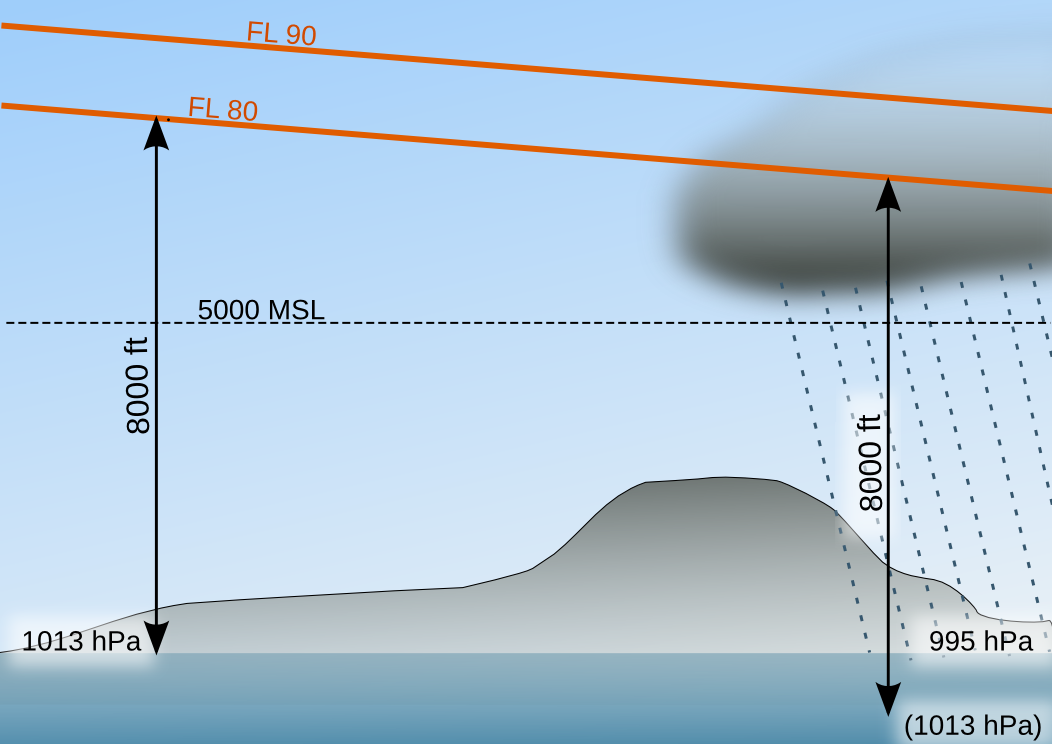Photo: Kreuzschnabel/Wikimedia Commons, License: [artlibre](http://artlibre.org/licence/lal/de)
**For separation, this means:**
- If two aircraft are both flying at **Flight Levels**, they are vertically separated regardless of air pressure if they have a 10-flight-level (1000-foot) gap, e.g., FL60 and FL70; FL70 and FL80, etc., as every aircraft is using the standard pressure setting, so the difference from the actual height is the same for each aircraft.
- However, if one aircraft is flying at an **Altitude** and another at a **Flight Level**, they may not be separated depending on the air pressure:
- Example 1: 5000 feet and FL60 are not separated at a pressure of 1013 hPa or less, as the aircraft at FL60 is actually flying lower than 6000 feet, e.g., 5800 feet → no 1000-feet separation.
- Example 2: 5000 feet and FL60 are separated at a pressure of 1014 hPa or more, as the aircraft at FL60 is actually flying higher than 6000 feet, e.g., 6200 feet → more than 1000-feet separation.
Therefore, aircraft in descent should only be allowed to fly at Flight Levels until the Transition Level, and ideally cleared only to 5000 feet on Altitudes, to ensure separation is always maintained.
If an aircraft is cleared, for example, to 6000 feet, another aircraft at FL70 is only vertically separated if the pressure is ≥ 1014 hPa; otherwise, there is no vertical separation.
For further reading: [Altimeter Pressure Settings](https://skybrary.aero/articles/altimeter-pressure-settings).