We ask all pilots to also read the [General section](https://knowledgebase.vatsim-germany.org/books/airports-langen-fir-edgg/page/general-Wgj "EDLN Pilotbriefing General") with **information relevant to all pilots**.
Mönchengladbach’s airspace and general traffic levels make the airport **very friendly to VFR traffic** in the real world. As this is similar on VATSIM, controllers will usually be able to accommodate VFR requests. However, pilots should keep the **airport's location within the Köln/Düsseldorf TMA, Germany's most complex airspace**, as well as its **direct border to the [Düsseldorf](https://knowledgebase.vatsim-germany.org/books/airports-langen-fir-edgg/chapter/eddl-dusseldorf "Pilotbriefing EDDL") CTR** in mind. ### Airspace Structure ##### CTR The Mönchengladbach CTR has a **top altitude of 2000 ft MSL, about 1800 ft AGL**. Please pay close attention to setting the correct QNH and your altitude to avoid inadvertently entering **airspace C above**. The following mandatory reporting points exist around the airport:| **Reporting point** | **Use** | **Location** |
| **G** | **Entry/Exit** from/to the S | industrial district Giesenkirchen-Nord |
| **K1** | **Entry/Exit** from/to the N *on K route* | quarry lake Kempen |
| **K2** | **Entry/Exit** from/to the N *on K route* | roundabout NW of St. Tönis |
| **M** | **Entry/Exit** from/to the NE | DHL distribution center Krefeld |
| **R** | **Entry** from the SW | highway A61 exit Wickrath |
| **W** | **Entry/Exit** from/to the W | highway intersection A52/A61 |
Keep in mind that ATC might instruct you to use a different reporting point than the one you requested, if necessary.
### Departure & Arrival The **maximum altitude** for all departures and arrivals is 2000 ft AMSL. ### Traffic circuit Mönchengladbach has a **recommended (albeit not mandatory) traffic circuit in the North and in the South**. Pilots should follow these circuits whenever no contrary instruction has been given by ATC. More information can be found on the [airport's website](https://www.mgl.de/aviation/#piloten "Pilot Information on EDLN Airport Website (German only)"). The Northern circuit is at an altitude of **1200ft AMSL**, the Southern circuit is at an altitude of **1100ft AMSL**. 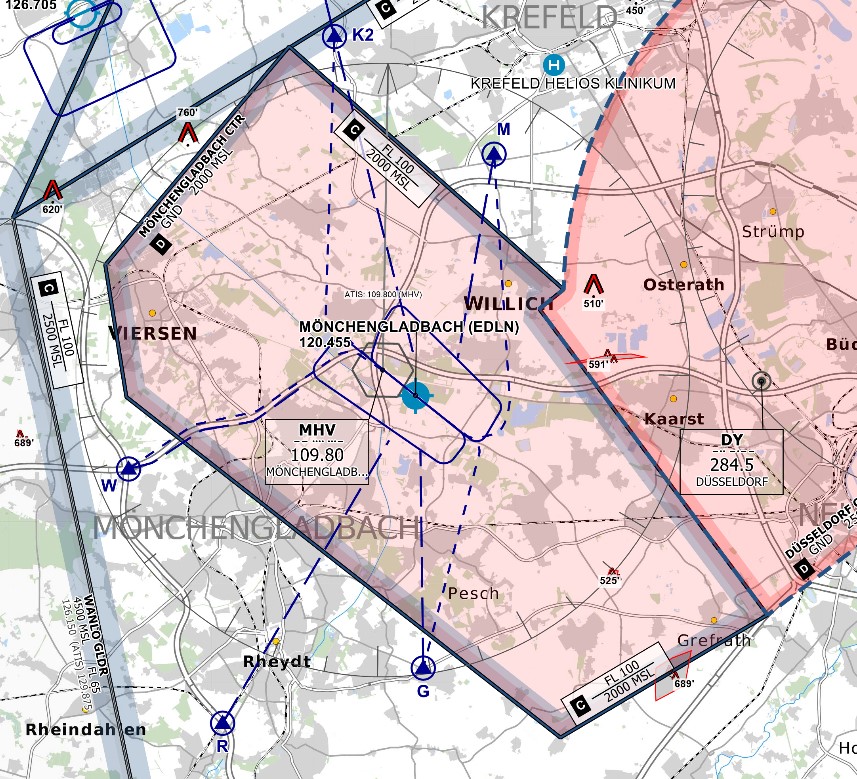 *© [openflightmaps.org](https://www.openflightmaps.org/)*