Military Procedures
- Introduction
- Military Tower
- Military Radar
- TRAMON
- Military Enroute
- Formation Flights
- Air to Air Refuelling (AAR)
- Restricted Areas
- Scramble
- Fighter Control
Introduction
This guide is meant for ATC and tries to give an overview over the most common topics in regard to military operations on Vatsim. Be advised that some of these topics may only be performed by pilots who are part of a Vatsim Special Operations (VSO) Organisations such as vNATO or vUSAF. For reference see the the Virtual Airlines Partner Policy. To the author of this guide it seems as if Air to Air Refueling and Scramble for the purpose to intercept another aircraft may not be performed by pilots who are not part of a VSO Organisation. All other procedures mentioned in this article can in theory be performed by any pilot on the network, however, it is advised to first check with ATC before attempting any of the more special operations.
Lastly, I - the author of this article - want to make clear that the available information for this topic is limited. Most of the explanations and examples in this guide are based on trustworthy but incomplete information. Thus, the trustworthy bits of information are combined with good guesses to try to make sense of it and to try to paint a complete picture. I hope that in the future, the military knowledge of this guide can be the basis for further corrections and expansion of knowledge.
Military Tower
In general, Military Airfields work a little different to the airports that you might be familiar with. They have a control tower and a radar station that you might call approach. However, the radar airspace is not nearly as high as the approach airspace you are familiar with. But first we will look at the Tower position.
Reference Documentation
Charts and Maps for German Military airfield and Airspace can be found on the Mil AIP (www.milais.org).
Weather Information
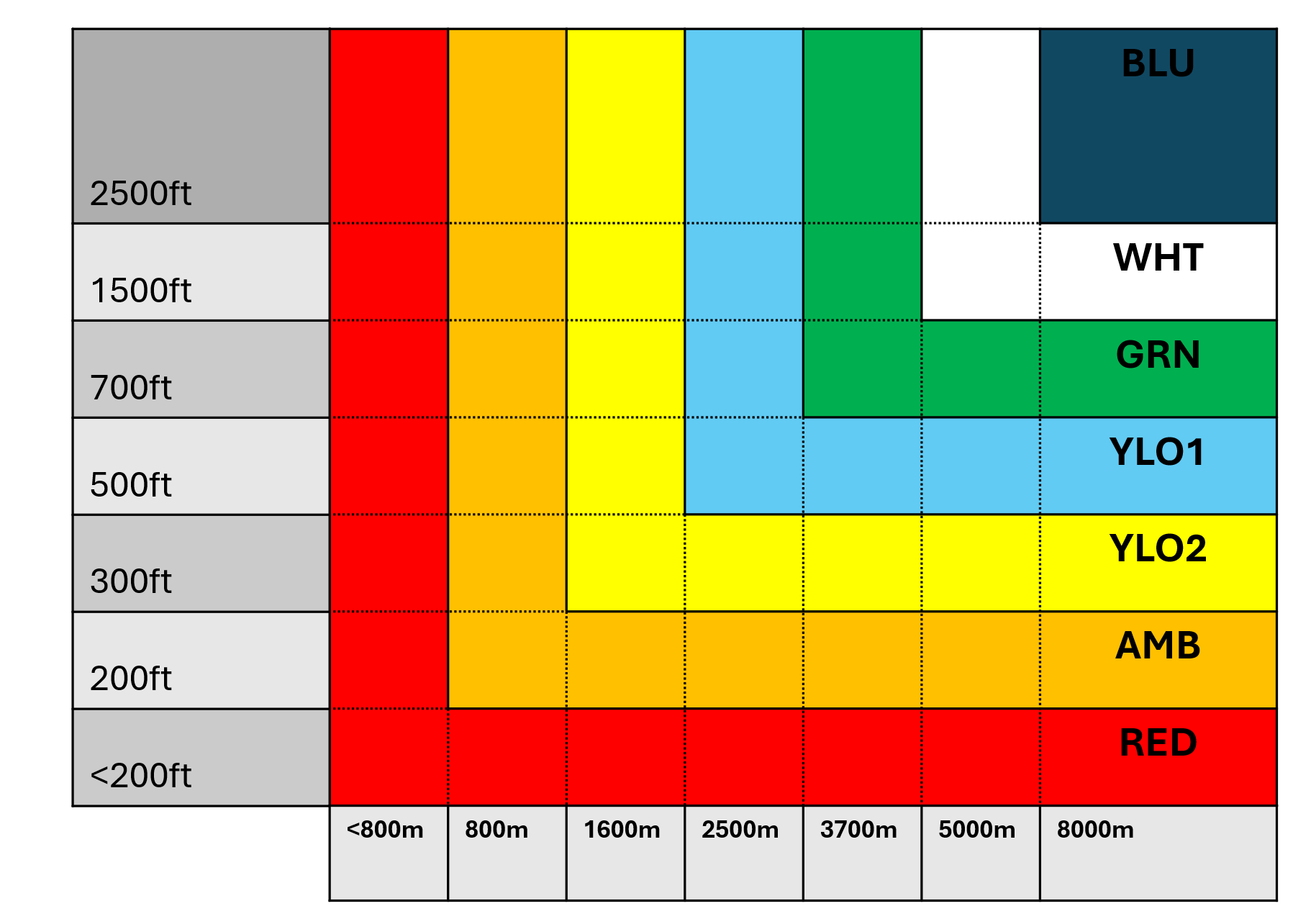
Airfield color states
As opposed to normal TWRs, military TWRs do not offer an ATIS. Instead, the weather information is given as a color code. Additionally, the QNH and the active runway have to be communicated to the pilot. The color codes and the respective weather are listed below. In case the visibility and cloud ceiling color do not match, the color corresponding to the worst weather of the two is published.
- Blu+: cloud ceiling (more than half of the sky is covered) below 20000ft. (not BKN or OVC below 20000ft)
- Blu: visibility 8000m, cloud ceiling at least 2500ft
- WHT: visibility 5000m, cloud ceiling at least 1500ft
- GRN: visibility 3700m, cloud ceiling at least 700ft
- YLO1: visibility 1600m, cloud ceiling at least 500ft
- YLO2: visibility 1600m, cloud ceiling at least 1600ft
- AMB: visibility 800m, cloud ceiling at least 800ft
- Red: visibility less than 800m, cloud ceiling less than 200ft or VV//
- Black: Runway closed for other reason than weather
White is still considered sufficient for VMC operations while Green requires IFR procedures.
Formation Flights
Formation flights shall be controlled/cleared as a single aircraft unless the formation leader requests otherwise.
Radio communication flow is strictly between the formation leader and the controller.
The controller should expect a radio roll call from all wingmen before being contacted by the leader. (i.e: NATO11 check... 12... 13... 14. Laage Tower NATO11)
Should a call be addressed to a specific wingman, the controller must use the aircraft callsign including the sequence number. (i.e: NATO13 Laage Tower squawk stand-by)
The responsibility for landing interval between elements of a formation flight rests with the pilots in the formation.
Pilots may transmit codewords when airborne to confirm the visual and radar contact within the formation. These codewords are:
- SHINING Wingman claims a radar lock on the leader
- BUDDY SPIKE (SPOT) Leader confirm the radar lock (via ECM)
- TIED ON Remaining locked on the leader
- IN VISUAL TRAIL Keeping visual
- HOLDING HANDS Aircraft are joined up.
TAXI
Taxi clearance
Taxi clearance shall be obtained prior to taxiing. Formation leaders may obtain taxi clearance for their entire flight. A clearance to taxi to the runway authorizes the aircraft to cross all taxiways that the taxi route intersects except the assigned takeoff
runway. Pilots shall read back all hold/hold short instructions received during taxi.
Furthermore, military airfields rarely have multiple taxiways and if they do, they have standardized taxi routes. Therefore, you do not need to name taxiways when giving the taxi clearance. You also have to ask the DFS radar station for a departure release before issuing a takeoff clearance due to the low radar airspace.
Overtaking
No taxiing aircraft shall overtake or pass another aircraft except with tower approval.
Taxi speed
All aircraft shall be taxied at a safe rate of speed and under positive control of the pilot at all times.
Last chance area
Military airfield operating jet aircraft are equipped with Last chance areas next to the runway. These areas can be used by pilots to perform the Last Chance Check on the aircraft before departure or, if they are equipped with weapons, to pull the safety pins of the weapons. Tower doesn't need to instruct the pilot to taxi to this area, if a pilot requires to stop there, he will do this on his own.
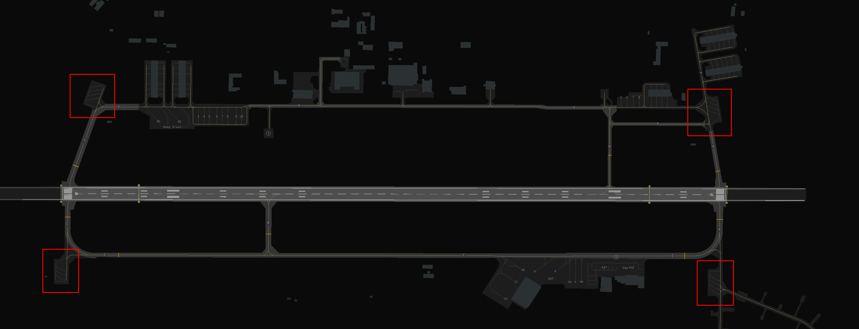
Last chance area at Laage (ETNL)
Alert Scramble (QRA)
Quick Reaction Alert (QRA) is a state of readiness and responsiveness maintained by air forces and other military bodies worldwide. Its purpose is to deter, detect, and counter threats promptly.
When the order to take-off (scramble) is triggered, the alert aircraft (single or in pair) have a minimum delay to take-off. Therefore, they shall be prioritized over all other traffic.
TAKE-OFF
ATC Clearance
Aircraft departing on IFR flight plans must be provided with their ATC clearance on Tower control. Departing pilots shall read back clearances differing from the filed flight plan. Standard procedure is to give the aircraft an taxi instruction before the IFR clearance.
Just like a DFS Tower, the military Tower is in control of a CTR and all ground movements. However, it cannot issue IFR clearances. Instead IFR clearances are requested at the responsible DFS station via telephone. First, the DFS station transmits the clearance to the military Tower that confirms it with his initials (No readback for the DFS Station required). Then the military Tower transmits the clearance to the pilot, who reads it back to the Tower. In real life the military Tower first calls the military Radar who then calls the DFS station, but I think we can skip this step ;)
IFR clearances are similar to those you are used to. They simply contain the point that the aircraft is cleared to, "first fix" (A fix somewhere on the flight plan), the SID/OID, a squawk and instructions whom to contact when airborne. They may contain a flight level but that is often left blank for convenience. Military Aircraft usually aren't instructed to follow a SID but an OID (operational instrument departure) which is similar to a SID. They are usually named with the last two letters of the ICAO code of the airport and a number (e.g. NL19, pronounced November-Lima-one-niner). You can find these on Navigraph and in the AIP. However, if the SIDs have names or if the aircraft is flying according to a civil aviation flight plan (fixes and airways) then you should assign a SID if available (like ETOU or ETNL).
Takeoff Clearance
Another specialty of Military TWRs is that the wind is given during line up and take off. This is because especially formation flights have a lower crosswind limits for formation takeoffs and the pilots need to know before line up if they can depart as a formation or if they need to depart individually.
Frequency Changes
Military aircraft may receive an radio handoff to the next radar station with the takeoff clearance.
Departures and Arrivals
- IFR Aircraft departing IFR will be transferred to Approach controller as soon as possible or allready on the runway.
- VFR Aircraft departing VFR will proceed through the published trajectories to the CTR exit point or leave the CTR to the top.
Most Military airports have special VFR Arrival and departure routes published in the VFR Charts. These VFR Jet arrivals and VFR Jet departures are used for military Jets. The Jet arrival normally consists of one mandatory reporting point outside the CTR and its respected Initial point in front of the runway.
e.g. Jets will enter Laage CTR via an Entry at 1700 ft and up to 300 kt.
It’s important to remember that Jets on the VFR Jet arrival will normally overfly the airport to make an Overhead Approach Maneuver and then join the final as published in the chart!
Visual Jet Arrival and Departure routes in Laage (ETNL)
Circuit and Landing
Aircraft engaged in the airfield circuit must be in radio communication with the ATC Tower controller.
Before landing, when turning on base or when on final, a pilot must declare his landing gear is down and locked by the expression:
“GEAR DOWN AND LOCKED”.
When a Pilot forgets to declare the expression mentioned above, the ATC must request confirmation by using the expression: “Confirm gear down and locked?” or “Check gear down and locked”
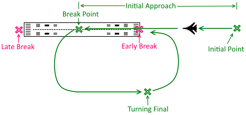
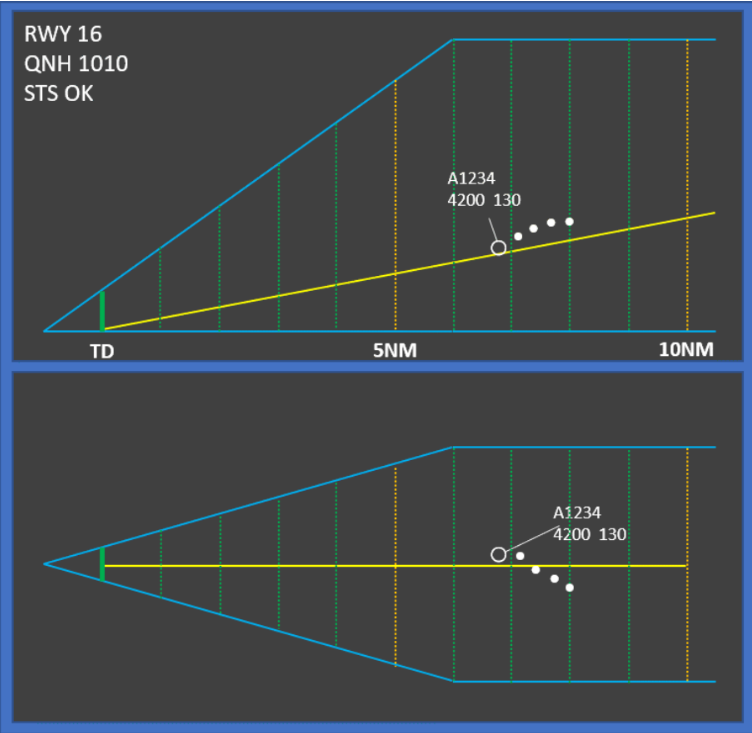
Overhead Approach Maneuver (Break arrival)
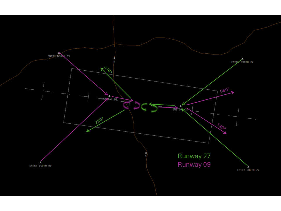
The Overhead Approach Maneuver is a visual procedure that is used at military airports for the use of military jets flying VFR. These jets usually carry a lot more kinetic energy than civil aircraft do and need to dissipate that energy before landing. For this purpose the procedure is published on military airports. This is equivalent to a carrier approach. You can find the charts in the German Military AIP designated as VAD. Some examples for airports with this procedure are ETHC, ETNG, ETSB, ETSH, ETNL, ETNT but there are more. In these charts you will always find an Entry Point and a predetermined route that leads to the "Initial". The "Initial" is a point about 2 NM from the runway.
 Overhead Approach Maneuver
The procedure after the Initial is depicted on the right. The Military jet will approach with 300 kts indicated airspeed and descend to the published altitude of the procedure. Usually, the published altitude is about 1000ft-2000ft higher than the airport elevation. The aircraft will then overfly the runway until reaching the break point. The standard break point is in the middle of the runway upon which the aircraft will enter a 3G turn to either side and decelerate in that turn. It is possible to fly this procedure faster but then the pilots needs to pull harder and thus increase the centrifugal force in the turn. In simple words: The harder the pilot pulls the better the deceleration.
The jet will then continue in the traffic circuit while still decelerating. On downwind the pilot also puts down flaps and gear. The pilot should reach the approach speed before initiating the final turn. After about half of the final turn the jet will start descending towards the runway on which it will land. As you can see in the picture, the break can be flown early and late which gives ATC the opportunity to sequence aircraft in case ATC deems it necessary, however, because this is a visual maneuver, the sequencing should be done with traffic information and numbering.
In general, it is very easy to dissipate energy in this maneuver which is why it is preferable for military jets. Furthermore, this procedure minimizes the time that aircraft spend low and slow, thus, minimizing the time that these jets are most vulnerable.
Important points:
- Initial is a mandatory reporting point
- On downwind the pilot can be asked whether he intends to do a touch and go, low approach or full stop landing.
- This procedure is an easy way to dissolve a formation for individual landings if requested by the pilot. The formation will continue to the break point like with the normal procedure. At the break point the first aircraft will enter the break turn. After a few seconds the second aircraft will enter the break turn and this will continue until the last aircraft enters the break turn and the formation proceeds to land individually.
- As always with military jets: On Crosswind or final the pilot has to be reminded to check the landing gear "Check gear down" unless he has reported gear down before that point.
- To reemphasize: If published, this is the way that visual approaches ought to be flown in military jets unless a "straight in" visual approach is requested and accepted by ATC.
If you let a formation fly this overhead approach then they will break individually during the procedure and also land individually one after another. When the first aircraft is on downwind you can ask the pilot about his intentions. If he wants to do a final landing then you can ask all other pilots of the formation if they also want to do a final landing. If they confirm that they want to perform the final landing, you can clear the whole formation for landing at once (e.g. "wind 25005kts, runway 27 cleared to land as formation").
Below you find a Phraseology example for a published overhead approach. At this point ATC should already be in contact with the aircraft, should already have told the aircraft the runway in use, QNH and color code.
| Station | Overhead Approach Maneuver |
| ETNT_TWR | GAF123, enter CTR via Entry East |
| GAF123 | GAF123, enter CTR via Entry East |
| At Entry East | |
| GAF123 | GAF123 at entry east, 1500ft |
| ETNT_TWR | GAF123, Roger, report initial |
| GAF123 | GAF123, wilco |
| At Initial | |
| GAF123 | GAF123, Initial |
| ETNT_TWR | GAF123, number 2, following EUFI on right downwind 26 |
| GAF123 | GAF123, Roger |
| On Downwind | |
| ETNT_TWR | GAF123, report intentions |
| GAF123 | GAF123, Full Stop Landing |
| ETNT_TWR | GAF123, roger, wind 25005kt runway 26 cleared to land, check gear down |
| GAF123 | GAF123, runway 26 cleared to land, gear down |
In case you ever want to do this on an airport that has no published procedure for the overhead approach maneuver, you should tell the pilot the pattern altitude and the direction of the pattern. You also have to tell the pilot which initial to report(e.g. "runway 26, pattern altitude 1500ft, right turns, report 2 NM initial").
Transporter Tactical Approach
There isn't much to talk about for transporter approaches. In general Military transporters try to spend as little time as possible close to the ground. Therefore, the standard combat approach for a transporter is an approach that is as steep as possible. In general, transporters prefer to maintain altitude as long as possible. They will configure for landing like landing gear down, flaps and even speed brakes and then descend for the runway with up to 4000 ft per minute.
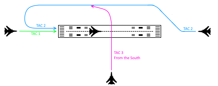 Transporter Tactical Approach
Additionally there are Transporter Tactical Approaches called TAC 1, TAC 2, and TAC 3 which can be seen in the picture of the right.They are designed to make the approach direction of a transporter less predictable by changing between TAC 1, 2 and 3. TAC 1 is basically the straight-in approach. TAC 2 is just like a circling approach and TAC 3 an approach orthogonally to the runway. TAC 3 has two directions it can approach from so additionally North, South, East and West should be added to specify which direction is used
Special Activities
Operation of aircraft arresting systems
There are 2 types of runway arresting systems used for different purposes.
- Aircraft Arresting Cables: Primarily used for tactical military aircraft, such as fighter jets and attack planes fitted with a hook.
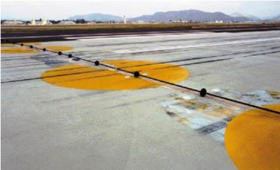
- Aircraft Arresting Barriers: Also primarily used for tactical military aircraft
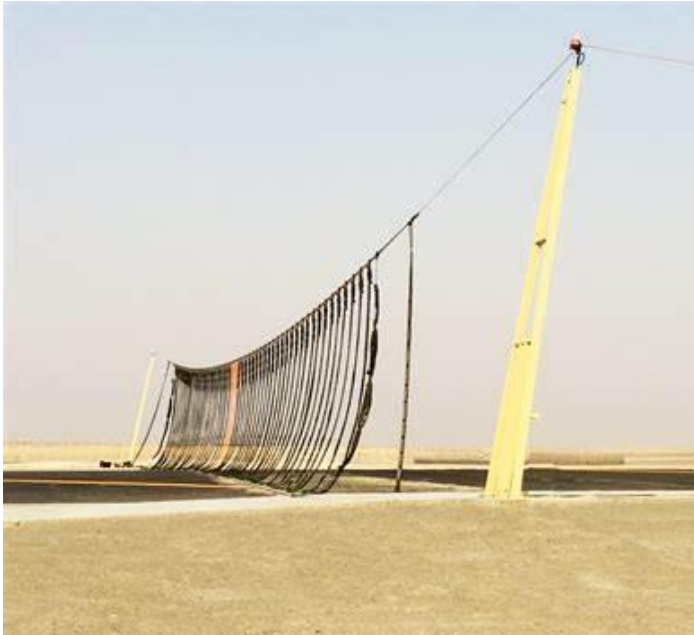
Normally, the barriers will be maintained in the down position. When the barrier has been raised for any emergency situation or if the barrier is under maintenance in a raised position, all take-off must be stopped.
Another Example
Below you find an example IFR flight from initial call to handoff to the military radar. We assume the pilot has filed a flight plan which he should do.
| Station | IFR from startup to departure |
| GAF123 | ETNT_TWR, GAF123, Moin |
| ETNT_TWR | GAF123, ETNT_TWR, Moin |
| GAF123 | GAF123, request taxi |
| ETNT_TWR | GAF123, taxi to holding point runway 26, QNH 1013 |
| GAF123 | GAF123, taxi to holding point runway 26, QNH 1013 |
| During Taxi ETNT_TWR calls EDWW_W_CTR | |
| EDWW_W_CTR | Moin |
| ETNT_TWR | Moin, ETNT_TWR, request clearance for GAF123 |
| EDWW_W_CTR | GAF123 is cleared to Schleswig via EMPIT, squawk 2116 |
| ETNT_TWR | GAF123 is cleared to Schleswig via EMPIT, squawk 2116 |
| EDWW_W_CTR | correct |
| Back on frequency | |
| ETNT_TWR | GAF123 report ready to copy clearance |
| GAF123 | GAF123, ready |
| ETNT_TWR | GAF123, cleared to Schleswig via NT126 left turn EMPIT, squawk 2116, when airborn contact ETNT_APP on xxx.xxx |
| GAF123 | GAF123, cleared to Schleswig via NT126 left turn EMPIT, squawk 2116, when airborn contact ETNT_APP on xxx.xxx |
| ETNT_TWR | GAF123, readback correct |
| Pilot reaches runway and performs pre-departure checks. After pre-departure checks | |
| GAF123 | GAF123, ready |
| ETNT_TWR | GAF123, line up runway 26, wind 25005kts |
| GAF123 | GAF123, line up runway 26 |
| Meanwhile on the phone... | |
| EDWW_W_CTR | Moin |
| ETNT_TWR | Moin, request departure release for GAF123 |
| EDWW_W_CTR | GAF123 released to climb FL70 |
| ETNT_TWR | GAF123 released to climb FL70 |
| Back on frequency | |
| ETNT_TWR | GAF123, climb FL70, wind 25005kts, runway 26 cleared for takeoff |
| GAF123 | GAF123 climb FL70, wind 25005kts, runway 26 cleared for takeoff |
| After take off | |
| ETNT_TWR | GAF123 contact Wittmund Radar on 123.125 |
| GAF123 | GAF123 contact Wittmund Radar on 123.125 |
After this the Radar will identify the aircraft before handing the aircraft over to the responsible DFS station.
Military Radar
Reference Documentation
Charts and Maps for German Military airfield and Airspace can be found on the Mil AIP (www.milais.org)
Airspace
Currently, our SOPs contain little knowledge to military sectors. Therefore, this guide will describe the general concept of military Radar airspaces.
 Rostrock/Lage Airport - © openflightmaps.org
We will start with Rostock Laage. As you can see, the airport has a D-CTR just like all other airports in Germany. Additionally, the airport has a lowered airspace E around the CTR. Almost all military airports have that. The horizontal boundary of the area of responsibility of the Radar coincides with the lowered E airspace. The horizontal boundary is 5500ft. Below 5500 ft and inside that lowered E, the radar controller is responsible for the IFR traffic. As always in airspace E, VFR may enter the airspace without contacting ATC.
Two more examples of this are Diepholz and Wittmund. Just like in the previous example, the vertical limit of the area of responsibility of the military Radar is 5500ft. The horizontal limit coincides with the lowered airspace E. In case of Wittmundhafen, the area of responsibility is the inner rectangle of the TMZ. With this knowledge you can estimate how big the area of responsibility of any military radar is. The upper limit is 5500ft in most cases. The actual area of responsibility can be found in the military AIP (MILAIP, AD2, Minimum vectoring altitude/Area of responsibility chart for each airport).
General Controlling
In general the military Radar has the same responsibility as a typical APP controller. However, you have to remember that you are working with high performance military aircraft and possibly VFR aircraft that call for FIS. In this case you should not rely on visual separation alone as the closing speeds of a 300kt military jet and a 80kt VFR aircraft is too great to simply ignore. In this case working with vertical separation is the easiest solution.
In general military Radars seldom work with procedures. They mostly use headings and altitudes. Speeds are also avoided. VFR and IFR departures are possible. If the pilot departs IFR, he will be handed over to the responsible DFS controller fairly early due to the low airspace boundary. If the pilot departs VFR, he has to follow the VFR departure route which can be found in the Military AIP (VAD). Every deviation from the departure route has to be requested by the pilot and approved by ATC ("request to leave CTR on top").
If the aircraft is arriving IFR, it will be handed over from Center descending FL70 and as early as possible. The aircraft should be released for descent by Center before handoff to allow the Radar controller to control the aircraft. The pilot may decide if he prefers to land VFR or IFR. VFR the arrival is done on TWR frequency as published in the VAD charts (overhead approach maneuver as described below). Sequencing is then done using traffic infos and by telling the pilot which number he is in the sequence.
| Station | Example Flight with IFR Cancellation on entry |
| GAF123 | ETNL_APP, GAF123, 5000ft |
| ETNL_APP | GAF123, ETNT_APP identified, weather code BLU, runway 27, QNH1013 |
| GAF123 | GAF123 blue, runway 27, QNH1013 cancelling IFR |
| ETNL_APP | GAF123, IFR cancelled at 45z, proceed to Entry South 27 |
| GAF123 | GAF123, IFR cancelled at 45z, proceed to Entry South 27 |
| ETNL_APP | GAF123, contact ETNT_TWR 118.425 |
| GAF123 | GAF123, contact ETNT_TWR 118.425 |
| On TWR frequency | |
| GAF123 | ETNL_TWR, GAF123, proceeding to entry south |
| ETNL_TWR | GAF123, ETNL_TWR, enter CTR via Entry South 27 |
| GAF123 | GAF123, enter CTR via Entry South 27 |
| Over Entry South | |
| GAF123 | GAF123, Entry South 27, 1700ft |
| ETNL_TWR | GAF123, ETNT_TWR Roger, report initial, number 2 following EUFI on downwind 27 |
| GAF123 | GAF123, wilco |
If VFR arrivals aren't possible then the military jet will be vectored to procedure and it will fly a PAR, ILS, TACAN, NDB or RNAV approach but without the procedures as described below.
Lastly, we will discuss IFR pickups. IFR pickups are mainly used for military aircraft that enter the area of responsibility of the Radar controller with the intention to land IFR. Departing traffic to leave will already receive the clearance on ground. IFR pickups for military aircraft are much simpler than what you usually do for civil aviation. You just have to make sure that the jet is above the MVA, that it has been assigned a HDG and an altitude (or you have assign either or both during the IFR pickup) and then you say "IFR starts now" and that's it. You should also include the clearance limit (e.g. "cleared to Schleswig") but that is often left out in real life. If you give a IFR pickup for an aircraft that is leaving your sector, you need to coordinate an actual IFR clearance with the DFS station. However, if necessary you can start IFR immediately (mind the MVA) and coordinate the clearance with the DFS station later.
Departures
Unrestricted Climb
An unrestricted climb may be authorized for such reasons as noise abatement, fuel conservation, reduction of icing, or elimination of traffic conflicts. An unrestricted climb is authorized to climb directly to a cruise/enroute altitude without an interim stop. Unrestricted climbs leading outside of the AOR of the Approch controler need to be coordinated withe neighboring sectors.
Instrument Approaches/Procedures
In general military airfields tend to have a mix of ILS, NDM (DME), TACAN (DME) and RNAV approaches. However, most do not have an ILS. Instead the Precision Approach Radar (PAR) is used as a precision approach. However, that is not an instrument approach and thus will be explained in a later chapter.
As mentioned before, instrument approaches are mainly used without the procedure. Most military procedures include a DME Arc and then the familiar final approach. The waypoints on the procedure usually don't have a name so if you want to clear someone to fly the approach via the procedure, it's best to use the terms "Initial Approach Fix" (e.g. "out of IAF cleared TACAN rwy 27") or in general just explain to the pilot what you want him to do (e.g. "Join 12 DME Arc of TACAN rwy 27, cleared TACAN approach runway 27"). That is not quite the way they do it in real life but it will probably work well enough on Vatsim.
In general though it is enough to vector the aircraft to the final approach track and clear them for the approach. Remember that these are non precision approaches so the intercept must be done before the FAF and on the published altitude. You should also make sure that the aircraft has 2NM of straight and level flight before initiating the descent.
Ground Controled Aproches
A ground-controlled approach (GCA) is a service provided by air-traffic controllers to guide aircraft safely during landings, especially in adverse weather conditions. It relies on primary radar images. There are two main types:
- Surveillance Radar Approach (SRA): Offers non-precision surveillance radar approaches without glidepath guidance
- Precision Approach Radar (PAR): Provides both vertical and horizontal guidance for precise landings.
In Germany the GCA Position is known as "Precision", only in Ramstein and Spangdahlem they are called by GCA.
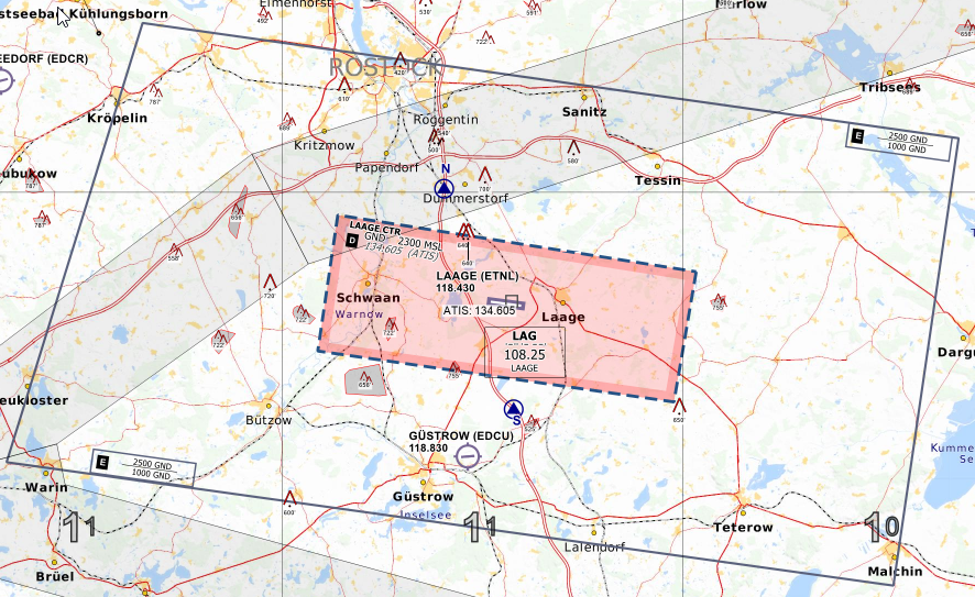
Surveillance Radar Approach (SRA)
In this approach the pilot is provided with instructions and information on the aircraft's location relative to the extended centerline and distance from touchdown. During this approach there should be only one aircraft on frequency. If you ever need to give an SRA during operations with multiple approach controllers, you can let the feeder handle the SRA while the arrival controller handles all other traffic as usual.
In general the procedure for the controller is:
- The pilot needs to be told when the SRA terminates before beginning the descend and the OCA ("This will be a SRA approach, runway 25 terminating at the missed approach point, OCA 840ft, check your minima")
- The final turn onto the runway heading should not be more than 30° and there should be sufficient time before the start of the descent
- The pilot needs to be warned prior to descent ("11NM from T/D, 1NM prior to descend")
- The pilot does not read back the altitudes. He only confirms with his callsign.
- The pilot needs to be told when to initiate the descent ("10NM from T/D, commence final descent now")
- The pilot needs to be informed about the altitude each mile ("7NM from T/D, altitude should be 2500 feet")
- The pilot needs to receive heading adjustments when necessary or otherwise be told that the heading looks good ("left heading 245" or "heading is good"). Heading adjustmens by 1 degree should be avoided.
- At 4NM the pilot needs to be reminded to check gear down ("4NM from T/D, altitude should be 1600ft, remember OCA 840ft, check gear down locked")
- From 4NM to T/D transmissions should not be interrupted by more than 5 seconds.
- The pilot needs to be reminded one mile before approaching OCA ("2NM from T/D, altitude should be 1000ft, approaching OCA, report field in sight")
- Between 2NM and T/D altitude and heading instructions should be given each 1/2 NM.
- If pilot reports field in sight he can be transferred to TWR or can be given the landing clearance after coordination between APP and TWR
- If the pilot does not report the field in sight, ATC should remind him to go around or continue visually ("passing MAP, continue visually or go around" or "go around, follow published missed approach procedure")
Precision Approach Radar (PAR)
The PAR is very similar to the SRA but with better radar equipment to provide precise guidance. That's why it is considered a precision approach. If you have the ground radar plugin and its approach path function available for your airport, you can provide more accurate guidance to undertake such an approach.
The main different to the SRA is that the controller does not stop talking so there is no time for the pilot to confirm any instruction. ATC continues talking until the threshhold of the runway.
If you want to get an idea watch this video.
You will notice in this video that in addition to heading instructions, ATC also gives information about the position of the aircraft in relation to centerline ("right of centerline", "correcting" etc.) and glide path ("below glide path" etc.) while in the SRA ATC only gives headings and recommends an altitude.
Precision Radar Screen
Special Activities
Alert aircraft (QRA).
Once the QRA aircraft are (is) airborne, they have the highest priority and their course must be cleaned horizontally and vertically. The handover to the GCI controller must be coordinated at the earliest in order to facilitate the interception.
Simulated Flameout (SFO) and Emergency Landing Pattern (ELP)
At locations where SFO/ELP maneuvers are conducted, the facility air traffic manager must issue a letter of agreement with the appropriate military authority and adjacent facilities as required. The letter of agreement must include at least the following issues:
- A complete description of the SFO/ELP procedure. (High-key altitude MSL, airspeed during procedure, direction of turns, and low-key altitude MSL will be obtained from the military for all types of aircraft planning to utilize this procedure. The SFO/ELP maneuvering airspace area should be visible from the normal local control position in the control tower.)
- The weather conditions that must exist before issuance of approval by the tower. (Ceiling must be at least 1,000 feet above the approved high-key altitude, and flight and ground visibility must be reported to be at least 5 miles.)
- A statement to the effect that a practice SFO/ELP may be disapproved because of traffic or other reasons either before or after the start of the maneuver.
- A statement that a practice SFO/ELP will be approved only between sunrise and sunset.
The peculiarity of this procedure is that the aircraft has the engine at IDLE and descends with a very high vertical speed and because of that, once authorized and started it should NOT be interrupted.
During this phase, the controller must regulate all traffic according to the current simulated shutdown procedure, ensuring that its trajectory remains clear at all times.
TRAMON
General
TRAMON (short for TRA monitor) is a position used to monitor traffic performing manoeuvres within a restricted area (e.g. TRA). This position is a special working position and does not involve tactical control services. In contrast to the tactical control service of Loneship and Sunrsie, TRAMON is staffed by civil ATCOs.
Positions
TRAMON can be staffed on Vatsim as ETXX_TRA_CTR (130.510)
Tasks
When staffed, TRAMON has the following tasks:
- Activation and deactivation of TRA, as coordinated with the airspace users
- Coordination of TRA opening and closure with the relevant ATC positions
- Clearance to enter or exit a TRA, in coordination with the relevant ATC positions
- Information for traffic within a TRA when the required distance to the area boundary is about to be lost
- Coordination with the relevant ATC positions when traffic within the TRA cannot maintain the required distance to the area boundary
- Traffic information about other traffic inside or crossing the TRA (as far as possible)
- Takes over further tasks such as tanker missions (AAR) and formation splits or formation join-ups
In some cases, TRAMON can also take departing traffic from a military airfield directly, if this traffic requests to enter the TRA directly after departure. This needs to be coordinated with the relevant ATC positions.
TRAMON will not perform any Fighter Control (FC). For this, the stations Loneship (ETXX_LS_CTR) and Sunrise (ETXX_SR_CTR) shall be used, which require a Tier 2 endorsement to be staffed. When Loneship or Sunrise are online, they will perform the TRAMON tasks for the area.
Distances to TRA Boundary
- TRA:
- laterally 2.5 NM (If agreed with ATC, TRA traffic does not need to maintain distance to boundary, ATC shall apply 5 NM)
- vertically 1000 ft below FL290, 2000 ft above FL290 (500 ft if division level in between to FLs, e.g. FL245)
- MVPA:
- Traffic inside MVPA does not need to maintain distance to the boundary; ATC will apply 5 NM and 1000 ft or 2000 ft
Examples
Example 1 - TRA Entry
This example describes a situation where the IFR cancellation is performed by the ATC sector after coordination with TRAMON. The IFR is cancelled before entering the TRA.
Example: (🎧 = EDWW, 📡 = TRAMON)
🎧: "TRAMON, Müritz."
📡: "Go ahead!
🎧: "Radar Handover, SNAKE, 23 NM, west TAGOB, FL210, for TRA operations."
📡: "Identified, TRA operations approved inbound TAGOB, squawk 7415."
🎧: "Consider!"
The ATC sector will then issue the clearance to enter the TRA to SNAKE on frequency.
Example: (🎧 = EDWW, 👨🏻✈️ = Pilot)
🎧: "SNAKE, report flight conditions."
👨🏻✈️: "SNAKE, VMC"
🎧: "SNAKE, IFR cancelled 1235, cleared to operate BASIC1A, 1B, 1C, 1D, FL100 up to FL320, squawk 7315, contact MONITOR <frequency>."
Example 2 - TRA Entry
This example describes a situation where the IFR cancellation is performed by TRAMON. In this case traffic TRAMON will state the entry conditions before traffic is cleared into the TRA.
Example: (🎧 = EDWW, 📡 = TRAMON)
🎧: "TRAMON, Müritz."
📡: "Go ahead!
🎧: "Radar Handover, MMF41, 28 NM, south KUBAB, FL260, for air to air refuelling JANIN anchor."
📡: "Identified, Heading 350, descend to FL220, squawk 7432."
🎧: "Consider!"
TRAMON will then issue the IFR cancellation.
Example: (📡 = TRAMON, 👨🏻✈️ = Pilot)
👨🏻✈️: "TRAMON, hello, MMF41, heading 350, FL220"
📡: "MMF41, identified, report flight conditions."
👨🏻✈️: "MMF41, VMC"
📡: "MFF41, IFR cancelled 1235, cleared to operate BASIC1A, 1B, 1C, 1D, 1E, FL100 up to FL320, enter JANIN anchor FL220."
Example 3 - TRA Exit
TRA exits can be performed in several ways. Either the traffic requests to leave the TRA VFR into airspace E, or traffic can leave IFR. When leaving IFR, TRAMON coordinates the IFR clearance with the relevant ATC sector or issues a frequency change to the ATC sector (free call).
The following example describes a situation where TRAMON coordinates an IFR clearance with the ATC sector.
Example: (🎧 = EDWW, 📡 = TRAMON)
📡: "Müritz, TRAMON."
🎧: "Go ahead!
📡: "Radar Handover, SNAKE, squawking 7315, position 15 NM east of LAG, FL185, request IFR clearance to ETNS."
🎧: "Identified, cleared to ETNS via direct SWG, FL180, squawk 1132, IFR starts now."
📡: "<readback>"
TRAMON will then issue the IFR clearance to the pilot and transfers the aircraft to the next ATC sector.
Example 4 - TRA crossing with millitary jet aircraft
TRA transits of military IFR jet traffic through an active TRA are often generally approved by TRAMON. TRAMON shall be informed about the crossing traffic in due time.
In general TRA traffic will not be separated to other military jets crossing the TRA (inter-military risk).
Example: (🎧 = EDWW, 📡 = TRAMON)
🎧: "TRAMON, Müritz."
📡: "Go ahead!"
🎧: "Information on TRA crosser, THUNDR1, 2 ship tornado formation 10 miles west of MASOR, FL200, on course to LAG."
Usually, the crossing traffic stays on the frequency of the ATC sector. For these flights a traffic information shall be given, when entering the area.
Example: (🎧 = EDWW, 👨🏻✈️ = Pilot)
🎧: "THUNDR1, you are entering active TRA, traffic information, single Eurofighter, bearing 035, distance 37 NM, indicated FL200."
👨🏻✈️: "TUNDER1, roger, looking out"
TRAMON shall also issue traffic information for traffic inside the TRA as far as possible.
The same procedure shall be applied for civil traffic crossing TRAs on TRA priority airways. Important to note: This traffic needs to be separated to traffic within the TRA (see example 5).
Example 5 - TRA crossing with civil or military transport aircraft
In general, TRAMON shall not approve any TRA crossing for civil or military transport aircraft except for:
- Flights for which an emergency has been declared
- SAR flights
- Medical flights
- Flights avioding dangerous WX phenomena
Traffic crossing the TRA (except military jet aircraft) are required to be separated to traffic inside the TRA. In this case, TRAMON will usually adjust the lowest/highest available level for the TRA usage or block certain TRA sectors until the crossing traffic as passed. Remember that traffic in the TRA is still VFR. Additionally, TRAMON shall issue traffic information about the TRA crosser as far as possible.
Example: (🎧 = EDWW, 📡 = TRAMON)
🎧: "TRAMON, Müritz."
📡: "Go ahead!"
🎧: "Approval request for TRA crossing, due to weather, EJU34BA, A320, 10 NM north of ARGAD on heading 170, FL250, for approx. 25 NM."
📡: "Approved!"
The ATC sector shall then coordinate the further routing with TRAMON once the aircraft is clear of weather again.
Example: (📡 = TRAMON, 👨🏻✈️ = Pilot)
📡: "SNAKE, lowest usable FL260 due to stranger, bearing 025, range 15 NM, FL250, track south."
👨🏻✈️: "SNAKE, copy, lowest FL260"
Military Enroute
The Following Page have been kindly provided by Virtual NATO.
Reference Documentation
Charts and Maps for German Military airfield and Airspace can be found on the Mil AIP (www.milais.org).
Formation Flights
Formation flights shall be controlled/cleared as a single aircraft unless the formation leader requests otherwise.
Radio communication flow is strictly between the formation leader and the controller. The controller should expect a radio roll call from all wingmen before being contacted by the leader (i.e: "NATO11 check... 12... 13... 14. SUNRISE, NATO11").
Should a call be addressed to a specific wingman, the controller must use the aircraft callsign including the sequence number. (i.e: "NATO13 SUNRISE squawk normal").
The responsibility for separation between elements of a formation flight rests with the pilots in the formation: Military Authority Assumes Responsibility for Separation of Aircraft (MARSA).
Enroute
Radar Control
When the controller has positively identified the aircraft (Position, heading, altitude, Squawk), he will take the responsibility of the its safety with this procedure:
[ (aircraft callsign) [RADAR] IDENTIFIED, [(number) DEGREES (number) MILES (Ref Point)], [SQUAWK (number) ],
Instructions or information if the aircraft was flying at a different type previously (i.e. climbing from low level)
[ YOU ARE NOW IN IFR (or OAT INDIA or TANGO)]
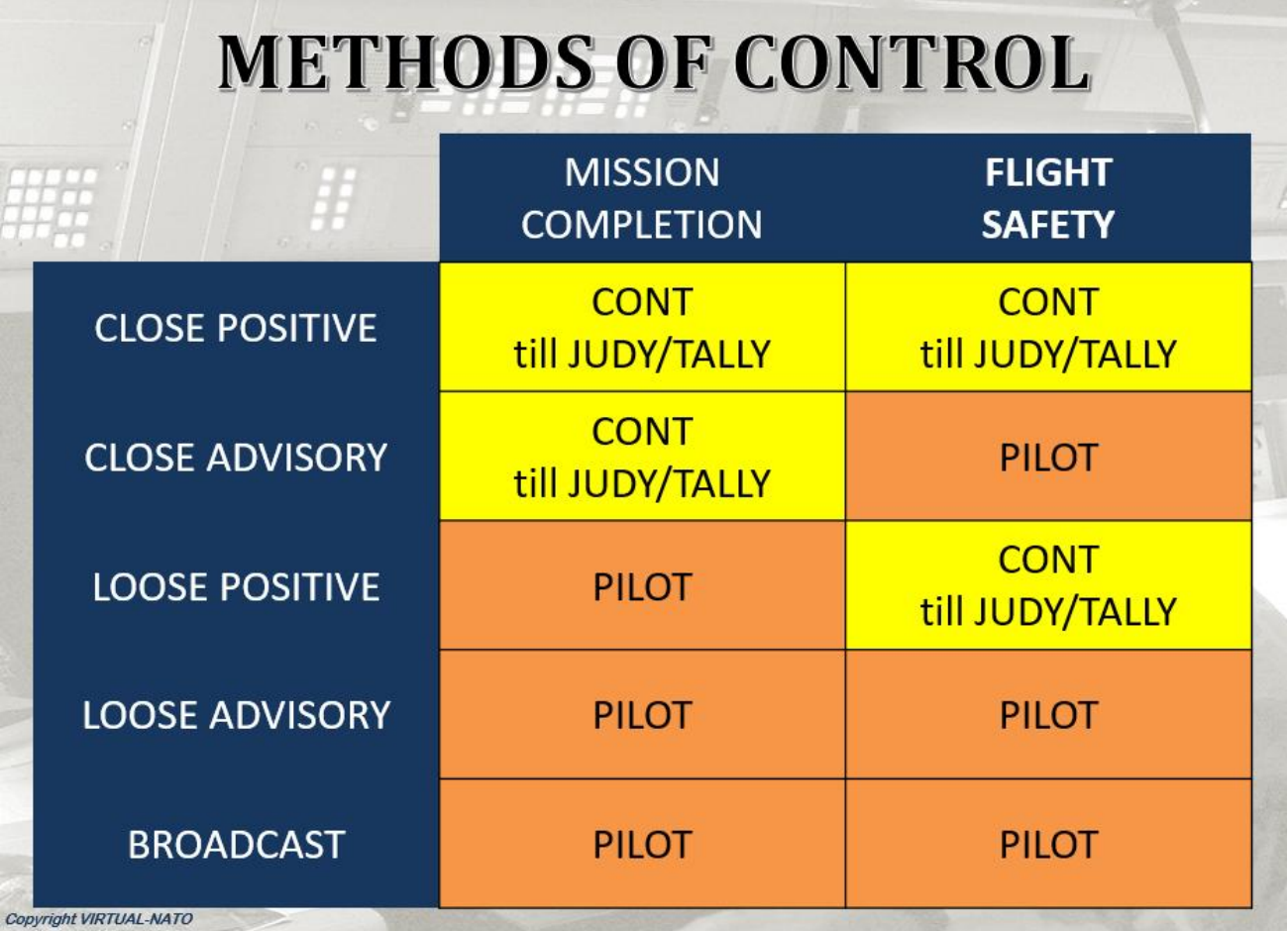
Methods of Control
The method of control is the concatenation of 2 criteria:
- The type of control which determines the responsibility for the mission completion.
- The level of control which determines the responsibility for flight safety.
Types of control
There are 3 different types of control, which can determine how the mission is conducted:
Close Control
In a close control sortie, controllers are responsible for mission completion. During Enroute sortie in OAT IFR, pilots must follow and execute all controller’ commands.
Loose Control
In a loose control sortie, the controller transmits only information to the pilot, with no commands. Pilot is responsible for the mission completion. Broadcast Control. The controller will transmit general information and activity within the designated area in the form of
Broadcast
The format of the broadcast will depend on the tactical situation. Pilot is responsible for the mission completion.
Levels of control
There are 2 different levels of control, which determine the level of responsibility for safety.
Positive Control
Under Positive control, the controller is responsible for keeping the safety separation:
- Between all aircraft he is controlling (except within formations),
- From strangers
Advisory Control
All Flight Safety and separation actions are the responsibility of the pilot.
Change flight type or control method inflight
Change Flight type.
When the mission requires, aircraft or formation may request to change the flight type. For example, a Reconnaissance (RECCE) mission will start the mission in High Altitude under OAT IFR and descend later in low level to approach the target before climbing again to high altitude for recovery. Changes must be clearly stated on the frequency to transfer the responsibility to pilot/controller.
Pilot Request:
[ REQUEST TO CHANGE FOR OAT TANGO [or VICTOR or INDIA] [VMC (or IMC)] [(significant point or area) FROM (level) TO (level)] [TO (time or significant point)] ]
Controller Reply:
[ YOU ARE NOW IN OAT TANGO [or VICTOR or INDIA] [SQUAWK (code)]
[REPORT END OF WORK (or significant report point) if required ]
If end of work
Pilot message:
[ END OF OAT TANGO, REQUEST TO RESUME (or TO CHANGE) OAT VICTOR [or INDIA] ]
Controller reply:
[ YOU ARE NOW IN OAT VICTOR (or INDIA) ]
Every change of method of control must be clearly stated on the frequency.
Pilot request:
[ REQUEST CLOSE (or LOOSE) POSITIVE (or ADVISORY) CONTROL ]
Controller reply:
[ CONTINUE IN OAT VICTOR, BROADCAST (or ADVISORY) CONTROL ]
Mixed flight OAT/GAT/OAT
A "mixed" flight is a flight with alternating phases of flight conducted in General Air Traffic (GAT) and Military Air Traffic (OAT).
For operational reasons, the mixed flight plan may be used in the following situations:
- AEW aircraft proceeding to the orbit area in GAT and switching OAT during the On Station (or vice versa)
- AR tanker proceeding to his Air Refueling area
- Aircraft departing OAT and going abroad or coming back from abroad
The mixed flight plan is treated twice, one for the GAT part and the other for the OAT part. It is crucial to carry out the task with the utmost care, as this could lead to errors during the flight plan's computer processing and result in its rejection.
Mixed flight is specified in field 18 under RMK/ MIXED GAT OAT or MIXED OAT GAT as applicable.
The change of flight rule shall occur over the Transfer Point : Fix in GAT or WP in OAT. Controllers should proceed to the frequency change 1 minute before the aircraft reaches the XFER point at the latest.
Special Activities
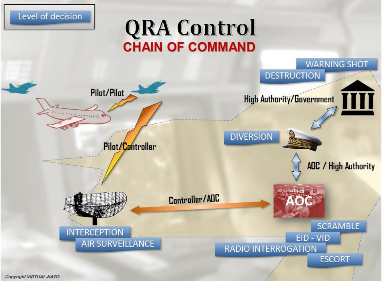
QRA (Quick Reaction Alert)
In accordance with SOP PPM and the LOA between vNATO and VATGER, the Enroute controller online can either scramble the QRA (if any available or planned) or divert an airborne vNATO asset to intercept an aircraft that is not respecting the VATSIM rules (no FPL, no radio contact etc...).
The vNATO pilot shall mention “AIRBORNE ALERT CAPABLE” if he is qualified QRA. Squawk assigned to QRA are:
- QRA A7400
If the controller is GCI qualified, he is allowed to provide CLOSE POSITIVE control to perform the interception at the fastest and best conditions.
If the controller is not GCI qualified, he can only provide LOOSE POSITIVE control to perform the interception.
He will provide the fighter pilot with the target position using ground geographical reference or the fighter/target relative position (bearing & range) along with available details (altitude, aspect). The success of the interception relies only on the fighter pilot
Control sequence:
Take-over after Scrambled mission:
Pilot: [ SUNRISE, NATO XRAY ]
Controler: [ NATO XRAY, SUNRISE, RADAR CONTACT, LOOSE POSITIVE, TURN RIGHT (or LEFT) HEADING (number), CLIMB [FLIGHT] LEVEL (number) ]
If no target assigned:
Controler: [ YOU ARE ON AIRBORNE ALERT, HOLDING POINT AS FRAGGED ]
If (or when) an target is assigned:
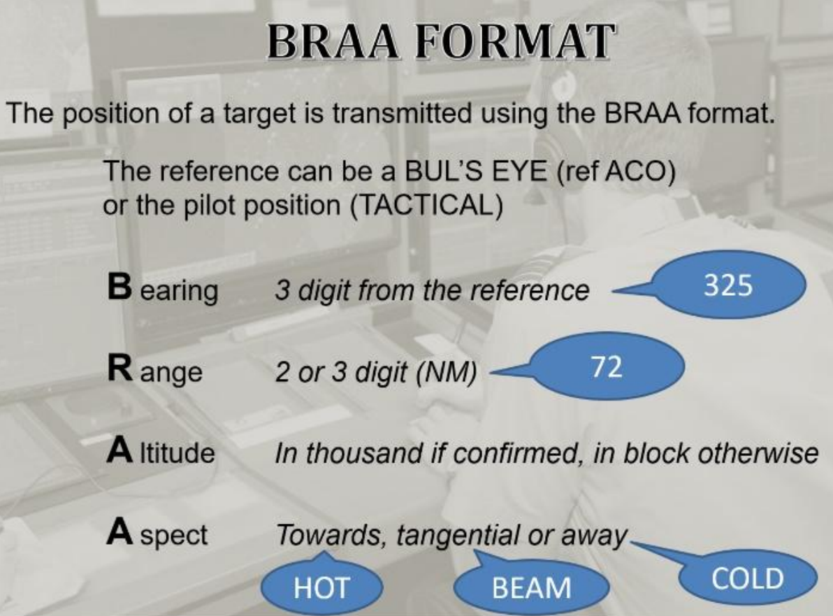
Controler: [ YOUR TASK IS QRA INTERCEPT (or AIR POLICING) ON A TARGET CLASSIFIED (classification), BRAA (number), PRESUMED FORCE (number), SQUAWKING (number), CHECK WEAPONS SAFE ]
Target amplifying information:
[ TARGET CLASSIFIED (classification) BRAA (number), STRENGTH (number), SQUAWKING (number) ]
Work in reserved airspace
Aircraft intending to perform air maneuvers will proceed to a booked area (TRA, TSA, Restricted or Dangerous). They may join the area in GAT IFR, OAT IFR or VFR. When reaching the area, they change type to OAT T (Tactical).
For mor information visit --> Restricted Areas
Airborne Early Warning & Electronic Warefare
The control of EW or AEW assets is limited to providing situational awareness outside the working area assigned to the assets. Once they are ON STATION on their assigned orbit, they are prioritized in their airspace (booked area and altitude block).
AEW / EW Control procedure:
- Ask the pilot to confirm the working Level [ REPORT ORBIT (FLIGHT) LEVEL ]
- Clear the aircraft to climb/descent at Orbit level [ CLIMB (or DESCEND) ORBIT LEVEL (number) ]
- Ask the pilot to advise when On Station [ REPORT ON STATION ]
- Assign squawk [SQUAWK A7423 or 24]
- Ask the pilot to advise when Off Station [ REPORT OFF STATION ]
Note: EW and AEW assets transmit high power microwaves, therefore it is forbidden to allow any aircraft to fly close unless the equipment is switched off.
Aircraft Captain must be requested the authorization for any kind of interception.
Supersonic Flight
Supersonic speed flights over German territory are only allowed if at least one of the following conditions is met:
- Within the Supersonic Area over the north sea.
- Above FL360.
Formation Flights
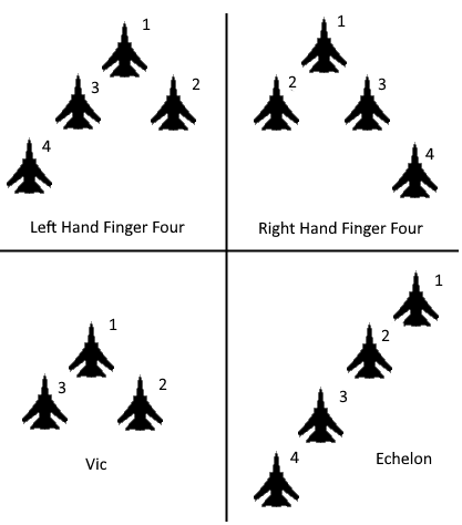
It is very common for military jets (e.g. F-16, F-18) to engage in formation flying. In these formations the responsibility for separation lies with the pilots. Some notable examples of formations are the Four Finger Formation, the Echelon Formation and the Vic Formation depicted on the right. These formations can be formed by at least two aircraft, however, there is no upper limit for the amount of aircraft in one formation.
 Formations
All aircraft in a formation usually have similar callsigns. If the military aircraft are using airforce callsigns then the flight leader will be numbered GAF123A and all other aircraft GAF123B, GAF123C etc. The flight leader will use the callsign GAF123 Formation when talking to ATC. If military aircraft are using tactical callsigns they will be numbered SABRE1, SABRE2, SABRE3 etc. The flight leader will use the callsign SABRE Formation when talking to ATC. No matter which callsign is in use, inside the formation the pilots will only refer to each other by using numbers as depicted on the right.
For ATC formations are handled like a single aircraft. Only the flight leader will have the transponder turned on and only he will communicate. You as ATC can disregard all other aircraft inside the formation. However, due to the fact that formations take up more space than single aircraft, we have to increase the horizontal separation from other aircraft to formations by one additional mile.
All Approaches and Departures can be flown by formations. That means that it is possible for formations to depart or land as a formation. In that case the runway needs to have a width of 45m for departure and 120m for landing. During the previously mentioned "Overhead Approach Maneuver" the formation will split automatically without any need to interfere by ATC.
Although only the flight leader will communicate with ATC, all elements of the formation have to listen on the active frequency. That means when the formation switches the frequency, there will be a short check by the formation when switching frequency as shown in the example below.
| Station | Phraseology during frequency change |
| EDGG_GIN_CTR | GAF123, Contact Bremen Radar on 123.125 |
| GAF123A | GAF123 Formation, Contact Bremen Radar on 123.125 |
| After frequency change on frequency 123.125 | |
| GAF123A | GAF123 Formation, check |
| GAF123B | Two |
| GAF123C | Three |
| GAF123D | Four |
| GAF123A | Bremen Radar, GAF123 Formation FL220 |
Formation Splits
Reasons for formation splits can be operational reasons, weather or because formation landings are not possible. Especially in case of weather it is possible that elements of the formation lose visual contact with their wingmen. This is an emergency situation and must be resolved immediately. Most of the time the pilot will initiate the split and announce the emergency on frequency.
Plainly said: To split a formation one only needs to assign any instruction that will separate an aircraft from the formation. In case there are multiple aircraft, the split has to be performed one aircraft at a time! Methods to split the formation are
- Longitudinal split by using speed adjustment
- Vertical split by using climbs/descends
- Lateral split by assigning different vectors
- Combinations of the above.
Formations are only performed on request of the pilot(s). In IMC the split should not be performed in turn or descent unless requested so by the pilots. For ATC it is very important to know if the aircraft, that needs to be split from the formation, is able for a certain type of split. You do not need to know where every aircraft in the formation is but you need to ask whether the formation is able for a split turn or any other split. For example, when the splitting aircraft is on the right side of the formaiton, a left turn split will not be possible unless the pilot is given enough time and warning to move to the left side of the split. Especially when requesting a split by turning, the pilot should report which direction they are able to turn to.
The Formation split is considered accomplished when the pilot reports having passed or reached a level that is sufficient to provide vertical separation. The identification of the aircraft that is split from the formation should be done as soon as possible and before radar separation is established. Below you find examples and explanations for the three ways a formation split can be performed
Longitudinal Formation Split by Speed Adjustment
For a Formation Split by speed adjustment you have to know the indicated airspeed of the formation. You can then assign a speed to the aircraft that needs to be split from the formation. Make sure that it is a significant speed different (e.g. 60 kts) because otherwise the split takes unnecessarily long. In this case you do not need to know the positions of the aircraft within the formation as it is not relevant for this type of split.
 Split by Speed Adjustment
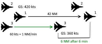
As you can see in the picture, the number three, GAF123C, is assigned a 60kts speed difference. With 60 kts it takes 6 minutes to reach the required 6NM horizontal separation (5NM plus 1 NM because it is horizontal separation to a formation). This takes 42 NM without taking the decceleration period into consideration. As you can see, this should only be performed if enough flying distance is available. Especially when another split needs to be performed between one and two, this will take another 42NM. Below you can find an example for the phraseology with three aircraft in the split, GAF123A, GAF123B and GAF123C.
| Station | Longitudinal Split by Speed Adjustment |
| GAF123 | GAF123 Formation, request split for individual approaches, C is number one |
| ATC | GAF123 Formation, report indicated airspeed and ready for split by speed |
| GAF123 | GAF123 Formation, speed 300kts indicated, ready for split |
| ATC | GAF123 Formation, for split maintain speed 300 kts, GAF123C, reduce speed 240 kts |
| GAF123 | GAF123 Formation maintaining speed 300 kts, GAF123C reducing speed 240 kts |
| ATC | GAF123C squawk 2114 |
This may be repeated for GAF123B in order to complete the split.
Vertical Formation Split
This is generally the fastest way to achieve the formation split. It takes only about 5 NM to achieve radar separation in this case. However, it also results in two aircraft on top of each other that will need to get individual approaches which can unnecessarily complicate the traffic situation in an approach airspace. In this case you do not need to know the positions of the aircraft within the formation as it is not relevant for this type of split. The Phraseology example is again given for a formation with three aircraft, GAF123A, GAF123B and GAF123C. This time we will also split GAF123B. The formation is flying on FL170.
| Station | Vertical Split |
| GAF123 | GAF123 Formation, request split for individual approaches, C is number one |
| ATC | GAF123 Formation, report ready for split by descent |
| GAF123 | GAF123 Formation, ready |
| ATC | GAF123C for split descend FL150, report passing FL 160 |
| GAF123C | GAF123C descending FL150, report passing FL160 |
| ATC | GAF123C squawk 2114 |
| GAF123C | GAF123C squawk 2114 |
| ATC | GAF123C identified |
| GAF123C | GAF123C passing FL160 |
| ATC | GAF123C Roger, GAF123 Formation, report ready for split by descent |
| GAF123 | GAF123 Formation, ready |
| ATC | GAF123B for split descend FL160, report reaching FL 160 |
| GAF123B | GAF123B descending FL160, report reaching FL160 |
| ATC | GAF123B squawk 2115 |
Lateral Formation Split
In this case the time it takes to split the formation depends on the angle between the aircraft that is split from the formation and the formation. Generally a 20-40° angle between formation and splitting aircraft is advisable. In this case it takes 16 NM to reach 6NM horizontal separation with a 20° angle, 11 NM with a 30° angle and 8NM with a 40° angle. Any angle above 40° does not significantly increase the distance it takes to perform the split and achieve the required spacing. Again the previously mentioned example is given below. This time it is very important that ATC knows where the aircraft are inside the formation. Of course it is also possible to use orbits and "three-sixties" to accomplish a split but that is not recommended at high speed or high levels.
| Station | Lateral Split |
| GAF123 | GAF123 Formation, request split for individual approaches, C is number one |
| ATC | GAF123 Formation, report position of C |
| GAF123 | GAF123 Formation, C is on the right hand side |
| ATC | GAF123 Formation, report ready for (right turn) split |
| GAF123 | GAF123 Formation ready |
| ATC | GAF123C for split turn right by 30° |
| GAF123C | GAF123C for split turn right by 30° |
| ATC | GAF123C squawk 2114 |
Another example when a right turn split is not possible but C is on the right hand side.
| Station | Lateral Split |
| GAF123 | GAF123 Formation, request split for individual approaches, C is number one |
| ATC | GAF123 Formation, report ready for left turn split |
| Give time for C to position on the left hand side | |
| GAF123 | GAF123 Formation ready |
| ATC | GAF123C for split turn left by 30° |
| GAF123C | GAF123C for split turn left by 30° |
| ATC | GAF123C squawk 2114 |
Formation Join Up
In some cases aircraft will start individually and form a formation later. This is also necessary when a Jet aircraft joins a tanker formation to perform air to air refueling.
 Vertical Formation Join Up
The following general guidelines need to be considered for a join up:
- the Join Up should be performed in VMC
- especially with limited visibility the join up should be performed vertically. Avoid cleared conflicts at all times!
- The intercept angle between both aircraft should not be greater than 45°
- ATC is required to maintain radar separation until the pilot reports the other aircraft in sight and the join up is approved. From that point onward the pilot is responsible for separation to the aircraft that he is joining up to.
- The formation may only be handled as a formation (handled as if it were one aircraft) when the flight leader has reported "FORMATION TIGHT"
- Before the formation is tight HDG and level changes should be avoided and if necessary only made with the consent of both pilots.
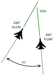
As you can see in the picture on the right, all guidelines are obeyed. The Join up is performed vertically with an intercept angle of a maximum of 45°. There is no cleared conflict. Both aircraft should be vectored to a distance of roughly 3NM before initiating the visual join up to make it easier for the trailing pilot to visually spot the preceding aircraft. Below you find a phraseology example for the formation join up.
| Station | Formation Join Up |
| GAF123B | GAF123B request to join GAF123A |
| ATC | Roger, GAF123A report flight conditions and heading |
| GAF123A | GAF123A HDG030, VMC |
| ATC | GAF123B Fly Heading 355, climb FL 160 |
| GAF123B | GAF123B Fly Heading 355, climb FL 160 |
| When close to 3NM | |
| ATC | GAF123B Alpha is 10 o'clock, 3NM converging, FL170, report in sight |
| GAF123B | GAF123B Alpha in sight |
| ATC | GAF123B approved to join visually, report formation tight |
| GAF123B | GAF123B joining visually, wilco |
| After the formation has been formed | |
| GAF123 | Langen Radar, GAF123 Formation, Formation Tight |
| ATC | GAF123B squawk standby |
Air to Air Refuelling (AAR)
What is Air to Air Refueling (AAR)?
AAR is a procedure established to refuel aircraft midflight and thus enable longer flight time. AAR can be either done on a specified air refuelling anchor or en-route on previously coordinated routes or standard AAR routings. For germany, Air Refuelling Anchors are published in GEMIL FLIP MAP, publicly available here: https://www.milais.org/publications.php.
What are the roles for an AAR?
Tanker: The aircraft used to refuel the receiver(s).
Receiver: The aircraft being refueled by the tanker.
AAR within a published air refuelling anchor.
Air refuelling anchors are predefined procedures, often located within an ED-R/TRA and similar to a civil holding procedure. The conduct of air refuelling within a pusblished air refuelling anchor normally requires four flight levels on top of each other. The lateral and vertical dimensions of the anchor are defined on the respective anchor chart in GEMIL FLIP MAP. Let's look at the GRETCHEN anchor, located within ED-R 207 (TRA Allgäu) as an example:
[CHART NOCH EINFÜGEN]
Laterally, the anchor is defined by the means of four anchor points (AP/TP 1 and 2). Vertically, the anchor extends from FL270 up to FL300.
Use of flight levels within the anchor.
The flight levels within a defined air refuelling anchor shall be used as described here:
FL A: Alternate flight level
The FL above the tanker shall be kept clear for safety actions or exit possibility.
FL B: Refuelling base level
The FL actually used for the refuelling, actual FL of the tanker.
FL C: Entry level of the first receiver(s)
FL below refuelling base level. Used as entry level for the first receiver(s) if no other aircraft is in formation with the tanker. This FL shall be kept clear as long as receiver(s) are in formation with the tanker, used by receivers to descend in an emergency situation.
FL D: Entry level of further receiver(s)
FL below entry level of the first receiver(s). Used as entry level for further receiver(s) if other receiver(s) are already in formation with the tanker.
Separation to and within air refuelling anchor.
Other traffic shall be separated by the applicable radar or vertical separation from the tanker. During tanker formation (tanker and receiver), the radar separation shall be increased by 1 NM. The vertical separation minima shall be maintained above FL A and below FL D.
Within the anchor, the required separation between tanker and receiver shall be maintained until the receiver reports the tanker in sight and has been cleared to change to refuelling frequency (also called "boomer" frequency).
If the anchor is located within an ED-R/TRA, further missions in the area shall be vertically separated by 2000 ft above FL A and below FL D.
Control Procedures for Tanker and Receiver aircraft.
Following control procedures shall be applied for the conduct of AAR:
Tanker aircraft.
After initial contact has been established with the tanker aircraft, the tanker shall be cleared to enter the anchor area:
"(Callsign), cleared to enter GRETCHEN anchor FL290."
When tanker is within the anchor area, the tanker pilot shall inform ATC about flight conditions (IMC/VMC), possible contrails, refuelling frequency and refuelling speed:
"(Callsign), report flight conditions."
"(Callsign), are you trailing?"
"(Callsign), request boomer / refuelling frequency."
"(Callsign), report fuelling speed."
The tanker shall be informed about the number, type and callsign of the receiver(s) as well as the estimated beginning of the rendezvous manoeuvre as soon as possible:
"(Callsign), you receivers are (number) (type), (callsign of receiver), expect rendezvous in (time) minutes."
Receiver aircraft.
If no other receiver are in formation with the tanker, first receivers shall be guided to the tanker at FL C. Further receivers at FL D.
After initial contact, receivers shall be informed about callsign, position, refuelling speed and frequency of the tanker. Additionally, they shall be instructed to check the armament safety (switches safe = all weapon switches set to SAFE/OFF) and air pressure setting.
"(Callsign), tanker call sign is (callsign of tanker), refuelling speed (speed)."
"(Callsign), tanker position is (position), squawking (squawk of tanker), he is (not) trailing."
"(Callsign), check switches safe and altimeter settings standard."
While approaching the anchor area, the receiver shall be instructed to report radar contact with the tanker:
"(Callsign), report radar contact."
Position information about the tanker shall be given at intervals of 10 NM until receiver reports radar contact (also called "Judy").
If radar contact is not reported, the receiver shall be instructed to report visual contact with the tanker:
"(Callsign), report tanker in sight."
As soon as the receiver reports radar or visual contact, he shall be instructed to:
- squawk standby,
- obtain ATC clearance before leaving the refuelling level block,
- in case of visual contact: check nose cold (radar of receiver set to standby),
- establish radio contact with tanker on boomer frequency.
"(Callsign), squawk standby, (check nose cold), for clearance call back on (this) frequency, contact boomer on (boomer frequency)."
Enroute refuelling on standard AAR routings
For the purpose of connecting military aerodromes and exercise areas, enroute AAR routings have been established and are published in ENR 5.2 MILAIP Germany.
[CHART NOCH EINFÜGEN]
These routes are only available in FL210 or FL220, depending on the definition in ENR 5.2 which is complying with the semicircular level assignment rule. The rendezvous points shall be indicated by STAY indicator in FPL, additionally a RMK/ENR REFUELING shall be added in Field 18.
Merging tanker and receiver aircraft shall be handled like a formation joinup.
Refuelling shall not take place before the formation is following the respective AAR routing.
The tanker pilot shall:
- obtain approval before refuelling starts ("request approval to start refuelling.",
- provide information about the actual refuelling status ("currently refuelling"/"currently not refuelling") each time he establishes radio contact with a new sector,
- inform when the actual refuelling is finished ("refuelling finished").
Changes to the route of the refuelling formation shall only be made on request or with the consent of the tanker. Exceptions shall only be made for safety reasons or to give way to flights with higher priority.
Restricted Areas
Types of Restricted Areas
All aircraft operating in restricted airspace should be assigned a dedicated squawk (including formation elements).
An exception is ED-R 150 (Night Low-Flying System), which uses specific squawks for low-level flying (refer to transponder).
Upon entering restricted airspace, aircraft must autonomously or under instruction switch to the tactical frequency (e.g., TRAMON/GCI). If TRAMON/GCI is offline, entering aircraft should monitor the current frequency for traffic information.
ED-R (Restricted Area)
A permanently or temporarily restricted airspace that may only be entered with explicit permission.
Purpose: Protection of security-sensitive facilities, military exercises, major events, or state visits.
Example: ED-R 146 (Berlin) protects government buildings and diplomatic facilities.
ED-D (Danger Area)
An airspace where activities potentially hazardous to aircraft take place. Flight is not strictly prohibited, but caution is advised.
Purpose: Shooting exercises, missile tests, military operations.
Example: ED-D 19A is used for military training missions.:
TRA (Temporary Reserved Airspace)
A flexibly activated airspace reserved for military exercises or special operations.
Purpose: Air combat exercises, aerial refueling, tactical maneuvers.
Example: TRA Lauter (in southern Germany).
Phraseology Examples
Clearance to operate in a TRA |
| G: [Call sign], IFR cancelled, approved to operate TRA [Name], FL100 up to FL300, report finished. Frequency change approved. |
| A: [Call sign], IFR cancelled, approved to operate TRA [Name], FL100 up to FL300, will report finished. |
Clearance to operate in parts of a TRA
In this example, only parts of the area are used, such as BASIC1A and BASIC1B. |
| G: [Call sign], IFR cancelled, approved to operate TRA [Name] part [Parts of the TRA], FL100 up to FL300, report finished. Frequency change approved. |
| A: [Call sign], IFR cancelled, approved to operate TRA [Name] part [Parts of the TRA], FL100 up to FL300, will report finished. |
Aerial refuelling within a TRA
See also Air to Air Refuelling |
| G: [Tanker call sign], cleared to operate TRA Allgäu Gretchen Anchor, on FL200. Report established. |
| A: [Tanker call sign], cleared to operate TRA Allgäu Gretchen Anchor, on FL200. Report established. |
| A: [Tanker call sign], established on Gretchen Anchor. |
| G: [Tanker call sign], report leaving, frequency change approved. |
Entry into ED-R 150 (Night Low-Flying System)
|
| G: [Call sign], Descend altitude (based on the current local QNH) ft (MVA), report cancelling IFR inside ED-R 150. |
| A: [Call sign] inside ED-R 150, cancelling IFR first portion." |
| G: [Call sign], IFR cancelled at (time), contact monitor on (frequency/channel). |
AWACS Orbit
|
| G: [Call sign], approved to operate Orbit NG81, FL300, counterclockwise, report finished. Frequency change approved. |
| A: [Call sign], approved to operate Orbit NG81, FL300, counterclockwise, will report finished. |
Scramble
Officially a "Scramble" is a Security Flight. This can either be an Alpha-Scramble (Actual Scramble) and a Tango-Scrample (Training Scramble). The idea is that a military jet (e.g. multirole combat aircraft, interceptor etc.) on the ground takes off with the goal to intercept another aircraft for defense of the airspace. For ATC the goal generally is to reduce time loss on ground and give the aircraft priority. A-Scrambles have this priority during the entire flight and are the second priority just behind emergencies. T-Scrambles also receive priority (like government flights) but they are a lower priority than A-Scrambles (also lower than Search and Rescue and flights carrying sick/ill passengers).
Remember that A-Scrambles and T-Scrambles are only permitted on VATSIM if all pilots involved are members of a VSO and agree to the procedure.
General notes:
- During Departure ATC is in control of the aircraft, however, especially HDG and level would have to be given from the responsible defense authorities. Otherwise it is a normal military departure with priority.
- Headings are called "Vector" and Flight Level are called Angels -> Vector 050, Angels 22 means HDG 050, FL220
- Enroute the Military jet would be handed over to the responsible defense authority. However, ATC needs to know where the scramble is heading and has to keep all other traffic away from the scramble (maintain separation, especially in case of an A-Scramble!)
- For the return the scramble is again under control of ATC. An A-Scramble is then degraded to a T-Scramble and should be allowed to fly the shortest possible routing.
Fighter Control
Here you will find all relevant Information needed for the GCI Position.
0-Introduction
Diese Seite befindet sich derzeit im Aufbau. Einige der angebotenen Inhalte können unvollständig sein oder Fehler enthalten.
Introduction
This Book will intreduce you to Tactical Fighter Controle used by GCI (Sunrise and Loneship). The Following Pages have been kindly provided by Virtual NATO.
Glosary
|
AEW |
Airborne Early Warning |
|
AR |
Aerial Refuelling |
|
AWACS |
Airborne Warning and Control System |
|
GAT |
General Air Traffic |
|
GCI |
Ground Controlled Interception |
|
MR |
Mission Ready |
|
OAT |
Operational Air Traffic |
|
QRA |
Quick Reaction Alert |
|
TRA |
Temporary Reserved Area |
|
VSOA |
Virtual Special Operation Administration |
Copyright Notice
Material published by vNATO (www.virtualnato.org). These Documents are copyright proprietary of VIRTUAL NATO and may not be reproduced without written permission of the author. Reading these manuals constitutes acceptance of the Copyrights of the Author.
Knowledge of these documents is considered paramount to flight safety on the VATSIM Network.
This is NOT an official AVIATION document. It is used to Support and Teach private Persons and flying Enthusiasts to have a good knowledge base of Flying in Simulated Environments.
VirtualNATO.org is in NO WAY affiliated with NATO.int or any real world NATO organisation/companies related, therefore, WE are a stand-alone, non-profit virtual organisation of flight simulation enthusiast, a group of friends with the common interest in promoting enjoyment and education through the simulation of military operations and procedure through the use of operating standards within several flight simulation platforms as VATSIM
Virtual NATO Military Committee
Virtual NATO Staff
1-Types & Methods of Control
Diese Seite befindet sich derzeit im Aufbau. Einige der angebotenen Inhalte können unvollständig sein oder Fehler enthalten.
Introduction
This module describes the different types and levels of control, then the methods used by Fighter controllers. After completion of this module, you will be able to:
- State the different types of control.
- State the different levels of control.
- State the methods and responsibilities during an AD mission.
Types and levels of control
Depending on the radar coverage over the area, or for a given mission, the services provided by a Fighter controller can be very different.
He can be involved from the highest responsibility (mission completion and anti-collision) to the lowest (broadcasting information “in the air”).
Moreover, during the same mission, the needs can be modified and the services adapted. So the controllers tasks must be clearly defined.
Types of Control
There are 3 different types of control, which determine how the mission is conducted,:
- Close Control. In a close control sortie, controllers must pass both target information and instructions to the fighter pilot. In this case the controller is responsible for achieving the point of interception, unless the pilot claims a “JUDY” or “TALLY” call. Then the pilot becomes responsible for achieving the interception.
- Loose Control. In a loose control sortie, the controller passes only target information to the fighter pilot, with no commands. In this case the fighter pilot is responsible for achieving the point of interception.
- Broadcast Control. The controller will pass general target information and activity within the designated area in the form of Broadcast. The format of the broadcast will depend on the tactical situation. At all times the pilot will be responsible for achieving the interception.
Responsibilities (levels of control)
To determine the Flight Safety and anti-collision responsibilities, there are 2 levels of responsibility:
- Positive control. Under Positive control, the controller is responsible for keeping the safety separation parameters between the fighter(s) and the target(s), and also, all aircraft he is controlling, from strangers. The pilot becomes responsible for his own safety from the target as soon as he claims “JUDY” or “TALLY”. The controller remains responsible for separation from all other traffic.
- Advisory control. All Flight Safety and separation actions are the responsibility of the pilot.
Methods of control
In order to complete the mission, the types and levels of control can change. It is possible to mix any type with any level, giving the mission flexibility and adaptability. It is also possible to change the method during a mission according to the situation: ground radar bent (U/S), fighter radar unserviceable or target spot lost etc...
During a Close-positive control sortie, the controller is responsible for both the mission completion and the Flight safety until the Judy/Tally call. This is the highest degree of responsibility. In peacetime, only one Close positive mission should be given to a controller. In wartime, to ensure efficiency, not more than 2 such missions should be given to a controller.
During a Close-advisory control sortie, the controller is responsible for giving the commands for the mission completion till the “Judy” or “Tally” call. The Flight Safety and separation remain with the pilot. In peacetime, only one Close advisory mission should be given to a controller; in wartime, not more than 2 such missions.
During a Loose-positive control sortie, the controller is responsible for both the Flight Safety and separation from all other traffic. The interception completion remains with the pilot. In peacetime, only one Loose positive mission should be given to a controller; in wartime, not more than 2 such missions.
During a Loose-advisory control sortie, the pilot is responsible for both the Flight Safety and separation from all other traffic. In peacetime, only 2 Loose positive missions should be given to a controller; in wartime, not more than 3 such missions.
During a Broadcast control sortie, the pilot is responsible for both the Flight Safety and separation towards all other traffic. There is no restriction on the number of missions under control, even during peacetime.
| Mission completion | Flight Safety | # of missions in peacetime | # of missions in wartime | |
| Close Positive | Controller till Judy/Tally | Controller till Judy/Tally | 1 | 2 |
| Close Advisory | Controller till Judy/Tally | Pilot | 1 | 2 |
| Loose positive | Pilot | Controller till Judy/Tally | 1 | 2 |
| Loose Advisory | Pilot | Pilot | 2 | 3 |
| Broadcast | Pilot | Pilot | Unlimited | Unlimited |
Table of Responsibilities.
2-Basic Air Picture
Diese Seite befindet sich derzeit im Aufbau. Einige der angebotenen Inhalte können unvollständig sein oder Fehler enthalten.
Introduction
When describing the air picture, always try to think what a pilot could do with the information: remember what kind of data is available in the cockpit, be aware of the performance of weapons system and aircraft capabilities. After completion of this module, you will be able to:
- Describe the elements for a good Situational Awareness.
- Use the correct procedure to pass information.
- Build a picture in your mind.
- Practice the procedures.
Elements to build a picture
The following elements constitute the “Situational Awareness”, which is fundamental knowledge required to perform the allocated mission.
- Environment: The knowledge of the environment and the associated reference points is mandatory. Read the current ACO (Airspace Coordination Orders) in order to be aware of the necessary data.
Mainly, a fighter controller must know the friendly area of operations, the airspace organisation and the order of battle of the enemy area.
- ATO: Controller must know perfectly the ATO (Air Tasking Orders) composition for his period of duty, especially the times “ON and OFF STATION”, working altitudes and associated airspace (ROZ, Track...) of:
- His own assets,
- The associated tankers, including ARCT (Air Refuelling Control Times),
- The support aircraft tasked for the same period.
- Order of Battle: Order of Battle (ORBAT) is a document grouping the location of different components of forces such as airfields with associated assets and weapons, and SAM site locations with their performance and engagement ranges. ORBAT applies for both Friendly and Hostile forces.
The knowledge of ORBAT is mandatory to be aware of the actual and possible threats wherever aircraft may operate.
- Friendly picture: Because you know the friendly activity in the area, you are able to positively identify it. Use codewords to describe the friendly picture, and never compromise confidential information, especially if you are using clear frequencies.
- Hostile picture: Describe clearly what you see. Locate hostile aircraft, keeping in mind priorities. If the enemy seems change tactics, only state the moves. Then explain the new flight elements and formations.
- Flight formations: You must be able to use the correct codewords associated with a specific situation.
- Maneuvers: Prior to, and during the engagement, you must be able to:
- Understand the tactics to be used by your CAP Mission Commander.
- Monitor the friendly air situation.
- Transmit the enemy maneuvers in an understandable and concise RT procedure.
RT Communications
Communication formats
RT calls must be kept to an absolute minimum. Remember that one Fighter Controller may have several fighters or groups of fighters on the same frequency, and so cannot and must not attempt any close or positive control.
Alfa Check
Before any transmission, the pilot and the controller must check the position of the reference point (Bull’s eye) to ensure that they will be both using the SAME origin for the picture. This is called the “Alfa Check Procedure” and consists in passing the heading and range FROM the fighter position TO the bull’s eye. It can be initiated by any of them.
| Pilot | LION 41, SUNRISE, Alfa check Dolphin? |
| ATC |
SUNRISE, LION 41, Alfa check 255/45 |
If the position is confirmed by the other correspondent, then he must acknowledge by saying “Same”.
If the position is different, then a new Alfa Check must be requested after each party has checked its equipment and documentation.
As the end, if there is still a discrepancy, the pilot will define the right position to use with a LAST alfa check.
Callsigns
These must be used for each communication to avoid any misunderstanding on the call origin.
If the call is descriptive and for the attention of all participants, the controller will start by his own callsign. (e.g. “ SUNRISE, Bandit bullseye 350/15, high, hot”).
If the call is directive for one pair, or one aircraft, the controller will begin with the callsign of the concerned pair/aircraft. (e.g. “NATO 52, SUNRISE, Group 350/ 45...).
Passing Information
Use CODEWORDS wherever appropriate. Never use sentences! Never use Errr, Ummm, etc!
Follow the basics as followed:
- POSITION of contact using the BRAA format from the stated reference point (bullseye) (NEVER from a fighter)
B Bearing in 3 digits from known Bullseye point Three four zero R Range from Bullseye in clear or as digits Seventyfive/Seven five A Altitude (*) If the altitude is certain, pass it in thousand feet 24thousand A Aspect If approaching fighters
If tangential to fighters
If going away from fighters
HOT
BEAM
COLD
-
IDENT of contact
If unknown BOGEY
If hostile (*) aircraft beyond the FLOT BANDIT
If hostile (*) inside Friendly airspace HOSTILE
If friendly FRIENDLY
(*) depending on ROEs
-
NUMBER of contacts
If able to discriminate, say the exact number.
If only one SINGLE
If 3 or more, and unable to discriminate HEAVY
- (*) Altitude transmission
- If the altitude is unknown say Altitude unknown
- If the altitude is known and certain 24thousand
- If it is a group split in height, use the following blocks (NATO Format):
If above 50,000 ft VERY HIGH
If above 25,000 ft HIGH
If between 5 – 25,000 ft MEDIUM
If between 500 to 5,000 ft LOW
If below 500 ft VERY LOW - Some other format may be used but they must specified during the mission
planning and not decided at the last moment (SPINS):
Example:00000 to 9999ft BLOCK 0
10000 to 19999ft BLOCK 1
20000 to 29999ft BLOCK 2
30000 to 39999ft BLOCK 3
40000 to 49999ft BLOCK 4
- If the altitude is unknown say Altitude unknown
Communication rules
The success of a mission is depending on the capability of the controller to understand what is happening.
Listen to the frequency and talk only if needed!
If no additional information can be added, do not talk.
Do not repeat every message received.
Communication flow during a mission
Priorities must be defined to allow each participant to pass messages during interceptions and engagements in accordance with events.
For example, beyond his radar detection, the pilot is interested in receiving the picture.
As soon as he gains radar contact with hostile aircraft, then the controller should let the pilot lead the radio flow.
That is the reason why the rule of “Primary Talker” and “Secondary Talker” is applied.
The following table shows who should be the primary talker according to the engagement phase:
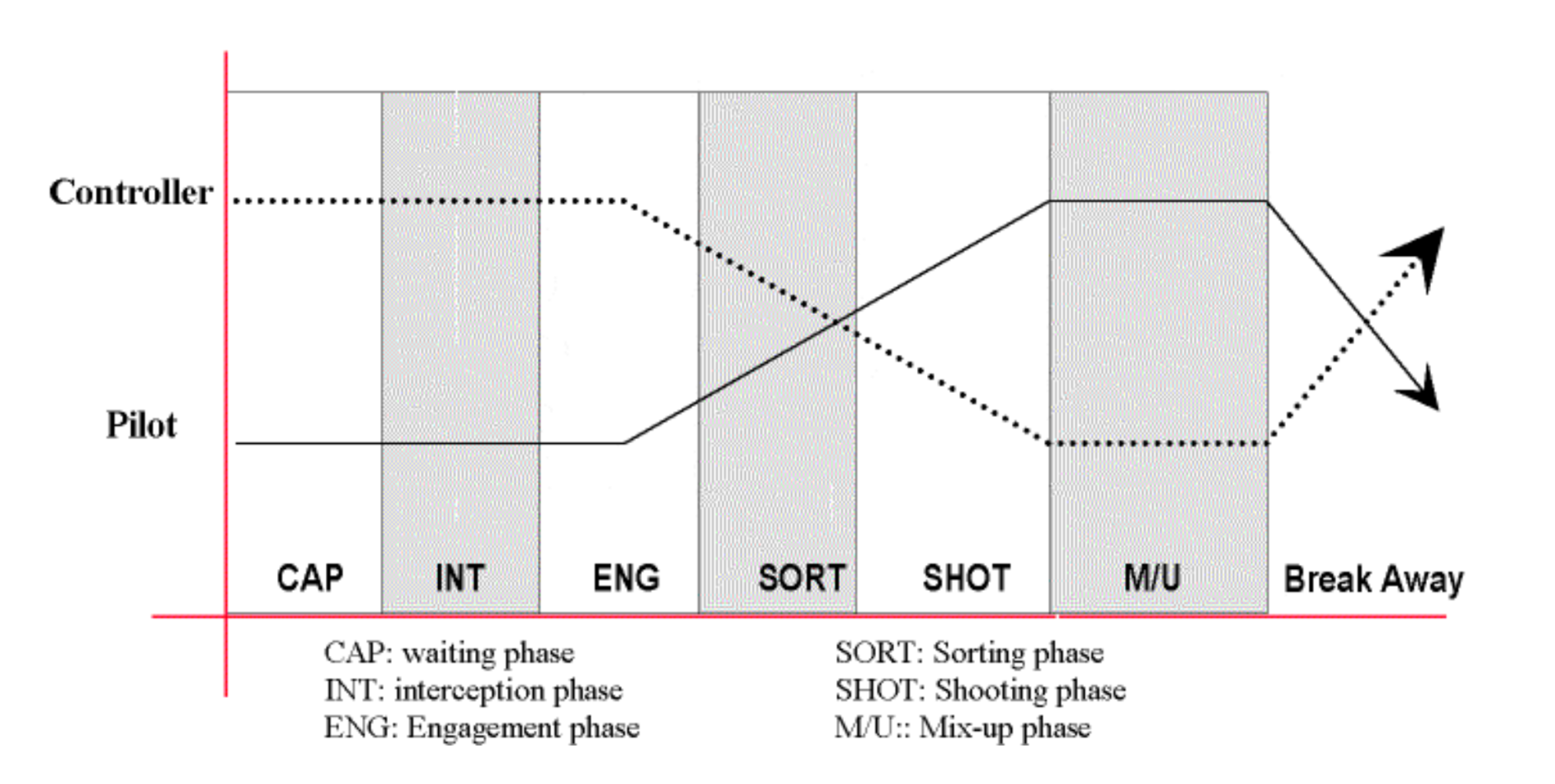
3-Picture building
Diese Seite befindet sich derzeit im Aufbau. Einige der angebotenen Inhalte können unvollständig sein oder Fehler enthalten.
Introduction
In order to pass correct target and friendly aircraft positions to the Fighter pilots, it is necessary to use standard and concise format for the information flow. But since the Tactical Situation evolve because due to aircraft motion, the procedure must be updated.
This module will help you train yourself in building some basic and more complex pictures through paper exercises. After completion of this module, you will be able to:
- State the information already available in the pilot’s cockpit.
- Explain the Picture building concept.
- Explain how to group the picture.
Fighter Aircraft Displays
Modern aircraft now have a lot of information available from their own computers and displays: current precise position within an area, high performance Doppler radar, kill parameter calculations, Data links...Up to 5 display screens can be fitted:
- Head Up Display (HUD) is a translucent glass on which computer shows information, while the pilot is continuing to look at outside.
- High Level Display (HLD) is a color screen on which the pilot can display the information he needs for a given situation. Usually, in an AD Fighter, the AI Radar data is shown here.
- Lateral Displays (LLD for the Left, RLD for the Right) are also colour screens and can show information on request, such as Engine parameters, Weapons states, Electronic Warfare inputs etc.
- Head Down Display (HDD) is a similar kind of screen, used to show the Tactical Situation or Radar data. Of course, it can also show any other information.
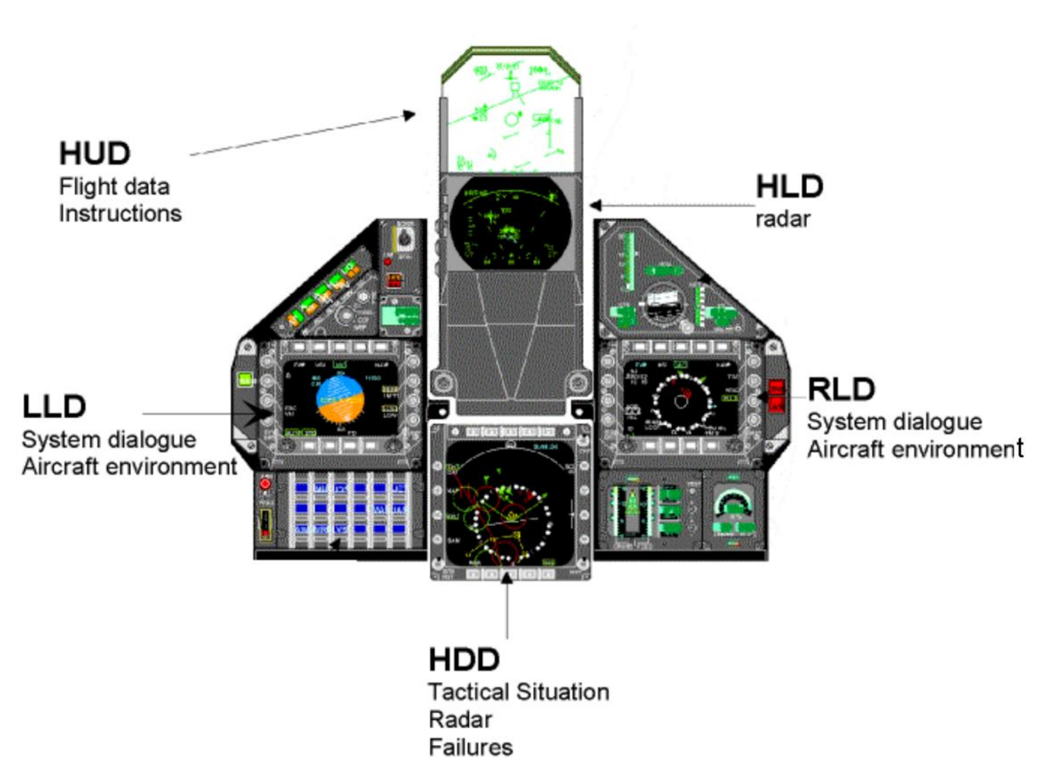
Example of aircraft display setup (M2000-5)
Tactical Situation: The Tactical Situation is the overview of the environment and the Air activity in a specified area. A pilot can display the following information:
- Parts of the ACO (FAOR, Bull’s eye, Zones, Reference points...)
- Parts of the Order of Battle (Friendly and Hostile SAM rings, airfields...)
- Any information loaded in the computer before take-off
- Friendly and Hostile air activity (radar detection)
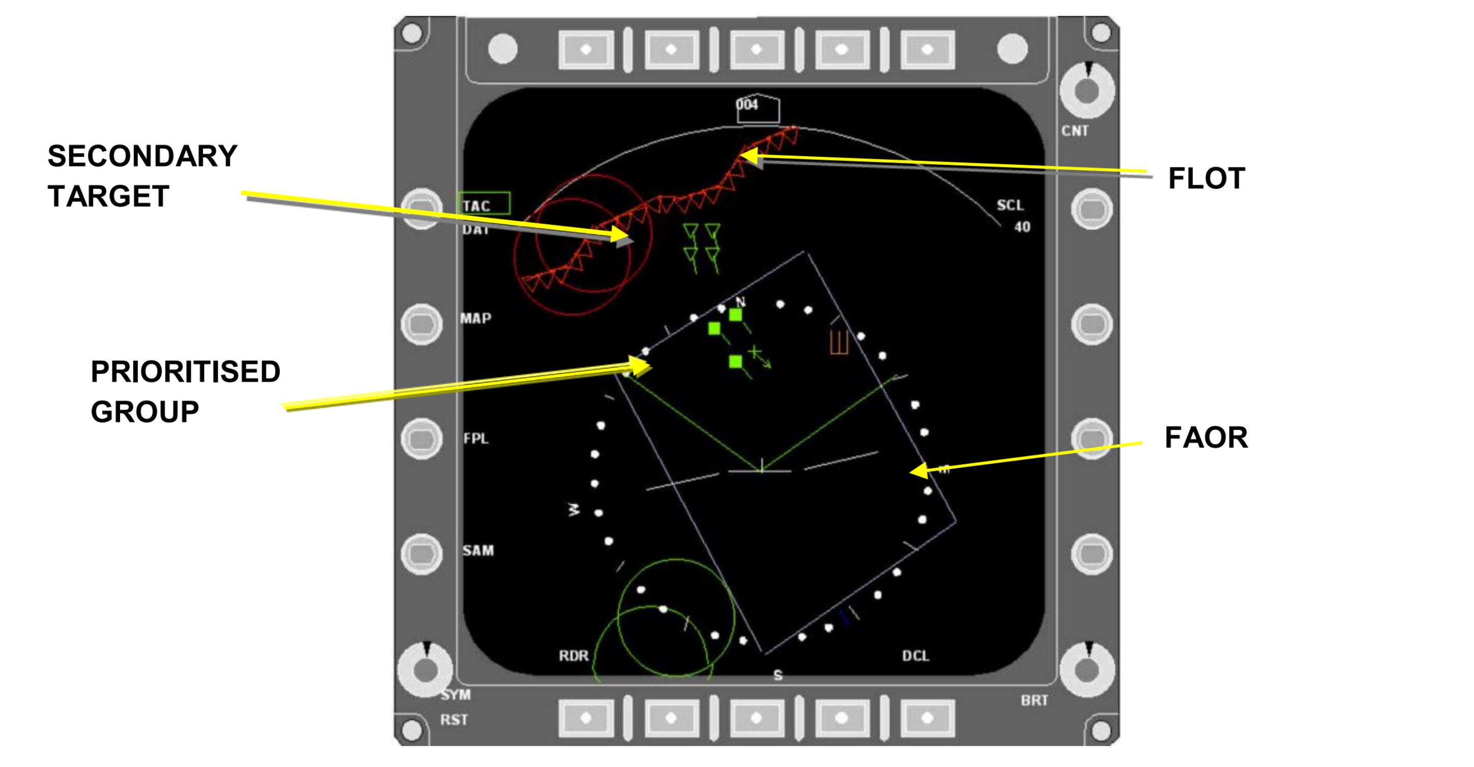
Example of Tactical Situation display (M2000-5)
A pilot has a good Situational Awareness (SA) if he is aware of the whole of both friendly and hostile activity in his vicinity. He will prioritize the information he receives from the aircraft systems.
Picture
The “Picture” is the translation in words of a radar image from one participant to another participant in an operation. It can be a “Surface Picture” or an “Air Picture”. It includes the classification of positively identified responses and can be provided by a Fighter Controller or any aircraft with radar capability.
The role of the controller is to extend the field of view of the pilot and to warn him if a new threat occurs.
Picture Building concepts
The major difference between the controllers display and the pilot’s one is that the controller sees a “RAP - Recognized Air Picture”. Pilots do NOT have any ID available in the cockpit. This ID is the criteria that will allow or not a BVR SHOT.
The main task of the controller is to provide the pilot with the IDENTIFICATION of all detected aircraft
Even for a pilot, the Friendly situation should be relatively easy to identify (from knowledge of the ATO, and/or IFF analysis through the interrogator), but the Unknown and Hostile situation may be more difficult. So the controller should also try to pass additional and complementary data to improve the overall SA.
Communications have to be as clear as possible to give the pilots the right information in the clearest terms, so extensive use is made of labels and codewords to minimize RT transmission time.
Trend Analysis
The initial description of the Picture should have included the Ident, perhaps Strength and BRAA.
But to provide more accurate information, the controller must evaluate the trends of each detected aircraft/group.
This is nothing but marking the scope (in any way) with ground positions to figure out if the responses are marshalling prior to a push, orbiting or counter-rotating (indicating on CAP), or maneuvering in any special way. By using this technique it may be possible to assess their intentions.
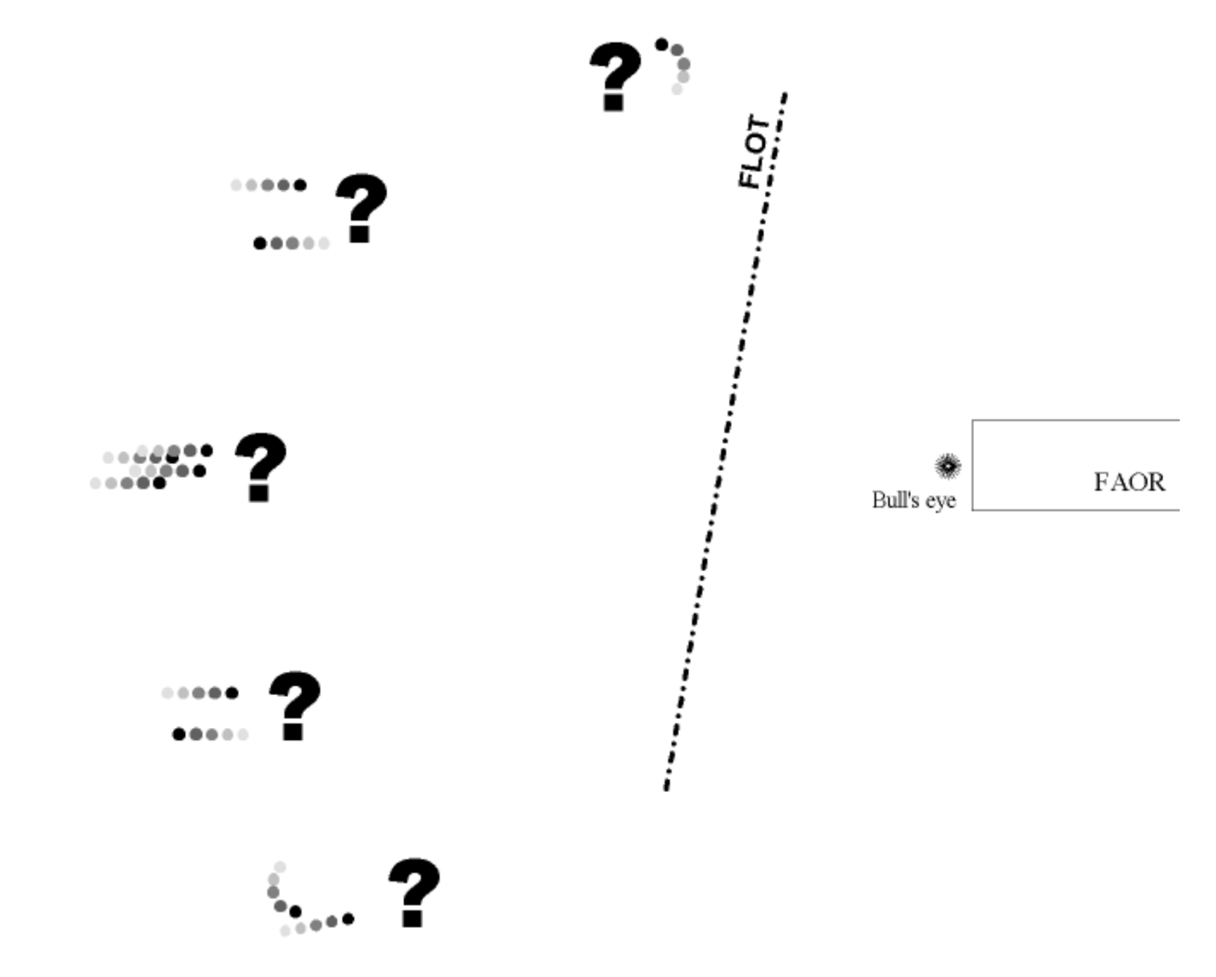
Trend Analysis.
Grouping the Picture
Following the Trend Analysis, the controller is able to group contacts together.
Group labels are usually used for aircraft flying less than 3nm from each other. Aircraft flying beyond this range must be reported as another group or as individuals.
A big group may be composed of several groups. If several groups are together, they may be described as Packages.
If the enemy activity is heavy, state the total number of detected groups, but only report the THREE closest to your fighters.
Avoid confusion!
Never say “first group 360/10, second group 040/15”. Just call them group.
If pilot or controller has amplifying information on one group, then group’s location (azimuth and range from Bull’s eye) must be used. It avoids ambiguous calls or misunderstandings.
As an example: Group, 270/65, 23000, Hot, Bandit.
Bounding Range
To regulate aircraft grouping and to simplify the picture transmission, a limitation in distance is defined as Bounding Range.
Within this range, groups position can be broadcast in relative position from each other.
Beyond this range, groups must be reported separately. Usually set at 30nm, this range may be modified by the Flight Leader.
Relative positions
There are 3 categories of labels to position 2 groups between each other: azimuth, range and altitude.
If the groups have azimuth relative positions from the pilot point of view, then use
“AZIMUTH” term + range, with the 4 cardinal directions (e.g. NORTH(ERN) GROUP, EAST(ERN) GROUP...).
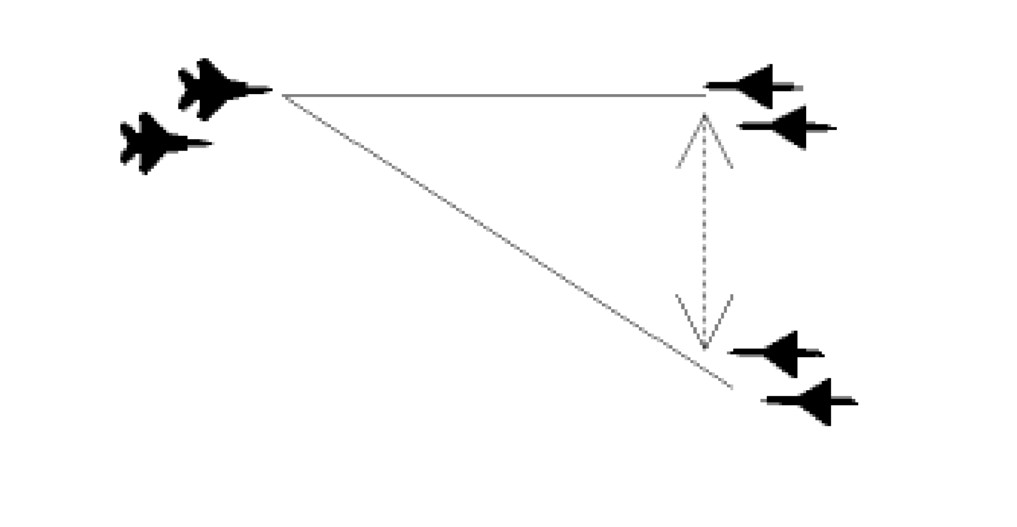
If the groups have a range relative position from the pilot point of view, then use
“RANGE” term + range and use LEADER GROUP and TRAILER GROUP names.
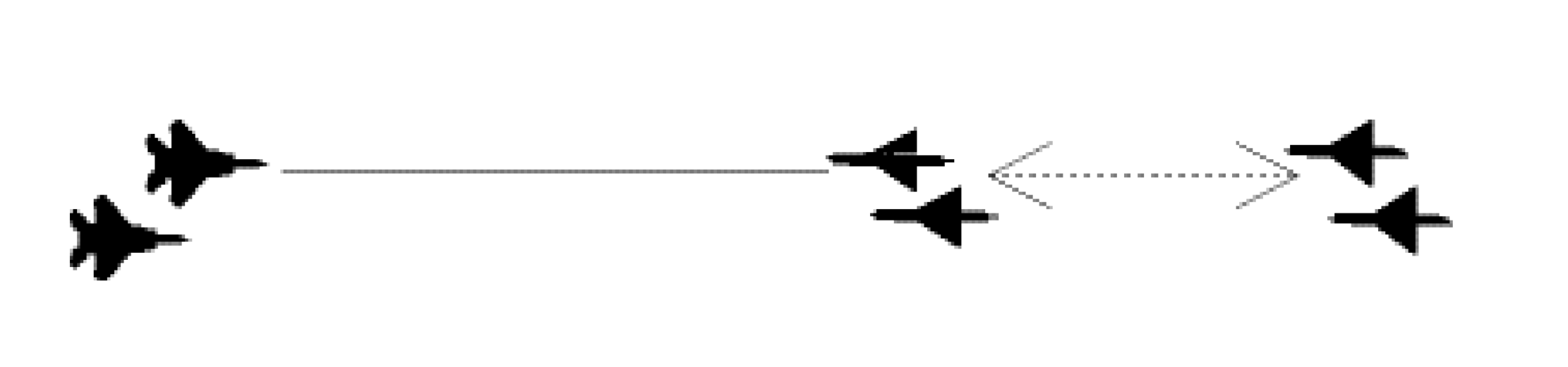
If the groups have an altitude separation, then use “STACK” and label the highest group as HIGH GROUP and the lowest one as LOW GROUP.
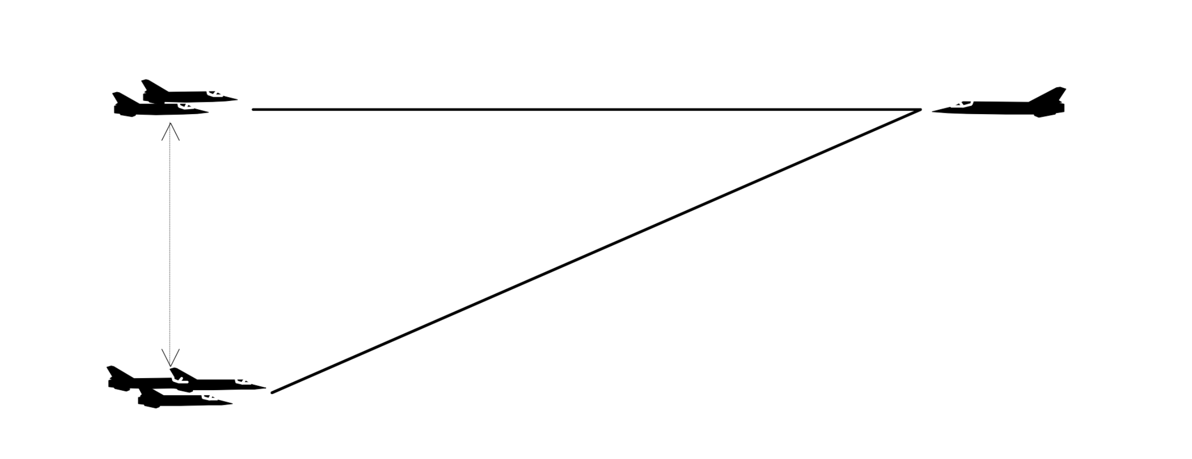
Example of a grouped picture:
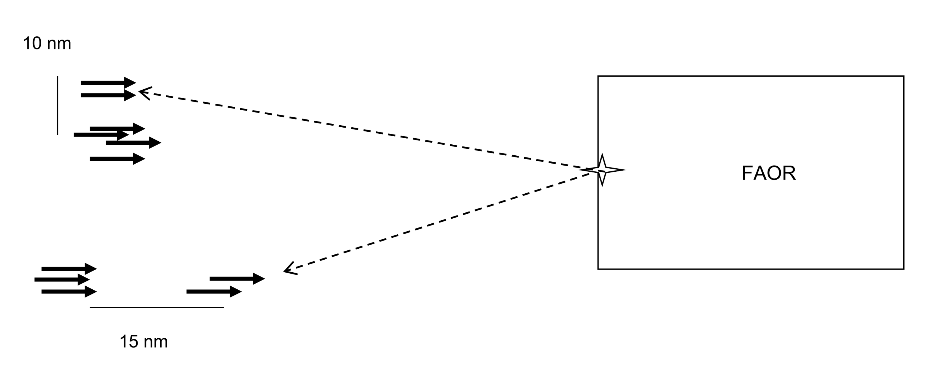
| NATO 31, 4 GROUPS WEST BULLSEYE 50, LOW, HOT, HOSTILE |
| SOUTHERN PACKAGE, 2 GROUPS RANGE SPLIT 15, LEADER 255/50 |
| NORTHERN PACKAGE, 2 GROUPS AZIMUTH SPLIT 10, NORTHERN 295/80 |
Labeling the Picture
Labeling Contacts: This allows the fighter mission commander to sort the targets. Remember that the priority for the fighter is the location of Hostile threats, especially enemy CAPS, which must be sanitized (cleaned or killed).
If aircraft can be positively identified as CAP, even if they are separated but working together, then label the group as “CAP” and continue using this label for each communication concerning this group.
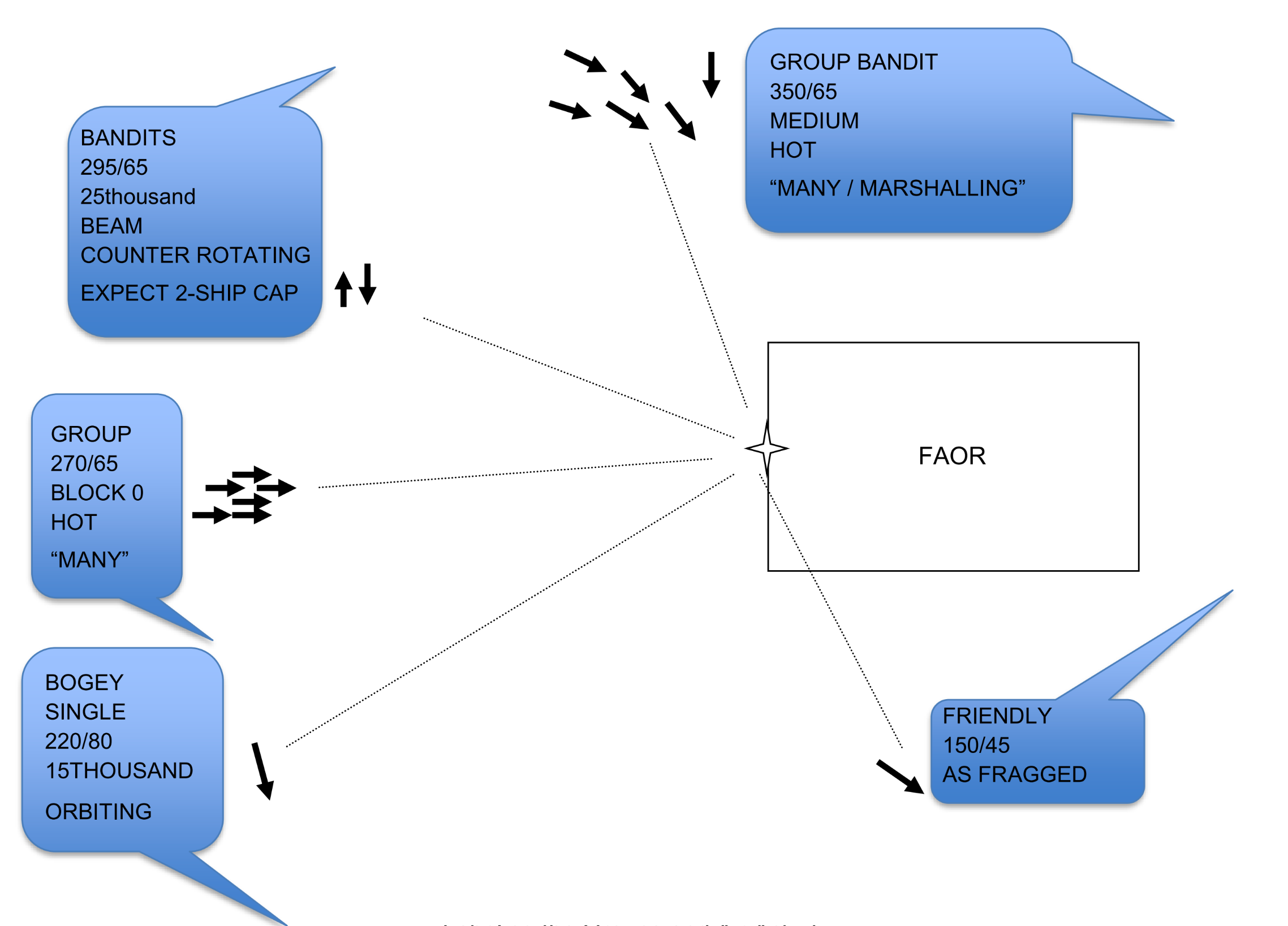
Labeling the Groups and Air Activity.
The RT Sequence
The first picture description follows the format BRAA. Successive updates must include the POSITION with label (if adressed) as a reference.
Then, depending upon the situation, the controller keeps pilots informed of what enemy is doing (descending, dragging or beaming etc) and then height and aspect.
The main point is to get the picture across to the pilot concisely and accurately!
Do not try to put all information into one long RT transmission, but never interrupt the BRAA sequence.
Updating the picture, monitoring the engagement
Listen to RT communications
The secret for a good Picture update is the capability of the controller to listen to all the RT communications from each participant, to understand what has been said and therefore, know exactly what the Flight Leader is doing, going to do and what he is aware of.
Say what you see! Like a camera, just report what you see.
- If you are able to confirm what the pilot is seeing, just call “Same picture” or “Same”.
- If you are unable to confirm because you have lost the picture, or you have some detection problems, call “Unable”.
- If something new happens, report it starting with NEW
e.g NEW group, 255-32, BOGEY etc... - If some changes occur about an already broadcast aircraft, report it using NOW
e.g Group 255-32, NOW BANDIT...
No important Situation change
Let the Flight Leader lead the radio communications flow. Because of the tactical situation, the strength of the raid, the changing tactics, you may have to assist the leader when he is engaging a group.
You should be able to track another group dragging or beaming away. Watch them and warn when they turn back hot. If the group maneuvers, report what you see: first the maneuver, then the heading.
Big Situation change
Because the enemy tactics are changing, their flight formations and paths may change by cross turns, U turns, Routing changes etc... So the picture must quickly be updated. Use the terms New Formation, New Group or Pop-Up.
Pop –Ups
If new contact(s) appear(s) between 20 and 50NM from your fighters, use the term POP-UP and broadcast using Bull’s eye reference (if no specific aircraft is threatened) or Tactical reference if one specific aircraft is threatened.
Before passing an IDENT, be sure that the Pop Up is not a Friendly, you may do this by listening to the RT (as a Friendly, he should call).
i.e. “NATO32, Nahyan, Pop-up Tactical 125-25, Hot, Hostile”
The use of the word ‘Tactical’ indicates to the pilot that the reference is from the fighter, not from the Bull’s eye.
Threat calls
If a contact(s) approach(es) one of your fighters (less than 20NM), without being detected by the pilot, or if a closer than 20NM pop-up contact appears, call for a THREAT CALL.
Format to apply then if as followed:
i.e. “NATO 31, Threat call BRAA (or Tactical) 125-12, head, hostile".
Before passing an IDENT, be sure that the Pop Up is not a Friendly, you may do this by listening to the RT (as a Friendly, he should call) and/or reading IFF code (see ATO for possible friendly movement scheduled in the area).
Faded responses (targets dark)
If contacts fade, and remain faded for at least 2 sweeps, call “Northern group, 255/54, NOW Faded”. Then use “Estimate Bull’s eye .../...” to anchor the responses you have lost.
After another few sweeps, if the contact is still faded, the information will be too old to be reliable. Then call “Faded group, last known Bull’s eye .../...”.
Note. By calling a group as “Faded”, you advise the leader that you can no longer accept targeting responsibility.
New picture
The Tactical situation may change at any moment because:
- Hostile groups are maneuvering
- Groups are splitting
- New group(s) appear(s)
Then allocated labels to each group do not reflect the situation any more. For these reasons a pilot may request a New Picture or the controller could initiate the new picture procedure. “New Picture” is the mandatory term prior to changing labels.
A “New Picture” call should only be made beyond the “NO New Picture Range” defined inside the briefing and occur when communications flow allows. If not, then initial labels should be maintained.
4-CAP Techniques
Diese Seite befindet sich derzeit im Aufbau. Einige der angebotenen Inhalte können unvollständig sein oder Fehler enthalten.
Introduction
This module explains the theory and practice of Combat Air Patrols. It describes the different procedures used within an FAOR environment as well. On completion, you will be able to:
- Describe the different CAP patterns.
- Explain the need of FAOR
- Describe the FAOR geographic shapes
- Describe the airspace organisation
- Explain CAP procedures
Combat Air Patrol (CAP)
Combat Air Patrols (CAPs) are airborne patrols positioned as the tactical situation demands. CAPs can be flown for several reasons, as a demonstration of air power, to provide some early warning (if the fighter has a radar) but, more importantly, to respond very quickly to any possible air attack.
The main disadvantage is that even keeping a single CAP position will require several aircraft, to allow for change-overs due to fuel shortages.
Position
The position of a CAP is obviously very important, and depends upon the direction of the threat, but the location of ‘vulnerable points’ (VPs), airbases, prominent geographical features, plus the availability or not of air to air refuelling (AAR), airborne early warning (AEW), and radar control from ships, must also be considered.
CAP Flight patterns
CAP along (towards) the Threat Axis
Aircraft equipped with long range radar (such as EUFI or M2000) can search for the threat on an outbound leg but then are “blind” on the inbound leg. This pattern is used when a reliable ground radar coverage is provided (GCI or AEW).
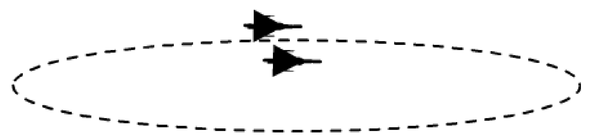
CAP
Counter-rotating CAP
When reliable ground radar coverage is not provided (GCI or AEW), CAP aircraft must continuously scan the airspace towards the threat origin area. So they fly separately and arrange their path to always keep an aircraft facing the threat (IN or HOT LEG) whilst the other in backing (OUT or COLD LEG).
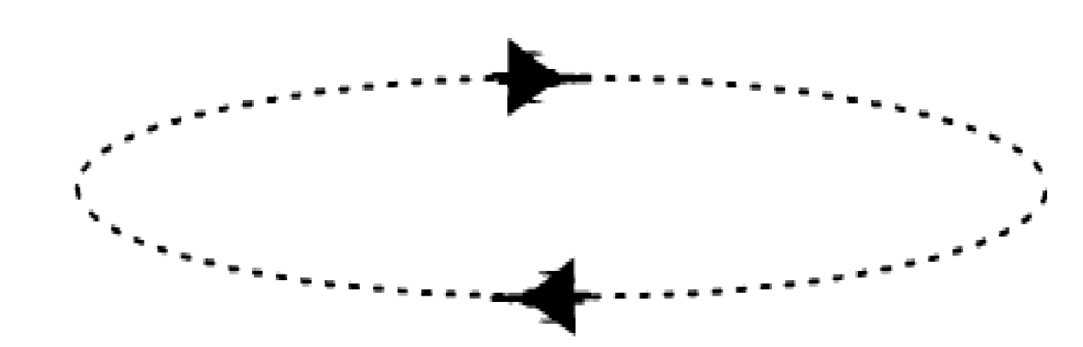
Counter-rotating CAP
Counter-opposing CAP
If many aircraft are tasked as CAP in a same area for the same mission (4-ship patrol or 2 different pairs) they may fly in separate CAP locations and manage their paths to always keep a pair scanning airspace towards the threat origin area. In this situation, one single CAP commander will be responsible of engagement.
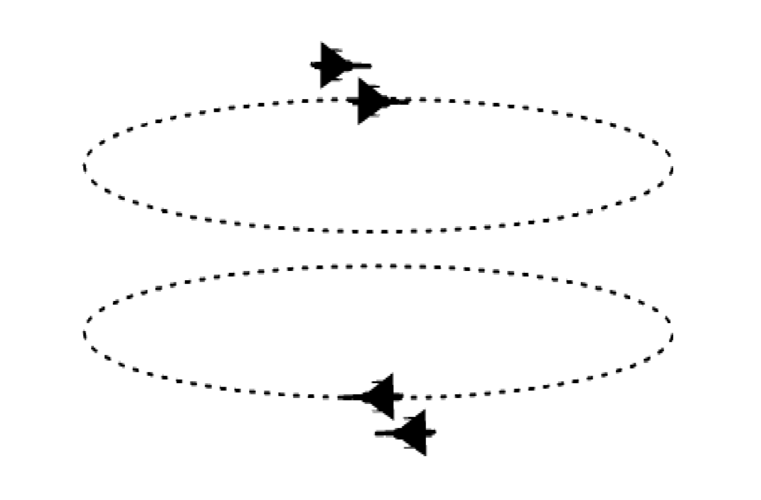
Counter-opposing CAP
Beam CAP
In certain occasions because of the tactical situation, or for non-radar equipped aircraft, CAP may be oriented perpendicular to the area of operations or ingress route of flight.
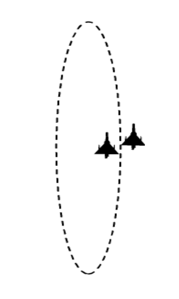
Organisation
CAP missions may be conducted through different ways, either outside or within specific allocated areas.
When CAP aircraft are only allocated a CAP point, it may become difficult to coordinate the engagement if many targets threaten the area. It is then necessary to define who must engage and which threats (ROEs).
The allocation of a defined area to a CAP fighter eases the engagement. Such an area is named Fighter Area Of Responsibility (FAOR).
Types of control:
CAP outside FAOR --> LOOSE or CLOSE, POSITIVE or ADVISORY
CAP within FAOR --> ONLY LOOSE ADVISORY
FAOR
The Fighter Area Of Responsibility (FAOR) is an airspace of defined dimensions where Air Defense Fighters have the primary responsibility for:
- Patrolling
- Intercepting
- Engaging
Any unidentified aircraft detected and flying inside an FAOR must be intercepted, identified, classified and engaged if necessary.
Advantages of FAOR
When airspace becomes complicated because of multiple missions taking place in it, it is necessary to organise it in accordance with the
requirements of each specific mission. When an area is designed to protect heavy air activity, FAOR is designed to make the engagement easier.
Procedures
CAP point, bull’s eye, frequencies, and sometimes IFF codes for mode 3, are assigned to each FAOR. So a CAP pilot will immediately and
automatically be aware of all the data associated with the area he is going to fly in.
Engagement
Through the picture provided by Fighter Controllers, pilots have a good situational awareness within their allocated area. They can immediately react when pop-up traffic appears, detected or not by the ground radar site.
Also, when the controller is completely busy, or radio contact is lost (frequencies jammed or failure), pilots know that they are responsible for air superiority within their allocated FAOR.
Planning
When many CAPs are planned for a long period, it is much easier to associate the CAP, the station time with the FAOR.
Location
FAOR is designed to position defensive fighter aircraft as far as possible from the vulnerable area, towards the threat origin. It can be located beyond the Missile Engagement Zones, or on the other side, depending on the priorities of engagement defined by the Force Commander.
FAOR can be isolated if the probability if threat is low. If the probability of threat is higher, then FAORs can be joined to border each other in order to act as “Barrier CAP”.
Shape
There is no specific requirement for the shape of an FAOR. It must allow aircraft to maneuver within it. The needs and the tactical situation define the best use of the airspace. Usually a rectangle is chosen because it offers 2 side longer than the others, allowing longer radar scanning by the fighters.
The limits of the FAOR may be either lines joining geographic points or lines of Latitude and Longitude.
Size requirements
The FAOR size should allow fighter aircraft to maneuver as freely as possible to perform their task. Also the weapon system and the missiles capabilities should be integrated when the FAOR is designed. The Long-range capability of MICA and AMRAAM requires sizes not to be shorter than 50-60nm long and 40nm wide.
Orientation
The shortest side should always face the threat.
Airspace Organisation
CAP Point
The CAP point, also called “Anchor point” is a geographic reference point defined by the ACO and associated with the FAOR. It is the racetrack origin. If the tactical situation requires, both pilots and controllers can move the CAP point location. If so, each one must ensure that the new position is known by all other users.
A CAP point may also be used independently of an FAOR. In this case, there is no lateral limits for pilots responsibilities and engagement should be coordinated between pilots and controllers.
Racetrack
The racetrack is a defined pattern to be used by pilots when patrolling. Its orientation depends upon the FAOR orientation itself.
It is composed of 2 legs:
- one leg towards the threat sector (Hot leg)
- and the other one when flying the opposite direction (Cold leg).
It can be flown “clockwise” or “Counter clockwise”; this must be defined by the CAP leader. Fighter aircraft can fly together or separately. If a GCI or AEW controller is available, with no restriction in the radar coverage, they will fly together. They can scan in the threat direction only on the hot leg, and their picture will rely on the controller when flying the cold leg. The role of the controller is then to keep the pilot’s situational awareness current.
If detection is poor or if no controller is available, or if the hostile picture requires, they will adopt the Counter Rotating or Counter Opposing CAP profiles. They will split in 2 single ships and fly separately in order to always keep 1 aircraft on the hot leg, while the other one is cold.
The leader must co-ordinate their paths. Same profile will apply when 2 pairs fly anchored at the same CAP point.
Bull’s Eye (BE)
The Bull’s Eye is a reference point, defined in the ACO, and used to transmit the picture. When it is associated with an FAOR, the BE is always located on the edge towards the threat. There is only one BE associated with an FAOR, but many others can be used outside it.
When using a different BE, both pilots and controllers must state the BE name used as a reference for this transmission.
Desired Engagement Zone (DEZ)
The Desired Engagement Zone is an area within the FAOR where engagement is expected. Located on the threat side of the FAOR, it is used to ensure that the pilots will neither engage too early nor too late.
All interception calculations are based on this location.
Kill Box
The Kill Box is the extension of the DEZ, located outside the FAOR. It is strictly forbidden for friendly aircraft to fly in a Kill Box. Therefore every contact gained in this area will be immediately engaged and destroyed.
Commit Line
The Commit Line is a line located far away from the Kill Box, towards the threat, and at the same distance from the FAOR Bull’s Eye as the fighter CAP position.
The commit decision must be taken before enemy aircraft cross it.
Stop Line
To give the Kill Box its complete credibility, as mentioned above, it must be mandatory that none of the friendly aircraft will fly in it. So a Stop Line is defined on the FAOR boundary, between the DEZ and the Kill Box.
Drop Line
Located within the DEZ at about 10/15NM (defined by the CAP leader) from the Stop line, this line is the limit where fighters stop monitoring a specified target and resume search responsibilities. Fighters then reduce the risk of crossing the stop line and entering the Kill box.
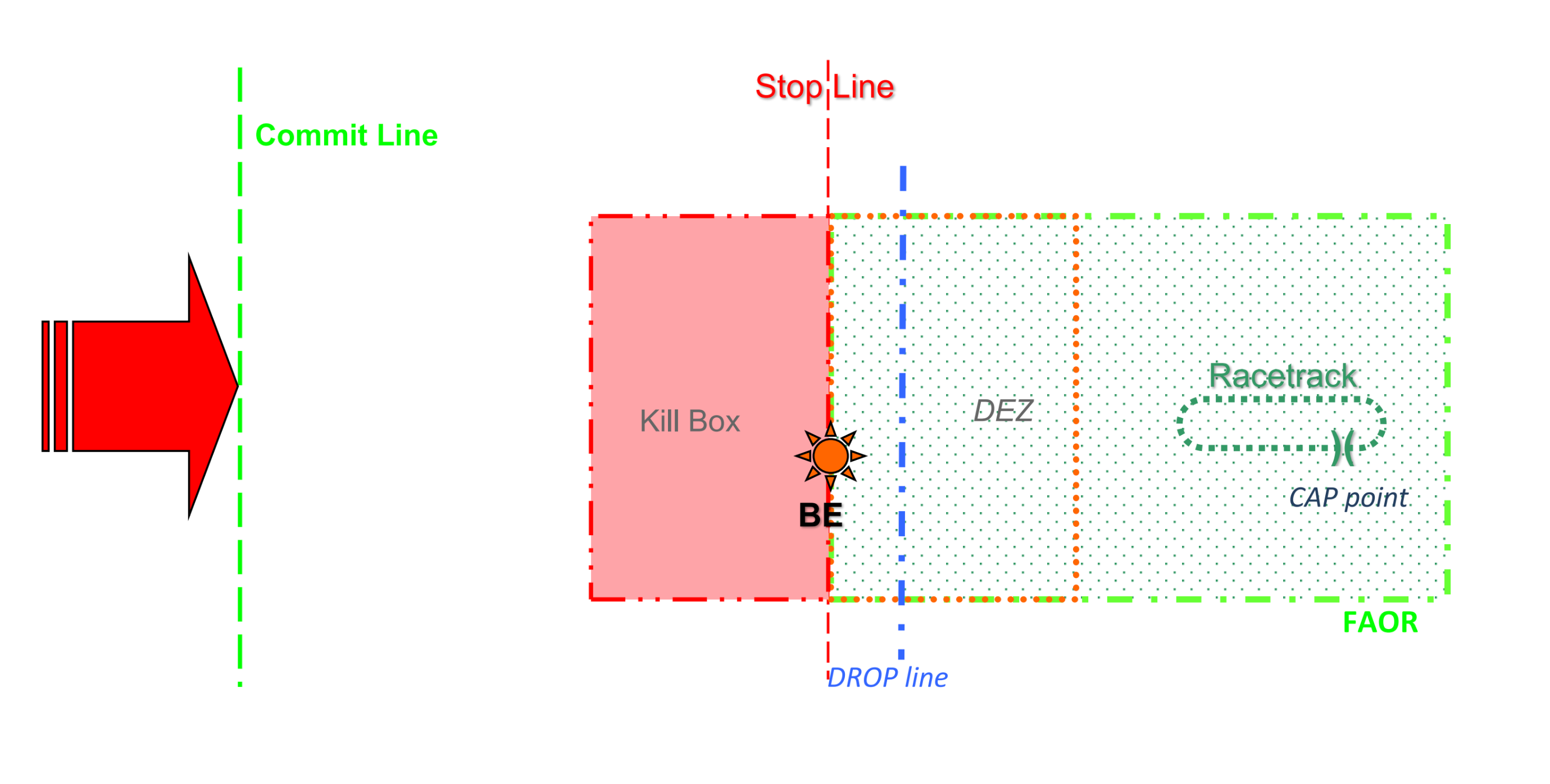
Techniques
Alfa Check
When taking over a CAP mission, the controller must check the Bull’s Eye position with the pilot. This will ensure that both are using the same reference point for the picture broadcast. This step is called “Alfa Check” and must be performed as soon as possible before transmitting any picture. Requested by either the pilot or the controller, the message contains the bearing and range to the Bull’s Eye from the fighter’s current position.
Radar work
To gain maximum efficiency, both aircraft of the same pair share the airspace scanning. They adjust radar parameters to give maximum horizontal coverage, the left hand side pilot optimizing the left side of flight path, and the right hand one, the right side.
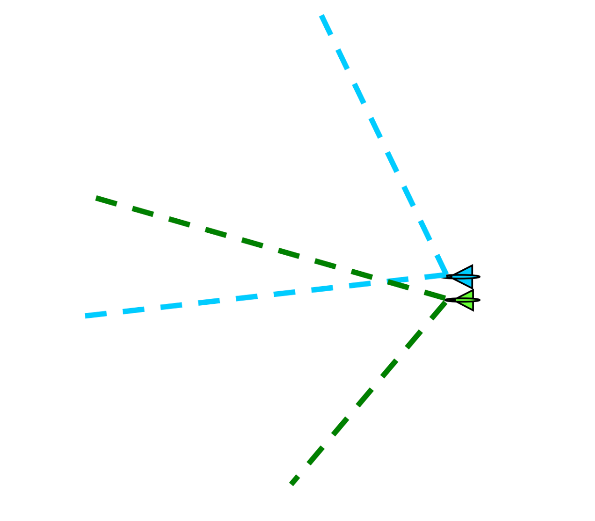
They also adjust radar parameters to give maximum vertical coverage, the left hand side pilot optimizing the lookdown from altitude path, and the right hand one, the lookup.
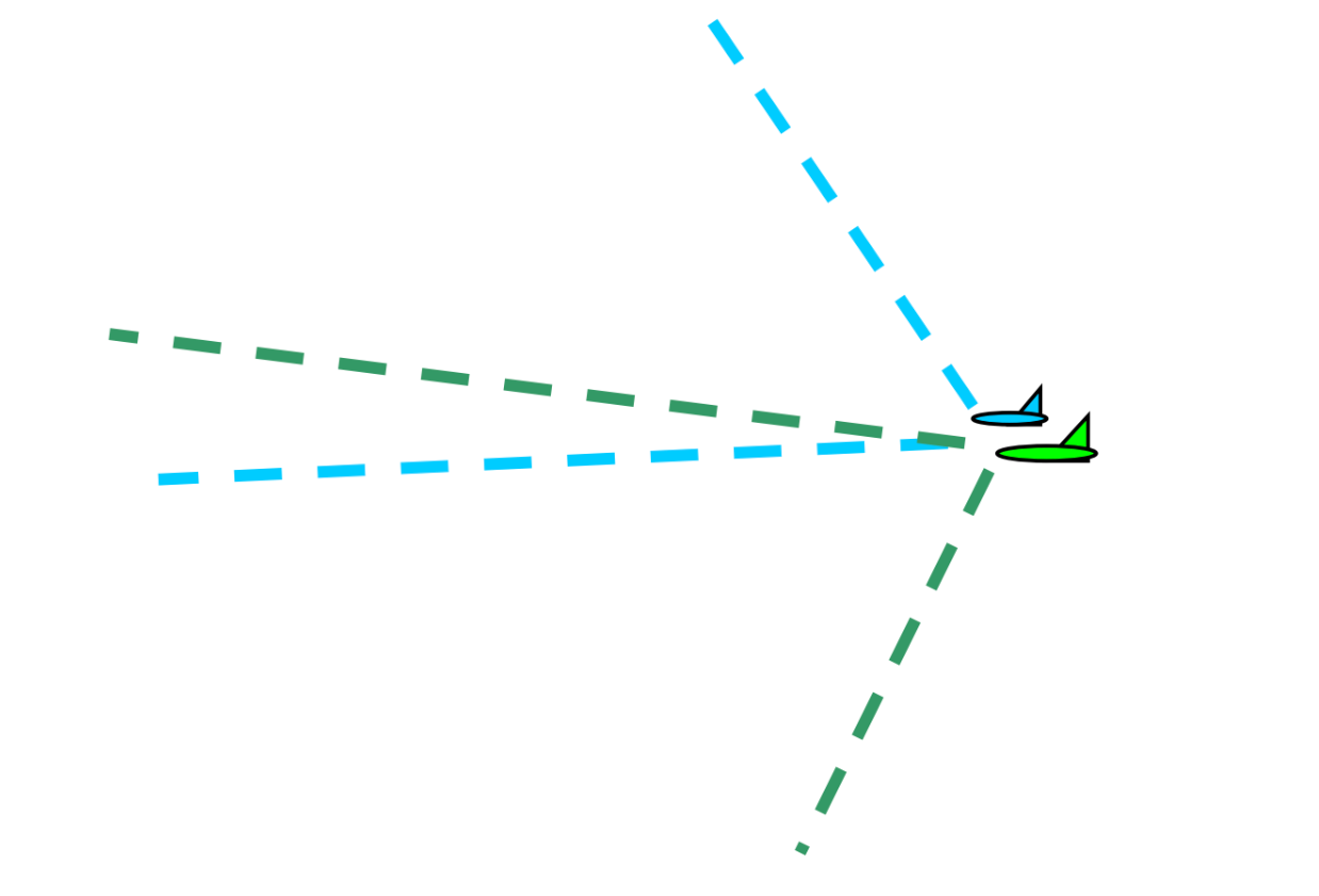
Chronology
Pilots expect an initial picture transmission as soon as they are in contact with the controller and after authentication and “Alfa check” are completed.
When a threat occurs, then:
- The controller broadcasts the picture Fighters prepare to engage, analyse the raid composition and decide who will commit to which bandit. This is “sorting”
- When Bandits cross the “Commit Line”, sorting must be completed and pilots calculate the point of interception, while still being on the racetrack. “There is no need to rush into the engagement...”
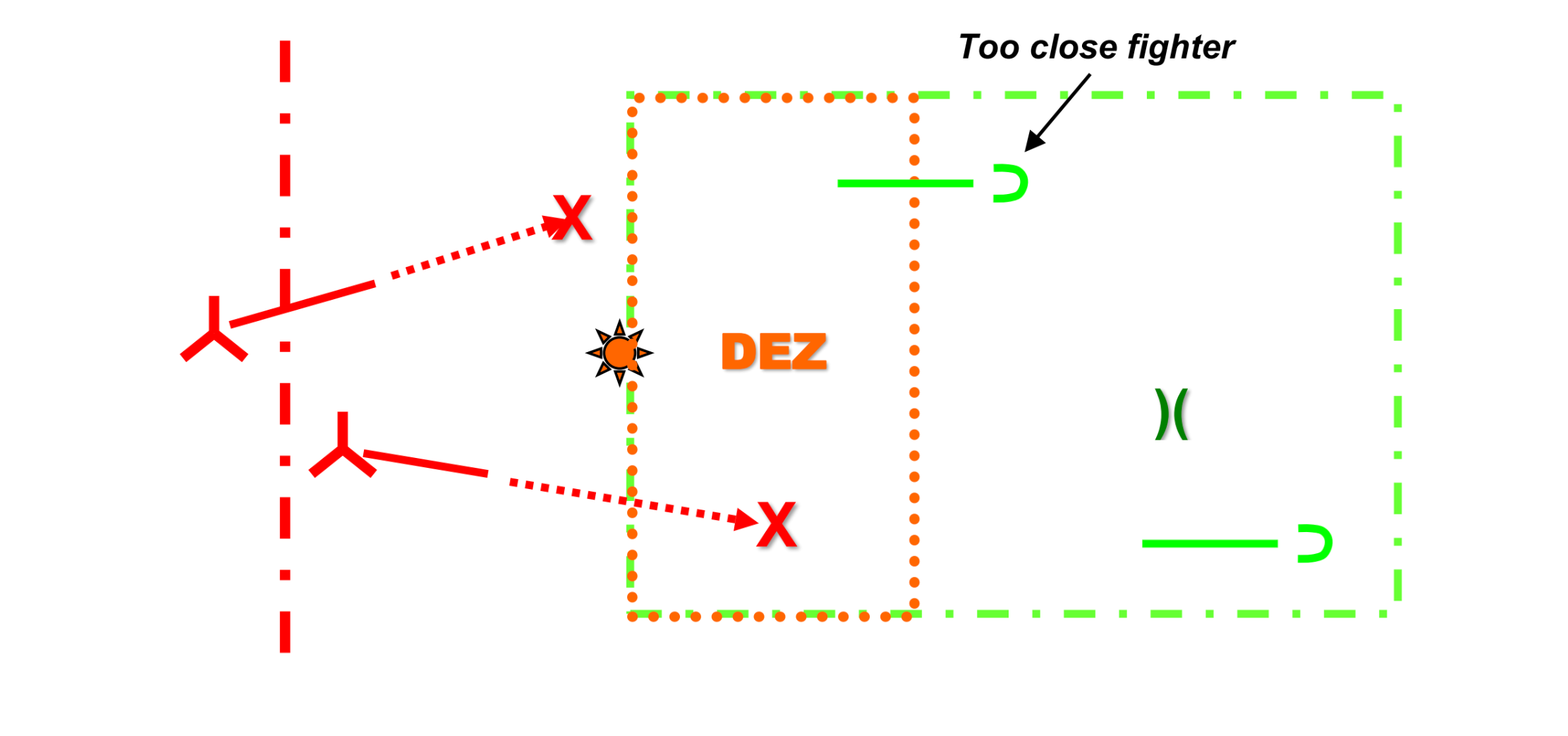
- When the Interception point reaches the DEZ, only then should the pilots engage.
- To avoid fratricide shots, it is essential that the fighters do not cross the “stop line”.
- Then if pilots are too close to the DEZ, they will fly a U-Turn (Pump maneuver) to reengage as soon as the range permits.
- While Pumping, pilots expect close monitoring of the air situation behind them.
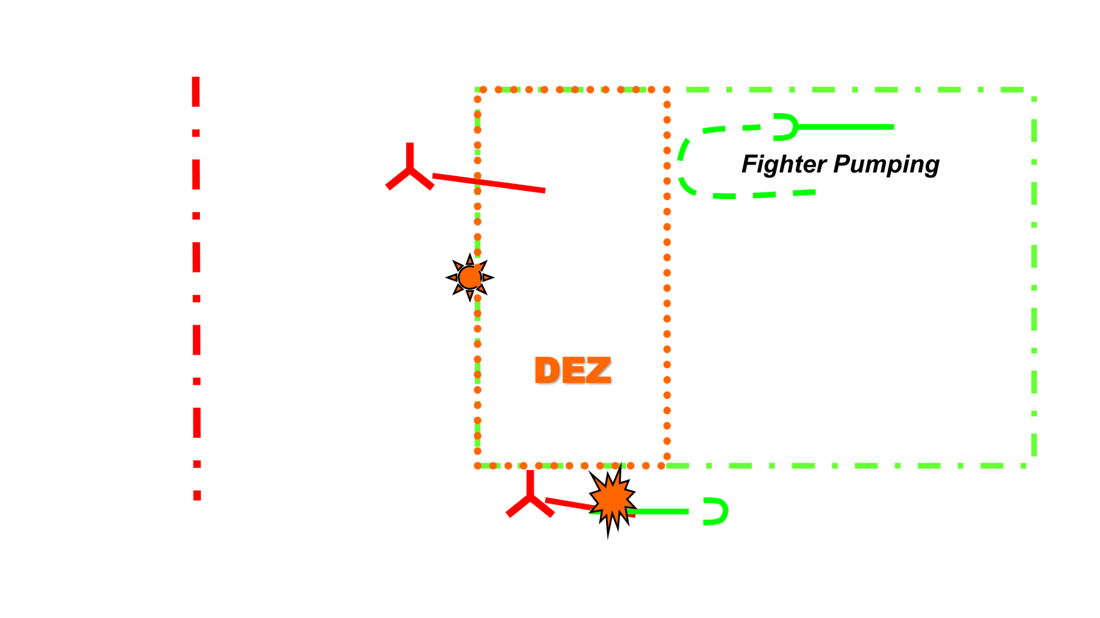
- When the engagement is completed and the enemy killed, the controller should collect different information:
- Engagement results (number of kills and weapons used)
- Remaining armament
- Remaining fuel or Playtime (time on station till Bingo)
Multiple FAOR
CAP Mission Commander (CAP MC)
If two or more FAOR are adjacent, a CAP Mission Commander (CAP MC) will be designated by the “AOC Plans Cell” through the ATO. He will be in charge of coordinating the aircraft availability, the reliefs and all engagements. He will expect the controller to assist him in managing the FAORs.
Hardwall
The “Hardwall” procedure exists to prevent the crossing of adjacent FAORs and associated “Kill Boxes” to:
- Ensure the safety between the different players.
- Define and clarify the engagement between them.
There must be also a good coordination between the different controllers.
Engagement
To face a heavy enemy raid (i.e Gorilla), the CAP MC could decide to talk to all the CAP assets on a single frequency to ease sorting through direct contact. Then the controllers must push their assets onto the CAP MC frequency. Also when the incoming threat is identified as heavy, far away from the FAORs, the FA can request the CAP MC controller to ask the pilots to push to the CAPMC frequency.
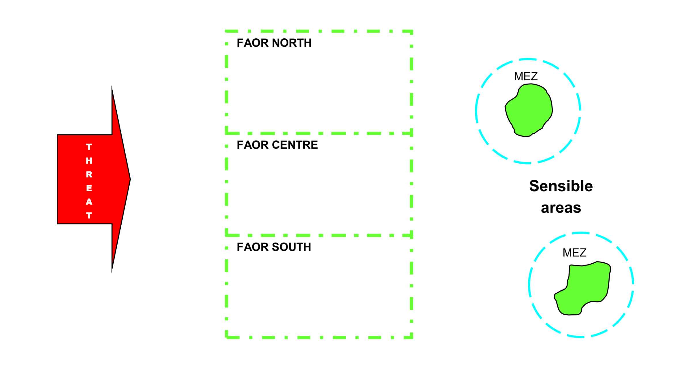
5-Flight Formations
Diese Seite befindet sich derzeit im Aufbau. Einige der angebotenen Inhalte können unvollständig sein oder Fehler enthalten.
Introduction
This module aims to give you an insight into some of the most commonly used combat tactics and flight formations.
Codewords are used extensively for pre-flight briefings and during the mission to exchange information and instructions, so you must be fully aware of them. After completion of this module, you will be able to:
- Understand the meaning of the flight formation code words.
- Use the correct code words to describe a package/group composition.
Flight Formations within a group
The following Flight Formations describe the relative positions of aircraft within a group. These terms are used by pilots describing what they detect with their radar. As the relative positions between aircraft within a group may be very tight, the controller should not use them but he must understand them when pilots describe a group composition.
CONTAINER
An attack of four distinct aircraft with two in front and two behind flying in a square formation.
 e.g. “4 a/c Container”
OFFSET CONTAINER
An attack of four distinct aircraft with two in front and two behind. The 2 trailers are moved laterally to an offset position left or right.
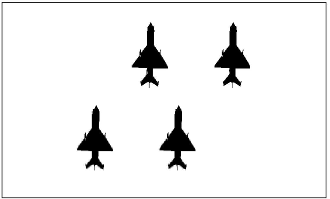
CARD
An attack of four distinct aircraft with one in front, two laterally displaced and one behind.
 e.g. “4 a/c left Offset Container”
COLUMN
Tactical formation of several aircraft flying in trail formation.
 e.g. “4 a/c Card”
ECHELON (Cardinal direction)
Contacts with wingman displaced approximately 45° behind leader's wing line.
 e.g. top ”2 a/c Echelon North”
bottom “4 a/c echelon east”
TRAIL
Tactical formation of two aircraft following one another.
e.g. “Two a/c in trail”
TRAILER
The last aircraft/group/formation in a formation following (in trail) an aircraft/group/formation at a range which cannot include him within the previous group.
 e.g. “One group VIC, one trailer 5”
LINE ABREAST
Two or more contacts side-by-side.
 e.g. “2 contacts, line abreast, 2”
STINGER
Formation of three or more aircraft with a single in TRAIL.
 e.g. “3 contacts, stinger”
WEDGE
Tactical formation of three or more aircraft with the single in front and the others aircraft laterally displaced on either side behind the leaders wing line.
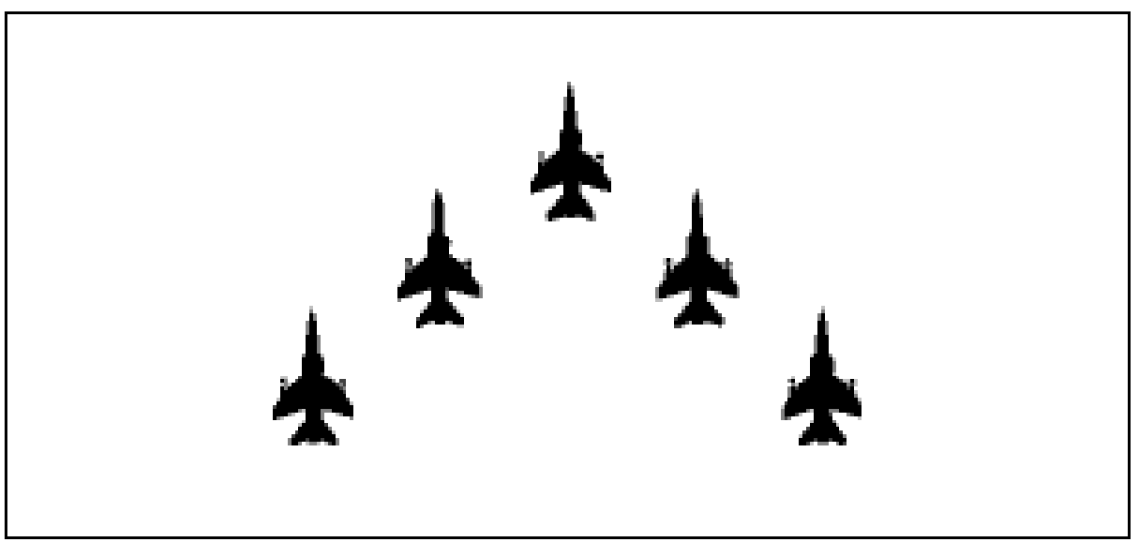
e.g. “Five contacts, Wedge”
Description of groups position
The following Flight Formations describe the relative positions of groups between each other. The controller should use them to describe the picture.
BOX
An attack of four distinct groups with two in front and two behind flying in a square formation.
e.g. “4 groups Box”
CHAMPAGNE
A picture label describing 3 distinct GROUPS with 2 in front and one behind from a God’s-eye-view. The two lateral groups will intend to decoy the opposite fighters when the central one will try to engage. This term is also used to describe this manoeuvre.
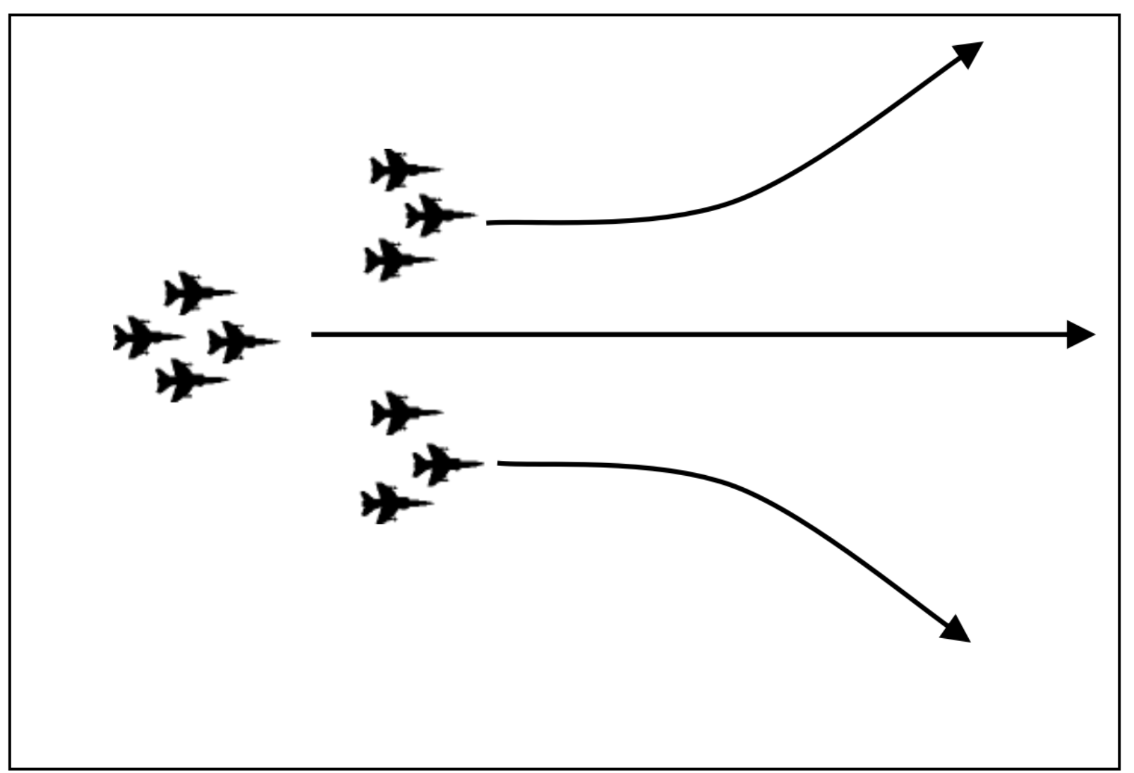
e.g. "3 groups, Champagne"
LADDER
Three or more groups/formations in trail.
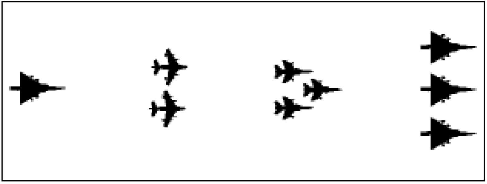
e.g. “3 groups, ladder, plus 1 trailer”
VIC
Three groups with the single closest in range and an element in trail. The closest will be named leader group, the trailers will be named e.g. eastern trailer group and western trailer group.
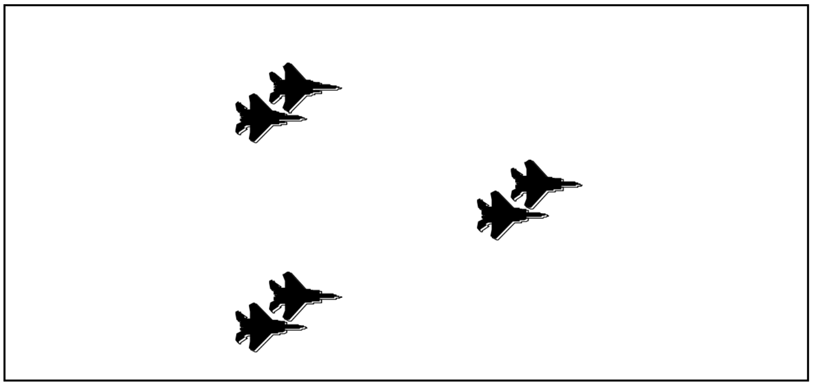
e.g. “3 groups, Vic”
WALL
Three or more groups/formations line abreast/side-side.
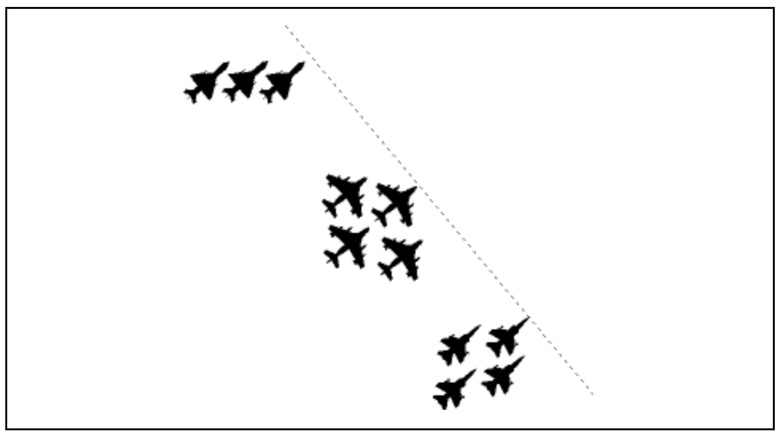
e.g. “Three groups, Wall”
RANGE SPLIT
Two or more groups primarily separated in distance along the same bearing.
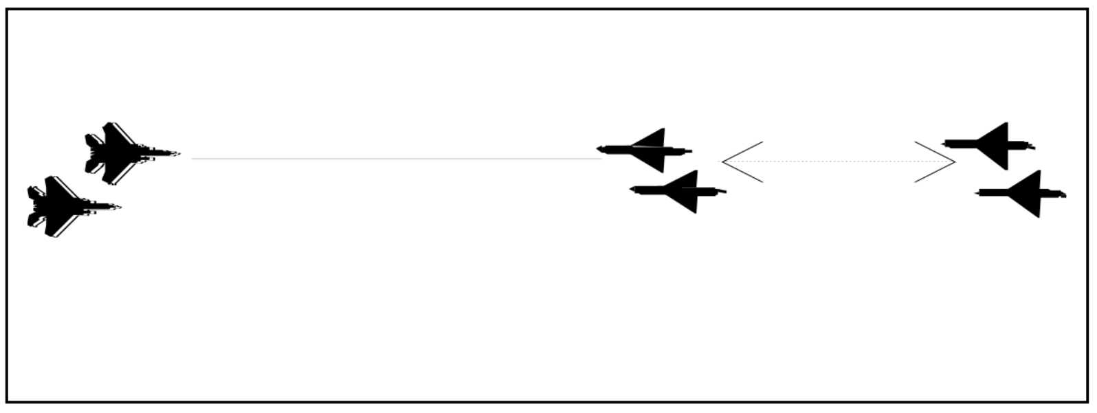
e.g. “Two groups, Range Split 15”
AZIMUTH SPLIT
Two or more groups primarily separated in bearing from a Fighter point of view. To use to describe Wall, Champagne… formations).
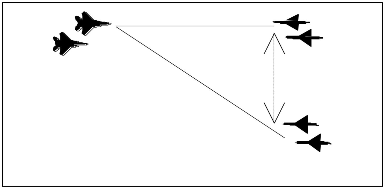
e.g. “Two groups, Azimuth Split 15”
STACK
Two or more groups, close to each other’s, but separated in altitude. Use High and Low to label the groups.

e.g. “Two groups, stack, low group 5000, high group 26000”
Remember that the terms RANGE and AZIMUTH refer to the pilot point of view, not the relative position of the groups between each other.
Example : The following example shows the different term to be used according to the position of the fighters you talk to.
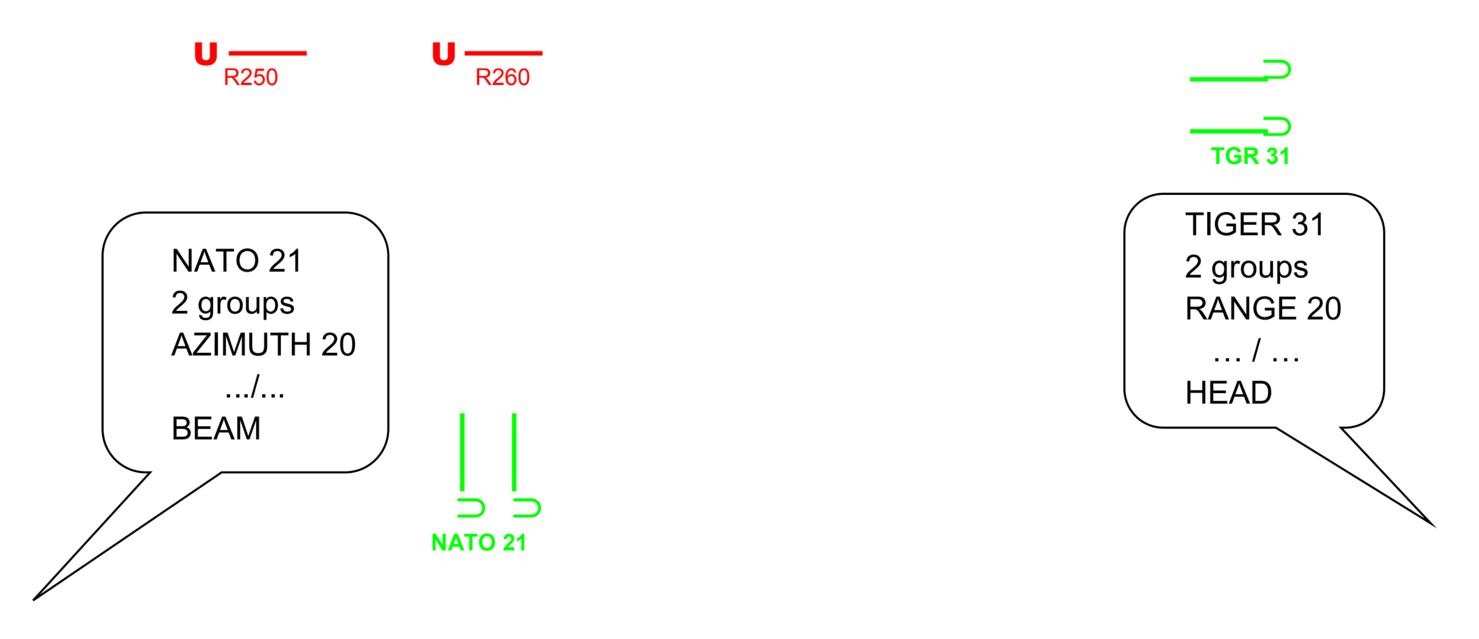
6-Combat Maneuvers
Diese Seite befindet sich derzeit im Aufbau. Einige der angebotenen Inhalte können unvollständig sein oder Fehler enthalten.
Introduction
This module aims to give you an insight into some of the most commonly used combat maneuvers and attempts to show when and how such maneuvers would be used.
Pilots will use specific terms in the pre-flight briefings, to describe the tactics they intend to use. So you should be aware of these terms. After completion of this module, you will be able to:
- Understand the planned tactics during the pre-briefing with the pilots.
- Understand what is going on during the engagement.
- Pass on short messages to the pilot, explain the enemy maneuvers.
Long range(Prior to engagement) maneuvers
Prior to the close engagement, fighters and bandits’ routes will move according to the tactical situation.
It is just as important to understand what the fighters’ tactics are as it is to explain the changes occurring within the enemy packages. Use the following terms to advise the leader of the situation.
Weave
Two allied aircraft fly in a weaving pattern, crossing paths regularly. This tactic makes it difficult for the enemy to focus on a single target and increases the chances of the wingman getting a shot at the attacker.

Pincer
Descriptive call to define a tactic where two bandits (enemy) flights separate in an attempt to attack both flanks (sides) of your formation. Also a tactic designed to maneuver an enemy into a defensive position by simultaneous attack from both sides of bogey.
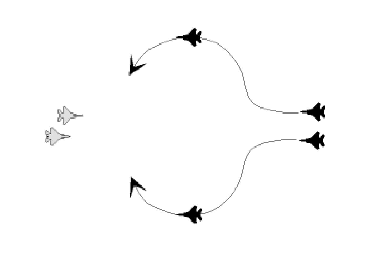
Cross turn
A 180° heading reversal by a flight where aircraft turn into each other.
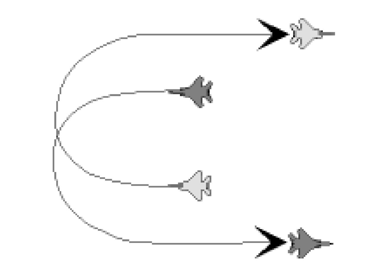
Cross turn weave
A 180° heading reversal by a flight where aircraft turn into each other and cross again.
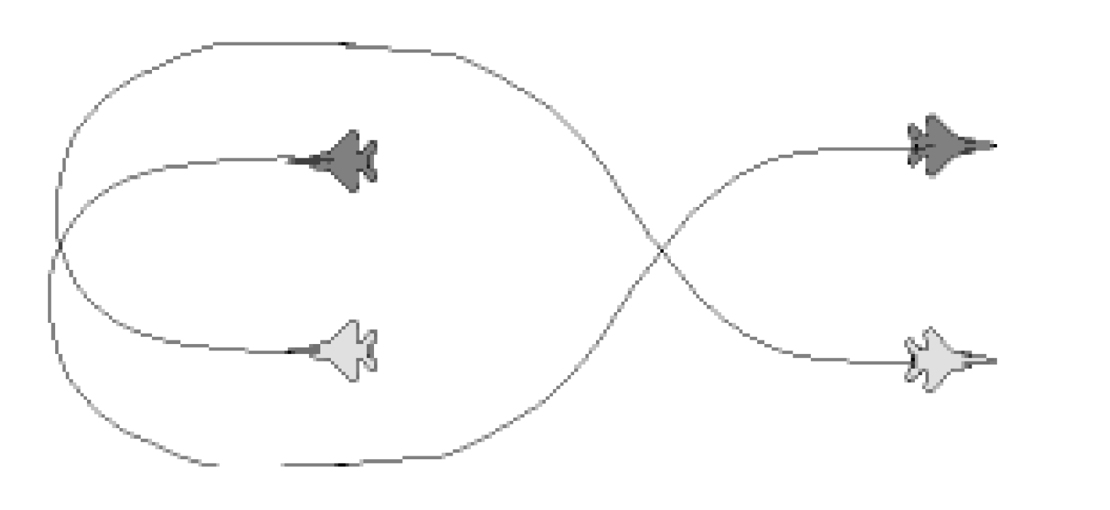
Attack Manoeuvers
Shackle
In this maneuver, the lead aircraft turns sharply to one side, while the wingman turns in the opposite direction. This creates a weaving pattern that can confuse the enemy and disrupt their targeting.
The goal is to force the enemy to constantly adjust their aim, giving the defenders an advantage.
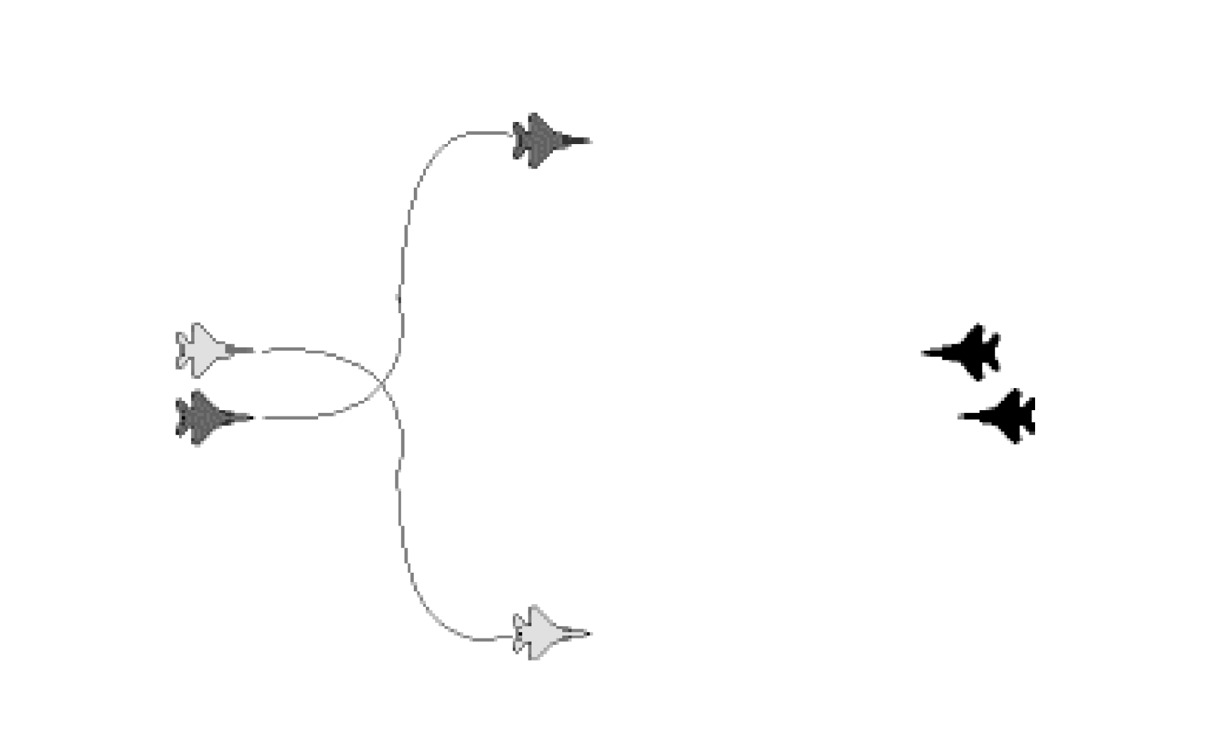
Bracket
Directive call to maneuver fighters on opposite sides laterally or vertically from the targets. This tactical air combat maneuver used by fighter aircraft aims to gain a positional advantage over an opponent.
In this maneuver, the attacking aircraft positions itself in such a way that it "brackets" or traps the enemy aircraft between two of its own aircraft. This positioning makes it difficult for the enemy to escape or counterattack effectively.
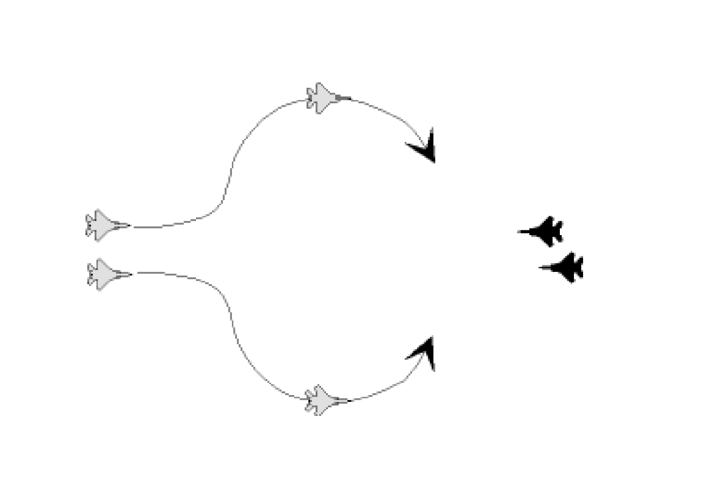
Single side offset
Directive/descriptive call where a fighter aircraft maneuvers to one side of an enemy aircraft, creating an offset position.
This maneuver is designed to place the attacking aircraft in a favorable position to launch an attack while minimizing the risk of being targeted by the enemy.
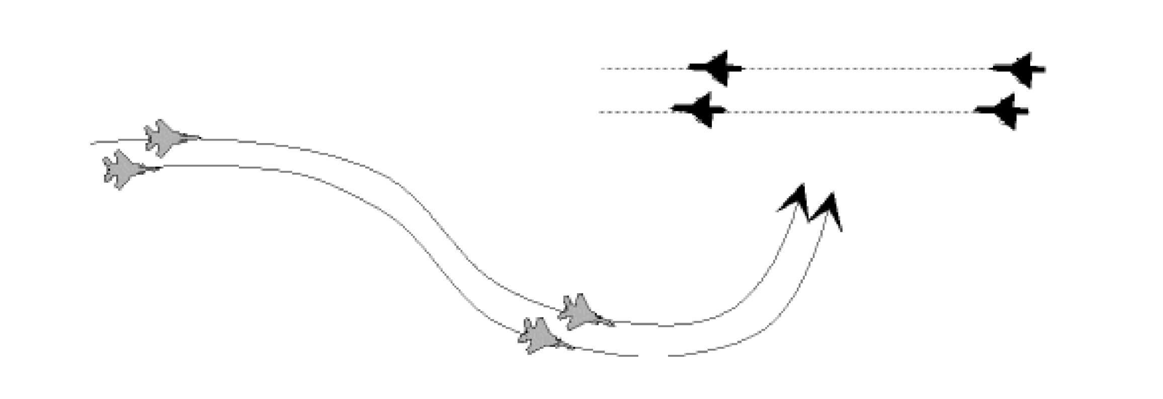
Flank
Description of the bogey/bandit maneuvering to position the fighter within 30 - 60° of the contact nose.
Aircraft maneuvering stabilized within 120 – 150° aspect.

Beam
Description of the bogey/bandit maneuvering to position the fighter within + 30° of the contact wingline.
Aircraft maneuvering stabilized within 70 – 110 ° aspect.
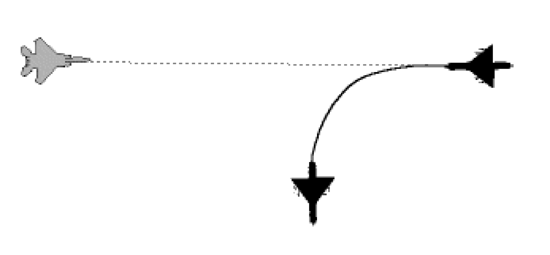
Drag
Description of the bogey/bandit maneuvering to position the fighter within + 60° of the Bogey/bandit’s tail.
Maneuver also designed to seduce enemy aircraft to follow one aircraft while another gets on his six to destroy him.
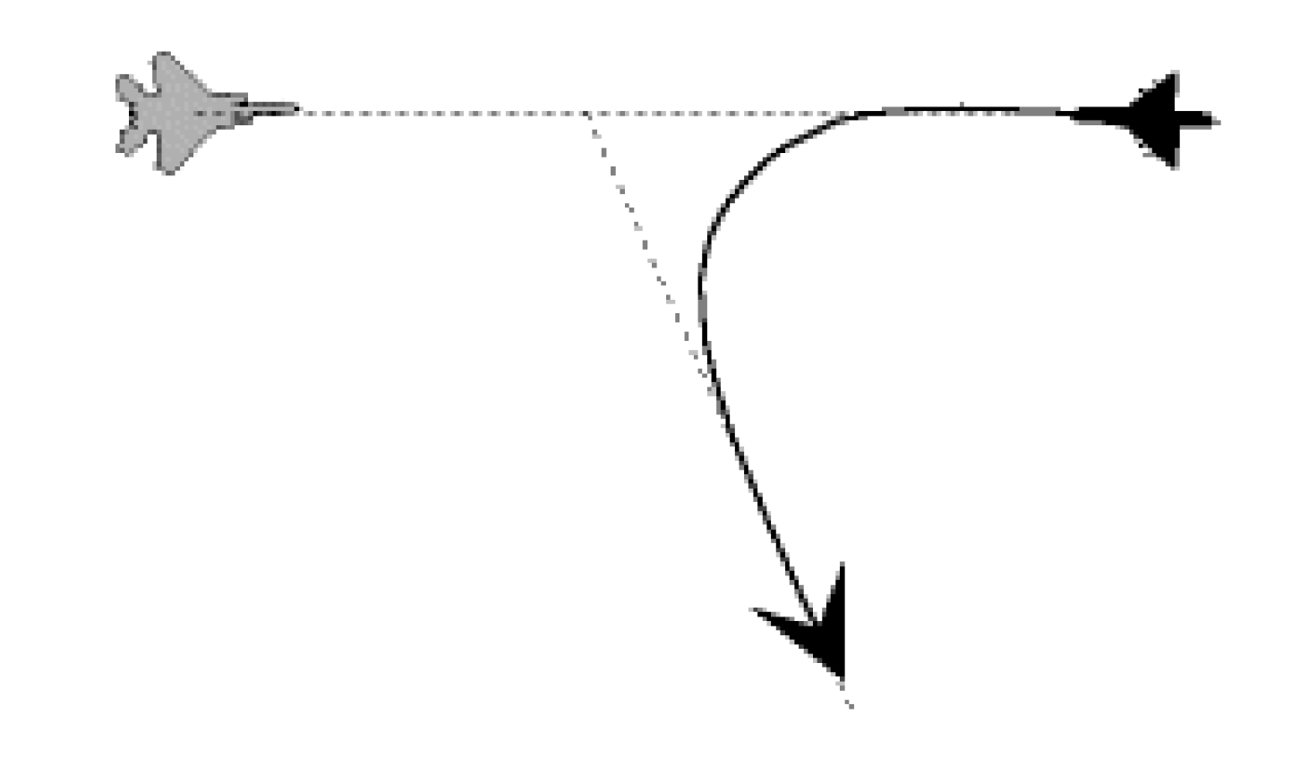
Cranck
Directive/descriptive call indicating an F/A -POLE maneuver in a specific direction (applies to friendly fighters).
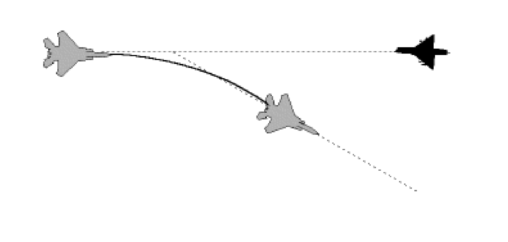
Notch
Description of an aircraft maneuvering defensively to position the bandit on the aircraft’s wingline. (applies to friendly fighters).
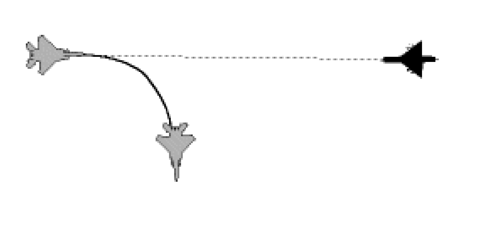
Pump
Directive/descriptive call indicating the fighters are maneuvering up to 180° away from the threat with the intention of recommitting, depending on the tactical situation (applies to friendly fighters).
While pumping, pilots expect picture updates by wingmen or controllers.
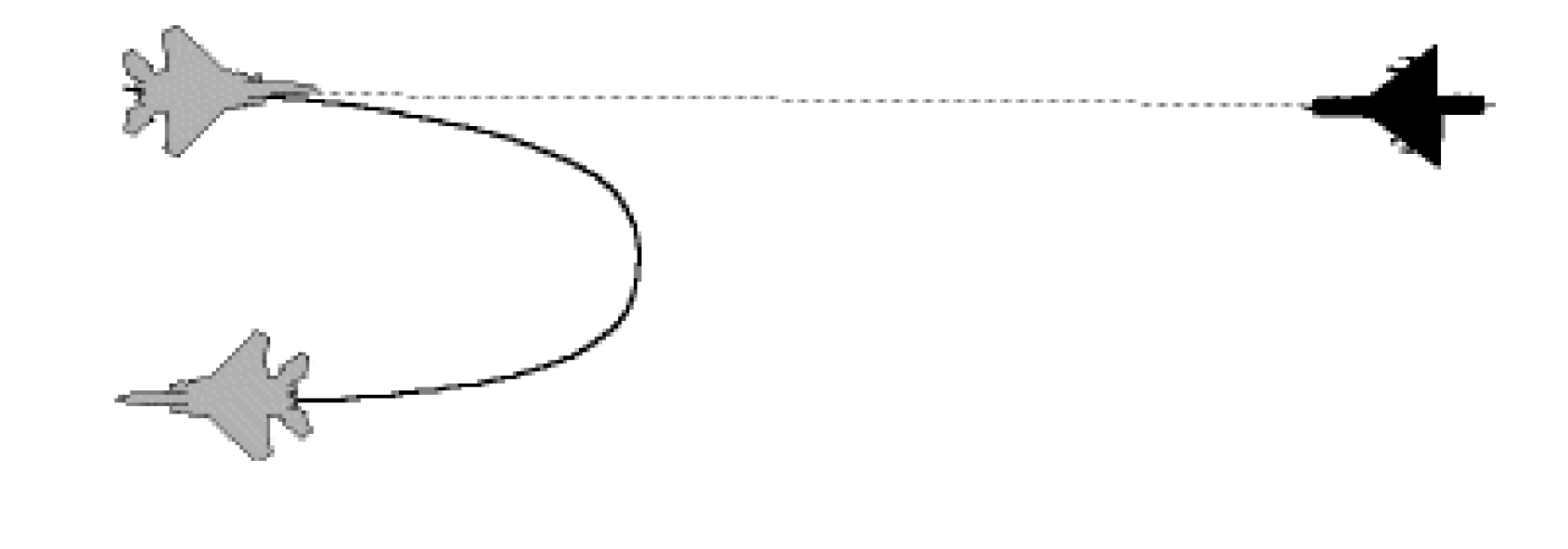
Extend (Direction)
Directive to gain energy and distance with the possible intent of re-engaging.
When extending, pilots require a picture update in order to plan their return into the fight.
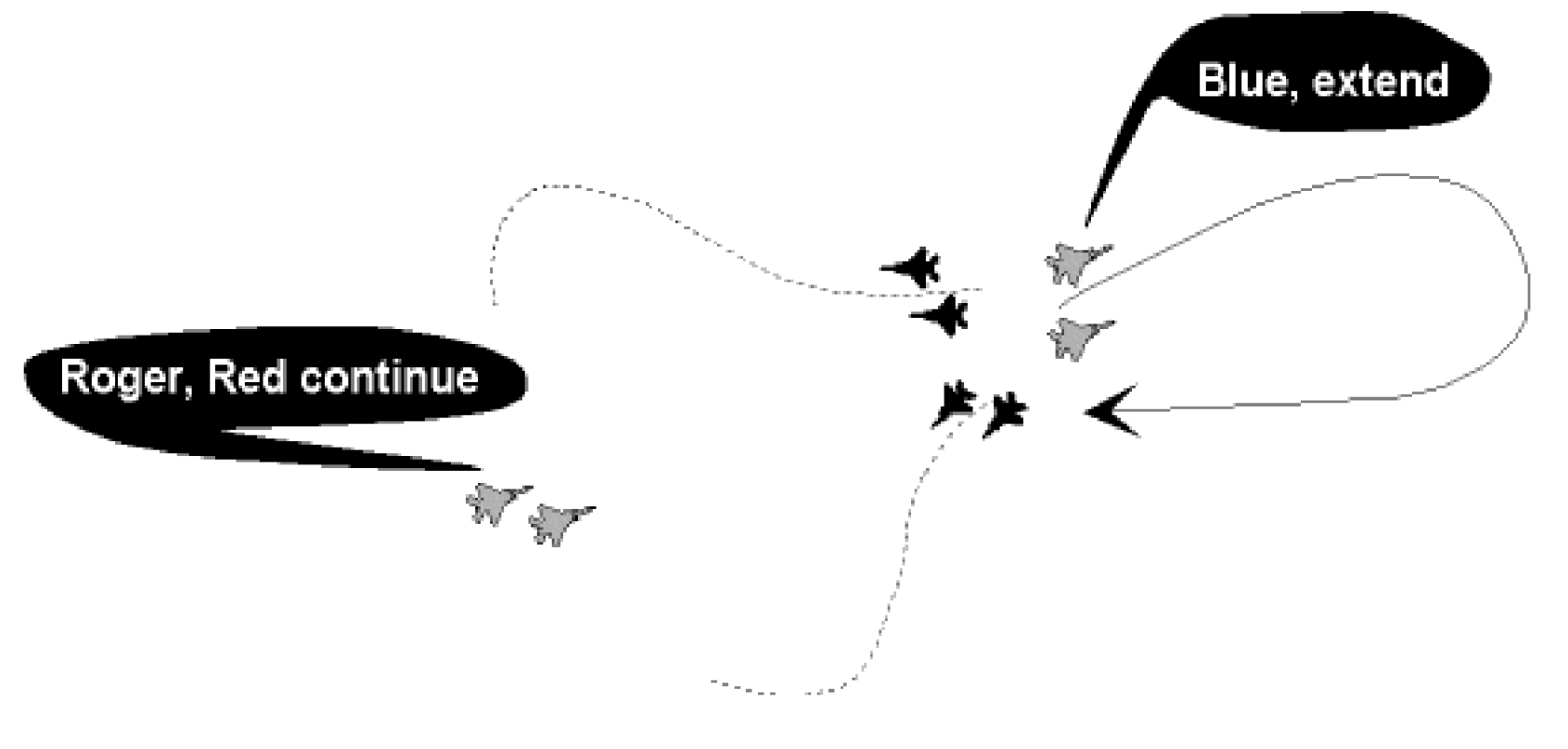
Pacman
Informative call that the fighters have found the end of the threat package and are converting — given in B/R from the FAOR (Fighter Area Of Responsibility) reference point.
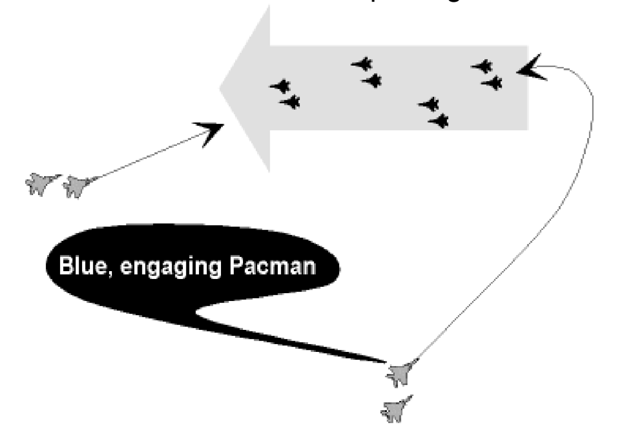
7-Tectical Brevity Words
Diese Seite befindet sich derzeit im Aufbau. Einige der angebotenen Inhalte können unvollständig sein oder Fehler enthalten.
| Word | Meaning |
| ABORT(ING) | Cancel/action/event mission, or, I am unable to continue mission. |
| ________ABOVE | Target is at a specified height above the fighter. |
| ACKNOWLEDGE | Confirm you have received and understood the last message. |
| AFFIRMATIVE | Yes, That is correct. Permission granted. |
| AIRBORNE | Aircraft is flying. I am in flight. |
| ALPHA CHECK | Request for bearing and Range to prebriefed/described point. |
| ALTITUDE |
Vertical distance (height) of aircraft in feet above mean sea level (AMSL). |
| ANCHOR |
Orbit about a specific point; ground track flown by tanker. Information call indicates a turning engagement about a specific location. |
| ANGELS | Altitude of friendly fighter in thousands of feet. |
| ANYFACE | Airborne Early Warning (AEW) aircraft. |
| AS FRAGGED | Fighter, mission package or agency will be performing exactly as stated in the ATO |
| ASPECT |
Request/comment regarding target aspect information. HEAD aspect 160° TO 180°
|
| ASPECT ANGLE |
The angle between the longitudinal axis of the target (projected rearward) and the line-of-sight to the fighter, measured from the tail of the target. The attackers heading is not a consideration. (Whenever the attacker is pointed at the bogey, angle-off and aspect are the same.) |
| AUTHENTICATE |
A challenge and response (in code) to confirm the validity of command instructions or information. |
| AVOIDING ACTION | Directive used by controller when ordering immediate maneuver to avoid a collision risk. |
| ____ AWAY | Weapons indicated has been fired/released. (e.g. Fox One away) |
| (*) AZIMUTH (SPLIT) | Two or more groups primarily separated in bearing from a Fighter point of view. To use to describe Wall, Champagne... formations) Do not use the term “split” any more. |
| (*) BANDIT (S) | Aircraft identified as enemy. According to the ROEs, the term does not necessarily imply direction or authority to engage. (i.e. flying beyond the FLOT within enemy airspace). |
| BASE | Home airfield or specified recovery base. |
| BASE (+ NUMBER) | Reference number used to indicate such information as heading, altitudes, fuel... |
| BEAM |
Aspect of an attack or approach with a Heading Crossing Angle of between 60 and 120 degrees. |
| BEARING |
Direction of an object from another object or point (measured in degrees). |
| (*) BEARING (+ cardinal) | Inner group formation with the trailer displaced approximately 45 degrees behind the leader |
| ______BELOW | Target is (at a relative height) below the fighter. |
| BENT | Equipment/System/Ordnance indicated is inoperative. |
| BINGO |
Fuel state which prohibits safe continuation of present Mission and needed for recovery |
| BLIND | No visual contact with friendly aircraft in the formation. (Opposite of "Visual".) |
| (*) BOGEY | A radar or visual air contact whose identity is unknown. |
| (*) BOGEY DOPE XXX |
A request for bearing/angle and range to Bogey XXX, and as available, heading, altitude and speed. |
| (*) BOGEY DOPE |
A request for bearing/angle and range to the closest target and as available altitude and aspect. |
| (*) BOX | A picture label describing four distinct GROUPs with two in front and two behind in a square or offset square orientation from god’s eye view. (equivalent within a group is CONTAINER) |
| (*) BRAA |
Form or format of tactical control providing bearing, range, altitude and aspect from fighter to target. Aspect is only required if other than HEAD |
| BRACKET |
Simultaneous attack on enemy from opposite sides/altitudes. Directive call to maneuver fighters on opposite sides laterally or vertically from the targets. |
| BREAK RIGHT/LEFT | Directive to perform an immediate maximum performance emergency turn.. |
| BREAKAWAY (HEADING) | Directive to maneuver to achieve horizontal (or vertical) separation |
| BROADCAST | Request/directive to switch to Broadcast Control, ie. GO BROADCAST. |
| BULLSEYE |
An established reference point from which the relative position of an aircraft can be transmitted. |
| BUZZER | Electronic communications jamming. |
| BVR (BEYOND VISUAL RANGE) | A missile fired at a target which is not seen by the pilot. Pilot has radar or IR lock and elects to fire. Identification is not required. |
| CANCEL | Annul the previously transmitted message or clearance. |
| CAP | Combat Air Patrol. |
| CHAFF |
|
| (*) CHAMPAGNE | A picture label describing 3 distinct GROUPS with 2 in front and one behind from a God’s-eye-view. |
| CHATTERMARK |
Start communications jamming countermeasures (use briefed radio procedures to counter comjam). |
| CHECK (ALTITUDE/ANGELS/FUEL/ ASPECT.) | A directive call to carry out check requested or prebriefed procedure; request for target aspect information. |
| CHECK (direction or |
Change to indicated heading or alter heading by degrees) a specified number of degrees left or right for prebriefed time period, then resume heading |
| CHECK WEAPONS SAFE |
Assure that all arrangement switches are in the Off/Safe/Cold/Training positions.(See also; ARM SAFE/HOT.) |
| CLEAN (1) | No radar contact. |
| CLEAN (2) | No external fuel tanks or weapons stations. |
| CLEAN (3) | My RWR shows that I am not being tracked by an aircraft AI radar CW illuminator. E.g “NATO 52, clean”. May be used by friendly aircraft before firing a missile. (See Locked and Spiked) E.g “Blue Lead Locked”. “Roger, 2 clean”. |
| CLEAR (direction) | Aircraft is in immediate danger. Fly in the direction indicated for safety. |
| CLEARED (HOT) | Authorised to proceed under conditions specified. Air-to-surface range attack is authorised. |
| CLIMB (ING) | Ascend; gain altitude. Aircraft gaining height. |
| CLOSING | Range decreasing. |
| CODE | IFF/SIF setting for a particular mode. |
| (*) COLD |
1- A descriptive/directive call to initiate a turn in the CAP away from the threat. 2- Groups heading away from friendly aircraft. |
| COMAO |
COMbined Air Operation. A large number of aircraft of different types and roles working together to perform a mission. |
| COMMIT |
Directive from flight leader to nominated flight member to intercept a specific target. (Air Combat, Sweep, Escort Mission) with no intent to kill. |
| CONFIRM | Have I correctly received the following ....? or, did you correctly receive this message. |
| CONTACT | 1. Interceptor pilot has radar and/or IP (IFF) contact. 2. Directive to make an RT call to another agency or Controller on a designated radio frequency, 3. Controller has radar/IFF contact on his aircraft or bogey. |
| (*) CONTAINER | Inner group formation with 4 contacts orientated in a square or offset square from a god’s-eye-view |
| CONTINUE | Continue left or right turn, climb, descend or maneuver as directed. |
| CONTRAIL(S) |
Condensation trail(s). Crystallized vapor trails left by an aircraft. Aircraft indicated is leaving contrails. |
| CORRECT | That is correct. |
| CORRECTION |
1. An error has been made in this transmission. Transmission will continue with last word correctly transmitted. |
| CRANCK |
Directive / descriptive call indicating an F/A -POLE maneuver in a specific direction (applies to friendly fighters). |
| CROSS TURN | A 180° heading reversal by a flight where aircraft turn into each other. |
| CROSSING_____ TO_____ | Target or Stranger is passing from left to right, or right to left, ahead or behind. |
| (*) CYCLOPS | Any UAV |
| DARK | The designated aircraft is no longer visible on my radar screen. e.g “Target dark” |
| DECLARE |
Request for identification of a correlated target . Responses include: " FRIENDLY / BANDIT / BOGEY / HOSTILE or UNABLE " . |
| DECOY |
Any one of a number of tactics using a single fighter or flight to lure the opposition into a situation where they can be attacked by previously undetected fighters. |
| (*) DELOUSE |
Directive call to detect, identify, and engage (if required) unknown aircraft trailing friendly aircraft |
| DEPARTING_____ | Informative call made on departure from a place or facility. e.g. "Departing Tanker". |
| (*) DEPLOY | Directive to maneuver to briefed positioning. |
| DESTROY | Directive to demolish or nullify a specified target. |
| DESTROYED | Target demolished or annihilated. |
| DESCEND (ING) | Lose height to that specified. Aircraft maneuvering to lower altitude. |
| DISENGAGE | Discontinue the current attack. |
| DISREGARD | Consider the transmission as not sent. |
| DIVERT | Proceed to alternate base. |
| DRAG/DRAGGER | Target maneuvering to 60 degrees or less aspect. |
| DRAG (+ direction) |
Description of the BOGEY/BANDIT maneuvering to position the fighters within + 60° of the Bogey/bandit’s tail |
| (*) DROP (PING) |
|
| (*) ECHELON (direction) |
Picture label/fill-in describing two GROUPs with one group displaced behind and to the side of the other group. |
| ELEMENT | A flight of two fighters acting as a unit. |
| EMERGENCY |
Distress. Serious aircraft/aircrew problems. Also, a setting of IFF/SIF or VHF/UHF frequency. |
| ENGAGE | Descriptive/directive call indicating maneuvering with the intent to kill. |
| ENGAGED |
Aircraft or element is occupied in combat for kill with the enemy. (Controller will provide threat or safety information.) |
| ENGAGING | Entering into combat with the intent to kill. |
| ESCORT |
Fly at safe distance from designated aircraft and provide honour guard and/or protective cover. |
| ESTIMATE | Approximate information (based on judgement). |
| (*) EXTEND | Short term maneuver to gain energy, distance, or separation normally with the intent of re- engaging. |
| FADED | Contact has disappeared from radar but may reappear. |
| FAST | Estimated speed of target, usually between 400kt and Mach 1 or as indicated in ROE |
| FEET DRY/WET | Flying over land/water. |
| FEW | Not many (usually 2 to 4) |
| FLAME OUT | Engine failure. |
| (*) FLANK |
Description of the bogey/bandit maneuvering to an aspect of 120 to 150 degrees angle from tail or 30 to 60 degrees angle from nose of aspect. |
| (*) FLASH |
Temporarily activate specified system for identification purposes IFF/afterburner/flare/chaff/etc.). |
| FOX ONE | Launch of radar guided missile. |
| FOX TWO | Launch of infra-red guided missile. |
| FOX THREE | Launch of active radar missile (AMRAAM, MICA) |
| FOX FOUR | Bomber gunner has fired on a target. |
| FRAG |
The fragment or portion of an Air Task Order (ATO) which holds the tasking details for a squadron or base. |
| (*) FRIENDLY | A positively identified friendly aircraft or ground position. |
| FRONT (FRONTAL) |
An attack or approach with a Heading Crossing Angle (HCA) of between 120 and 180 degrees. |
| (*) FURBALL |
Descriptive/informative call indicating known non-friendly aircraft and FRIENDLY aircraft are in close proximity to each other. Can be a response to a DECLARE request. |
| GADABOUT | Upper limits of height sanctuary for fighters in the MEZ, in thousand of feet. |
| GADGET |
Fire Control System/Radar/Emitter equipment. Gadget 1 = Pulse Radar Gadget 2 = Pulse Doppler Radar Gadget 3 = Air Data Computer e.g. "Gadget 2 Bent". |
| (*) GINGERBREAD | Voice imitative deception is suspected on this net. |
| GO HEAD | Proceed with your message. |
| GO SECURE | Activate secure voice communications. |
| GO TACTICAL | Aircrew is requesting Bearing/range information from nose his own aircraft location. |
| GOODWILL | Boundary of a MEZ. |
| (*) GOPHER | A bogey that has not conformed to safe passage routing, airspeed, or altitude procedures. Will only be used when safe passage routing procedures are part of an ID matrix |
| GORILLA | Large force of undetermined numbers and formation. |
| GREEN SECTOR____ | Direction determined to be clearest of enemy air-to-air (Direction) activity. |
| (*) GROUP |
Descriptive call of several radar targets/contacts within 3nm and 20,000 feet., depending on the general picture. |
| GUNS | Term for simulated guns shot. |
| GUN KILL | Air to air guns shot. |
| HARD (LEFT/RIGHT) | Maximum ‘G' energy sustaining turn. |
| HARDWALL | Impassable limit of an area. E.g., when 2 adjoining FAOR are active, the common line should be HARDWALL. Usually a buffer zone of 5nm is applied and the IC should warn the pilots flying towars. “Mansoor A, HARDWALL 5 miles”. |
| (*) HEAD |
Approaching target or aircraft opposite directions with a stable aspect of approximately 180 degrees. (See also: FRONT.) |
| (*) HEAVY | Group with 3 or more contacts. |
| HIGH | Estimate target altitude between 25,000 to 50.000ft |
| HOLD FIRE |
Do not open fire, or cease fire on raid/track designated. Missiles in flight must not be permitted to continue. |
| HOME PLATE | Home airfield. |
| HOSTILE |
A contact or an intercepted mission determined to be enemy. Aircraft that has committed an hostile act. Clearance to fire is authorised IAW theatre ROE |
| HOT |
1-High aspect target. (160-180 degrees angle from tail or 0-20 degrees angle from nose. 2-A call by a fighter on CAP that he is turning onto a heading towards the threat where he can search for targets. e.g “Tiger22, turning hot”. 3-Defined area is expected to receive fire (enemy or friendly). |
| (*) ID / IDENTIFY | Directive to intercept and identify the target or I.D. accomplished, followed by type of aircraft. |
| (*) IN (opposite OUT) | Informative call indicating a turn to a hot aspect relative to a known threat. |
| INTERCEPT | Directive to intercept target and carry out specified task. |
| (IN THE) DARK |
Not visible on my scope and any position information is estimated. |
| IN TRAIL | Perform maneuver maintaining relative position in formation. (See: TRAIL.) |
| INVESTIGATE | Search and report. |
| JINK |
Perform unpredictable maneuvers to escape/ elude enemy radar lock-on, air-to-air or surface-to-air weapon. |
| JOKER | A pre-briefed fuel state before Bingo. |
| JUDY |
1. Pilot has radar lock on and assumes responsibility for intercept. The controller will acknowledge and will cease giving information except threat calls or flight safety awareness. Controller will closely monitor the intercept and be ready to pass information/commands if the fighter calls "Bogey Dope" or "More Help". 2. Used by a fighter to indicate a radar lock on when rejoining with a friendly fighter. No further assistance is required from GCI (but see above). |
| KEEP CLEAR _______ | Keep clear of contact bearing ___/___miles from me or reference point. |
| KICK | Change to Frequency _____, or Push number. |
| KICK (direction) | Informative/directive call indicating a defensive “Check” turn in a specified direction. |
| KILL |
1. Directive to destroy a specific airborne target. 2. Confirmation of act of destruction or disablement of airborne target. |
| KNOCK-IT-OFF |
Training directive used to terminate the intercept/engagement in progress. Repeated 3 times. Used for an emergency termination of an ACT engagement. |
| KOBOLT | MEZ is not in operation. |
| (*) LADDER | A picture label describing three or more groups separated in range. |
| (*) LEAD TRAIL |
Relative position within a group of the leader and wingman following each other and less than 3nm |
| LEAKER |
Aircraft, part of an engaged raid, which flew through the defensive layer and continues toward its target. Leakers become higher priority of engagement. |
| LEVEL | Fighter/Aircraft is at the designated angels/ altitude or, target is at the same altitude. |
| LINE ABREAST | Wingman is at right angles to lead ±5000 feet and 1 to 3 miles displacement. Also called the Battle Formation; can be formed using 2, 3 or 4 aircraft. It is a defensive formation, providing good visual cross cover but sacrificing some maneuverability compared to offensive formation; it is used when entering or departing in area or when on CAP. |
| (*) LINE ABREAST |
Relative position within a group of the leader and wingman on the wing line and less than 3nm. |
| LOCK-ON/LOCKED | Fighter has final A.I. radar lock-on. |
| LOOSE | That type of control where the pilot is responsible for conducting the mission. The controller provides only the Air Picture, without any command or orders. It consists of Bullseye calls, bearing and range only, or even a geographic location call on guard. |
| LOW | Target altitude low, usually between 500 ft to 5,000 ft |
| MAINTAIN | Hold designated altitude, speed or heading. |
| (*) MANEUVER (ING) |
Aircraft in turn, aspect is impossible to define. When aircraft is steady, then aspect must be broadcast. |
| MANY | More aircraft (5 or more) than can be clearly distinguished. |
| MARSHAL (LING) | Rendezvous / aircraft are joining. |
| MAYDAY | International distress call. Usually called three times. Immediate assistance required. |
| MEDIUM |
Target altitude estimated between 5,000 to 25,000 ft. DO NOT USE FOR SPEED! |
| (*) MELD | Directive call to adjust radar scan volume to cover the same target group. |
| MERGE (D) |
Radar responses have come together, individual aircraft cannot be identified. |
| MIX UP | Hostile and friendly, target and fighter radar responses have merged. |
| MODE | IFF operating selection. |
| MONITOR | Listen-out on.... (frequency designator/stud) |
| MONITOR |
Directive or request indicating that are intentionally disregarding a bogey / group while attention is focused on another. Task you / wingmen to watch that bogey / group and advise if it is about to become a factor of threat. Do not use instead of "shadow" |
| MORE HELP | See Bogey Dope. |
| MOTHER | Parent ship, usually aircraft carrier. |
| MUD (B/R) | Indicates unknown RWR ground threat displayed. |
| NEAR | When describing groups/contact/element in range, indicates the closest to the fighters. |
| NEGATIVE | No. That is not correct. Permission not granted. |
| NEGATIVE CONTACT | No radar and/or SIF contact. |
| (*) NO FACTOR | Group, aircraft do not present immediate threat. |
| NO JOY (1) |
Aircrew does not have visual contact with target/bandit; opposite of "TALLY". |
| NO JOY (2) |
I could make no contact on the designated frequency. E.g “NATO51, back with you, no joy channel 5”. |
| NOTCH (ING) |
Description of an aircraft maneuvering defensively to position the bandit on the aircraft’s wing line. |
| OFF (HIGH/LOW/LEFT/RIGHT________O'CLOCK | Attack is terminated or completed and aircraft is repositioning or exiting as stated. In clock code section and at range indicated. |
| OILFIELD | MEZ in operation, active. |
| ON STATION |
I have reached my assigned station and I am operational. Opposite of OFF STATION |
| ORBIT/ORBITING LEFT/RIGHT) | Circle in direction indicated. (See also: Anchor.) |
| (*) OUT | CAP fighter(s) back(s) the threat sector to reset whilst the other CAP aircraft is IN. |
| PACKAGE | Geographically isolated collection of groups. |
| PACMAN | Informative call that the fighters have found the end of the threat package. |
| (*) PAINT |
An interrogated group/contact that is responding with any of the specified IFF modes-codes established for the ID criteria. |
| PAN, PAN | Calling station has a very urgent message to transmit concerning the safety. Preferably said three times. Plus a message to indicate the nature of assistance required. |
| PARROT | Military IFF/SIF equipment. |
| PICTURE |
Situation briefing which includes real time information pertinent to a specific mission (general air situation, Order of Battle...). Call from fighter to indicate he requires an update on the tactical air situation. E.g. “Nahyan, Shaheen Blue, picture” - “Shaheen Blue, picture, 2 CAPs manned, Shaheen Green on CAP 1, Shaheen Blue CAP 2,. Tanker on Towline Alpha, Clara”. |
| PIGEONS | Magnetic bearing and range to home base or to a specified point. |
| PINCER |
A tactic where two aircraft or flights separate in an attempt to bracket the enemy and attack from opposite sides simultaneously. (See also: RUMS, Bracket,Hooking) |
| PIREP | Pilot reported weather conditions. |
| (*) PITBULL | Informative call from the pilot stating that the missile is now active, inbound the target. Because the fighter is breaking away, there is no way for him to know if the target is hit and disappear. So the controller should check if, after 20 seconds, the target is still alive and inform the pilot. |
| PLAYMATE | Friendly ship, craft or aircraft with which I am co-operating. |
| PLAYTIME | Amount of time an aircraft can remain On station. |
| POGO |
Return to this frequency if you have no contact on the designated frequency or channel. E.g “NATO51, channel 5, pogo”. |
| (*) POP-UP |
A radar contact which has suddenly appeared at close range. In Picture Building, Popup threat must be broadcast in tactical when appearing within 20nm. |
| PORT | Directive requiring aircraft to turn to the left. May specify a heading or a number of degrees. |
| (*) POSIT |
Request for position; response normally in terms of a geographic landmark, or off a common reference point. Posit is the preferred term for positioning friendly fighters between each other. |
| (*) PRESS |
A maneuver where a fighter puts himself into a position against a target where the target is forced to make a hard turn, thereby using up speed and energy. E.g. “2, press”. “Roger, 2 in hot”. “Roger, 1 out, extending”. |
| PUMP (ING) |
Directive/descriptive call indicating the fighters are maneuvering up to 180° away from the threat with the intention of recommitting, depending on the tactical situation. |
| PUSH |
Call by a formation leader that the formation should depart their present frequency for the next frequency. E.g. “Puma 21, push channel 2” |
| PUSH (ING) | Directive/informative call indicating the offensive strike (COMAO) has reach the Time (Push time) and the Point (PUSH point) to start the Ingress towards the enemy target area. |
| RADIAL | Aircraft's magnetic bearing from a Tactical Air Navigation (TACAN) station. |
| RANGE | Distance in nautical miles. |
| (*) RANGE (SPLIT) |
Two or more groups primarily separated in distance along the same bearing. Do not use the term “split” any more.
|
| REPORT | Pass requested information. |
| RESCAP |
Rescue Combat Air Patrol, provides protection to vehicles from hostile forces during all phases of SAR. |
| RESET | Aircraft return to CAP. |
| RESET | SSR/SIF Mode/Code not correct or not decoding, reselect mode and/or code. |
| RETURNING | Informative call indicating the fighters are returning to CAP. |
| ROGER | I have understood your last transmission. |
| ROLEX |
Informative/directive call indicating a time change in minutes from a given datum. (the term “plus” will indicate later time and the term :minus” will indicate an earlier time.) |
| ROLL OUT | Do not turn as far as previously directed; roll out of turn on heading now specified. |
| RTB | Return to base. |
| RULES OF ENGAGEMENT (ROE) | Rules and safety criteria by which all players must abide. They are different for each major command, but the strictest ROE must be observed for the whole mission. |
| SAFE | Not armed. Non-active condition. (See: ARM SAFE/HOT) |
| SAFE (OR SANCTUARY) HEIGHTS | Altitudes aircraft must be at when within 10 miles of the adversaries with no Tally; to avoid being co-altitude. When Tally, the fighters may go to separation altitudes as specified in the ROEs. |
| SAME |
Informative reply indicating that the aircrew/controller has the identical radar contact/status as was just stated. |
| SANDWICH | A situation where a fighter is attacking an enemy, however, a fighter is also being attacked by a second enemy; i.e., a condition where an offensive advantage is negated by positioning the defender's wingman behind the offensive fighters. A multiple sandwich is often called a Daisy Chain. |
| SANITIZE | Perform a radar scan in given direction and report to Flight Lead |
| SAY AGAIN | Repeat entire message, or specific item. |
| SET SPEED_____ | Adjust speed to stated Mach/knots. |
| SHACKLE | One weave, a single crossing of flight path. |
| SHADOW | Directive to closely follow designated target;implies remaining unobserved. |
| SHEPHERD | Use recognised procedure to conduct the intercepted aircraft as directed. |
| SHINING |
Informative call indicating that a fighter is radar locked on to the Bogey. Further details of heading, bull’s eye position or angels may be necessary. |
| SINGLE | One object (aircraft, ship, contact....). |
| SITUATIONAL |
The aircrew/controller's ability to comprehend all facets of AWARENESS (S.A) an intercept/ engagement to include present and projected spatial relationships between his aircraft and all opposing aircraft. |
| SKIP IT |
Disregard the indicated contact or target. E.g “MAGIC, Tiger Blue, contact 080/60”, “Roger Tiger, skip it, your target 110/75”. |
| SLOW | Any detection with a ground speed of between 200 to 400kts. |
| SLOW |
Estimated aircraft speed less than M 0,6 or 30 SNAP (vector). A quick vector to the engagement or nearest bogey. Normally used when a pilot momentarily loses visual contact with the fight and needs directions to get back to it. |
| SNAPSHOT |
A high angle off gun shot with little chance of success because the target is in gunsight only momentarily. |
| (*) SORTED | Sort responsibility within a group has been met |
| SPIKE (D) |
Informative call of a RWR indication of a Hostile AI radar lock-on. My RWR shows that I am being tracked by an aircraft AI radar CW illuminator. E.g “Tiger Blue, spiked, 080/10. |
| SPLASHED | Enemy aircraft shot down. (Followed by number and type). |
| SPLASH (ED) | Training term for simulated destruction or kill. |
| SPLIT (ING) | Contact/flight is separating. Directive to separate. |
| SPOOFING | Informative that voice deception is being employed. |
| SQUAWK (-) CODE (-) | Operative IFF/SIF transponder as instructed. |
| SQUAWKING_____ | Operating IFF/SIF in Mode an Code indicated. |
| SQUAWK STANDBY | Directive to switch off IFF. |
| (*) STACK |
Two or more contacts, or formations with a high or low altitude separation in relation to each other within group criteria. |
| STANDBY |
1. Wait, wait for instructions 2. State of IFF equipment. (See Squawk Standby) |
| STARBOARD | Directive requiring aircraft to turn to the right. May specify a heading or number of degrees |
| (*) STATUS |
1. Request for an individual’s tactical situation. 2. (Group) Request for a full positional update in digital Bullseye format on the specified group. |
| STEADY | Aircraft is on prescribed heading. |
| STERN | Request for, or directive, to intercept using stern geometry. |
| STINGER | Formation of three or more aircraft with single in trail. |
| STRANGLE | Turn off equipment indicated, ie. Stop Buzzer; Strangle Parrot. |
| STRANGER |
Air traffic in close proximity which is not a threat, nor a participant in a mission, but which might represent a flight safety hazard. |
| SWEEP | Aircraft tasked with entering an area for the purpose of achieving air superiority. Purely offensive in nature. |
| (*) SWEET | Equipment indicated is operating efficiently. |
| SWITCH | To break off an attack on one enemy in favour of attacking another. |
| TACTICAL |
Range and bearing centred on the position of the designated fighter. E.g. “Chivas Bravo, target, tactical, 245/65NM”. |
| TALLY |
Visual contact with target/bandit. Controller to continue to pass target information. |
| TALLY-HO |
Visual contact with Bandit/Target. Pilot taking over the interception. Controller stops passing target information. |
| TARGET | Inclusive word used to describe any aircraft being Intercepted during an air defence exercise. |
| TERMINATE |
Repeated three times. A routine termination of an ACT engagement. E.g. “Terminate, terminate, terminate”. |
| TEXACO | Tanker aircraft. |
| TIME HACK |
Informative broadcast call to remind crews to change rotating IFF mode in accordance with COMPLAN/SPINS. |
| TIME CHECK | Request for time synchronisation signal. |
| TRAIL | Formation of two or more aircraft following each other. |
| TRAILER | The last aircraft in formation. |
| UNABLE | Cannot comply as requested/directed. |
| VECTOR | Directive to turn to heading indicated. |
| VERY FAST | Any detection with a ground speed of more than Mach 1. |
| VERY HIGH | Estimated altitude above 50 000 feet AMSL. |
| VERY LOW | Any detection flying below 500 feet. |
| VERY SLOW | Any detection with a ground speed of less than 200 knots. |
| VIC | Three groups with the single closest in range and an element in trail. |
| VISUAL | Visual contact with friendly aircraft. |
| VISUAL IDENTIFICATION (VID) | Visual Identification of a bogey to determine if he is hostile. |
| (*) WALL | Three or more groups line abreast/side by side. |
| WEAVE | Two fighters, or elements, continually crossing each other, then reversing and re-crossing. It is used to increase the radar and visual coverage of the fighters by looking both straight ahead and out to the sides. Also used to confuse the enemy radars. |
| (*) WEDGE |
Tactical formation of 3 or more aircraft, within a group, with the single in front and the other aircraft laterally displayed on either side behind the leaders wing-line. |
| WHAT LUCK | What are/were the results of assigned mission? |
| WHAT STATE | Report fuel and weapons configuration in accordance with procedures/directives. Used with approved codes. |
| WILCO | Received your message, understand and will comply. |
| ZIPLIP | Hold UHF communications to a minimum (MINCOM) |
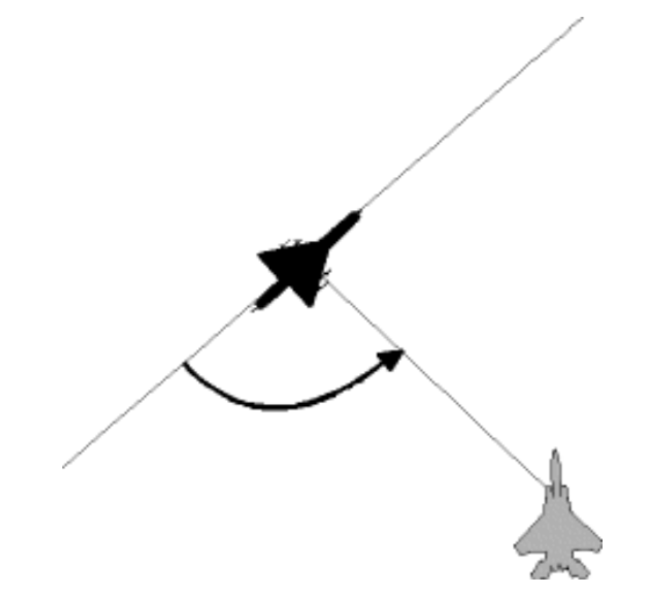
8-QRA Mission
Diese Seite befindet sich derzeit im Aufbau. Einige der angebotenen Inhalte können unvollständig sein oder Fehler enthalten.
Introduction
Quick Reaction Alert (QRA) is a state of readiness and responsiveness maintained by air forces and other military bodies worldwide. Its purpose is to deter, detect, and counter threats promptly. When the order to take-off (scramble) is triggered, the alert aircraft (single or in pair) have a minimum delay to take-off. Therefore, they have to be prioritized over all other traffic.
Alert Status
Alert Status is preset and must be published 2mn, 5min, 15min, 30min or 1 HR). It is the delay between the scramble order and the effective take off of the QRA asset.
Scramble
The scramble is the code word for the order to take-off. It is received by the pilot directly from the Scramble authority.
Scramble Authority
In Real World, the scramble Authority for QRA is the AOC (Air Operation Center).
In Simulation:
- During an exercise the authority is designated in the exercise documentation ( SPINS, COMPLAN)
- Outside an exercise, the scramble Authority can be the ATC online controller i.a.w. VSOA PPM v4.0
Interception
Target designation
QRA is not a war or combat action, therefore all communication are not subjected to the usage of Brevity words and codewords, except those commonly used during training sorties.
After the pilot has checked in, the controller must provide the following target information
- Target Classification (BOGEY or AIR ASSISTANCE)
- Target position (BRA)
- What is the first measure ( EID, ESCORT or else)
- Any additional info in clear
Method of Control
Depending on the controller’s qualification or the mission requirement, different methods of control can be provided. The following is applicable in all cases, whether you fly in OAT IFR, VFR or TACTICAL and not only for QRA sortie.
| Method | Responsibility | Description |
| CLOSE POSITIVE | MISSION --> CONTROLLER SAFETY --> CONTROLLER |
In a Close Positive control sortie, controllers are responsible for mission completion and for keeping the safety separation :
|
| LOOSE POSITIVE | MISSION --> PILOT SAFETY --> CONTROLLER |
In a Loose Positive control sortie, the controller transmits only information to the pilot, with no commands. Pilot is responsible for the mission completion but controller remains responsible for keeping the safety separation :
|
| CLOSE ADVISORY | MISSION --> CONTROLLER SAFETY --> PILOT |
In a Close Advisory control sortie, controllers are responsible for mission completion while pilot is responsible for his own flight safety. |
| LOOSE ADVISORY |
MISSION --> PILOT SAFETY --> PILOT |
In a Loose Advisory control sortie, the controller transmits only information to the pilot, with no commands. Pilot is responsible for the mission completion and for his own flight safety. |
| BROADCAST | MISSION --> PILOT SAFETY --> PILOT |
The controller will transmit general information and activity within the designated area in the form of Broadcast. The format of the broadcast will depend on the tactical situation. Pilot is responsible for the mission completion and flight safety. |
So this means that:
- if the controller is GCI qualified, you should expect CLOSE POSITIVE control with guidance to the target until you declare the JUDY (Radar contact and locked).
- If the controller is not GCI qualified, he will provide only LOOSE POSITIVE control, entailing that you as pilot are responsible for completing the interception based on his information, with no guidance.
Finale Approach
Always from rear sector and never interfering with target route.
Active Measures
Active measures apply to all aircraft using national airspace, including light aircraft.
They are intended to prevent situations such as a deviation from course, entry into a prohibited zone, lack of communication with air traffic control or technical issue encountered by crews in controlled spaces.
The aim is to strengthen the protection of airspace against aerial threats, whether they are protesting or simply unintentional.
| EID |
Electronic Identification to describe number of contacts, radiations if able
NATO X-Ray, Sunrise, execute EID and report Sunrise, NATO X-RAY, radar contact 1 spot |
| VID |
Visual Identification to describe number and type of a/c, configuration, flight parameters. Pilot must be reminded that the minimum separation is 1000 feet and 1000 meters. NATO X-Ray Sunrise, execute VID and report |
| SURVEILLANCE |
Conservative measure. This is an escort with the minimum separation of 1000 feet and 1000 meters. NATO X-Ray Sunrise, maintain air surveillance |
| VISUAL INTERROGATION |
Visual interrogation to gain more accurate details (Registration, company, persons onBoard, national markings ...). Cleared to close 300 meters. NATO X-Ray Sunrise, execute Visual Interrogation and report |
| RADIO INTERROGATION |
If the bogey is member of a VSO, this measure consists in getting information through radio call. NATO X-Ray Sunrise, execute radio interrogation on frequency 121.500 |
| ESCORT |
Escort is necessary to accompany a plane along its route. NATO X-Ray Sunrise, execute ESCORT |
| DIVERSION |
A diversion may be required to force an aircraft to change its course or to land on a designated airfield.
NATO X-Ray, Sunrise, execute DIVERSION to exit National airspace on heading XXX Or... NATO X-Ray, Sunrise, execute DIVERSION to EDDH, pigeon 185/75 |
| WARNING SHOT |
The warning shot can be executed only on the formal order of a high government authority and must be authenticated. This measure must be followed by a resumption of the previous measure. If no positive attitude after the Diversion order, the bogey may be classified Hostile by high authority.
NATO X-Ray, Sunrise, execute WARNING SHOT, picture is clear, authenticate XBCF |
| DESTRUCTION |
The destruction measure is the ultimate measure It can only be carried out on formal order and after an unsuccessful Warning Shot.
NATO X-Ray, Sunrise, Bogey now HOSITLE, clear to ENGAGE and KILL, picture is clear, authenticate ABCD Sunrise, NATO X-RAY, Hostile splashed |
Chain of Command
Pilot may expect some delay between their last transmission and the measure that will be decided then. This is due to the reports and discussions between AOC and High authorities. Pilot must be accurate in the information transmitted and patient.