EDVE - Braunschweig Airport
Overview
Before staffing this airport for the first time:
Obtain a successful grade at the self enrollment Moodle course: EDVE - Braunschweig-Wolfsburg Tower.
Braunschweig Airport is located north of the city Braunschweig in Lower Saxony, which is between Hannover and Magdeburg. This Airport traditionally has been a major center of gliding in Germany and is also used for general aviation, especially business traffic. It's the major hub of the Volkswagen Air Services and the closest suitable airport for the internationally playing Soccer team VFL Wolfsburg.
The headquarters of the German Federal Aviation Office, the Luftfahrt-Bundesamt are located at the Airport, as well as the Research Fleet of the German Aerospace Center (DLR). The well known "NAV Checker" has its base at EDVE flying out to calibrate navigational stations like ILS and VORs in Germany.
Main Operations, no scheduled public passenger or cargo services:
| VW Air Services | Dessault Falcon 8X and 7X, Pilatus PC-24, A319CJ (retired) |
| Privat Wings | Dornier 328 and Beech 1900D |
| NAV Checker | Beech KingAir 350 |
| Research Fleet DLR | A320 (ATRA), ISTAR, Do 228, DR400, EC BO105 and more |
| Soccer Clubs | visiting the internationally playing VFL Wolfsburg |
| Services | King Air Service Center, Charter Flights, Para jumping, Glider |
Braunschweig ATC Stations
| Station |
Station ID |
Login |
Frequency |
Remark |
| ATIS |
AVE |
EDVE_ATIS |
134.455 |
-- |
| Tower |
VET |
EDVE_TWR |
120.055 |
-- |
|
Arrival |
HAN |
EDDV_APP |
119.490 |
-- |
General Information
EDVE is an unrestricted airport of the Bremen FIR and part of the S1 minor program. Controllers on the vACC Germany Controller Roster are allowed to control at this Airport with their S2 or higher rating after checking these Standard Operational Procedures and obtaining a successful grade at the respective Moodle course: EDVE - Braunschweig-Wolfsburg Tower.
Tower position does not have to track aircrafts.
Quicksheet

Tower
Braunschweig Tower is responsible for all arriving and departing traffic. The top level of the airspace D control zone is 2200ft MSL. Above this altitude and around the CTR airspace E covers the area within responsibility of Bremen Radar (Hannover Approach). A Para jumping Area up to FL100 is directly above the airport.
 Controlzone and VFR Reporting Points of Braunschweig Airport - © openflightmaps.org
Runway and Airport
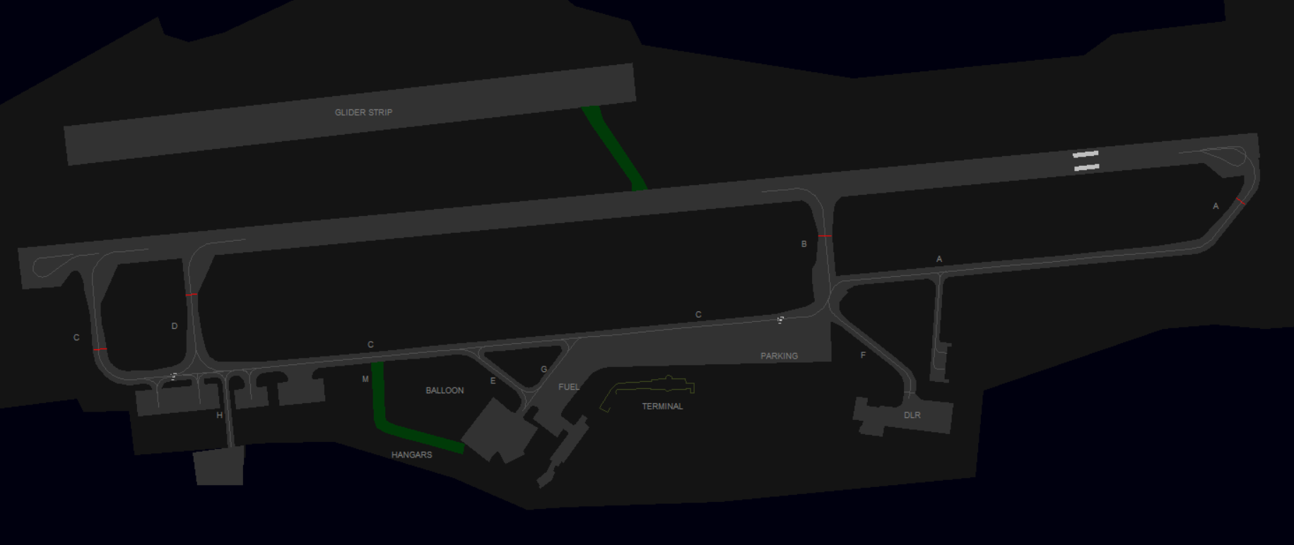
Braunschweig Airport has a 7546ft (2300m) long single runway (08 / 26) with no Low-Visibility equipment, as well as a grass glider strip north of the main runway. The airport features an apron area south of the runway with a main terminal building and various company facilities.
The area limit of ATC competence, which is shown on some charts, is not applicable on VATSIM, as we do not simulate airport operators.
Reduced Runway Separation (RRS)
Braunschweig Airport (EDVE) is approved to apply the following reduced runway separation minima during the day only:
| Runway |
CAT 1 following a departing CAT 1 or 2 | CAT 2 following a departing CAT 1 or 2 | CAT 1 to 3 following a departing CAT 3 |
| RWY 08/26 | 600 m | --- | --- |
Departures
All IFR Departures need a Departure-Release from Bremen Radar! *
Coordinate early enough on TeamSpeak, as you might get a delay time, e.g. at EDDV events.
* If traffic permits, Radar can give a "general departure release until further notice". In that case the tower doesn't need to ask for each departure separately.
Departure Holding points are C (08) and A (26). Airliners usually also backtrack while lining up via C. Intersection D is often used for light aircraft. Intersection B should be avoided due to noise abatement.
Spacing: Departures shall be separated with a minimum of 3 nm or wake turbulence separated, whichever is greater. When two aircrafts have the same SID waypoint the separation shall be increased to 5 nm or wake turbulence separation whichever is greater.
Auto-Handoff: Pilots shall contact Bremen Radar immediately after take-off without a specific handoff.
Arrivals
Unless a pilot request a specific location (e.g. facilities at Taxiway H or F), they should get a taxi instruction leading to the Apron south of C with a stand of choice. Example: "Taxi to stand of choice via A and C"
VFR
Braunschweig offers 4 routes in and out of the CTR at max. 2000ft. Only the outer Waypoints are mandatory reporting points.
| VRP | N1 | E1 | W1 | S |
|---|---|---|---|---|
| NAV | Wedesbüttel north-west of the field | North of Cremlingen close to A39 intersection | A2 east of Peine | Trainline Intersection at Groß Gleidingen |
VFR Routes
|
Route |
Runway 08 Arrival | Runway 08 Departure |
|---|---|---|
| November |
N1 -> N2 (Traffic Circuit 08) |
direct N1 |
| Echo |
E1 -> E2 or directly into right Traffic Circuit 08 |
right Turn E2 -> E1 (or direct E1) |
| Sierra |
S -> right Base 08 |
right Turn direct S |
| Whiskey |
W1 -> W2 (following A2) |
N2 -> W1 (north of Glider area) |
| Route | Runway 26 Arrival | Runway 26 Departure |
| November |
N1 -> right Base 26 |
W2 -> right Turn N1 (avoid glider area) |
| Echo |
E1 -> E2 -> Final 26 |
direct E1 |
| Sierra |
S -> Traffic Circuit 26 |
direct S |
| Whiskey |
W1 -> N2 (right Traffic Circuit 26) |
W2 -> W1 (following A2) |
Early break-out to the North is NEVER approved due to glider area! Use W2/N2 accordingly.
Helicopters
Helipad: The Helipads are not in use. They are turned off via NOTAM for years now. All Helicopters air-taxi to the runway.
Police and Rescue helicopters: Expect Lower Saxony's state police helicopters from the Base in Gifhorn or Hannover (Bundespolizei, Callsign Phoenix) as well as possible crossings from Christoph Niedersachsen (CHX86).
Ground
Parking
Terminal: Braunschweig features one main terminal building at the center part of the Airport. Various company facilities and hangars are based at the main taxiway C.
Airliner Stands: On the main apron in front of the terminal building.
General Aviation: The GAT is east of the Terminal on the main apron with enough space for some GA aircrafts. The Fuel station is west of the Terminal via taxiway G.
Volkswagen Air Service: via Taxiway E/G.
Deutsche Luft- und Raumfahrt: DLR has it's own apron reachable via taxiway F.
Business Aviation Center: - via taxiway K east of F, also referred as Kroschke. On pilot request only, due to outdated sceneries.
De-Icing: No special positions. De-Icing can be ordered at your current stand.
Taxiways
The area limit of ATC competence, which is shown on some charts, is not applicable on VATSIM, as we do not simulate airport operators. Tower maintains control over all ground activities. The main taxiways A-D are suitable for Class C aircrafts. Class D not yet confirmed.
| Taxiway | Notes |
|---|---|
| A, C | Main Taxiway and Holding Points for departure |
| B, D | usually not used for departure, vacate only |
| H | Aircraft may only be towed and requires prior approval |
| L + M | Gras Taxiway only for instructed users (L = between Runway and Gliderstrip) |
| F | DLR private Apron |
| K | Business Aviation Center Kroschke (East of F) |
Delivery
Specials
Vectored departures: The use of vectored departures requires prior coordination with the responsible radar station. An initial altitude to climb shall be provided.
IFR local flights: IFR local flights are coordinated with the responsible radar controller, who may instruct a different departure procedure, possibly vectored departures.
Low Visibility Operations
At Braunschweig, no approaches are certified during low-visibility operations. Departures are allowed to take off if the RVR is not below 300 m.