| **Station** | **Prio** | **Frequency** | **Login** | **SI** | **Remark** |
| **ATIS** | -- | 123.780 | EDDB\_ATIS | ADB | -- |
| **Delivery** | 3 | 121.605 | EDDB\_DEL | DBC | -- |
| **De-Icing** | -- | 121.665 | EDDB\_ICE\_GND | DBI | Only to be staffed when icing conditions exist |
| **Main Apron** | 2 | 121.855 | EDDB\_A\_GND | DBGA | -- |
| Apron North | 4 | 129.605 | EDDB\_E\_GND | DBGE | -- |
| **Tower / Ground** | |||||
| Ground South | 4 | 121.705 | EDDB\_S\_GND | DBGS | -- |
| Ground North | 4 | 129.505 | EDDB\_N\_GND | DBGN | -- |
| **Tower South** | 1 | 118.805 | EDDB\_S\_TWR | DBTS | -- |
| Tower North | 4 | 120.030 | EDDB\_N\_TWR | DBTN | -- |
| **Arrival / Departure** | |||||
| **Pickup South** | 1 | 126.425 | EDDB\_S\_APP | DBAS | -- |
| Pickup North | 3\* | 119.630 | EDDB\_N\_APP | DBAN | -- |
| **Feeder South** | 2 | 121.130 | EDDB\_AS\_APP | DBAST | -- |
| Feeder North | 3 | 136.105 | EDDB\_AN\_APP | DBANT | -- |
| **Departure South** | 2 | 120.630 | EDDB\_S\_DEP | DBDS | -- |
| Departure North | 3 | 120.340 | EDDB\_N\_DEP | DBDN | -- |
\* Note: EDDB\_N\_APP may be staffed without the requirement of Departure to be online. In this case, EDDB\_S\_APP take over all responsibilities for DBDN and DBDS. To staff the DBAN-DBAS split, a Feeder must be online first.
**Extended Service over Berlin Ground:** Berlin Apron should generally not provide extended Service over the Berlin Ground AoR when Berlin Ground is unstaffed. Only in certain situations where it provides relief to the station covering Berlin Tower, the controller covering Berlin Tower may ask Berlin Apron to offer extended service and issue taxi-clearances towards the holding point. This may occur, for instance, when Berlin Tower is being controlled according to the "top-down" principle. This service shall only be provided by seasoned Berlin Apron controllers holding an S2+ rating.
### Generelle Informationen #### Maximum Runway Capacity **06L/24R:** 25 Deps/h, 25 Arr/h **06R/24L:** 25 Deps/h, 25 Arr/h ### Guides **A-CDM at EDDB: [https://dms.vatsim-germany.org/s/odw629qZk5WezPi](https://dms.vatsim-germany.org/s/odw629qZk5WezPi)** **De-Icing at EDDB: [https://dms.vatsim-germany.org/s/akGzoSddntR6DM3](https://dms.vatsim-germany.org/s/akGzoSddntR6DM3)** ### Quicksheet [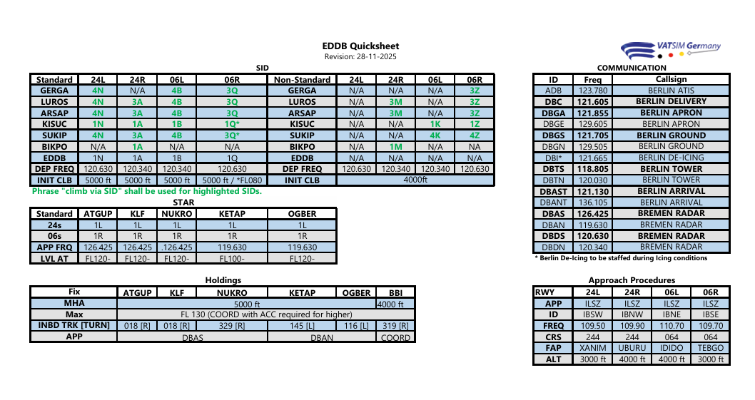](https://dms.vatsim-germany.org/s/dQ2TpD6CJQL2rra) # Delivery Berlin Delivery can be staffed as soon as there is Berlin Tower and Berlin Apron online. To open more than three stations on the ground Berlin Delivery is always required to be online. ### Runway Assignment The runway assignment is depending on the parking positions of departing aircraft. It might be necessary to deviate from this rule due to traffic. The task of Delivery is to assign the departure runways to the aircraft as efficient as possible at any time. *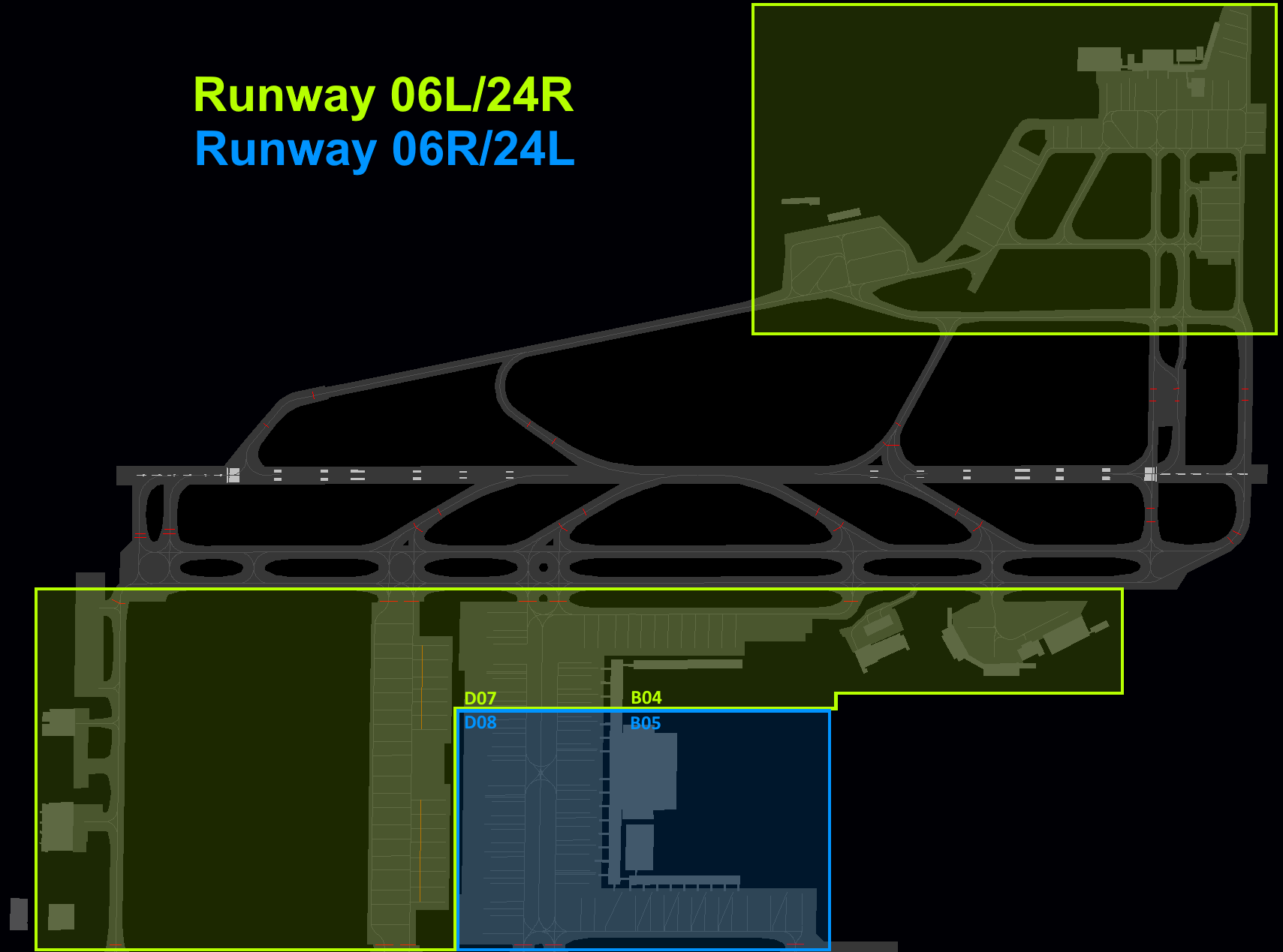* ### SIDs - **All SIDs are RNAV only** - All aircraft via SUKIP 3Q and KISUC 3Q are required to have an RFL (Requested Flight Level) of at least FL120 due to airspace structure #### BIKPO/GERGA SIDs With AIRAC 2511, GERGA SIDs are only available out of RWYs 06L, 06R and 24L. Traffic intending to depart from RWY 24R to the north is required to use the new shorter SID via BIKPO. With that, cases exist where Berlin Delivery needs to issue a re-clearance to the pilot:| Departure RWY | Filed Flight Plan via | Re-clearance via | Alias Command |
| 24R | First waypoint GERGA | BIKPO DCT GERGA flight-planned route | .rcbikpo |
| 06L, 06R, 24L | First waypoint BIKPO | GERGA M725 RENKI flight-planned route | .rcgerga |
The vSID will automatically choose the correct SID per runway, but will highlight any SID where a re-clearance is required (purple colour). In this case, Berlin Delivery shall issue the re-clearance and amend the flight plan accordingly.
### OIDs As all SIDs out of Berlin-Brandenburg are for RNAV-capable aircraft only, certain contingency procedures for non-RNAV aircraft need to be applied. For non-RNAV aircraft intending to depart IFR out of EDDB, so-called Omnidirectional Instrument Departures (OIDs) will be used instead. These OIDs will guide the departing aircraft on runway heading until reaching 2200 ft. Thereafter, the departing traffic will continue as cleared by ATC. Further information is available here: [https://knowledgebase.vatsim-germany.org/link/1167#bkmrk-omnidirectional-inst](https://knowledgebase.vatsim-germany.org/link/1167#bkmrk-omnidirectional-inst) The further clearance is subject to the clearance coordinated with Bremen Radar.**All EDDB OIDs shall be coordinated with Berlin Departure before IFR clearance is issued.**
Non-RNAV traffic is expected to file EDDB DCT TUVAK (RWYs 06) or EDDB DCT NISGA (RWYs 24) in the F-Plan and to inform ATC when requesting clearance. The initial climb for all OIDs is 5000 ft. ### Visual Departures Visual departures can be used for both runways, but only for propeller aeroplanes of up to two engines and the aircraft type DHC-7. Visual departures shall be coordinated with Bremen Radar individually. ### vSID Plugin Commands The following plugin commands for vSID are available at EDDB:| **Command** | **Explanation** |
| .vsid area eddb north | This will disable the area where all aircraft will be assigned to runway 06L/24R. |
| .vsid area eddb south | This will disable the area where all aircraft will be assigned to runway 06R/24L. |
**Within the Berlin Apron AoR, Low Visibility Procedures should be applied when visibility is below 300 m.** If deemed necessary, the responsible controller may also apply LVP during other meteorological conditions. Note: LVP does not need to be applied within the Apron AoR even if the rest of the airport (e.g. taxiways and runways) are using Low Visibility Procedures.
The following applies during Low Visibility Procedures (LVP): - Swing-over procedures shall be suspended, aircraft are allowed to push and taxi via the guidelines - **Crossing the virtual court via VC is not permitted** (Re-Routing via P1, P2 or T is mandatory)Berlin Apron shall inform Berlin Ground immediately when the crossing of the virtual court via VC is not possible anymore.
### Handoffs #### Handoffs during 06-Ops| **FROM** | **TO** | **HOLD SHORT OF** | **FROM POSITION** | **REMARK** |
| A\_GND | N\_GND | C | Main Apron | Prior release from E-GND required |
| A\_GND | S\_GND | B | Main Apron | -- |
| E\_GND | N\_GND | C | A/D-Apron | -- |
| E\_GND | N\_GND | C | E-Apron | -- |
| E\_GND | S\_GND | B | E-Apron | -- |
| E\_GND | N\_GND | K or K1 | Apron 2-3 | -- |
| **FROM** | **TO** | **HOLD SHORT OF** | **FROM POSITION** | **REMARK** |
| A\_GND | N\_GND | C | -- | Prior release from E-GND required |
| A\_GND | S\_GND | B | B/D-Apron | -- |
| A\_GND | S\_GND | B | C-Apron | -- |
| E\_GND | S\_GND | B | E-Apron | -- |
| A\_GND | N\_GND | K | Apron 2-3 | Via N1 preferred |
| E\_GND | N\_GND | C | A-Apron | -- |
| E\_GND | N\_GND | C | D01-D03 | -- |
| E\_GND | N\_GND | C | E-Apron | -- |
| E\_GND | N\_GND | K (via K5) | Apron 2-3 | -- |
| E\_GND | N\_GND | G (via K6) | Apron 2-3 | -- |
| **Taxiway** | **[ICAO Code Letter](https://knowledgebase.vatsim-germany.org/books/flugzeugkunde/page/icao-aerodrome-reference-code) and type of restriction** |
| **TWY E** | Code E |
| **TWY F** | Code E |
| **TWY P1, P2** | Code C on apron E between de-icing pad 03 and deicing pad 17 |
| Code E for aircraft de-icing on PAD03/PAD17 | |
| **TWY VC** | Code C between entry north and entry south with simultaneous taxiing traffic with Code C aircraft on the adjacent areas from V1, V2 and V3 |
| **Taxiways** | **[ICAO Code Letter](https://knowledgebase.vatsim-germany.org/books/flugzeugkunde/page/icao-aerodrome-reference-code) and type of restriction** |
| **TWY H** | Code C |
| **TWY K | Code D (max. wheel span 13 m) |
| Taxiing traffic TWY K -> TWY K4 for Code D aircraft only permitted from a westerly direction (max. B767-200) | |
| Taxiing traffic TWY K -> TWY K5 only for aircraft with wheelbase < 18m | |
| **TWY K4 | Code E |
| Taxiing traffic TWY K4 -> TWY K for Code D aircraft only permitted towards the west (max. B767-200) | |
| **TWY K5** (see exception for 34A/36A) | Code C Code D when using the De-Icing PAD NORTH |
| Taxiing from TWY K5 to TWY N3 is prohibited | |
| Taxiing traffic TWY K5 -> TWY K only for aircraft with wheelbase < 18m | |
| **TWY K6 north of TWY G** | Code C |
| **TXL N1 (apron 2)** | Code D |
| **TXL N1 (apron 2a, 3, 3a)** (see exception for 34A/36A) | Code C |
| **TXL N2 south of Pos. 50-54 | Code E |
| Code D when position 32 is occupied | |
| **TXL N2 south of Pos. 55-60** | Code E |
| **TWY N3** | Code C Code D when using the De-Icing PAD NORTH |
**Note:** TWYs N1 and K5 are only approved for aircraft up to Code letter C. In real-life this restriction can be disregared when using a Follow-Me car. As we don't have any option to simulate this, we apply the exception that N1/K5 can be used by aircraft up to Code E, but only when intending to use parking stands 34A or 36A.
When the RVR falls below 1000 m and/or the ceiling is at or below 300 ft and CAT II/III operations are expected, Berlin Tower will inform Berlin Ground to issue taxi instructions to the CAT II/III holding point only.
#### Handoff from Tower - - Aircraft will switch to Ground automatically once vacated - Information to the pilots via the ATIS mandatory - Support pilots who are not switching to Ground automatically ### Handoffs #### Handoffs during 06-Ops| **FROM** | **TO** | **HOLD SHORT OF** | **TO POSITION** | **REMARK** |
| S\_GND | A-GND | V1 | Main Apron | -- |
| S\_GND | A\_GND | Apron / E | Main Apron | When vacated via M7 |
| S\_GND | E\_GND | P1 | A/E-Apron | -- |
| S\_GND | E\_GND | B | A/E-Apron | When vacated via M6 |
| N\_GND | A\_GND | V4 | Main Apron | -- |
| N\_GND | E\_GND | L5 | Apron A | -- |
| N\_GND | E\_GND | C | Apron A | When vacated via L5 |
| N\_GND | E\_GND | V4 | D01-D03 | -- |
| N\_GND | E\_GND | P2 | E-Apron | -- |
| N\_GND | E\_GND | K | Apron 2-3 | -- |
| N\_GND | E\_GND | K6 (via G) | Apron 2-3 | -- |
| N\_GND | E\_GND | G (via K6) | Apron 2-3 | -- |
| S\_GND | N\_GND | C (via T) | -- | -- |
| **FROM** | **TO** | **HOLD SHORT OF** | **TO POSITION** | **REMARK** |
| S\_GND | A\_GND | V1 | Main Apron | -- |
| S\_GND | E\_GND | P1 | E-Apron | -- |
| N\_GND | A\_GND | Apron / F | Main Apron | When vacated via L4 |
| N\_GND | A\_GND | V3 | Main Apron | -- |
| N\_GND | E\_GND | Apron / F | D01-D03, A-Apron | When vacated via L4 |
| N\_GND | A\_GND | V3 | D01-D03, A-Apron | -- |
| N\_GND | E\_GND | C | E-Apron | When vacated via L3 |
| N\_GND | E\_GND | K | Apron 2-3 | -- |
| S\_GND | N\_GND | C (via T) | D01-D03, Apron A | -- |
| **Taxiway** | **[ICAO Code Letter](https://knowledgebase.vatsim-germany.org/books/flugzeugkunde/page/icao-aerodrome-reference-code) and type of restriction** |
| **TWY L6 south of C** | Code C |
| **TWY P1, P2 | Code D between TWY M6 and apron E with simultaneous taxi movements in the intersection area with TWY A/B |
| Code D between TWY L3 and apron E with simultaneous taxi movements in the intersection area with TWY C/D | |
| Code C on apron E between de-icing pad 03 and deicing pad 17 | |
| Code E for aircraft de-icing on PAD03/PAD17 | |
| **TWY Y1 | Code A |
| Helicopters with a max. rotor diameter of 10.70 m | |
| **Apron 1** | No civil use (military security area) |
| **Apron 4** | Code C |
| **Taxiway** | **[ICAO Code Letter](https://knowledgebase.vatsim-germany.org/books/flugzeugkunde/page/icao-aerodrome-reference-code) and type of restriction** |
| **TWY G | Code E |
| Taxiing traffic with Code D and E towards TWY K4 only permitted from west to south | |
| Taxiing traffic G -> K4 to the north permitted for the following Code D aircraft: E-3 AWACS, A400M, C-130 Hercules, C-160 Transall, P8A-Poseidon | |
| **TWY K1 west of apron 1 | Code F up to 68.4m wingspan |
| Max. landing gear width 13m | |
| **TWY K1 east if apron 1** | Code E |
| **TWY K2** | Code C |
| **TWY K3** | Code D |
| **TWY K4 | Code E |
| Entry onto RWY 06L/24R only up to Code D | |
| Exit from RWY 06L/24R to TWY K4 only up to Code D | |
| Taxiing traffic with Code D and E towards TWY G only permitted from the south to the west | |
| Taxiing traffic K4 -> G from the north permitted for the following Code D aircraft: E-3 AWACS, A400M, C-130 Hercules, C-160 Transall, P8A-Poseidon | |
| **TWY K5** | Code C |
| **TWY K6 south of G** | Code E |
| **Station** | **Station ID** | **Frequency** | **Login** |
| Berlin Tower Nord | DBTN | 120.030 | EDDB\_N\_TWR |
| Berlin Tower Süd | DBTS | 118.805 | EDDB\_S\_TWR |
If both Tower are online, the CTR is divided into two AoRs with a border between the runways. In case Ground is offline, Tower will cover this station (DBTN will cover DBGN and EDTS will cover DBGS).
## General ### Modes of operation Berlin Airport is authorized for the following modes of operations:| **Mode** | **Spacing between 06L/24R and 06R/24L** |
| Staggered Approaches | 3 NM |
| Independent Parallel Approaches | --- |
| Independent Parallel Departures | --- |
| Dedicated Runway Operations (DROps) | --- |
Staggered Approaches is the standard mode of operation. Independent Parallel Approaches will only be used whe required due to traffic.** Parallel Operations (approaches and departures) cannot be performed with an aircraft on the ILS X.**
#### Independent Parallel Approaches During periods of high traffic, independent parallel approaches may be used.**Parallel Operations (approaches and departures) cannot be performed with an aircraft on the ILS X.**
**SUSPENSION OF INDEPENDENT PARALLEL OPERATIONS DUE TO METEOROLOGICAL CONDITIONS:** The meteorological conditions to be considered include, but are not limited to, the following: 1. wind shear; 2. turbulence; 3. downdrafts; and 4. crosswind and significant meteorological conditions such as thunderstorms, which might otherwise increase deviations from the final approach course or track to the extent that safety may be impaired.When the RVR falls below 1000 m and/or the ceiling is at or below 300 ft and CAT II/III operations are expected, Berlin Tower should use DROps and inform Berlin Ground about the beginning of the LVP preparation phase.
#### Segmented Approaches (ILS/RNP Y) and ILS X Bremen Radar shall inform Berlin Tower about the use of segmented approaches (ILS/RNP Y), which will be used during times of low traffic. Bremen Radar will also inform Berlin Tower about aircraft using the ILS X.**The ILS/RNP Y requires a diagonal separation of 3 NM.** Dependent parallel or alternating approaches are not allowed. **Behind every aircraft flying the ILS X, a minimum separation of 15 NM is required on both runways.**
The standard approach type is ILS Z. The RNP Z will be used whenever the ILS is not available or when requested by the pilot. ### Target Spacing The responsible approach controllers will use the following target spacings depending on the conditions:| **Conditions** | **Target Spacing** |
| Departures expected | 6 NM |
| No departures expected | 3 NM |
| Low Visibility Operations | 5 NM |
Note: Tower may ask the approach control to increase the target spacing in case traffic has to depart between approaching aircraft. Usually, the Berlin approach unit will take the situation of departing traffic on the ground into account.
As long as possible, Tower may use reduced runway separation to depart traffic between approaching traffic. Due to the mixed operations on both runways, Berlin Tower must use every gap sufficient for departing traffic.
### Landing Clearance Line (LCL) Due to mixed operations on both runways at EDDB, a landing clearance line is established 90 m from the runway's centerline to expedite landing and takeoff clearances. As soon as a landing aircraft has crossed the landing clearance line, a takeoff or landing clearance can be issued to any succeeding aircraft. The landing clearance line can be used whenever the following conditions are met: - The landing clearance line is visible on the ground radar display - The braking action on the runway is not reduced significantly - For Vatsim only SN, ST, PL, GR and GS are considered as a reduction of braking action - The vacating aircraft does not exceed ICAO Code Letter E - The vacating traffic does not stop until reaching the holding point [](https://knowledgebase.vatsim-germany.org/uploads/images/gallery/2024-07/euroscope-2bhyfiqkxg.png) ### Reduced Runway Separation (RRS) Berlin-Brandenburg Airport (EDDB) is approved to apply the following reduced runway separation minima during day and night:| **Runway** | CAT 1 following a departing CAT 1 or 2 | CAT 2 following a departing CAT 1 or 2 | CAT 1 to 3 following a departing CAT 3 |
| RWY 06L/24R | 600 m | 1500 m | 2400 m |
| RWY 06R/24L | 600 m | 1500 m | 2400 m |
| **Conditions** | **Separation** |
| Same SID following | 3 NM\* |
| Different SID following | 3 NM |
| **Station** | **Station ID** | **Frequency** | **Login** |
| Berlin Departure Nord | DBDN | 120.340 | EDDB\_N\_DEP |
| Berlin Departure Süd | DBDS | 120.630 | EDDB\_S\_DEP |
Both frequencies shall be cross-coupled by the responsible controller.
### ARSAP Overflow Area The ARSAP Overflow Area may be activated on request by EDWW sector FLG during periods of high traffic. This will raise the vertical limit of sectors DBDN/DBDS east of EDDB from FL165 to FL235 to transfer departures from EDDB via ARSAP to EPWW sector D directly.During the activity of the ARSAP Overflow Area, full ATS is delegated from FLG to DBDN/DBDS within this area.
[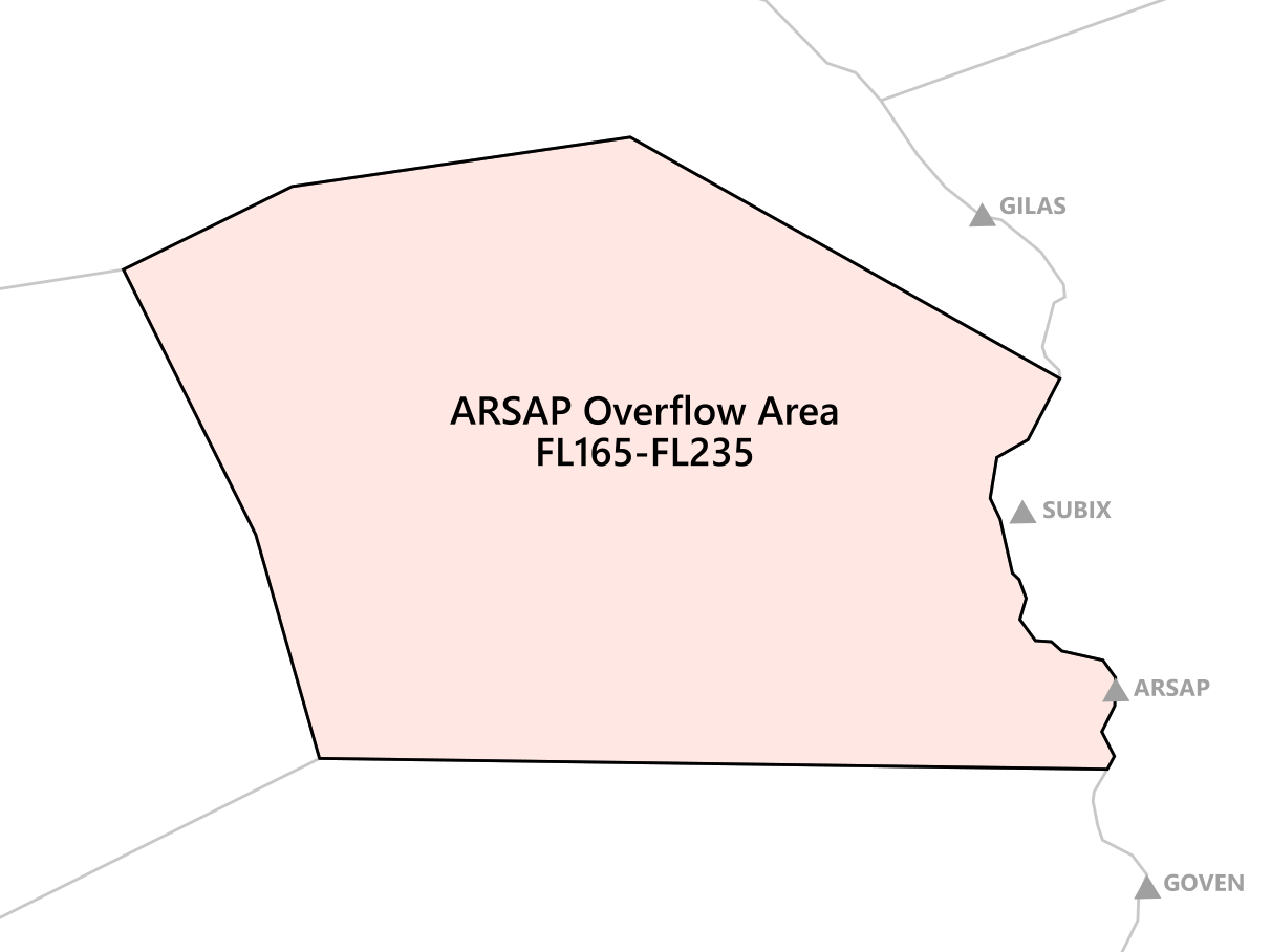](https://knowledgebase.vatsim-germany.org/uploads/images/gallery/2024-07/inkscape-xiuq8euvnd.png)Due to Euroscope limitations, sectors DBDN and DBDS shall select any runway for EDAE in the active runway dialogue to activate the ARSAP Overflow Area. In addition, sectors BOR, FLG and MAR shall also select a runway at EDAE to generate correct sector predictions. This is the only way to delegate this airspace from sector FLG to sectors DBDN/DBDS.
Sector DBDS is responsible for transferring aircraft via ARSAP to EPWW sector D according to the LoA between EDWW and EPWW:| **Aerodromes** | **COP** | **Level** | **Special Conditions** | **To Sector** |
| Outbound from EDDB | ARSAP | ↑FL170-FL230 | Odd levels below FL230 will only be used when required for separation purposes. DBDS may transfer departures EDDB on top of each other. | EPWW-D |
| Inbound to EPPO, EPZG | ARSAP | FL210 | --- | EPWW-D |
Traffic on L and M SIDs is generally approved to cross ED-R 146 in case of a low climb rate or an RFL of 5000 ft or below.
## Departing Traffic from EDDB ### Modes of Operation #### Independent Parallel Departures Independent parallel departures shall always be used, except if the following requirements are not met:**Parallel Operations (approaches and departures) cannot be performed with an aircraft on the ILS X.**
**SUSPENSION OF INDEPENDENT PARALLEL OPERATIONS DUE TO METEOROLOGICAL CONDITIONS:** The meteorological conditions to be considered include, but are not limited to, the following: 1. wind shear; 2. turbulence; 3. downdrafts; and 4. crosswind and significant meteorological conditions such as thunderstorms, which might otherwise increase deviations from the final approach course or track to the extent that safety may be impaired.Use the LoA for details on level agreements: [https://atciss.vatsim-germany.org/static/loa/LOP\_EDWW.pdf](https://atciss.vatsim-germany.org/static/loa/LOP_EDWW.pdf)
Departures EDDB on SUKIP SIDs shall be transferred depending on the following airway: - SUKIP Y206 BUREL shall be transferred to sector BOR - SUKIP M748 SOGMA shall be transferred to sector MAR
### Departure-Split During a departure split, both sectors are not allowed to give instructions to aircraft to cross the other's sector. Coordination is always necessary!Check the LoA for the handoff level between DBDN and DBDS: [https://knowledgebase.vatsim-germany.org/books/bremen-fir-edww/page/bremen-acc-internal](https://knowledgebase.vatsim-germany.org/books/bremen-fir-edww/page/bremen-acc-internal)
### Tactical Directs| **Tactical Direct** | **Special Conditions** | **From Sector** | **To Sector** |
| HLZ | Only during 24-Ops | DBDN | BOR |
| BUREL | Only during 06-Ops | ||
| POVEL | - | ||
| PODER | Only with Destination EDDK and RFL above FL245 | ||
| DENOL | Only with Destination EDDL/EDLV and RFL above FL245 | ||
| APEBE | |||
| MAG | - | DBDS | |
| ODLUN | - | ||
| MAXAN | - | ||
| ARSAP | - | FLG |
| **Conditions** | **EDDB RWYs 06** | **EDDB RWYs 24** |
| IFR clearance | DBDN | DBAN |
| Approach clearance | DBAN | DBAN |
| Approach monitoring | DBDN | DBAN |
| **Runway** | **Available Approach Types** | **IAF** | **Altitude at IAF** |
| 05/23 | RNP | RENKI | 4000 ft |
Coordination is required with the station responsible for the approach monitoring prior to the approach clearance from DBAN. Airacft will be transferred to this monitoring station when on the published procedure.
## Schönhagen (EDAZ) Schönhagen (EDAZ) is an uncontrolled aerodrome located about 15 NM southwest of EDDB. Due to published IFR procedures limited service has to be provided for IFR traffic: - Approach clearance and approach monitoring - IFR clearance ### Responsible stations| **Conditions** | **EDDB RWYs 06** | **EDDB RWYs 24** |
| IFR clearance | DBAST | DBDS |
| Approach clearance | DBAS | DBAS |
| Approach monitoring | DBAST | DBDS |
| **Runway** | **Available Approach Types** | **IAF** | **Altitude at IAF** |
| 25 | RNP | MOSEX | 3000 ft or 4000 ft, depending on MVA |
| 07 | Only RNP 25 followed by circling runway 07 is available. | ||
Due to the crossing of EDDB D(CTR), Berlin Tower shall be informed about every approach on runway 25 at EDAZ.
Coordination is required with the station responsible for the approach monitoring prior to the approach clearance from DBAS. Airacft will be transferred to this monitoring station when on the published procedure.
The station responsible for the approach monitoring shall inform Berlin Tower about the IFR arrival at EDAZ once this traffic joins the approach procedure and once this traffic has landed.
Approaches EDDB runway 24L and IFR approaches EDAZ will be generally considered independent.
# Arrival ## Sectorization and Airspace ### Sector Berlin Arrival ### [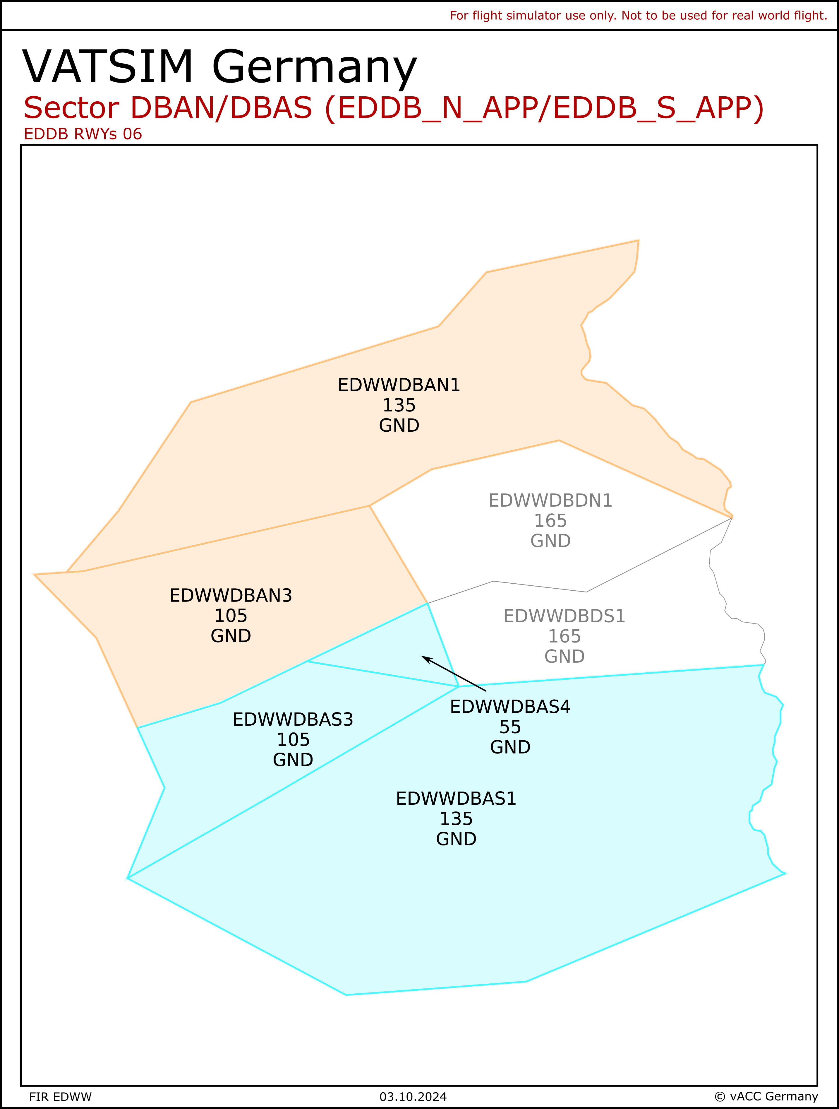](https://knowledgebase.vatsim-germany.org/uploads/images/gallery/2024-08/dba-06.png)[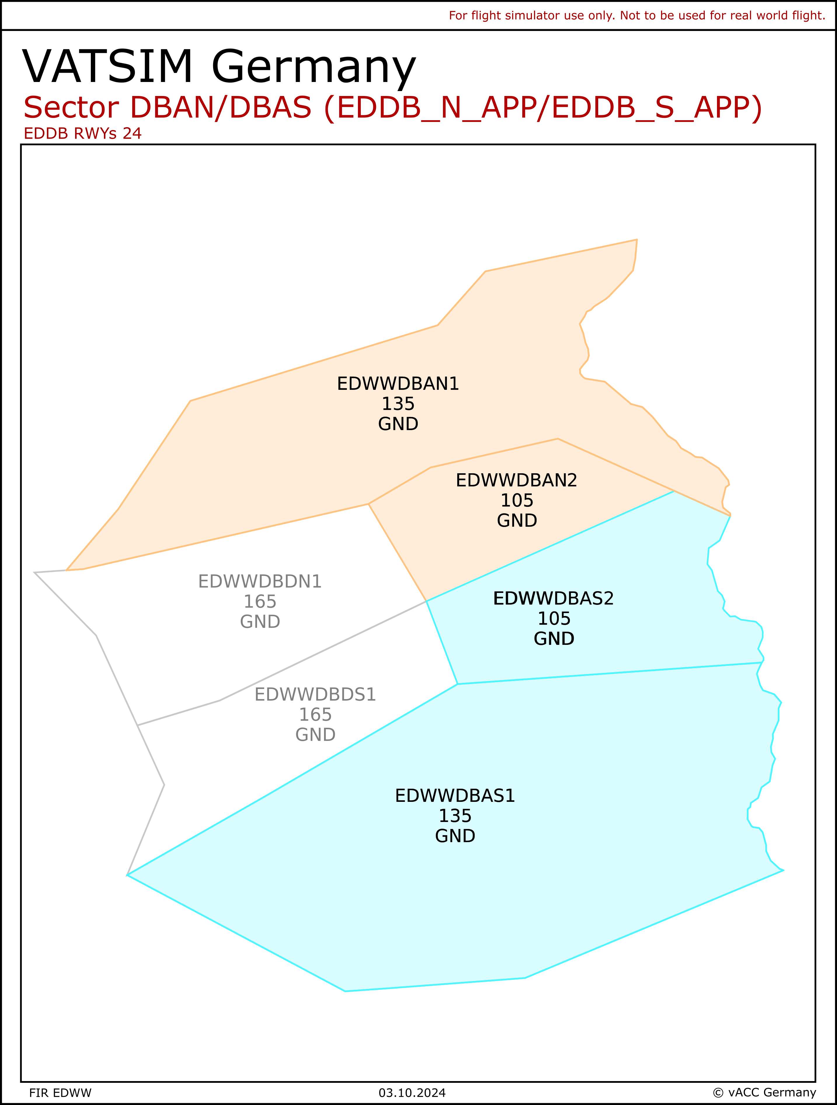](https://knowledgebase.vatsim-germany.org/uploads/images/gallery/2024-08/dba-24.png)| **Station** | **Station ID** | **Frequency** | **Login** |
| **Pickup** | |||
| Bremen Radar (Pickup Nord) | DBAN | 119.630 | EDDB\_N\_APP |
| Bremen Radar (Pickup Süd) | DBAS | 126.425 | EDDB\_S\_APP |
| **Feeder** | |||
| Berlin Arrival (Feeder Nord) | DBANT | 136.105 | EDDB\_AN\_APP |
| Berlin Arrival (Feeder Süd) | DBAST | 121.130 | EDDB\_AS\_APP |
| **Coordinator** | |||
| Berlin Coordinator | --- | --- | Any middle locator which has higher priority than DBAN or DBAS |
Note: EDDB\_N\_APP may be staffed without the requirement of Departure to be online. In this case, EDDB\_S\_APP take over all responsibilities for DBDN and DBDS. To staff the DBAN-DBAS split, a Feeder must be online first.
All frequencies (incl. Berlin Departure) shall be cross-coupled by the responsible controller.
A second Feeder will only be staffed when Independent Parallel Approach operations are required.
The Coordinator position will take over all pre-planning responsibilities for the Pickup station. The main task is to coordinate all arrivals so that an initial sequence is created for the Pickup. The coordinator works on all coordination duties. Tags from the CTR station will always be transferred to the executive controller immediately. The Berlin Coordinator shall log in with a callsign having a higher priority than DBAN/DBAS (e.g. EDDB\_C\_APP) and the correct primary frequency selected.
### Holzdorf AoR Holzdorf AoR (ETSH\_APP) may be staffed. This will delegate the airspace described below from GND to 5500 ft. Every movement between ETSH\_APP and Bremen Radar requires prior coordination. Bremen Radar sector DBAS will perform top-down service when ETSH is offline (Bremen Radar will not provide SRA and PAR approaches). [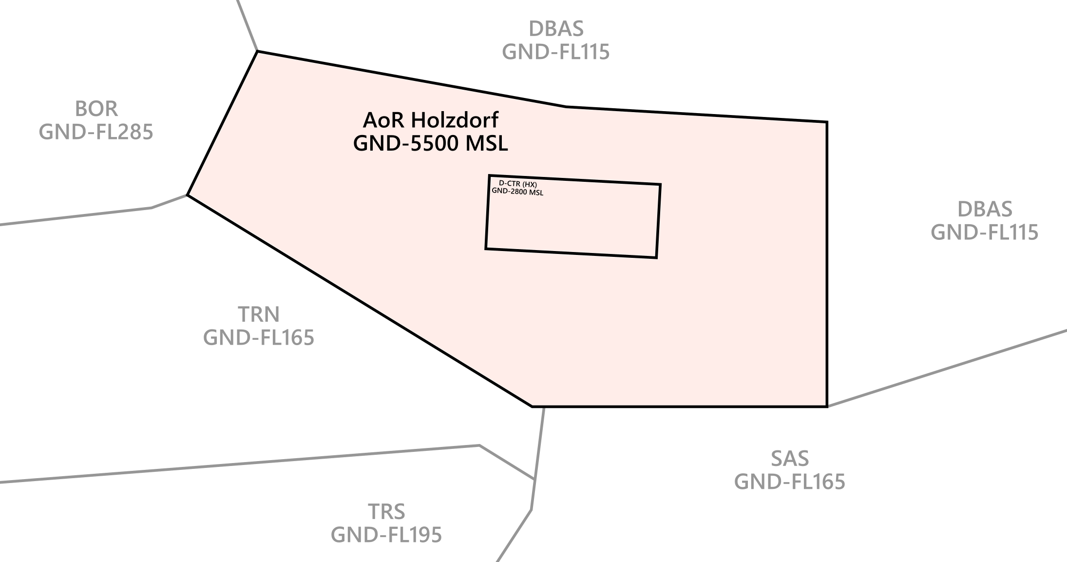](https://knowledgebase.vatsim-germany.org/uploads/images/gallery/2022-10/holzdorf-aor.png) ### TORGAU Area EDMM sector TRN may request the activation of TORGAU Area during RWYs 26 at EDDP. See [LoA EDWW-EDMM](https://knowledgebase.vatsim-germany.org/books/bremen-fir-edww/page/bremen-acc-munchen-acc) para 2.4.2. [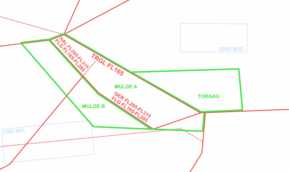](https://knowledgebase.vatsim-germany.org/uploads/images/gallery/2022-09/mulde-torgau-area.png) ### Airspace All active ED-Rs displayed on the radar screen shall be simulated. ED-R4 and ED-R146 will be active 24/7. Inbound traffic to EDDB shall always stay inside airspace class C. Level-offs might be necessary during descent to keep traffic inside protected airspace. ## Arriving traffic to EDDB ### Runway Allocation The pilot shall be informed about the expected runway on initial contact with DBAN/DBAS. In almost all circumstances, runways are assigned depending on the planned parking position to reduce taxi times:  Depending on the traffic situation, DBAN/DBAS may deviate from this RWY distribution when required for load balancing. ### Managing inbound traffic In general, STARs will be cleared by APP only when necessary. Traffic will mostly be vectored to the final. Often, an initial direct to a waypoint on the STAR can guide the traffic efficiently. The full STARs are rarely used and are only designed as frequency relief procedures for Pickup.Pickup shall make use of early coordination with ACC sectors MAR and FLG as well as with EPWW, in order to sequence traffic from the various clearance limits. Early coordinated headings, speeds and holdings will ensure a good traffic flow. Mostly, ACC sectors MAR and FLG explicitly wait for coordination with DBAN/DBAS before the transfer of communications is executed.
As traffic often is shortly prior to reaching the IAF/clearance limit (KETAP, OGBER, NUKRO, ATGUP, KLF), a further clearance on the initial call is recommended in order to avoid unwanted holdings.
Any approved/requested DCT for arrivals **EDDB**, given by DBAN/DBAS to MAR/FLG, shall include the approval to cross the airspace of sectors DBDN/DBDS!
### Holdings Published holdings are available at the IAFs/clearance limits. Holdings at KETAP and OGBER shall always be coordinated with ACC sector MAR. Holdings at NUKRO and ATGUP/KLF shall always be coordinated with ACC sector FLG. - The Holdings at KLF and ATGUP are dependent. The traffic of both clearance limits will usually be managed inside one holding. - Further information about holding procedures shall be found in the [EDWW LoA](https://dms.vatsim-germany.org/s/a5DNLX7QfDq5fbj) para 4.1.4 ### Approach Types There are 4 published approach types available at EDDB. By default, the ILS approach will be used.| **Runway** | **Available Approach Types** | **Intercept Altitude** |
| 06L/24R | ILS Z, ILS Y, ILS X, LOC, RNP Z, RNP Y | 4000 ft |
| 06R/24L | 3000 ft |
The ILS/RNP Y should only be cleared via the IAFs published for the approach.
#### ILS X Bremen Radar shall inform Berlin Tower about the use of the ILS X. Due to the nature of the missed approach procedure, Bremen Radar shall apply a minimum separation of 15 NM behind every aircraft performing the ILS X approach. This separation shall also apply to aircraft on the parallel runway. ### Modes of Operation Berlin Airport is authorized for the following modes of operations:| **Mode** | **Spacing between 06L/24R and 06R/24L** |
| Staggered Approaches | 3 NM |
| Independent Parallel Approaches | --- |
| Dedicated Runway Operations (DROps) | --- |
Staggered approaches is the standard mode of operation. Independent parallel approaches will only be used when required due to traffic.
**Behind every aircraft flying the ILS X, a minimum separation of 15 NM is required on both runways.**
#### Independent Parallel Approaches During periods of high traffic, independent parallel approaches may be used.| **Conditions** | **Target Spacing** |
| Departures expected | 6 NM |
| No departures expected | 3 NM |
| Low Visibility Operations | 5 NM |
The approach shall assess the situation on the ground regarding departing traffic and shall adjust the target spacing accordingly. No coordination is required in order to reduce to 3 NM in case no departing traffic is expected between approaching aircraft.
Note: Berlin Tower may reduce aircraft on final inside the EDDB D(CTR) without any prior notification.
### Handoff Pickup to Feeder DBAN/DBAS shall guide arrivals to EDDB in such a way that an interim arrival sequence is reached prior to transferring the aircraft.| **TO** | **ALTITUDE** | **CONDITIONS** |
| DBANT/DBAST | 5000 ft | Dependent Parallel Ops |
| DBANT | 6000 ft | Independent Parallel Ops |
| DBAST | 4000 ft | Independent Parallel Ops |
| **Procedure** | **Description** |
| FL70 between OGBER/KETAP | Arrivals to EDDB shall not be cleared to descend below FL70 before passing a position abeam EDDB if guided north of the aerodrome but south of the direct line between OGBER and KETAP |
| 13 NM final runways 06L/R from 22:00 lcl - 06:00 lcl | Vectored approaches to RWYs 06L/R shall be guided in a way that the aircraft is established on the final approach track 13 NM from the touchdown between 22:00 local time and 06:00 local time. Aircraft in an emergency or distress situation or an urgent exceptional situation (e.g. meteorological reasons) as well as visual approaches shall be exempted from this provision. |
| Visual Approach RWYs 06/24 | Whenever issuing a clearance for a visual approach the pilot shall be instructed to conduct the approach in such a way that the final approach is not less than 6 NM and descent below 2000 ft MSL will not be performed prior to reaching final approach. |
| **Conditions** | **EDDB RWYs 06** | **EDDB RWYs 24** |
| IFR clearance | DBDN | DBAN |
| Approach clearance | DBAN | DBAN |
| Approach monitoring | DBDN | DBAN |
| **Runway** | **Available Approach Types** | **IAF** | **Altitude at IAF** |
| 05/23 | RNP | RENKI | 4000 ft |
Coordination is required with the station responsible for the approach monitoring prior to the approach clearance from DBAN. Airacft will be transferred to this monitoring station when on the published procedure.
## Schönhagen (EDAZ) Schönhagen (EDAZ) is an uncontrolled aerodrome located about 15 NM southwest of EDDB. Due to published IFR procedures limited service has to be provided for IFR traffic: - Approach clearance and approach monitoring - IFR clearance ### Responsible stations| **Conditions** | **EDDB RWYs 06** | **EDDB RWYs 24** |
| IFR clearance | DBAST | DBDS |
| Approach clearance | DBAS | DBAS |
| Approach monitoring | DBAST | DBDS |
| **Runway** | **Available Approach Types** | **IAF** | **Altitude at IAF** |
| 25 | RNP | MOSEX | 3000 ft or 4000 ft, depending on MVA |
| 07 | Only RNP 25 followed by circling runway 07 is available. | ||
Due to the crossing of EDDB D(CTR), Berlin Tower shall be informed about every approach on runway 25 at EDAZ.
Coordination is required with the station responsible for the approach monitoring prior to the approach clearance from DBAS. Airacft will be transferred to this monitoring station when on the published procedure.
The station responsible for the approach monitoring shall inform Berlin Tower about the IFR arrival at EDAZ once this traffic joins the approach procedure and once this traffic has landed.
Approaches EDDB runway 24L and IFR approaches EDAZ will be generally considered independent.
# Independent Approach Operations (BER) ### Introduction and a word on efficiency During high traffic operations in Berlin, independent parallel approach operations may be used. The following guide shall give a deeper look into the rules, requirements, best practices and general operations. Since dependent parallel approaches (1.5 NM diagonal separation) are not allowed at EDDB, the use of independent parallel approaches can become necessary during traffic peaks. Besides the requirements listed further down below, **it does not make sense** to switch to independent approach operations when… - …there is not enough traffic to fill up the finals. In these cases, normal intercepts via 10 NM final are much more efficient. - …the pickup controllers do not have enough capacity (high workload) to fill up the downwinds with enough traffic for independent operations to turn out efficiently. ### Requirements (EASA)In Berlin, only the **ILS Z and RNP Z** can be used for parallel independent approach operations. The RNP Z can only be used under LNAV/VNAV or LPV modes.
### Handoff to Arrival (Feeder) During Independent Approach operations, the aircraft shall be transferred from Pickup to Feeder as follows: - RWY 06L/24R: at 6000 ft to DBANT (on EDDB QNH) - RWY 06R/24L: at 4000 ft to DBAST (on EDDB QNH) ### Two-Feeder Operations Independent Approach operations may be performed by using two Feeder positions. The responsibilities are defined as follows: - DBANT = EDDB\_AN\_APP (136.105): responsible for 06L/24R - DBAST = EDDB\_AS\_APP (121.130): responsible for 06R/24LDuring Two-Feeder operations, runway **06L/24R shall only intercept at a minimum of 5000 ft** or higher. Aircraft for runway **06R/24L shall only intercept at 3000 ft or 4000 ft**. Strict adherence to the turning areas is required! (see below)
### Turning Areas The turning area is available as a Topsky map and helps to reduce the complexity and coordination between the two Feeders. The turning area will show the point where aircraft for a specific runway are allowed to intercept the localizer. During Independent Approach operations, aircraft must fly **2 NM levelled while established on the final track** before intercepting the glide path. High final: For runway 24R/06L, the rule above means aircraft intercepting at 4000 ft must therefore intercept the final at ~14 NM or longer. When intercepting at 5000 ft, the aircraft must intercept the final at ~17 NM or longer. Low final: Since aircraft intercepting 24L/06R need to stay separated with at least 3 NM/1000 ft until established on final track, their latest turn-on point for an intercept at 3000 ft needs to be 3NM away from the point where aircraft on the high final leave 4000 ft on the glidepath (~12 NM final). The same applies when intercepting 4000 ft on 24L/06R, where aircraft need to be 3 NM away from the point where the aircraft on the high final would leave 5000 ft on the glidepath (~15 NM final). [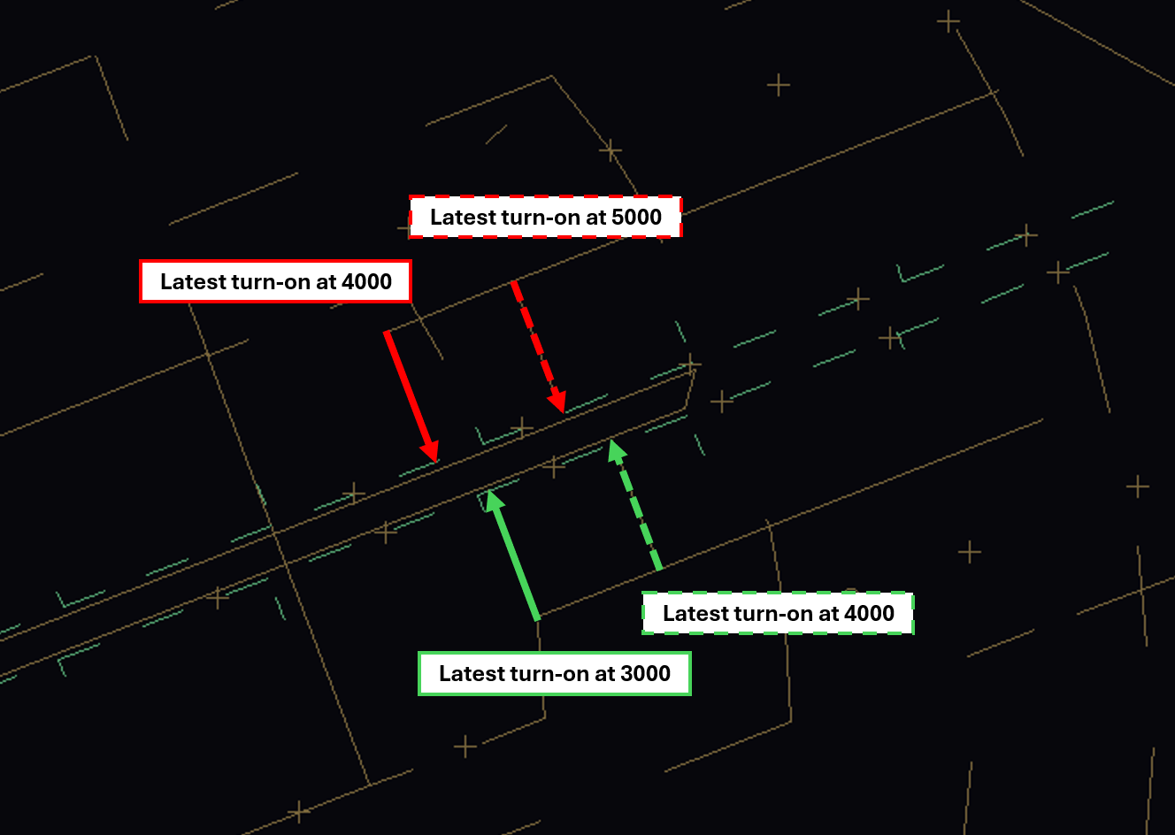](https://knowledgebase.vatsim-germany.org/uploads/images/gallery/2025-10/Mrcimage.png) Final turns: **Intercept angles for the final track must not exceed 30 degrees!** [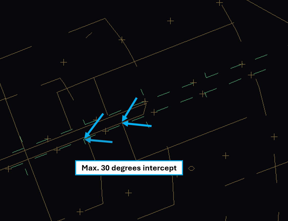](https://knowledgebase.vatsim-germany.org/uploads/images/gallery/2025-10/TCEimage.png) Base turns: The Feeder responsible for the low final (south) shall not clear aircraft towards the final until they have vacated the intercept level of the high final (north). That means aircraft planned for 24L/06R **must** be at 3000 ft (when 4000 ft is used for the high final) or 4000 ft (when 5000 ft is used for the high final) inside the IPA turning boxes (see image below).**Never** turn an aircraft on base leg for the south final unless they have established 1000 ft separation to the north final!
[](https://knowledgebase.vatsim-germany.org/uploads/images/gallery/2025-10/hkjimage.png) ### MVA and Airspace [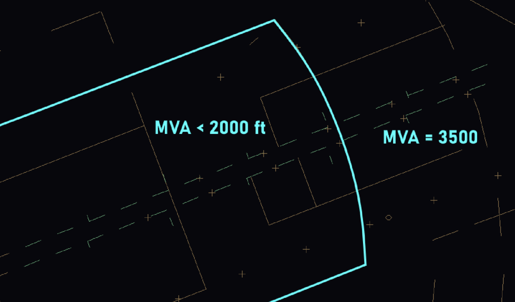 ](https://knowledgebase.vatsim-germany.org/uploads/images/gallery/2025-10/Hd7image.png)[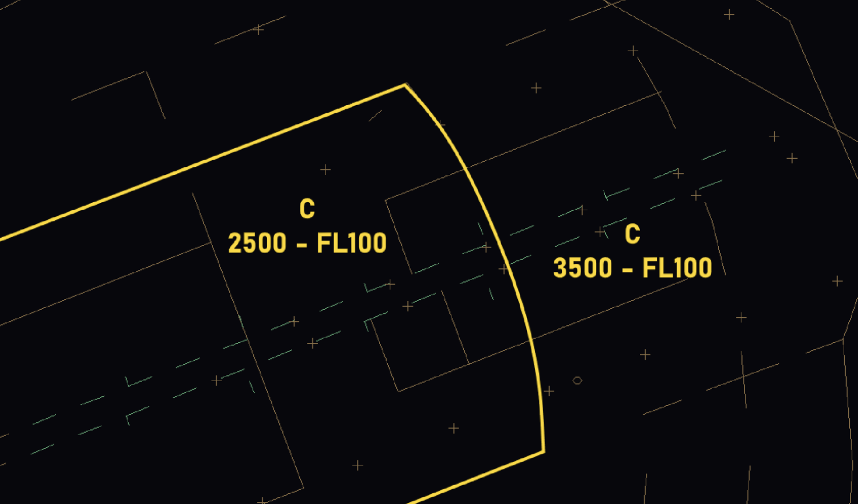](https://knowledgebase.vatsim-germany.org/uploads/images/gallery/2025-10/Aqjimage.png) **Always pay close attention to the MVA and airspace structure when working south feeder!** It may not be possible to turn aircraft base before they reach the limits of the lowered MVA and airspace class C. In these cases, hold aircraft at 4000 ft and let them intercept within the respective turn-on area. South feeder should always plan ahead and evaluate whether a base turn before reaching the 3500 ft MVA is possible or not. If that is the case, aircraft should be cleared to 3000 ft on initial contact to get the aircraft low enough as early as possible. ### Non-Transgression Zone (NTZ) - Width 610 m - This leaves 645 m normal operation zone on either sideIf an aircraft deviates from the localizer and enters the NTZ, separation must be achieved immediately by turning out **the other** aircraft from the localizer.
Phraseology: **TURN LEFT** (or RIGHT) (number) **DEGREES** (or HEADING) three digits) IMMEDIATELY TO AVOID TRAFFIC \[DEVIATING FROM ADJACENT APPROACH\], **CLIMB TO** (altitude) ### Transfer to Tower Transfer to Tower frequencies will take place when established on the localizer at about 14 NM from Touchdown.Tower controllers and Approach controllers shall monitor the approach at any time!
### Perspective of the Pickup-Controller #### Runway allocation Both Pickups will assign the runway as soon as possible. By default, the runway should be assigned according to the standard runway assignment described in the SOP. Nevertheless, it is the responsibility of both Pickup controllers to observe the current load balance. If required, traffic parking on stands A, B, C, D or E may be shifted to the other runway. This should be coordinated between both Pickups. During very high traffic, both Pickups may agree to segregate arrivals (KETAP/OGBER RWY 06L/24R, KLF/ATGUP/NUKRO RWY 06R/24L). This will reduce the complexity in the TMA but deviates from real-life procedures. When using this procedure, traffic parking north of RWY 06L/24R should always be assigned RWY 06L/24R to reduce taxi times and to avoid the runway crossing. #### Handoffs to Arrival (Feeder) Aircraft approaching two different runways do not have to be sequenced to have a minimum spacing in between them, as it is recommended during normal operations. You can always hand them off on top of each other; they will be handled independently, after all. ### Switching to Independent Approach Operations Only after coordination with DBANT/DBAST, the mode of operation is changed: 1. DBAS shall notify DBAN and Berlin Tower about the mode of operation change. 2. DBANT/DBAST shall activate the turning area (Areas folder in TopSky Maps) 3. [ATIS](https://knowledgebase.vatsim-germany.org/link/922#bkmrk-code-broadcast-%26lvp-) shall be changed to display "PARALLEL INDEPENDENT OPERATIONS IN PROGRESS" 4. All aircraft already in the arrival sectors (DBAN, DBAS, DBANT or DBAST) shall be notified about the mode of operation change. # ATIS Codes ### Default ATISmaker URL > https://www.uniatis.net/atis.php?&metar=$metar($atisairport)&arr=$arrrwy($atisairport)&dep=$deprwy($atisairport)&apptype=ILS&info=$atiscode **In Berlin, the departure frequency shall not be displayed in the ATIS!** ### Optional ATIS Codes **Note: Taxi in () are notes only and will not be displayed in the ATIS.**| **CODE** | **Broadcast** |
| **&lvp** | \[LOW VISIBILITY PROCEDURES IN OPERATION CAT II AND III AVAILABLE\] |
| **&indep** | \[EXPECT\]\[INDEPENDENT PARALLEL ILS APPROACH\]\[RUNWAY\] X \[AND\] Y \[ \] *(X,Y runway will be selected automatically)* |
| **&gndf=xxx.xxx** | \[AFTER VACATING RUNWAY\] %actrwy\_or% \[CONTACT GROUND ON FREQUENCY\]\[ \]xxx.xxx\[ \] *(xxx.xxx change with active frequency)* |
| **&nognd** | \[AFTER VACATING RUNWAY\] %actrwy\_or% \[REMAIN ON FREQUENCY\]\[ \] *(%actrwy\_or% runway will be selected automatically)* |
| **&gnds** | \[AFTER VACATING RUNWAY\]\[ \]%actrwy\_or%\[ \]\[CONTACT GROUND ON FREQUENCY\]\[ \]\[121.705\]\[ \]*(%actrwy\_or% runways will be selected automatically)* |
| **&gndboth** | \[AFTER VACATING RUNWAY\]\[ \]%gndbothrwyone%\[ \]\[CONTACT GROUND ON FREQUENCY\]\[ \]129.505\[ \]\[AFTER VATING RUNWAY\]\[ \]%gndbothrwytwo%\[ \]\[CONTACT GROUND ON FREQUENCY\]\[ \]121.705\[ \]*(%gndbothrwyone%,%gndbothrwytwo% runways will be selected automatically)* |
| **&drops** | \[ALL DEPARTURES EXPECT RUNWAY\] X *(X runway will be selected automatically, to be used during dedicated runway operations)* |
| **&windshearall** | \[WINDSHEAR ALL RUNWAYS\] |
| **&windshear24** | \[WINDSHEAR\] \[RUNWAY\] 24L \[AND\] 24R |
| **&windshear06** | \[WINDSHEAR\] \[RUNWAY\] 06L \[AND\] 06R |
| **&06lwip** | \[RUNWAY\] 06L \[CLOSED DUE TO WORK IN PROGRESS\]\[ \] |
| **&06rwip** | \[RUNWAY\] 06R \[CLOSED DUE TO WORK IN PROGRESS\]\[ \] |
| **&24lwip** | \[RUNWAY\] 24L \[CLOSED DUE TO WORK IN PROGRESS\]\[ \] |
| **&24rwip** | \[RUNWAY\] 24R \[CLOSED DUE TO WORK IN PROGRESS\]\[ \] |
**EDDH Tier 1 Endorsement is mandatory to control any station in Hamburg or above!**
### Hamburg ATC Stations| **Station** | **Station ID** | **Login** | **Frequency** | **Remark** |
| **ATIS** | ADH | EDDH\_ATIS | 124.325 | -- |
| **Ground** | DHL | EDDH\_DEL | 121.805 | Delivery, Callsign "Ground" |
| **East Apron** | DHE | EDDH\_E\_GND | 121.705 | -- |
| **West Apron** | DHW | EDDH\_W\_GND | 121.980 | -- |
| **Tower** | DHT | EDDH\_TWR | 126.855 | -- |
| **VFR Tower** | DHR | EDDH\_VFR\_TWR | 121.280 | Relief Station / Event |
| **Hamburg** | HAM | EDDH\_APP | 120.540 | -- |
| **Hamburg West** | HAMW | EDDH\_W\_APP | 134.255 | Relief Station / Event |
| **Arrival** | DHAT | EDDH\_A\_APP | 118.205 | -- |
| **05** | 110.5 | IHHE | 047° |
| **RWY Config** | **Departures/hour** | **Arrivals/hour** |
| 33/23 | 31 | 31 |
| 23/15 | 27 | 27 |
| 33/05 | 27 | 27 |
| 05/15 | 20 | 20 |
| 23/23 | 24 | 24 |
| 33/33 | 20 | 20 |
| 05/05 | 22 | 22 |
| 15/15 | 17 | 17 |
| 33/23 (LVO) | 14 | 14 |
| 23/23 (LVO) | 12 | 12 |
Although the callsign (in reality) is "Hamburg Ground" we use the suffix \_DEL on Vatsim to avoid confusion among pilots.
Hamburg Ground is responsible for enroute and startup clearances for all departing IFR aircraft. VFR aircraft have to call Ground for departure information. For all departures (IFR and VFR) Hamburg Ground is the first station to contact. **Startup:** When startup clearance cannot be given immediately or the pilot is not ready for startup within the next 5 minutes during high traffic situations, the pilot needs to stay on Ground frequency until he receives startup clearance. If an expected startup time (TSAT) exists, the pilot should be informed about it. This procedure might be necessary during events with a lot of outbound traffic. With startup Ground transfers the aircraft to the responsible Apron/Tower station depending on the current stand. **Initial climb clearance:** The initial climb clearance at Hamburg is 5000ft on all published departure procedures. The altitude shall be entered as cleared altitude (CFL) in an appropriate list or tag. **PDC:** The use of PDC (Pre Departure Clearance) is permitted in Hamburg, but not mandatory. The code "EDDH" shall be used. When using startup times, keep in mind not giving “startup approved” in the PDC clearance. ### SIDs| **Waypoint** | **RWY 33** | **RWY 15** | **RWY 23** | **RWY 05** |
| **AMLUH** | G | D | B | C |
| **HABFU** | G | D | B | C |
| **SOKWO** | G | D | B | C |
| **ELSOB** | G | D | B | C |
| **IDEKO** | G | D | B | C |
| **LUGEG** | G | D | B | C |
| **RAMAR** | G | D | B | C |
| **WSN** Weser | G | D | B | C |
***All EDDH OIDs shall be coordinated with Bremen Radar (sector HAM) before IFR clearance is issued.***
Non-RNAV traffic is expected to file EDDH DCT ELSOB in the F-Plan and to inform ATC when requesting clearance. The initial climb for all OIDs is 5000 ft. ### Working with two Departure Frequencies In case both of the approach stations (HAM + HAMW) are online, Hamburg Ground shall add the correct departure frequency as information within the IFR clearance or at the end of the "readback correct" confirmation. This procedure does not need to be applied if only one approach station is online. > ***Readback correct. Departure frequency** \*when passing 2000ft\* **Bremen Radar 120.540 (134.255)*** **Departure Frequencies SIDs:** - To HAM (120.540): AMLUH, LUGEG, SOKWO, RAMAR - To HAMW (134.255): ELSOB, IDEKO, HABFU, WSN **Departure Frequencies for OIDs:** For OIDs, the departure frequency shall be coordinated with Bremen Radar individually.Bremen Radar will inform Hamburg Ground once this procedure needs to be applied.
### Specials **Vectored departures:** The use of vectored departures requires prior coordination with the responsible radar station. An initial altitude to climb shall be provided. **IFR local flights:** IFR local flights are coordinated with the responsible radar controller, who may instruct a different departure procedure, possibly vectored departures. ### Coordinator Delivery **Times of use:** A Coordinator Delivery can be staffed when all other Ground stations except Apron West are manned. The position shows its potential, especially during events. **Role and function:** The Delivery Coordinator supervises the traffic flow at and in the vicinity of the aerodrome. His duties include: - observing airport and surrounding and detect lacks of efficiency - managing departure list, including SID assignment, flightplan check and squawk assignment - Slot management (if needed) - service for text pilots - PDC service - when controllers are busy coordination with adjacent stations The main Delivery is responsible for all requests via voice on frequency. For these duties, it is recommended to use some tools which are not included in the vanilla version of EuroScope. TopSky (included in the DFS\_Pack) offers windows showing the current and predicted operations rate of specific airports or a specific sector. **Measures:** - MDI (minimum departure interval) for specific SIDs to relieve sectors and airports - delays, e.g. for pushback clearance to prevent overload at holding points - observing for potential conflicts at the ground - checking tools for inbounds and coordinating MDIs or MIT (miles in trail) in consultation with radar stations Always make the right level of restrictions. A restriction shall *not* lead to over- or underload of the airport and its controllers. Keep in mind, a measure only shows its effect after a certain time. # Apron (GND) ### Area of Responsibility Hamburg can be staffed with two apron controllers. **East Apron is the main station, which supersedes the area of West Apron.**| **Station** | **Station ID** | **Login** | **Frequency** | **AoR** |
| **East Apron** | DHE | EDDH\_E\_GND | 121.705 | Apron 1 (incl. holding points) |
| **West Apron** | DHW | EDDH\_W\_GND | 121.980 | Apron 2, 4, 5, 6, (GA) |
**Scenery problems:** There are a lot of ground layout mismatches in different default and payware sceneries across all simulators because of the heavy reconstruction of Apron East in the last couple of years (Z1 Blue/Orange, new 50/60s stands). Stands 51-53 at Z3 are the safest option to use for inbound traffic, the 60s stands will likely cause taxiway incursions, so don't assign them.
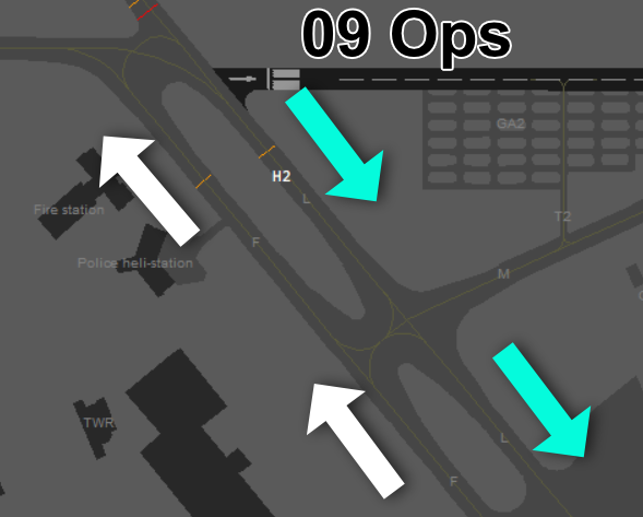
**Stand 8-12:** Often used for virtual Airlines and additional parking positions for all Airlines. **Stand 42-43:** Virtual Airlines and Cargo. **44-48 stands:** mixed use, parking face west (e.g. business jets, long time parking, cargo extended parking space etc.). Taxi-Out stands for aircrafts with a max wingspan of 25m. **De-Icing:** De-icing in Hamburg is provided directly at the parking position. #### Pushback In Hamburg it is very important to use the apron and its taxiways efficiently. It is useful to instruct pushing traffic creative routings to avoid congestion. For medium to high traffic situations: - make use of the orange and blue line on Z1 - consider straight out pushbacks from gates 3+4 into Z4 - 50s stands: to avoid taxi via Z1, consider pushback directions opposite to the usual traffic flow - Stand 10-12, 40+ at 33 departure: pushback face south and taxi to holding point B1 - **caution:** do not push stand 9 face south, as it will block the intersection #### Taxiways**No checkpoints:** The area of responsibility of East Apron includes the holding points. Checkpoints shown on charts are not applicable on VATSIM, as we do not simulate the Hamburg Airport company operating the apron.
**Outbound traffic:** Z1 should be used towards the active departure runway. South to runway 33/05 and north to runway 23/15. Low traffic or creative routings may deviate from that. If possible, separate west/east outbound traffic at different holding points. In medium to high traffic situations, where waiting in sequence is expected at the holding points, consider B1 for heavy aircrafts (up to aircraft code E), to avoid blocking the Z1/Z5 intersection. Holding points A5 and B3 are only used for runway crossings. **Arriving traffic:** Depending on the landing runway, aircrafts will usually enter the East Apron via B6 or A5/A6. The inbound routing is coupled to the outbound orientation of Z1, so it creates a a clockwise or counter-clockwise traffic flow to the gates. Low traffic or creative routings may deviate from that. **Helipad:** Helipad East between B1 and B3 is not used that often or is closed via NOTAMS. Prefer using Helipad West. Departures directly from the parking position are not permitted. All helicopter traffic needs to air-taxi to the helipad, except helicopters based at the police station. ### Hamburg West Apron (EDDH\_W\_GND)East Apron controls this area, if West Apron is offline. Tower, East Apron and Delivery need to be online before West Apron can be staffed.
#### Parking and Pushback The DFS Pack includes the GroundRadar-Plugin which assigns parking positions by the airline and aircraft. In case of blocked gates, traffic flow/management concerns or pilot request, another position can be used. **80s stands - Low Cost Terminal:** The "low-cost" terminal is located at the west apron, taxiway Y1. Airlines like Easy and Ryanair are positioned here. In busy traffic situations, these stands can also be used for all airlines (up to aircraft code D) to relieve the East Apron. **90s stands - Cargo:** Stands 91-93 (taxiway Y3) are intended for heavy aircrafts and block their respective A/B positions. Narrow body airliners with a max-wingspan of 36m shall use one of the A/B positions. **Pushbacks at the northern stands (81, 82, 91) need to stay clear of D1:** Either a pushback face north, straight back or a short pushback face south needs to be issued, since D1 is in the responsibility of Tower. Depending on the departure runway, aircrafts facing north might need extensive coordination, e.g. an intersection take-off or a longer taxi-route with a released taxiway D1. **General Aviation (GA + Apron 4):** General Aviation Parking is between D1 and G (green area). Apron 4 is the General Aviation Terminal (GAT) and is often used by smaller business jets or commercial props.**Movement at GA delegated to Tower (green area):** Taxiing out of and into the general aviation parking area is delegated to tower to ensure a steady traffic flow. Parking positions are not assigned to arriving traffic. Outbound traffic should be handed over to tower when they report ready for pushback or taxi, whichever comes first.
**Apron 5 + 6:** Lufthansa Technik - these aprons are only used on pilot request. Apron 6 taxi out needs to be coordinated with tower. In real life these aprons are private property and often a push/pull out through the gates is needed. This is not applicable on Vatsim. **De-Icing:** De-icing in Hamburg is provided directly at the parking position. **Police and rescue helicopters:** The police helicopters are based at Hamburg Airport east of apron 5 (H Pol1 / H Pol 2), Callsign "Libelle". These helipads are not reachable via air-taxi and can only be used for direct arrival/departures. Pilots will communicate directly with the tower. There are no rescue helicopters located at the airport but within the area of the tower control zone. #### Taxiways **Outbound traffic:** Use G for outbound traffic unless an intersection take-off (e.g. D8/D9) was coordinated. In that case airplanes hold short of D1 while being handed over to Tower. **Arriving traffic:** Expect aircrafts on all possible entry points of your area of responsibility and check the provided stand assignment. If you disagree with the chosen stand, coordinate in time with the other stations. Tower will transfer airplanes on D1 with an instruction to hold short of Y3 or Y1. Clear the traffic on D1 as quick as possible. **Helipads:** Helipad West is the main arrival/departure point for helicopters in Hamburg. Departures directly from the parking position are not permitted. All helicopter traffic needs to air-taxi to the helipad, except helicopters based at the police station. ### Taxiway Restrictions Unless otherwise stated below, taxiways are suited for aircraft code F movements. For information regarding aircraft dimensions consult the [Aircraft Performance Database](https://contentzone.eurocontrol.int/aircraftperformance/default.aspx). ICAO aircraft code definitions can be found at [Skybrary](https://skybrary.aero/articles/icao-aerodrome-reference-code). Euroscope:* Ground View > Functions > Maps > Restrictions* *[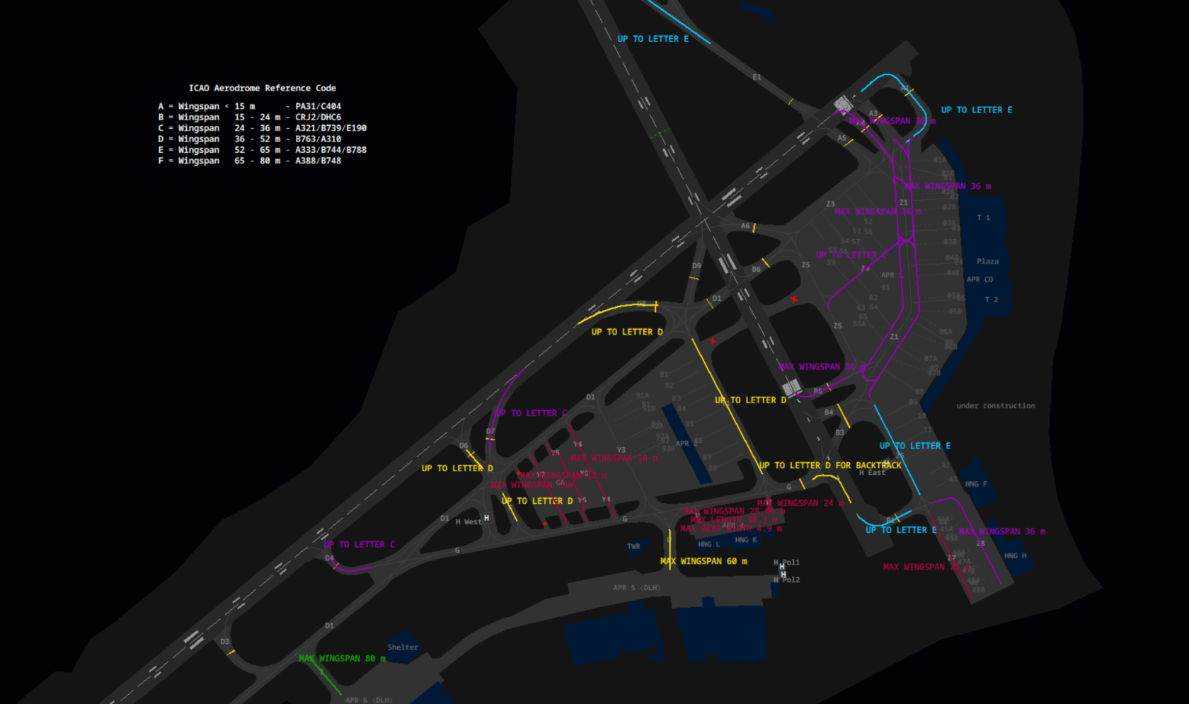](https://knowledgebase.vatsim-germany.org/uploads/images/gallery/2023-10/eddh-taxi-restrictions.png) click to open bigger view* #### Apron East| **Taxiway** | **Restrictions** |
| **Alpha 1** | Aircraft code E or below |
| **Alpha 4** | max wingspan 36m |
| **Bravo 1** | Aircraft code E or below |
| **Bravo 5** | max wingspan 36m, Aircraft code C or below |
| **Zulu 1** | Orange und Blue Line: max wingspan 36m |
| **Zulu 4** | Aircraft code C or below |
| **Zulu 5** | south of Z1: Aircraft code E or below |
| **Zulu 7** | max wingspan 25m |
| **Zulu 8** | max wingspan 36m |
| **Taxiway** | **Restriction** |
| **Foxtrott** | Aircraft code D or below |
| **Golf** | for pushback: Aircraft code D or below |
| **Tango** | max wingspan 80m; >80m tow to Apron 6 |
| **Uniform** | max wingspan 60m; >36m tow to Apron 5 |
| **Victor** | max wingspan 28,65m max length 30,3m landing gear width 4,9m |
| **Whiskey** | max wingspan 24m, **closed** |
| **Yankee 1** | Aircraft code D or below |
| **Yankee 4** | max wingspan 30m |
| **Yankee 5+6** | max wingspan 12m |
| **Yankee 7** | max wingspan 29m |
| **Holding Point** | **Restrictions** |
| **Delta 4** | Aircraft code C or below |
| **Delta 6** | Aircraft code D or below |
| **Delta 7** | Aircraft code C or below |
| **Delta 8** | Aircraft code D or below |
| **Echo 4** | Aircraft code E or below |
| [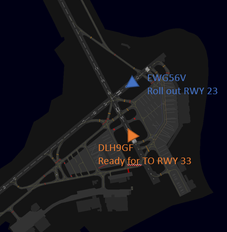](https://knowledgebase.vatsim-germany.org/uploads/images/gallery/2023-11/mafimage.png) | [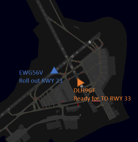](https://knowledgebase.vatsim-germany.org/uploads/images/gallery/2023-11/oIaimage.png) |
| **Runway 33 blocked!** | **Runway 33 clear, a take-off clearance can be issued** |
**Movement at GA delegated to Tower (green area):** Taxiing out of and into the general aviation parking area is delegated to tower to ensure a steady traffic flow. Parking positions are not assigned to arriving traffic. Outbound traffic should be handed off to tower when they report ready for pushback or taxi, whichever comes first.
### Departures **General Departure-Release:** Departures do not have to be released by EDWW (Bremen Radar) unless: - EDWW explicitly restricts departures by time, SID or until further notice - Departures out of the non operational runway config - The first departure after a runway change - The first departure after an unplanned missed approach - Departures using OID or vectored departure **Auto-Handoff:** Hamburg has an auto-handoff to the departure frequency when passing 2000ft, as stated in the charts. A short "bye bye" at the end of the take-off clearance can help vPilots to get the hint. **Spacing:** Departures shall be separated with a minimum of 3nm or wake turbulence separated, whichever is greater. When two aircrafts have the same SID the separation shall be increased to 5nm or wake turbulence separation whichever is greater. Different aircraft performances and climb speeds need to be taken into account. **Efficiency:** Try to sequence departures with alternating SID directions, left/right in relation of the runway track. In case of two westbound departures (different SIDs) out of runway 33, more spacing (5nm) is preferred but not mandatory, as all aircrafts fly the same route until ELSOB. As there are distinct landing and departure runways, use lineups constantly to issue take-off clearances as soon as possible. ### Arrivals **Approaches:** By default, the ILS Approach is used for all arrivals, except runway 33 or coordinated otherwise. **Runway 23 (very often)**: The target spacing is only 3nm on runway 23. In high traffic situations pilots need to vacate as soon as possible. Most of the time the phrase "*taxi left via D1, hold short of runway 33*" is used. **Runway 15 (regularly):** The first exit is E4 to the left. Depending on the spacing on the final and planed parking position, long rollouts might be instructed to vacate left via A6 or right via D9. **Runway 05 (some times):** Same as runway 23 pilots should vacate as soon as possible and be guided onto D1. In this case to have enough time for departures out of runway 33 before the next arrival is on short final. **Runway 33 (only at very strong winds):** This RNP only approach is being avoided as long as possible as its path is directly above Hamburg city. All arriving traffic will taxi via E1 to hold short of runway 23 within the responsibility of the tower.One of your primary objectives with arrivals is to keep the runways useable. Unfortunately some vPilots will hold before the holding line blocking the runway, unless you keep them rolling. Issue taxi instructions as soon as possible.
Handover to apron will take place as early as possible, at the latest when reaching the boundary of responsibility. ### Missed Approaches In case of an unplanned missed approach, the Tower controller shall inform Hamburg East Approach immediately. Traffic will be handed over to Hamburg East Approach after coordination.The next departure is always subject to release, if not coordinated otherwise ([Departure Release](https://knowledgebase.vatsim-germany.org/books/coordination/page/departure-release)).
### Efficiency **Sequencing traffic:** Keep up clearances and rolling instructions. A good sequence on default config (23/33) looks like: - Landing Clearance runway 23 - Lineup runway 33 - Cross D1 traffic at runway 33 and send to East Apron - Takeoff Clearance runway 33 - Taxi arrival on D1 hold short runway 33 ### Reduced Runway Separation (RRS) Hamburg Airport (EDDH) is approved to apply the following reduced runway separation minima during day and night:| **Runway** | CAT 1 following a departing CAT 1 or 2 | CAT 2 following a departing CAT 1 or 2 | CAT 1 to 3 following a departing CAT 3 |
| RWY 05/23 | 600 m | 1500 m | 2400 m |
| RWY 15/33 | 600 m | 1500 m | 2400 m |
| **VRP** | **NAV** |
|---|---|
| **N1** | East abeam Kisdorf/Henstedt-Ulzburg |
| **N2** | Large roundabout at federal street B432 |
| **D** | Highway junction A1 and A24 |
| **T1** | Bridge of federal street B75 leading above the railway tracks |
| **T2** | Track harp the cargo rail station Hamburg Süd (Veddel beim Spreehafen) |
| **H** | Marina/Yachthafen Hamburg, River Elbe |
| **P1** | Highway exit A23 Pinneberg-Nord, Radio Tower |
| **P2** | Highway junction A7 and A23 |
Tower, East Apron, and Delivery need to be online before the VFR Tower can be staffed. Usually only staffed at the Hamburg Harbor Festival and the Overload Real-life Event.
In reality the Hamburg VFR Tower is a station to provide precise traffic information using radar coverage and to organize the VFR traffic flow efficiently. Its area of responsibility includes all VFR flights in the area of the control zone, as well as entry/exit/through flights. Traffic circuits and runway clearances remain the responsibility of the normal EDDH\_TWR. In order to provide traffic information with exact and verified altitude information, the EDDH\_VFR\_TWR may assign squawks and delegate the squawk assignment for departing traffic from Hamburg to Apron/Tower. Departures are handed over to the radar tower after takeoff. Individual arrangements can be made for handovers of approaches to Hamburg but for certain runway configurations the Outer Alster is recommended as a visual reference point in the south of the airport. The efficient handling of traffic can only be guaranteed through good cooperation and coordination between the tower and the radar tower. ### Helicopters Departures directly from the parking position are not permitted. All helicopter traffic needs to air-taxi from and to the helipad, except helicopters based at the police station. **Helipad West:** Main arrival/departure point for helicopters in Hamburg. **Helipad East:** Helipad East between B1 and B3 is not used that often or is closed via NOTAMS. Prefer using Helipad West. **Police helicopters:** The police helicopters are based at Hamburg Airport east of apron 5 (H Pol1 / H Pol 2), Callsign "Libelle". These helipads are not reachable via air-taxi and can only be used for direct arrival/departures. Pilots will communicate directly with the tower. **Rescue helicopters:** There are no rescue helicopters located at the airport but within the area of the tower control zone. In EuroScope the surrounding hospitals with helicopter platforms are marked as square with an x inside. The names can be activated with ALT-H. [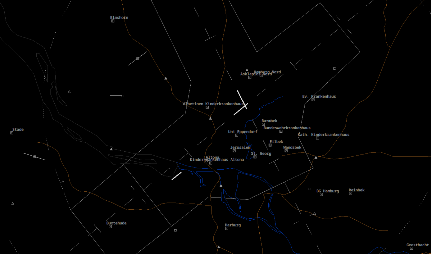](https://knowledgebase.vatsim-germany.org/uploads/images/gallery/2024-05/helipads-eddh.png) ### Low Visibility Operations (LVO) At Hamburg, the following runway configurations are allowed during LVO: - Departures 33\*, Arrivals 23 (preferred configuration) - Departures 23, Arrivals 23 (alternative configuration) Single Runway Operations during LVO requires a larger spacing between arriving traffic. Therefore 33 Departures, 23 Arrivals is the preferred runway configurations whenever RVR and wind permit.\* Note: Runway 33 can only used for departing traffic if the RVR is not less than 150 m.
When the weather condition requires low visibility operations the use shall be announced in the ATIS. At runway 23 the CAT II / CAT III needs to be used.Use ***&lvp*** in the ATIS maker URL or "LOW VIS OPS" flag in the NOTAM menu of vATIS.
# Arrival| **Hamburg** | HAM | EDDH\_APP | 120.540 | Primary Station |
| **Arrival** | DHAT | EDDH\_F\_APP | 118.205 | -- |
| **Hamburg West** | HAMW | EDDH\_W\_APP | 134.255 | Relief Station/Event |
**By default, HAM shall not cross-couple frequency 134.255.**
**Area of Responsibility:** The Hamburg Approach airspace reaches up to FL105 and covers Hamburg Fuhlsbüttel (EDDH), Hamburg Finkenwerder (EDHI) and Lübeck Blankensee (EDHL).The airports Lübeck Blankensee (EDHL) and Hamburg Finkenwerder (EDHI) are covered by HAM in the absence of a tower. Operations at Hamburg Finkenwerder (EDHI) can be in parts/temporarily delegated to EDDH\_TWR, e.g. for a touch and go of a VFR pilot in the EDDH\_TWR CTR.
**[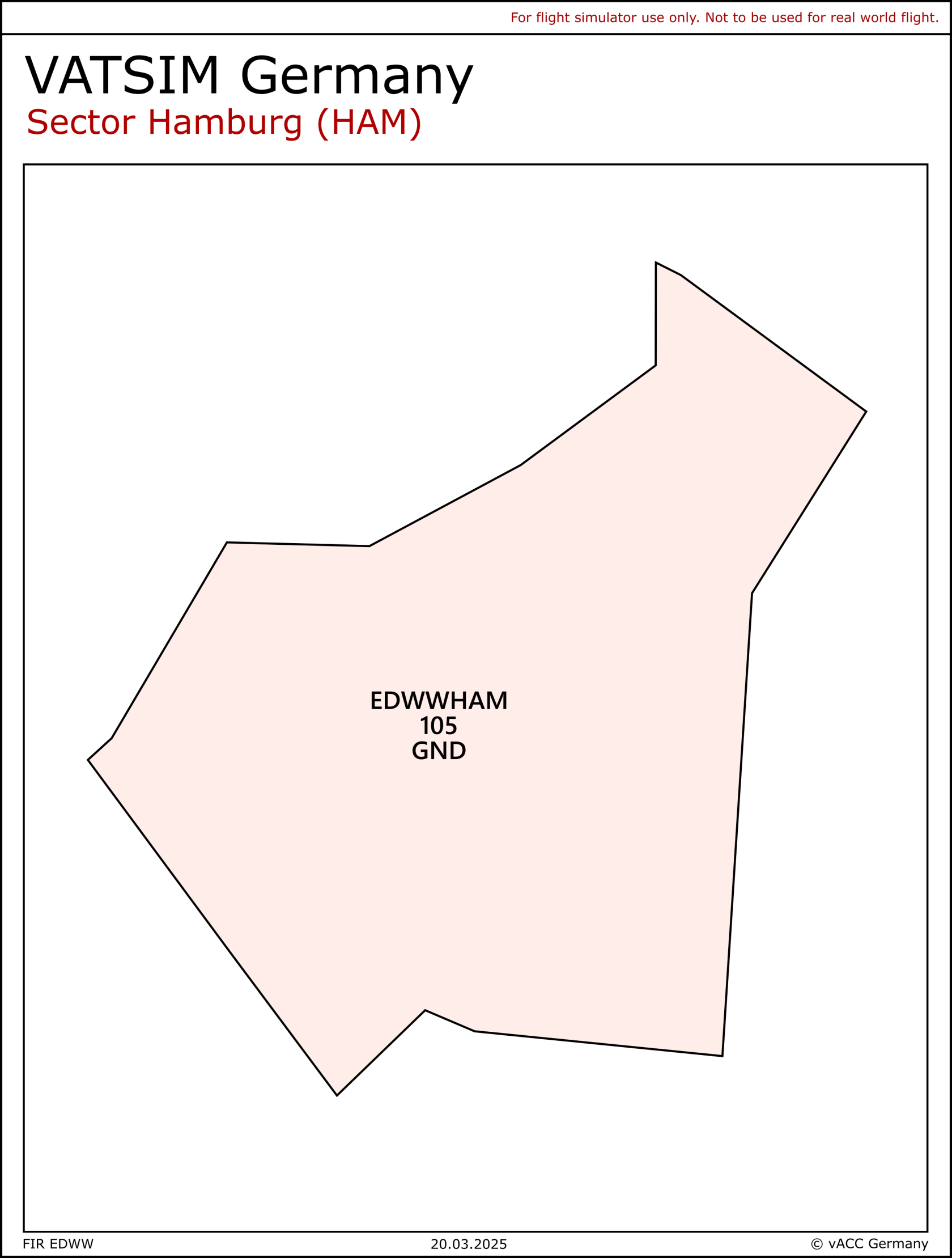](https://knowledgebase.vatsim-germany.org/uploads/images/gallery/2025-02/ham.png)** **Airspace:** The inner ring of airspace C starts at 2500 feet MSL and ends at FL100. Additional rings are similarly dimensioned and start at 3500/4500/5500ft MSL or FL75 respectively. In order to keep arriving IFR traffic inside protected airspace, a TMZ located north of NOLGO between FL60/FL75 and FL100 has been set up.Airspace C (HX) sectors east and west of Hamburg are generally considered active and may be deactivated on pilot's request. Airspace D (HX) west of Finkenwerder is generally active if RWY 05 is in use at Hamburg-Finkenwerder.
[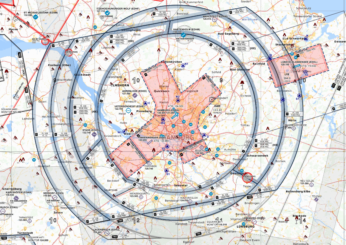](https://knowledgebase.vatsim-germany.org/uploads/images/gallery/2024-01/eddh-tma.png) *Charlie + TMZ Airspace of Hamburg and Lübeck - © [openflightmaps.org](https://www.openflightmaps.org/)* **Minimum Vector Altitude:** The minimum vector altitude can be displayed in the DFS Pack with *Alt + M.* ### Arrivals **Approach types:| **Runway** | **SRA** | **RNP** | **ILS CAT I / LOC** | **ILS CAT II** | **ILS CAT III** |
| **23** | |||||
| **05** | |||||
| **15** | |||||
| **33** |
If possible, all flights to/from Hamburg and Finkenwerder should be kept within controlled airspace (TMZ/D/C). In Lübeck, the procedure is not applicable due to the airspace structure.
**SRA:** At EDDH and EDHI, surveillance radar approaches may be offered on the pilot's request. Check the following tables for the temperature-corrected approach altitudes ([Phraseology SRA](https://knowledgebase.vatsim-germany.org/link/1363#bkmrk-anfluganweisungen-sr)).| Temperatur | 10 °C or more | 9 °C to 0 °C | -1 °C to -10 °C | -11 °C to -20 °C | -21 °C to -30 °C |
| **OCA (CAT A-D)** | 770 | 790 | 820 | 840 | 870 |
| **10 NM** | 3100 | 3200 | 3300 | 3400 | 3600 |
| **9 NM** | 2800 | 2900 | 3000 | 3100 | 3200 |
| **8 NM** | 2500 | 2600 | 2700 | 2800 | 2900 |
| **7 NM** | 2200 | 2300 | 2400 | 2400 | 2500 |
| **6 NM** | 1900 | 2000 | 2000 | 2100 | 2200 |
| **5 NM** | 1600 | 1700 | 1700 | 1800 | 1800 |
| **4 NM** | 1300 | 1300 | 1400 | 1400 | 1500 |
| **3 NM** | 1000 | 1000 | 1100 | 1100 | 1100 |
| **2,0 NM** | 650 | 670 | 690 | 710 | 730 |
| **1,5 NM** | 490 | 510 | 530 | 540 | 560 |
| **1,0 NM** | 340 | 350 | 360 | 370 | 380 |
| **0,5 NM** | 190 | 190 | 200 | 210 | 210 |
| Temperatur | 10 °C or more | 9 °C to 0 °C | -1 °C to -10 °C | -11 °C to -20 °C | -21 °C to -30 °C |
| **OCA (CAT A-D)** | 630 | 650 | 670 | 690 | 710 |
| **10 NM** | 3200 | 3300 | 3400 | 3500 | 3600 |
| **9 NM** | 2800 | 2900 | 3000 | 3100 | 3200 |
| **8 NM** | 2500 | 2600 | 2700 | 2800 | 2900 |
| **7 NM** | 2200 | 2300 | 2400 | 2500 | 2500 |
| **6 NM** | 1900 | 2000 | 2100 | 2100 | 2200 |
| **5 NM** | 1600 | 1700 | 1700 | 1800 | 1800 |
| **4 NM** | 1300 | 1400 | 1400 | 1400 | 1500 |
| **3 NM** | 1000 | 1000 | 1100 | 1100 | 1100 |
| **2,0 NM** | 670 | 690 | 710 | 730 | 750 |
| **1,5 NM** | 520 | 530 | 550 | 560 | 580 |
| **1,0 NM** | 360 | 370 | 380 | 390 | 400 |
| **0,5 NM** | 210 | 220 | 220 | 230 | 230 |
| Temperatur | 10 °C or more | 9 °C to 0 °C | -1 °C to -10 °C | -11 °C to -20 °C | -21 °C to -30 °C |
| **OCA (CAT A-D)** | 630 | 650 | 680 | 700 | 720 |
| **10 NM** | 3100 | 3200 | 3400 | 3500 | 3600 |
| **9 NM** | 2800 | 2900 | 3000 | 3100 | 3200 |
| **8 NM** | 2500 | 2600 | 2700 | 2800 | 2900 |
| **7 NM** | 2200 | 2300 | 2400 | 2400 | 2500 |
| **6 NM** | 1900 | 2000 | 2000 | 2100 | 2200 |
| **5 NM** | 1600 | 1700 | 1700 | 1800 | 1800 |
| **4 NM** | 1300 | 1400 | 1400 | 1400 | 1500 |
| **3 NM** | 1000 | 1000 | 1100 | 1100 | 1100 |
| **2,0 NM** | 660 | 680 | 700 | 720 | 740 |
| **1,5 NM** | 510 | 520 | 540 | 550 | 570 |
| **1,0 NM** | 350 | 360 | 370 | 380 | 390 |
| **0,5 NM** | 200 | 210 | 210 | 220 | 220 |
| Temperatur | 10 °C or more | 9 °C to 0 °C | -1 °C to -10 °C | -11 °C to -20 °C | -21 °C to -30 °C |
| **OCA (CAT A-D)** | 1270 | 1310 | 1350 | 1390 | 1430 |
| **10 NM** | 3100 | 3200 | 3300 | 3500 | 3600 |
| **9 NM** | 2800 | 2900 | 3000 | 3100 | 3200 |
| **8 NM** | 2500 | 2600 | 2700 | 2800 | 2900 |
| **7 NM** | 2200 | 2300 | 2400 | 2400 | 2500 |
| **6 NM** | 1900 | 2000 | 2000 | 2100 | 2200 |
| **5 NM** | 1600 | 1700 | 1700 | 1800 | 1800 |
| **4 NM** | 1300 | 1300 | 1400 | 1400 | 1500 |
| **3 NM** | 1000 | 1000 | 1100 | 1100 | 1100 |
| **2,0 NM** | 650 | 670 | 690 | 710 | 730 |
| **1,5 NM** | 500 | 510 | 530 | 540 | 560 |
| **1,0 NM** | 350 | 360 | 370 | 380 | 390 |
| **0,5 NM** | 190 | 200 | 200 | 210 | 210 |
| Temperatur | 10 °C or more | 9 °C to 0 °C | -1 °C to -10 °C | -11 °C to -20 °C | -21 °C to -30 °C |
| **OCA (CAT A)** | 550 | 570 | 590 | 610 | 630 |
| **OCA (CAT B)** | 560 | 580 | 600 | 620 | 640 |
| **OCA (CAT C)** | 580 | 600 | 620 | 640 | 660 |
| **OCA (CAT D)** | 600 | 620 | 640 | 660 | 680 |
| **10 NM** | 3100 | 3200 | 3300 | 3400 | 3500 |
| **9 NM** | 2800 | 2900 | 3000 | 3100 | 3200 |
| **8 NM** | 2500 | 2600 | 2700 | 2800 | 2800 |
| **7 NM** | 2200 | 2300 | 2300 | 2400 | 2500 |
| **6 NM** | 1900 | 200 | 2000 | 2100 | 2100 |
| **5 NM** | 1600 | 1600 | 1700 | 1700 | 1800 |
| **4 NM** | 1300 | 1300 | 1400 | 1400 | 1500 |
| **3 NM** | 1000 | 1000 | 1000 | 1100 | 1100 |
| **2,0 NM** | 630 | 650 | 670 | 690 | 710 |
| **1,5 NM** | 480 | 490 | 510 | 520 | 540 |
| **1,0 NM** | 330 | 340 | 350 | 360 | 370 |
| **0,5 NM** | 170 | 180 | 180 | 190 | 190 |
| Temperatur | 10 °C or more | 9 °C to 0 °C | -1 °C to -10 °C | -11 °C to -20 °C | -21 °C to -30 °C |
| **OCA (CAT A-C)** | 590 | 610 | 630 | 650 | 670 |
| **OCA (CAT D)** | 760 | 780 | 810 | 830 | 860 |
| **10 NM** | 3100 | 3200 | 3300 | 3400 | 3500 |
| **9 NM** | 2800 | 2900 | 3000 | 3100 | 3200 |
| **8 NM** | 2500 | 2600 | 2700 | 2800 | 2800 |
| **7 NM** | 2200 | 2300 | 2300 | 2400 | 2500 |
| **6 NM** | 1900 | 2000 | 2000 | 2100 | 2100 |
| **5 NM** | 1600 | 1600 | 1700 | 1700 | 1800 |
| **4 NM** | 1300 | 1300 | 1400 | 1400 | 1500 |
| **3 NM** | 1000 | 1000 | 1000 | 1100 | 1100 |
| **2,0 NM** | 630 | 650 | 670 | 690 | 710 |
| **1,5 NM** | 480 | 490 | 510 | 520 | 540 |
| **1,0 NM** | 330 | 340 | 350 | 360 | 370 |
| **0,5 NM** | 170 | 180 | 180 | 190 | 190 |
Sector Hamburg West shall only be opened if the traffic situation requires. **The opening and closure of this position shall be announced to sectors ALR, HEI, EID and FRI as well as to Hamburg Tower, Hamburg Ground and Finkenwerder Tower.**
When online, Hamburg West will control inbound traffic to EDDH/EDHI via RIBSO. During 23 operations, Hamburg West shall also be responsible for inbound traffic via BOGMU. During 05 operations, HAMW is also responsible for inbound traffic via BOGMU when the northern downwind shall be used (N STARs). **In any case, sectors HAM or HAMW shall inform sector HEI and EID about the responsible sector for inbound traffic via BOGMU.** Additionally, Hamburg West will take over departing traffic from EDDH and EDHI via ELSOB, HABFU, IDEKO and WSN. OIDs are subject to coordination with HAM.Comparable to Hamburg Arrival, Sector Hamburg West does not have its own AoR but operates within the limits of the AoR of sector HAM. Hamburg West shall apply agreements to other sectors as described in the LOP of EDWW ACC for sector HAM. Traffic in the responsibility of HAMW is fully released from HAM.
### Target separation *In principle, these values are to be understood as minima and should be extended upon request from a tower for VFR traffic. The separations are chosen in a way that the gaps for departures are sufficiently large. Smaller spacing values can be coordinated at any time.* **The wake turbulence separation must be assured!**| Departure Runway | Arrival Runway | Target Separation (nm) |
| 33 | 23 | 3 |
| 33 | 05 | 5 |
| 23 | 15 | 5 |
| 05 | 15 | 5 |
| 05 | 05 | 6 |
| 15 | 15 | 6 |
| 23 | 23 | 6 |
| 33 | 33 | 6 |
| 33 (LVO) | 23 (LVO) | 7 |
| 23 (LVO) | 23 (LVO) | 10 |
**Before staffing this airport for the first time:** Obtain a successful grade at the self enrollment Moodle course: **[EDDV - Hannover GND (S1) + Tower (S2)](https://moodle.vatsim-germany.org/course/view.php?id=51)**.
Hannover Airport is the ninth-largest airport in Germany and the most important airport for Lower Saxony and the area around Hannover. The airport handles passenger and cargo traffic. One of the most important airlines is TuiFly, with its home base. Furthermore, Hannover is a hub for FedEx and night airmail service in Germany. For this Hannover is a 24h airport for all aircraft with noise certificate in accordance with ICAO Annex 16, Volume 1, Chapter 3, 4 or 14. ### Hannover ATC Stations| **Station** | **Station ID** | **Login** | **Frequency** | **Remark** |
| **ATIS** | ADV | EDDV\_ATIS | 136.575 | -- |
| **Delivery** | DVL | EDDV\_DEL | 120.405 | -- |
| **Ground** | DVG | EDDV\_GND | 121.955 | -- |
| **Tower** | DVT | EDDV\_TWR | 120.180 | -- |
| **Hannover** | HAN | EDDV\_APP | 119.490 | -- |
| **Arrival** | DVAT | EDDV\_F\_APP | 119.605 | -- |
| **Departures/hour** | **Arrivals/hour** | **Global/hour** |
| 40 | 40 | 60 |
| Departure RWY | Filed Flight Plan via | Re-clearance via | Alias Command |
| 27R or 27L | NORTA **P605 ELNAT** | TOLTA DCT WERRA flight planned route. | .rctolta-werra |
| NORTA **P12 WRB** | TOLTA DCT WRB flight planned route. | .rctolta-wrb | |
| 09R or 09L | TOLTA | NORTA DCT TOLTA flight-planned route | .rcnorta |
The vSID will automatically choose the correct SID per runway, but will highlight any SID where a re-clearance is required (purple colour). In this case, Hannover Delivery shall issue the re-clearance and amend the flight plan accordingly.
### OIDs As all SIDs out of Hanover are for RNAV-capable aircraft only, certain contingency procedures for non-RNAV aircraft need to be applied. For non-RNAV aircraft intending to depart IFR out of EDDV, so-called Omnidirectional Instrument Departures (OIDs) will be used instead. These OIDs will guide the departing aircraft on runway heading until reaching 2400 ft. Thereafter, the departing traffic will continue as cleared by ATC. Further information is available here: [https://knowledgebase.vatsim-germany.org/link/1167#bkmrk-omnidirectional-inst](https://knowledgebase.vatsim-germany.org/link/1167#bkmrk-omnidirectional-inst) The further clearance is subject to the clearance coordinated with Bremen Radar.**All EDDV OIDs shall be coordinated with Bremen Radar (sector HAN) before IFR clearance is issued.**
Non-RNAV traffic is expected to file EDDV DCT SAS (RWYs 09) or EDDV DCT VAXEV (RWYs 27) in the F-Plan and to inform ATC when requesting clearance. The initial climb for all OIDs is 4000 ft. ### Runway Assignment The departure runway mainly depends on the aircraft type and the pilots preference. - Heavy aircraft (e.g. A332, B748, B763) shall depart from runway 09L/27R - *avoid* crossing departures: northbound departures should depart from 09L/27R - RWY Config 09: VAXEV departures should depart from runway 09L Delivery is responsible for an appropriate runway assignment, so each runway has an equal workload. ### Low Visibility Operations (LVO) At Hannover, the following runway configuration is to be used during LVO: - Departures 09R/27L\*, Arrivals 09L/27R Departures may request runway 09L/27R for performance reasons. In this case, a larger arrival spacing shall be by Tower requested to accommodate the departing traffic in between.\* Note: Runway 09R/27L can only used for departing traffic if the RVR is not less than 350 m. If the RVR is below 350 m, runway 09L/27R shall be the only runway in use for both departing and arriving traffic.
### Delays and Startup **Delay of traffic:** In high traffic situations, it may be necessary for departing traffic to be held back. In addition, Delivery shall make arrangements to comply with restrictions imposed by other airports through notice on the ECFMP Discord, coordination, etc. **Startup:** A startup shall be granted if no major traffic delays are expected. When allocating startups linked to times, the airport specific rate of 40 departures per hour can be used as a basis. ### Specials **Vectored and visual departures:** The use of vectored or visual departures requires prior coordination with the responsible radar station. An initial altitude to climb shall be provided. **IFR local flights:** IFR local flights are coordinated with the responsible radar controller, who may instruct a different departure procedure, possibly vectored departures. ### vSID Plugin Commands The following plugin commands for vSID are available at EDDV:| **Command** | **Explanation** |
| .vsid rule eddv low (disabled by default) | When enabled, runway 09R/27L will be preferred for all medium and light aircraft (disregarding the standard runway assignment). |
| .vsid area eddv gat | This will clear all aircraft at the GA-Aprons according to the standard runway assignment (09L/27R will not be preferred anymore). |
| **Terminal** | **Positions** | **Airlines** |
|---|---|---|
| **A** | **1 - 6** | Star Alliance (e.g. DLH, SWR) and EWG, AFR, KLM |
| **B** | **7 - 12** | touristic carriers: THY, CXI, SXS |
| **C** | **13 - 20** | TUI and CFG |
| **Cargo** | **45 - 61** | Cargo (e.g. ASL, ABR) |
| **GA Apron** | **Restriction** |
|---|---|
| **GA1** | max wingspan 20 m |
| **GA2** | max wingspan 15 m |
| **GA3** | max wingspan 36 m, above 29 m towing required |
| [](https://knowledgebase.vatsim-germany.org/uploads/images/gallery/2022-09/VDIgrafik.png) | [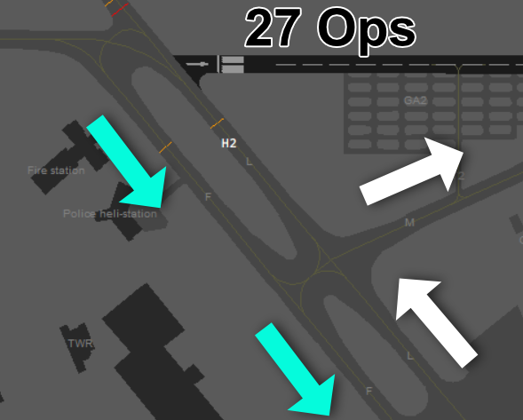](https://knowledgebase.vatsim-germany.org/uploads/images/gallery/2022-09/UeCgrafik.png) |
| *Standard routing during 09 operations* | *Standard routing during 27 operations* |
| **Runway** | **WTC** | **Intersection** |
|---|---|---|
| **27L** | M (+ H) | A |
| L | B | |
| **27R** | H | M |
| L + M | N | |
| **09R** | M (+H) | E |
| L | D | |
| **09L** | H | **H** + G |
| M | **J** + K + Kto | |
| L | **K** + Kto |
| **Helipad** | **Location** | **Conditions** |
|---|---|---|
| **Helipad 1** | crossing taxiways A and C | no traffic on C no traffic on A between stands 45 and 41 |
| **Helipad 2** | on taxiway L, south of runway 09C | no arrivals/departures from 09C/27C no traffic on F and L between G and M |
| **Helipad 3** | on taxiway M between T2 and O | no arrivals/departures from 09C/27C no traffic on M between T2 and O |
| **Taxiway** | **Restriction** |
|---|---|
| **K** | between RWY and Kto, ICAO class C or less |
| **Kto** | no A346, A35K, B773, B77L |
| **L and F** | dual use: wingspan <70 m no A388, B779, A124, A225 |
| **J** | no A346 |
| **N** | only medium except A400M, B752, B753 |
| **O** | max. wingspan 20 m |
| **P** | max. wingspan 17 m |
| **Q** | max. wingspan 36 m |
\* Note: Runway 09R/27L can only used for departing traffic if the RVR is not less than 350 m. If the RVR is below 350 m, runway 09L/27R shall be the only runway in use for both departing and arriving traffic.
When the weather condition requires low visibility operations the use shall be announced in the ATIS.use ***&lvp*** in the ATIS maker URL or "LOW VIS OPS" flag in the NOTAM menu of vATIS
# Tower Hannover Tower is responsible for all arriving and departing traffic. The top level of the airspace D control zone is 2500ft MSL. Above this altitude, airspace D (not CTR) and C covers this area around Hannover within responsibility of Bremen Radar (Hannover). [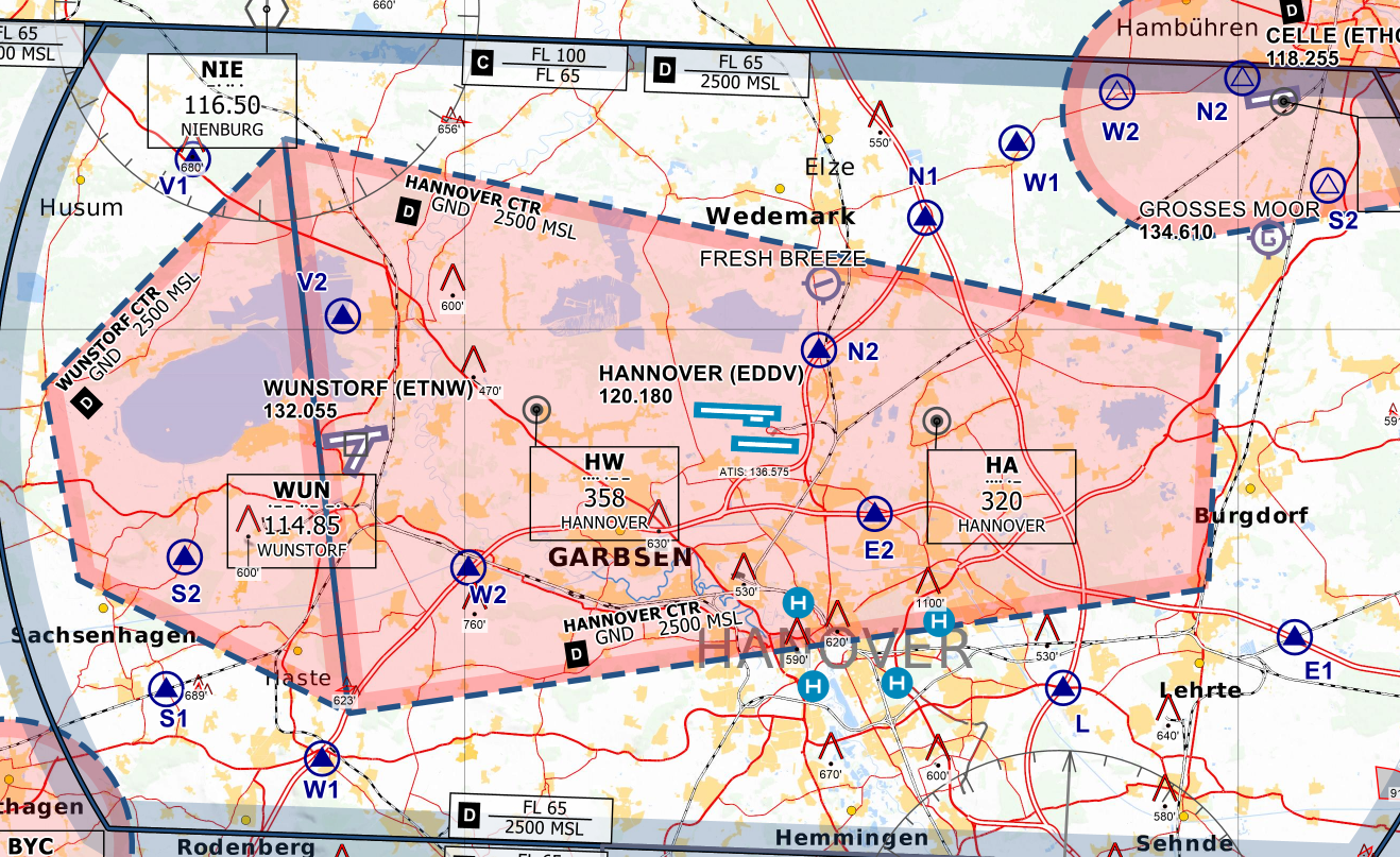](https://knowledgebase.vatsim-germany.org/uploads/images/gallery/2022-09/cqDgrafik.png)*Controlzone of Hannover Airport and Wunstorf - © [openflightmaps.org](https://www.openflightmaps.org/)* **Wunstorf:** West of Hannover, the military airbase Wunstorf (ETNW) exists. Parts of the Hannover CTR may need to be delegated to Wunstorf Tower or Wunstorf Radar depending on the runway configurations and airport conditions (see below). When ETNW is offline, VFR traffic already in contact with Hannover Tower may be delegated to Hannover Tower from Bremen Radar entirely (e.g. for touch and go from EDDV). Top-down service shall not be provided by Hannover Tower. On request from Bremen Radar, it may be necessary to issue departure stops for IFR traffic from/to ETNW. The Hannover Tower control zone shall be delegated as depicted in the paragraph below:Wunstorf TWR shall inform Hannover TWR immediately about the opening and closure of Wunstorf CTR. Both TWRs shall terminate the status of the ATS delegation (see below).
##### EDDV RWYs 09 [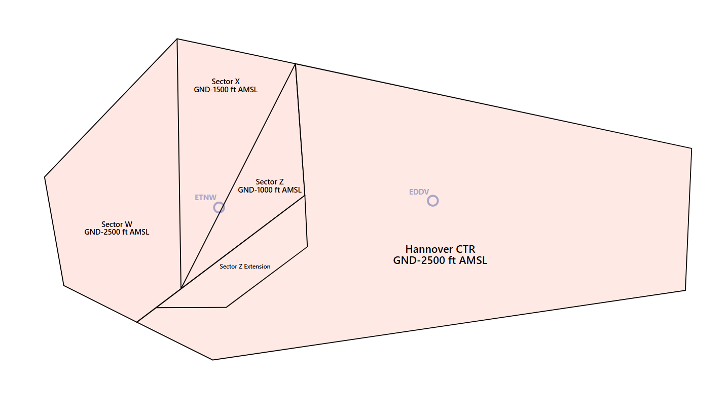](https://knowledgebase.vatsim-germany.org/uploads/images/gallery/2024-10/msedge-ffmuh1iaag.png)| Status | Condition | Sector | Responsibility |
| Victor 09 | If CTR Hannover is VMC **and** Wunstorf airport is VMC. | W, X & Z | Wunstorf TWR |
| Full CTR | If CTR Hannover is IMC **or** Wunstorf airport are IMC. | W, X & Z | Hannover TWR |
| Status | Condition | Sector | Responsibility |
| Victor 27 | If CTR Hannover is VMC **and** Wunstorf airport is VMC. | Y & Z | Wunstorf TWR |
| West to APP | If Wunstorf APP is active **and either** CTR Hannover is IMC **or** Wunstorf airport is IMC | Y | Wunstorf APP |
| Z | Hannover TWR | ||
| Full CTR | If Wunstorf APP is not active **and either** CTR Hannover is IMC **or** Wunstorf airport is IMC | Y & Z | Hannover TWR |
Hannover Tower shall coordinate runway changes with Wunstorf Tower and Wunstorf Radar immeditely!
When runway 27 is in use, **ILS-Z** shall be announced in the ATIS.
**Conditions for Runway 09C/27C:** The small runway 09C/27C can not be used all the time and for all aircraft. There are following restrictions: - MTOM below 5700 kg, including motor gliders and ultralight aircraft - only for VFR traffic - daylight operation only, SR-30 till SS+30 ### Specialties The airport layout with its parallel dependent runway offers some opportunities to increase the efficiency. **Standard Separation:** The standard separation is 4,5nm diagonally on both runways and 6nm on a single runway. Approach will coordinate or Tower will release a reduction. **Special Separation:** With the distance between runway 09R/27L and 09L/27R, radar is allowed to separate arriving traffic with minimum 1,5 nm diagonally. The radar controller is responsible for creating positive separation. Dependent parallel approaches are allowed when both aircraft use an ILS approach.Clearances can be issued even with active clearances for takeoff or landing on the other parallel runway, as long as there will be positive separation all the time including possible go-arounds. Traffic can be considered landed when ground speed reduces noticeably. Special conditions for VFR traffic see below.
Additionally, under few conditions it is allowed to reduce the lateral separation on one runway to 2,5 nm. - preceding aircraft is same or lower wake turbulence category and not heavy - runway is dry - tower can see all exits visually or with ground radar *Note: all reductions of the separation as stated above are coordinated with Tower and are not the standard procedure.* ## Delegation to Ground [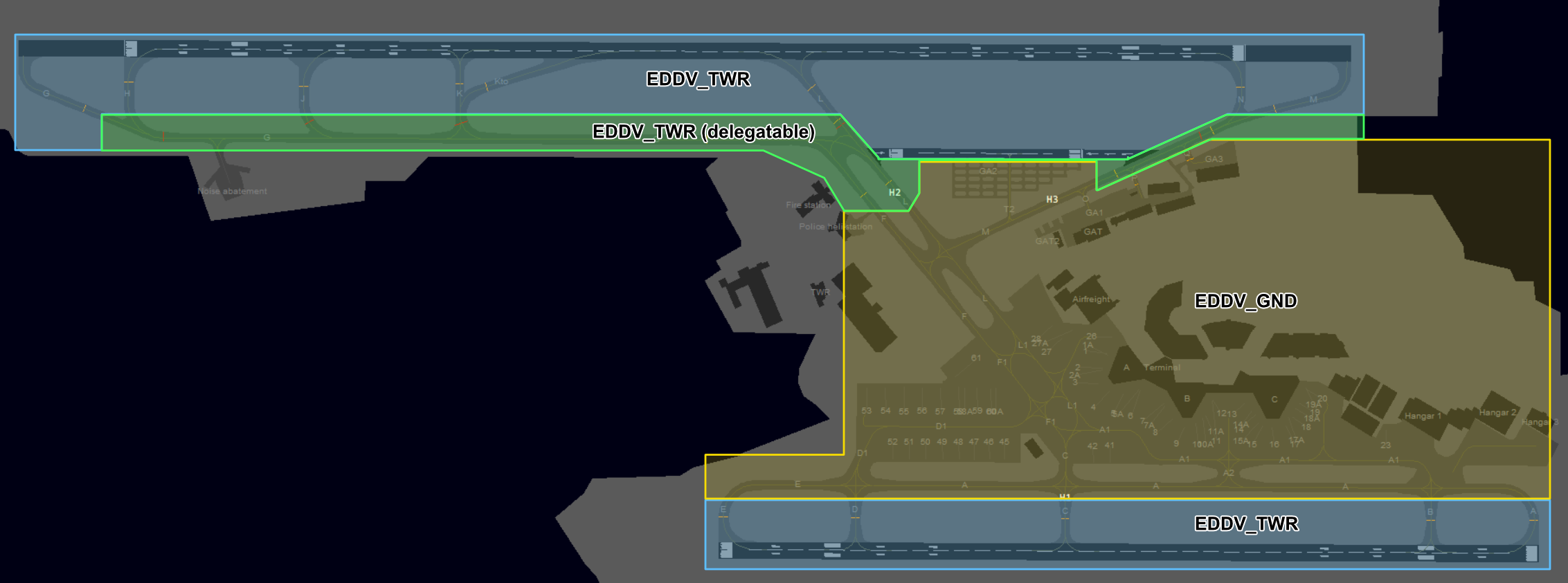](https://knowledgebase.vatsim-germany.org/uploads/images/gallery/2022-09/If2grafik.png) *Area of Responsibility at Hannover Airport* The area north of runway 09C/27C (including taxiways M and G) can be delegated to Hannover Ground. Tower shall decide which of these crossing options shall be applied. 1. General release for crossings until further notice, Tower shall inform Ground when traffic is approaching runway 09C/27C 2. Each crossing is coordinated When the area is in responsibility of Tower (default), the Tower controller is responsible to assign the intersections of the north runway. Ground Controllers will only clear to hold short of 09/27C. ### Departures There are standard intersections which should be used for traffic departing from Hannover. In case of pilot request, insert the non standard intersection into the remarks field.| **Runway** | **WTC** | **Intersection** |
|---|---|---|
| **27L** | M (+ H) | A |
| L | B | |
| **27R** | H | M |
| L + M | N | |
| **09R** | M (+H) | E |
| L | D | |
| **09L** | H | **H** + G |
| M | **J** + K + Kto | |
| L | **K** + Kto |
One of your primary objectives with arrivals is to keep the runways useable. Unfortunately some vPilots will hold before the holding line blocking the runway, unless you keep them rolling. Issue taxi instructions as soon as possible (09L/27R) or advice to hold behind the holding line while giving a handoff to Ground (09R/27L).
### Missed Approaches In case of an unplanned missed approach, the Tower controller shall inform Bremen Radar (Hannover) immediately. Traffic will be handed over to Hannover Approach after coordination.The next departure is always subject to release, if not coordinated otherwise ([Departure Release](https://knowledgebase.vatsim-germany.org/books/coordination/page/departure-release)).
### Efficiency **Independent lineups:** With the standard intersection described above, independent lineups are only authorized for runway 09L between G and J/K/Kto, H and K/Kto. ### Reduced Runway Separation (RRS) Hannover Airport (EDDV) is approved to apply the following reduced runway separation minima during day and night:| **Runway** | CAT 1 following a departing CAT 1 or 2 | CAT 2 following a departing CAT 1 or 2 | CAT 1 to 3 following a departing CAT 3 |
| RWY 09L/27R | 600 m | 1500 m | 2400 m |
| RWY 09R/27L | 600 m | 1500 m | --- |
| **VRP** | **N1** | **N2** | **E1** | **E2** | **L** | **W1** | **W2** |
|---|---|---|---|---|---|---|---|
| **NAV** | Highway junction A7 and A352 | Highway exit A352 near Kaltenweide | Crossing railway with A2 | Small lakes near A2 | Highway exit A7 to B65 | Highway exit A2 to B65 | Highway A2 crossing with Mittellandkanal |
**Runway usage:** VFR traffic on the left or right runway is independent to IFR traffic on the other runway but shall get traffic information. Departures from the center runway (VFR only) need to be wake turbulence separated from runway 09L/27R.
##### Helicopters **Helipads:** Hannover has three helipads at the airport which can be used for arriving and departing helicopters. Tower shall coordinate with Ground to achieve spacing between arriving or departing helicopters and taxing traffic, since the helipads are on the taxiways.| **Helipad** | **Location** | **Conditions** |
|---|---|---|
| Helipad 1 | crossing taxiways A and C | no traffic on C no traffic on A between stands 45 and 41 |
| Helipad 2 | on taxiway L, south of runway 09C | no arrivals/departures from 09C/27C no traffic on F and L between G and M |
| Helipad 3 | on taxiway M between T2 and O | no arrivals/departures from 09C/27C no traffic on M between T2 and O |
\* Note: Runway 09R/27L can only used for departing traffic if the RVR is not less than 350 m. If the RVR is below 350 m, runway 09L/27R shall be the only runway in use for both departing and arriving traffic.
When the weather condition requires low visibility operations the use shall be announced in the ATIS.use ***&lvp*** in the ATIS maker URL or "LOW VIS OPS" flag in the NOTAM menu of vATIS
# Arrival **Area of Responsibility:** The Hannover Approach airspace reaches up to FL105 and covers several airports. Civil aerodromes in the area of responsibility are Hannover (EDDV) and Braunschweig-Wolfsburg (EDVE). There are also the military airports Wunstorf (ETNW), Celle (ETHC), Bückeburg (ETHB) and Fassberg (ETHS). [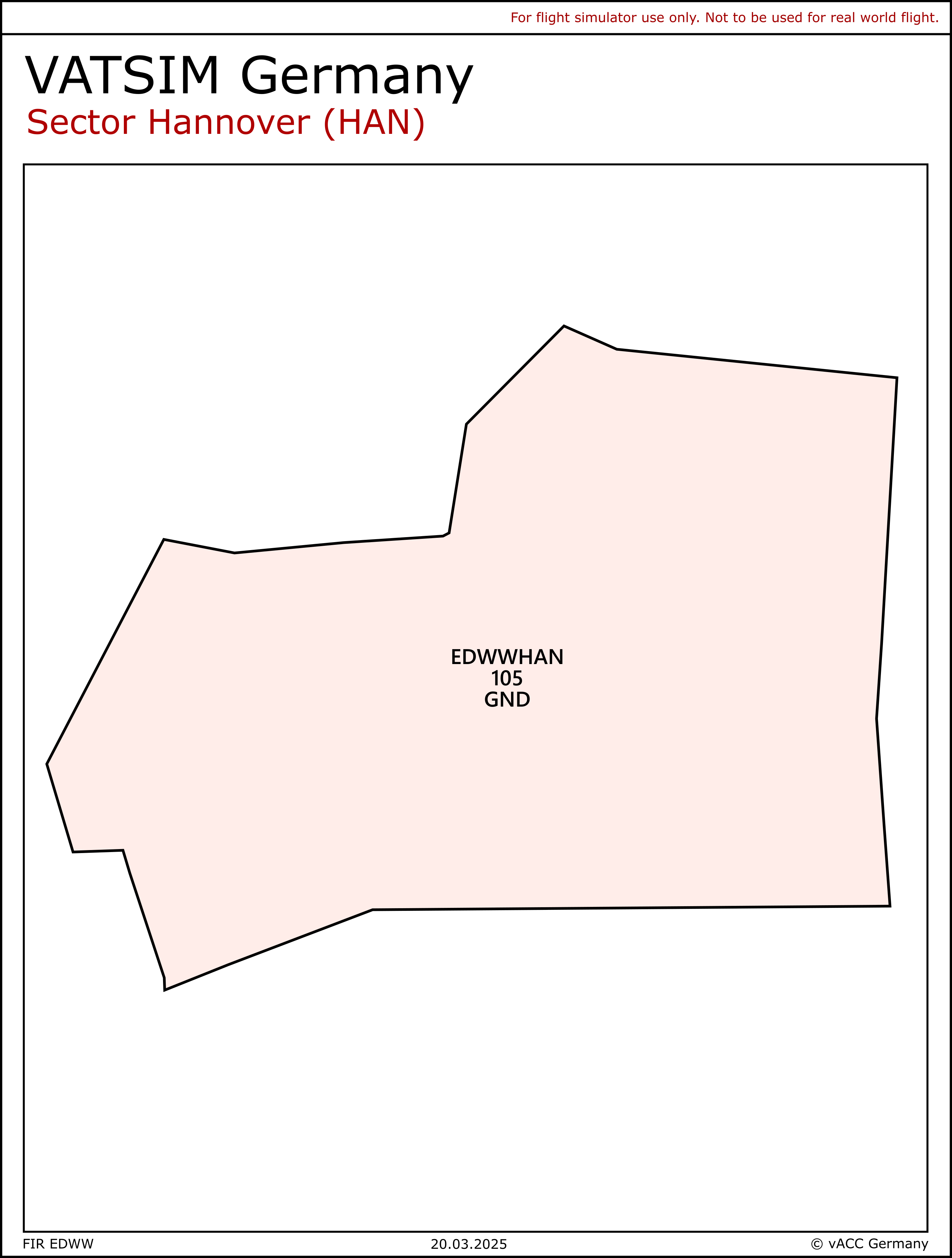](https://knowledgebase.vatsim-germany.org/uploads/images/gallery/2022-12/eddv-app-aor.jpg) **[Airspace](https://www.openflightmaps.org/ed-germany/ "openflightmaps.org"):** The airspace is divided into class D and C airspace. Airspace D reaches from 2500ft to FL65 in the inner ring, and the outer ring reaches from 4500ft to FL65. Above these two segments cover airspace C up to FL100. [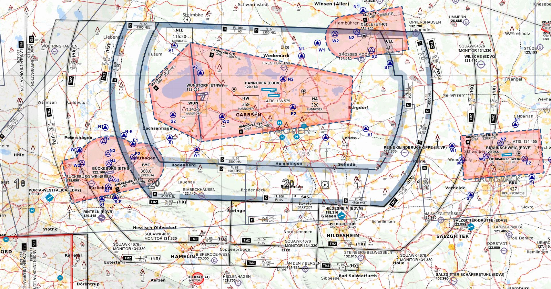](https://knowledgebase.vatsim-germany.org/uploads/images/gallery/2022-12/eddv-delta-charlie-airspace.jpg)*Charlie + Delta + TMZ Airspace of Hannover Airport and Wunstorf - © [openflightmaps.org](https://www.openflightmaps.org/)* There is also a **TMZ** with HX zones. The main part south of SAS/DLE is always active. The west area is active when runway 09 is in use. The east TMZ area is active when runway 27 is active. The size of the airspace (including) TMZ allows descends in protected airspace. **Minimum Vector Altitude:** The minimum vector altitude can be displayed in the DFS Pack with *Alt + M.* The south of Hannover has MVA areas which do not allow early descents on low altitudes (e.g. 3500ft). Always comply with restrictions given by the MVA. ### Arrivals **Normal Procedures:** In normal traffic, headings are used for arriving traffic before reaching the initial approach fix. Early directs to DVxxx in coordination with adjacent Centers are possible as well. **Runway assignment:** Bremen Radar always assigns the arrival runway for each aircraft. All heavy aircraft shall land on runway 09L/27R. Light aircraft parking on one of the general aviation aprons is preferred on runway 09L/27R to keep their taxi time short and to relieve the terminal area, for operational reasons runway 09R/27L can be used. All other aircraft can state their preference. In high-traffic situations, the workload on each runway shall be equal. **Approach Types:** Hannover offers different approach types for arriving traffic. All runways are equipped with ILS and authorized for RNP approaches. On runway 09L/27R CAT II/CAT III can be performed. In direction 27 ILS-Z and ILS-Y are available. They only differ in their intercept altitude, the standard is ILS-Z with an intercept altitude of 3000 ft.The ILS-Z and ILS-Y can only be used by aircraft with RNAV-1 equipment. Traffic unable for RNAV-1 shall only be cleared via the ILS-X due to the design of the missed approach.
**SRA:** At EDDV, surveillance radar approaches may be offered on the pilot's request. Check the following tables for the temperature-corrected approach altitudes ([Phraseology SRA](https://knowledgebase.vatsim-germany.org/link/1363#bkmrk-anfluganweisungen-sr)).| Temperatur | 10 °C or more | 9 °C to 0 °C | -1 °C to -10 °C | -11 °C to -20 °C | -21 °C to -30 °C |
| **OCA (CAT A-D)** | 770 | 800 | 820 | 840 | 860 |
| **10 NM** | 3300 | 3400 | 3500 | 3600 | 3700 |
| **9 NM** | 3000 | 3100 | 3100 | 3200 | 3300 |
| **8 NM** | 2700 | 2700 | 2800 | 2900 | 3000 |
| **7 NM** | 2400 | 2400 | 2500 | 2600 | 2600 |
| **6 NM** | 2000 | 2100 | 2200 | 2200 | 2300 |
| **5 NM** | 1700 | 1800 | 1800 | 1900 | 2000 |
| **4 NM** | 1400 | 1500 | 1500 | 1600 | 1600 |
| **3 NM** | 1100 | 1200 | 1200 | 1200 | 1300 |
| **2,0 NM** | 800 | 800 | 820 | 840 | 860 |
| **1,5 NM** | 630 | 640 | 660 | 680 | 690 |
| **1,0 NM** | 480 | 490 | 500 | 510 | 520 |
| **0,5 NM** | 320 | 330 | 330 | 340 | 340 |
| Temperatur | 10 °C or more | 9 °C to 0 °C | -1 °C to -10 °C | -11 °C to -20 °C | -21 °C to -30 °C |
| **OCA (CAT A-D)** | 770 | 800 | 820 | 840 | 860 |
| **10 NM** | 3300 | 3400 | 3500 | 3600 | 3700 |
| **9 NM** | 300 | 3100 | 3200 | 3300 | 3300 |
| **8 NM** | 2700 | 2700 | 2800 | 2900 | 3000 |
| **7 NM** | 2400 | 2400 | 2500 | 2600 | 2700 |
| **6 NM** | 2100 | 2100 | 2200 | 2200 | 2300 |
| **5 NM** | 1700 | 1800 | 1900 | 1900 | 2000 |
| **4 NM** | 1400 | 1500 | 1500 | 1600 | 1600 |
| **3 NM** | 1100 | 1200 | 1200 | 1200 | 1300 |
| **2,0 NM** | 790 | 810 | 830 | 850 | 8700 |
| **1,5 NM** | 630 | 650 | 670 | 680 | 700 |
| **1,0 NM** | 480 | 490 | 500 | 510 | 520 |
| **0,5 NM** | 330 | 330 | 340 | 350 | 350 |
| Temperatur | 10 °C or more | 9 °C to 0 °C | -1 °C to -10 °C | -11 °C to -20 °C | -21 °C to -30 °C |
| **OCA (CAT A-D)** | 850 | 870 | 890 | 910 | 940 |
| **10 NM** | 3300 | 3400 | 3500 | 3600 | 3700 |
| **9 NM** | 3000 | 3100 | 3200 | 3300 | 3400 |
| **8 NM** | 2700 | 2800 | 2800 | 2900 | 3000 |
| **7 NM** | 2400 | 2400 | 2500 | 2600 | 2700 |
| **6 NM** | 2100 | 2100 | 2200 | 2200 | 2300 |
| **5 NM** | 1800 | 1800 | 1900 | 1900 | 2000 |
| **4 NM** | 1400 | 1500 | 1500 | 1600 | 1600 |
| **3 NM** | 1100 | 1200 | 1200 | 1200 | 1300 |
| **2,0 NM** | 790 | 810 | 830 | 8660 | 880 |
| **1,5 NM** | 640 | 660 | 670 | 690 | 700 |
| **1,0 NM** | 490 | 500 | 510 | 520 | 530 |
| **0,5 NM** | 340 | 340 | 350 | 350 | 360 |
| Temperatur | 10 °C or more | 9 °C to 0 °C | -1 °C to -10 °C | -11 °C to -20 °C | -21 °C to -30 °C |
| **OCA (CAT A-D)** | 770 | 800 | 820 | 840 | 860 |
| **10 NM** | 3300 | 3400 | 3500 | 3600 | 3700 |
| **9 NM** | 3000 | 3100 | 3200 | 3200 | 3300 |
| **8 NM** | 2700 | 2700 | 2800 | 2900 | 3000 |
| **7 NM** | 2400 | 2400 | 2500 | 2600 | 2600 |
| **6 NM** | 2000 | 2100 | 2200 | 2200 | 2300 |
| **5 NM** | 1700 | 1800 | 1800 | 1900 | 2000 |
| **4 NM** | 1400 | 1500 | 1500 | 1600 | 1600 |
| **3 NM** | 1100 | 1200 | 1200 | 1200 | 1300 |
| **2,0 NM** | 780 | 800 | 820 | 850 | 870 |
| **1,5 NM** | 630 | 650 | 660 | 680 | 690 |
| **1,0 NM** | 480 | 490 | 500 | 510 | 520 |
| **0,5 NM** | 330 | 330 | 340 | 340 | 350 |
| **Waypoint** | **27L and 27R** | **09R and 09L** |
|---|---|---|
| **NIE** | R | L |
| **CEL** | R | L |
| **ROBEG** | R | L |
| **SAS** | R | L |
| **Waypoint** | **27L and 27R** | **09R and 09L** |
|---|---|---|
| **GITEX** | X | Z |
| **HLZ** | X or P | Z or R |
| **WERRA** | X | Z |
| **WRB** | X or P | Z or R |
All STARs (except HLZ and WRB P/R) require RNAV-1 equipment. Traffic unable for RNAV-1 shall be guided via radar vectors.
### Departures All departures on published procedures have an initial climb of 4000ft. In Hannover, all SID departures must contact Bremen Radar immediately when airborne without any further handoff. With the upper limit of FL105, all departures shall be transferred to Center climbing to FL100. ### Critical Areas The procedure design can cause critical situations between arrivals and departures. Areas with a higher risk of approximations between arrivals (blue) and departures (green) are marked red.| [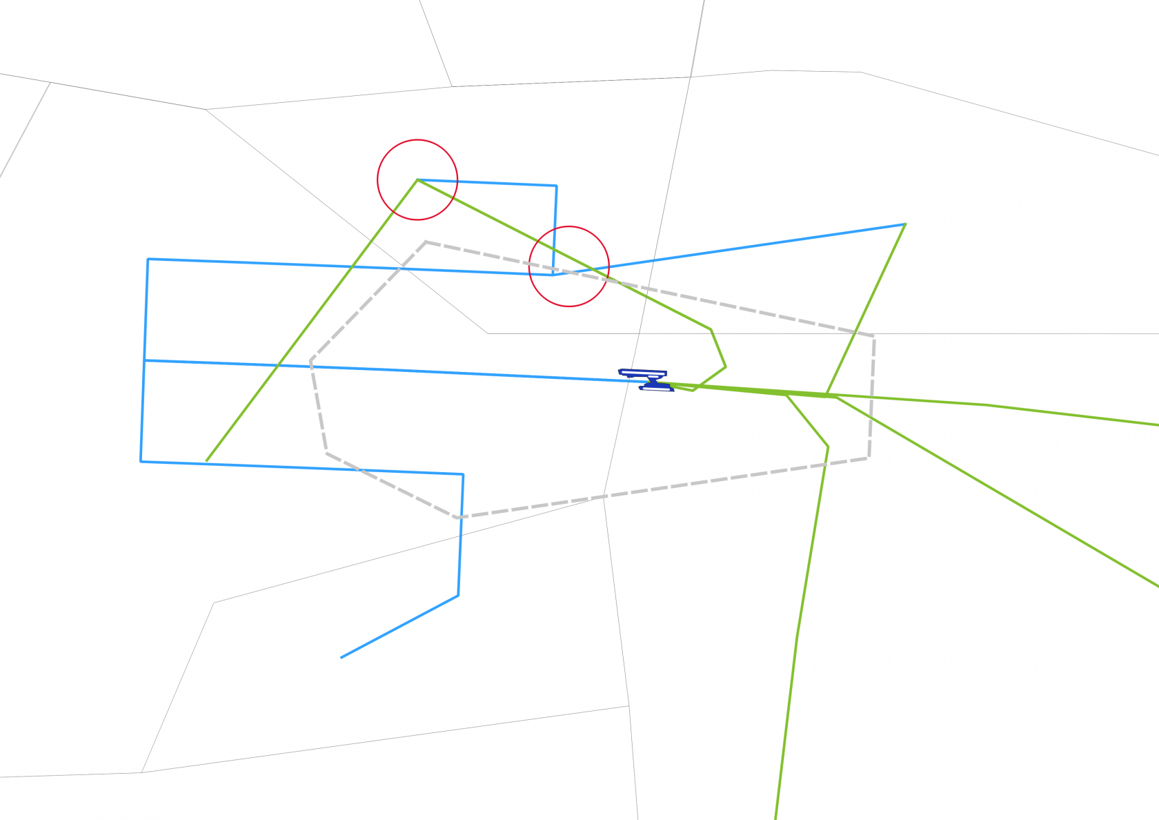](https://knowledgebase.vatsim-germany.org/uploads/images/gallery/2022-09/qwngrafik.png) | [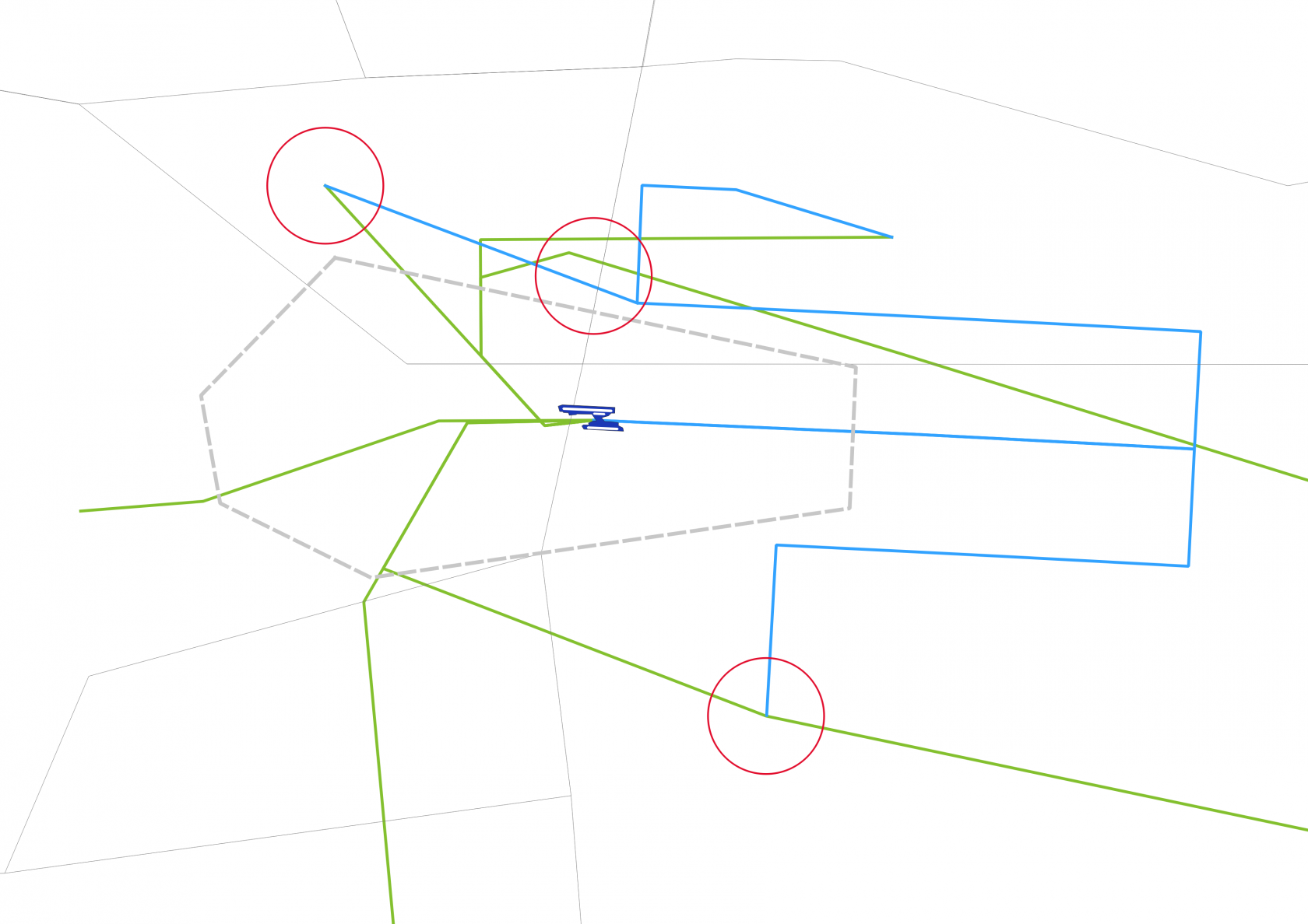](https://knowledgebase.vatsim-germany.org/uploads/images/gallery/2022-09/IJAgrafik.png) |
| *critical areas 09 operations Dep: VAXEV + NIE* | *critical areas 27 operations Dep: NIE + CEL + MULDO + POVEL* |
Every military Tower or Radar station shall inform sector HAN about the opening and closure of each AoR. Within the AoRs, full ATS shall be delegated from Bremen Radar to the military ATC.
Bremen Radar shall maintain half-described radar separation (500ft, 1.5 NM) to all military AoRs. In general, the military AoRs are designed in such a way that they won't conflict with EDDV arrivals and departures in most cases. For runway 09 at EDDV, traffic may need to maintain 4000ft or 5000 ft slightly longer than usual.
**Before staffing this airport for the first time:** Obtain a successful grade at the self-enrollment Moodle course: **[EDDW - Bremen Tower](https://moodle.vatsim-germany.org/course/view.php?id=76).**
### Bremen ATC Stations| **Station** | **Station ID** | **Login** | **Frequency** | **Remark** |
| **ATIS** | ADW | EDDW\_ATIS | 132.380 | -- |
| **Ground** | DWG | EDDW\_GND | 121.755 | -- |
| **Tower** | DWT | EDDW\_TWR | 120.330 | -- |
| **Sector Friesland** | FRI | EDDW\_APP | 124.800 | -- |
| **Departures/hour** | **Arrivals/hour** | **Global/hour** |
| 18 | 18 | 30 |
Datalink Clearances (DCL/PDC) are not available at EDDW.
During 27-Ops, Bremen Ground shall use the Z-SIDs by default (where available). All L-SIDs shall only be used on explicit pilot's request only. The initial climb for all departure routes is 4000 ft.
**The use of SOFED departure routes shall be terminated in case ED-R 202A, ED-R 202B or ED-R 202E (known as TRA Weser) are active.** **In this case, traffic via SOFED shall be re-routed via OKWEL N125 ITMIZ (then flight-planned route).** EDWW sector FRI will inform Bremen Ground about the activation and deactivation of TRA Weser. By default, ED-R 202 is to be considered as deactivated.
#### Special Procedure - SOFED SIDs Beginning on March 20, 2025, the SOFED SIDs are no longer connected to airway N125 due to changes to the ATS routes. Nevertheless, SOFED SIDs will still be used for departures to the west. Traffic intending to use SOFED SIDs is requested to file "ABDIM DCT ITMIZ N125 ..." as the initial segment of the F-Plan route. Traffic will then be instructed to follow a SOFED SID and to then join ITMIZ when reaching ABDIM located on the SID. [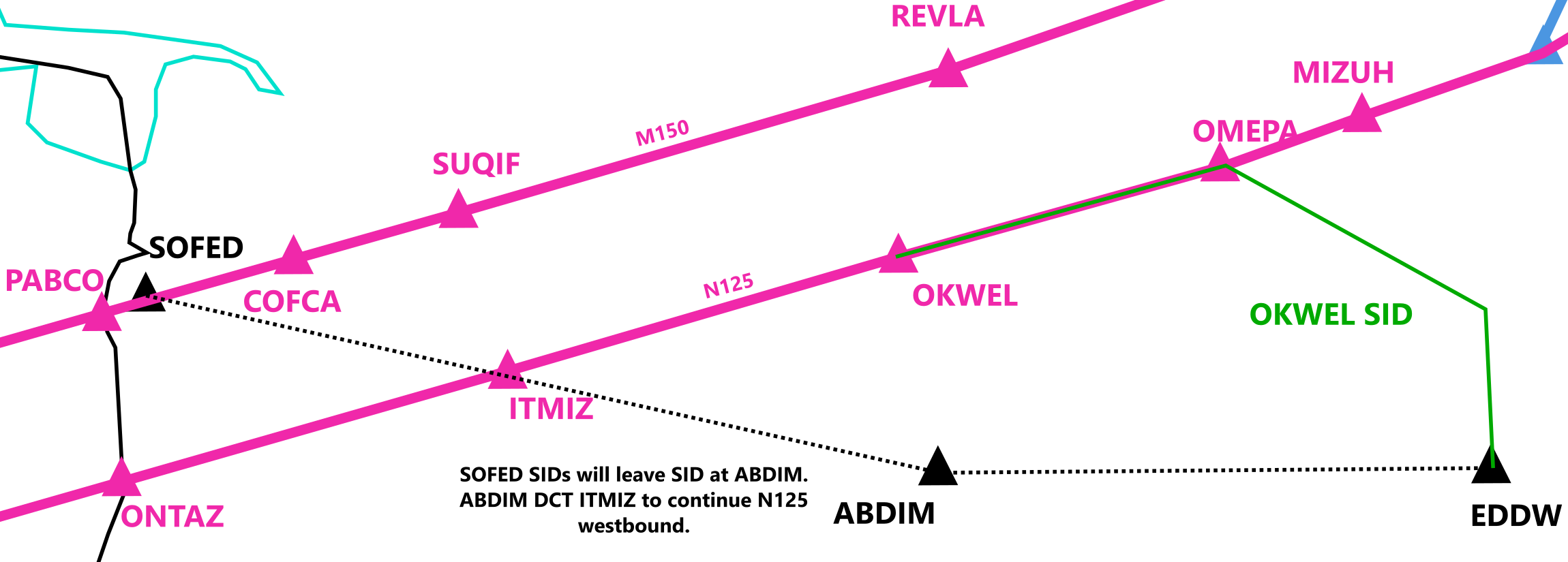](https://knowledgebase.vatsim-germany.org/uploads/images/gallery/2025-03/inkscape-owgoufmqnj.png)To avoid confusion, Bremen Ground is requested to inform the pilot about this procedure when giving IFR clearance: "... via SOFED2M departure, after ABDIM direct ITMIZ flight planned route ...". It is important to have a closer look at the F-Plan before giving IFR clearance to aircraft requesting to use SOFED SIDs.
It is to be expected that some pilots will file flight plans with the first waypoint "SOFED" instead of "ABDIM". This will still be considered as valid and Bremen Ground may clear SOFED SIDs nonetheless. In this case no coordination with Bremen Radar is required. #### Vectored Departures and Local IFR Vectored departures and local IFR are subject to individual coordination with the station responsible for EDWW sector FRI (Friesland). This sector will inform Bremen Ground about the planned departure routing. #### VFR traffic Departing VFR traffic will call Bremen Ground initially. Bremen Ground shall create an F-Plan when necessary and inform Bremen Tower about the intentions of the VFR traffic.**Runway 23 shall only be used on the explicit pilot's request and only for VFR departures of up to 5700 kg MTOM requesting to leave the CTR via SIERRA, WHISKEY, or NOVEMBER.**
**Jet aircraft or any aircraft with an MTOM of more than 5700 kg shall follow a published IFR departure route under VFR conditions.** In this case, Bremen Ground shall coordinate the departure routing with Bremen Tower. Bremen Ground will then inform the pilot about the expected departure routing.
### Ground Movements #### Parking Positions Bremen Ground shall use the arrival stand planned by the Groundradar Plugin. On request by the pilot, this stand may be changed. All stands are limited to a maximum wingspan of 36 m. Stands 12A and 18A may be used by heavy aircraft (wingspan up to 52 m). General Aviation traffic shall be parked at the General Aviation Apron next to taxi lane R if the aircraft's wingspan is below 24 m. Larger General Aviation traffic shall park at stands 12-17. Apron 3 shall be used for traffic of company Atlas Air Service (ATL, callsign "Air Bremen"). Additionally, this apron may be assigned at the pilot's request only. #### Taxiway Intersections**As a general rule, departing IFR traffic shall be cleared to Intersection A (RWY 09) or Intersection F (RWY 27) by Bremen Ground.** Intersection C (RWY 09) or D/E (RWY 27) may be used on the pilot's request only. **For noise abatement reasons, pilots of propeller and turbo-prop aeroplanes of more than 2000 kg MTOM will, as a rule, be cleared by Bremen Ground to use intersection E for take-off RWY 27 instead of intersection F.** The pilot shall inform Bremen ground in case intersection F is required due to performance reasons.
Departing VFR traffic using runway 23 shall be cleared to intersection D holding at the holding point of runway 27. Unless otherwise requested, departing VFR traffic from runway 09 shall use intersection C. VFR traffic departing from runway 27 shall be guided via intersection D.**VFR traffic requesting to depart from runway 09 to leave the CTR via WHISKEY shall be guided to runway intersection A only.** The use of other intersections is prohibited!
Whenever possible, departing traffic should be transferred to Bremen Tower when joining taxiway F.**For noise abatement reasons, taxi clearances for aircraft taxiing via intersection F to take off from RWY 27 will be issued only up to the CAT II/III holding position.**
#### Taxiway Restrictions| **TAXIWAYS** | **RESTRICTIONS** | **NOTES** |
| **K** | Max. wingspan < 24 m | --- |
| **L** | Max. Wingspan < 31 m | --- |
| **H, D, E, S** | Max. wingspan < 36 m | --- |
| **G** | Max. wingspan < 52 m | Between TWY C and position 12 inclusively |
| **N** | Max. Wingspan < 52 m | --- |
| **R** | Max. ICAO code letter B | Max. wingspan < 24 m |
| **F1, F2** | Use only permitted for Airbus factory traffic | Callsign BGA |
| **Max Spannweite** | **A/C Types** |
| < 30m | AT72 / CRJX / DH8D / RJ1H / etc. |
| < 36m | B739 / A321 / BCS3 / E195 / etc. |
| < 52m | B753 / B763 / A306 / etc. |
| < 65m | A333 / A346 / A35K / B744 / B77W / B78X / etc. |
| < 80m | A124 / A388 / B748 / etc. |
| > 80m | A225 |
| Movements | Beluga (A3ST) | Beluga XL (A337) |
| Departure from RWY 09 | Taxi via F, C, N and A | Taxi via F to intersection C, backtrack required |
| Departure from RWY 27 | Taxi via F | |
| Arrival from RWY 09 | ||
| Arrival from RWY 27 | Taxi via A, N, C and F | Backtrack required, taxi via C and F |
The Beluga XL requires a backtrack from intersection C, as this aircraft exceeds the wingspan limit at taxiway N.
#### Low Visibility Procedures When low visibility conditions exist, Bremen Ground shall only use Intersection A (RWY 09) and Intersection F (RWY 27) for departing traffic. This traffic is to be cleared to the CAT II/III holding points only. ### Helicopter Traffic At Bremen airport, the rescue helicopter "Christoph Weser" (Christoph 55, CHX55) is stationed. Departure and arrival are performed on the takeoff and landing platform "Yankee" between taxiways H, C and F.As a general rule, rescue helicopters will contact Bremen Tower directly. Bremen Tower shall inform Bremen Ground about any helicopter arrival or departure. **The use of the taxiways triangle F-C-H is prohibited during every takeoff and landing at Yankee!**
# Tower Bremen Tower is responsible for all movements on the runways and traffic flying inside the Bremen CTR. ### Control Zone [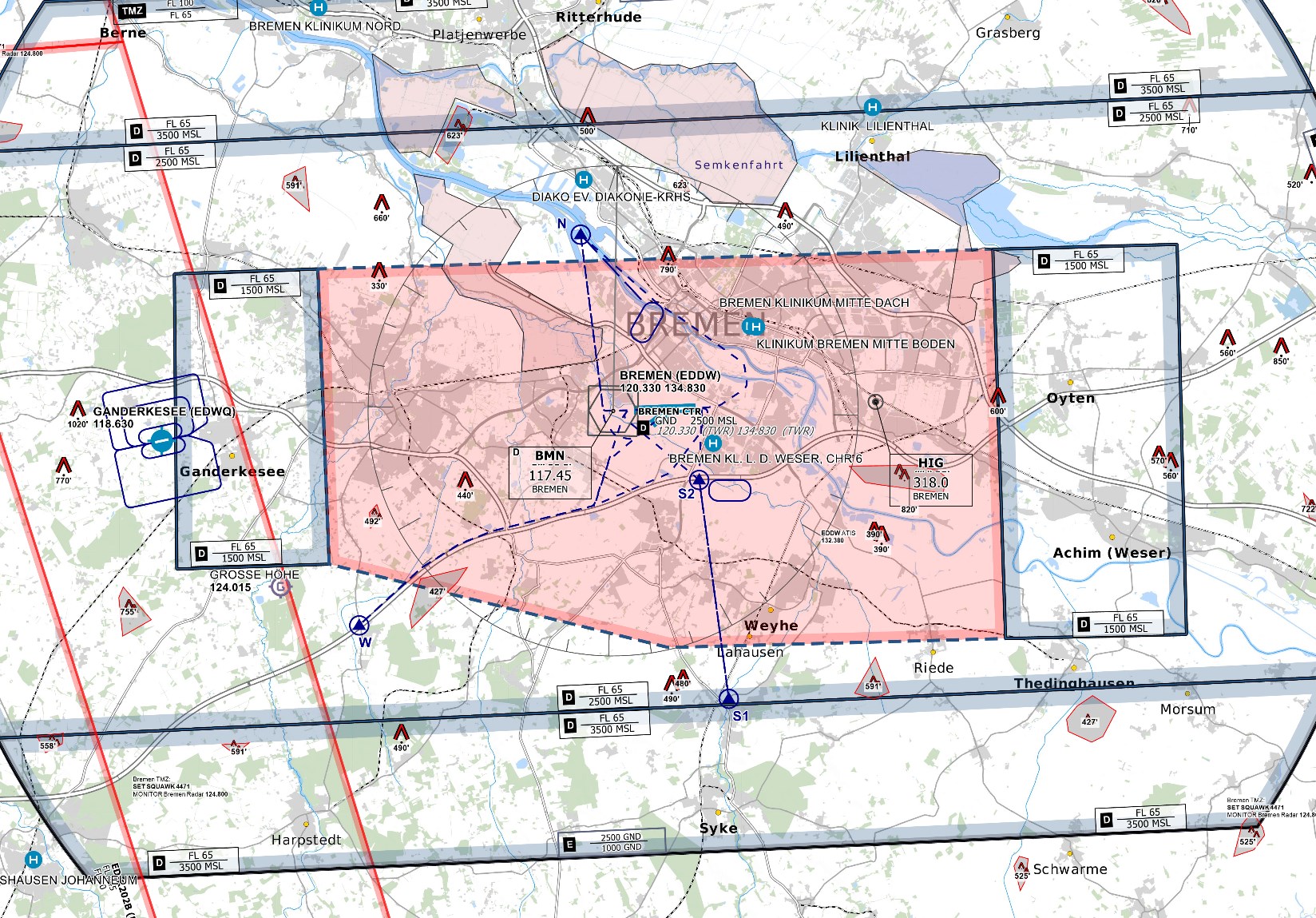](https://knowledgebase.vatsim-germany.org/uploads/images/gallery/2022-10/eddw-ctr.png) Bremen CTR reaches from the ground to an altitude of 2500 ft MSL. Bremen Radar (sector Friesland) is responsible for movements inside Bremen airspace class D (non-CTR). ### Runways Runway 09/27 is the only available runway for IFR and landing VFR traffic. The runway direction shall be based on the current wind situation at the aerodrome. #### Runway 23 Runway 23 can be used during the daytime and if the wind conditions permit. This runway shall only be used on the explicit pilot's request and only for VFR departures of up to 5700 kg MTOM requesting to leave the CTR via SIERRA, WHISKEY, or NOVEMBER. #### Beluga Special Runway Both runway thresholds are connected to runway extensions increasing the TORA by roughly 300 m. These paved RWY extensions in front of the respective thresholds shall only be used as special take-off runways for Beluga and Beluga XL aircraft (A3ST and A337). ### Reduced Runway Separation (RRS) Bremen Airport (EDDW) is approved to apply the following reduced runway separation minima during day only:| **Runway** | CAT 1 following a departing CAT 1 or 2 | CAT 2 following a departing CAT 1 or 2 | CAT 1 to 3 following a departing CAT 3 |
| RWY 09/27 | 600 m | 1500 m | --- |
**The Beluga XL (A337) requires a backtrack from intersection C to depart from RWY 09 as this aircraft exceeds the wingspan limit at taxiway N.**
#### Departure Releases Departures do not have to be released by EDWW (Bremen Radar) unless: - EDWW explicitly restricts departures by time, SID or until further notice - Departures out of the non-operational runway config - The first departure after a runway change - The first departure after an unplanned missed approach ### Arriving Traffic After landing, Bremen Tower shall issue the initial taxi clearance via F (RWY 09) or A (RWY 27) and transfer the aircraft to Bremen Ground.For jet aircraft with an MTOM of more than 20 t, landing on runway 27, Bremen Tower shall instruct the pilot to vacate via taxiway A before issuing the landing clearance. **After coordination with Bremen Ground, this traffic may also be approved to vacate via C.**
Traffic landing on runway 09 with a wingspan of more than 36 m shall be instructed to vacate the runway via taxiway F before issuing the landing clearance.**The Beluga XL (A337) requires a backtrack from RWY 27 to leave via taxiway C as this aircraft exceeds the wingspan limit at taxiway N.** The pilot shall be informed about these procedures before issuing the landing clearance. The backtrack is performed at the designated Beluga Special Runway.
### VFR Traffic Traffic requesting traffic circuit flights may preferably be cleared for the southern downwind due to noise-abatement reasons. Still, using the northern downwind is not prohibited per se. #### Departing VFR Traffic Departing VFR traffic will initially contact Bremen Ground. Bremen Ground will inform Bremen Tower about the intentions of the departing VFR traffic.**Generally, Runway 27 is the preferred runway for VFR departures. Runway 23 should be used on the explicit pilot's request only!**
Traffic requesting to depart from runway 09 to leave the CTR via WHISKEY shall only take off from runway intersection A.
**Departures from runway 23 to leave the CTR via NOVEMBER shall only initiate the right turn after departure, after explicit instruction from Bremen Tower.** Bremen Tower shall make sure that no conflict with arriving or departing traffic via runway 09/27 exists before issuing the right turn.
##### VFR departure for Jets and Aircraft with a MTOM of more than 5700 kg**Jet aircraft or any aircraft with an MTOM of more than 5700 kg shall follow a published IFR departure route under VFR conditions.** In this case, Bremen Ground shall coordinate the departure routing with Bremen Tower.
Despite Bremen Ground previously issuing the expected departure procedure to the pilot, Bremen Tower shall also instruct the departure procedure before takeoff clearance.
The departure routes may be issued for IFR traffic, except the following maximum altitudes after departure shall be used:| Maximum Altitude | RWY 09 | RWY 27 |
| Maximum 2000 ft or below | SOFED, WIMCI, NIE | OKWEL, NIE, GESTO, OTEXE, WSN, OKWEL |
| Maximum 1500 ft or below | OKWEL, GESTO, WSN | SOFED |
The departure routing shall be assigned depending on the requested or filed waypoint from the pilot. **If requested by the pilot, Bremen Tower may coordinate an entry into airspace class D (non-CTR) with Bremen Radar to enable a climb above the mentioned altitudes.**
#### Arriving VFR Traffic Arriving traffic shall be guided via the published CTR entry procedures.**Jet aircraft or any aircraft with an MTOM of more than 5700 kg shall only enter the CTR via a published IFR approach (e.g. ILS).** This traffic shall contact Bremen Radar to join the published approach. Bremen Tower will not provide vectoring service for such traffic.
#### Rescue Helicopter Traffic ##### Christoph 55 The rescue helicopter Christoph Weser (CHX55) is stationed at Bremen airport. It usually parks in front of the DRF hangar (Hangar K). Departures and arrivals will be performed via the takeoff and landing platform between taxiways H, C and F. **This platform shall only be used for rescue helicopter traffic.** The platform may also be called "Yankee" unofficially. [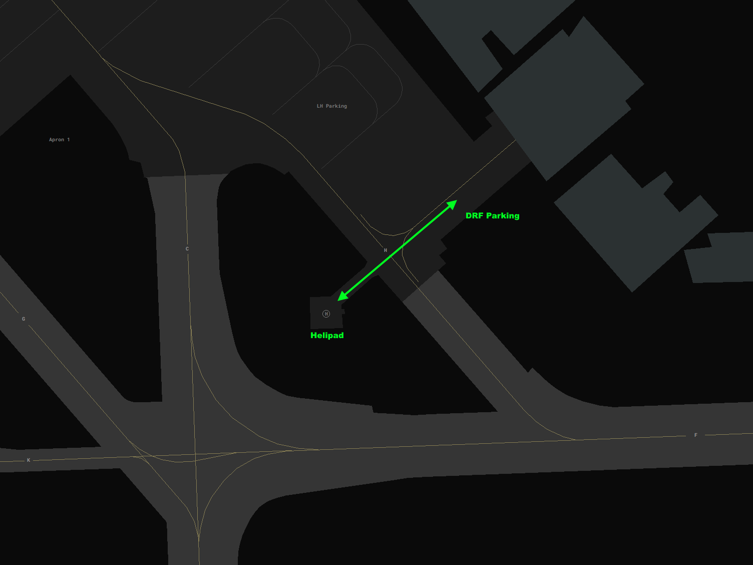](https://knowledgebase.vatsim-germany.org/uploads/images/gallery/2024-10/drf-helipad.png)**For departure, Bremen Tower will be contacted directly. In all cases, Bremen Tower shall inform Bremen Ground about any movement via the takeoff and landing platform** (arrivals and departures).
**It is important to note that the platform "Yankee" is not to be considered a helipad.** It functions as a takeoff and landing platform comparable to other hospitals in the CTR. **Therefore, no takeoff and landing clearance shall be given!** Traffic will depart and land at its own discretion.
**Examples:** > *"Christoph 55, cross Hotel, wind 100 degress 5 knots, takeoff Yankee own discretion, proceed direct \[...\]."* > > *"Christoph 55, wind 100 degress 5 knots, land Yankee own discretion, cross Hotel, approved to leave on ground."***The use of the taxiways triangle F-C-H is prohibited during every takeoff and landing at Yankee!**
##### Other Rescue Traffic Within Bremen CTR, three hospitals with helipads exist. Rescue helicopter Christoph 6 (CHX06) is stationed at "Klinikum Links der Weser" which may also be called "Pad Zulu" unofficially. Bremen Tower shall announce the current wind situation at EDDW whenever a rescue helicopter reports approaching the destination. A map with all hospitals can be toggled with ALT + H in the Euroscope package. [](https://knowledgebase.vatsim-germany.org/uploads/images/gallery/2024-10/euroscope-jk5etzeoir.png) ### Low Visibility Procedures (LVP) When the weather condition requires low visibility operations the use shall be announced in the ATIS. Additionally, Bremen Tower shall inform Bremen Ground and Bremen Radar about the beginning and termination of Low Visibility Procedures.use ***&lvp*** in the ATIS maker URL or "LOW VIS OPS" flag in the NOTAM menu of vATIS
**When low-visibility conditions exist, Bremen Tower shall instruct arriving traffic to vacate via taxiway F (RWY 09) or taxiway A (RWY 27) before issuing the landing clearance.** The use of intersection departures is prohibited during low-visibility operations.
# Arrival ## Sectorization and Airspace ### Sector Friesland [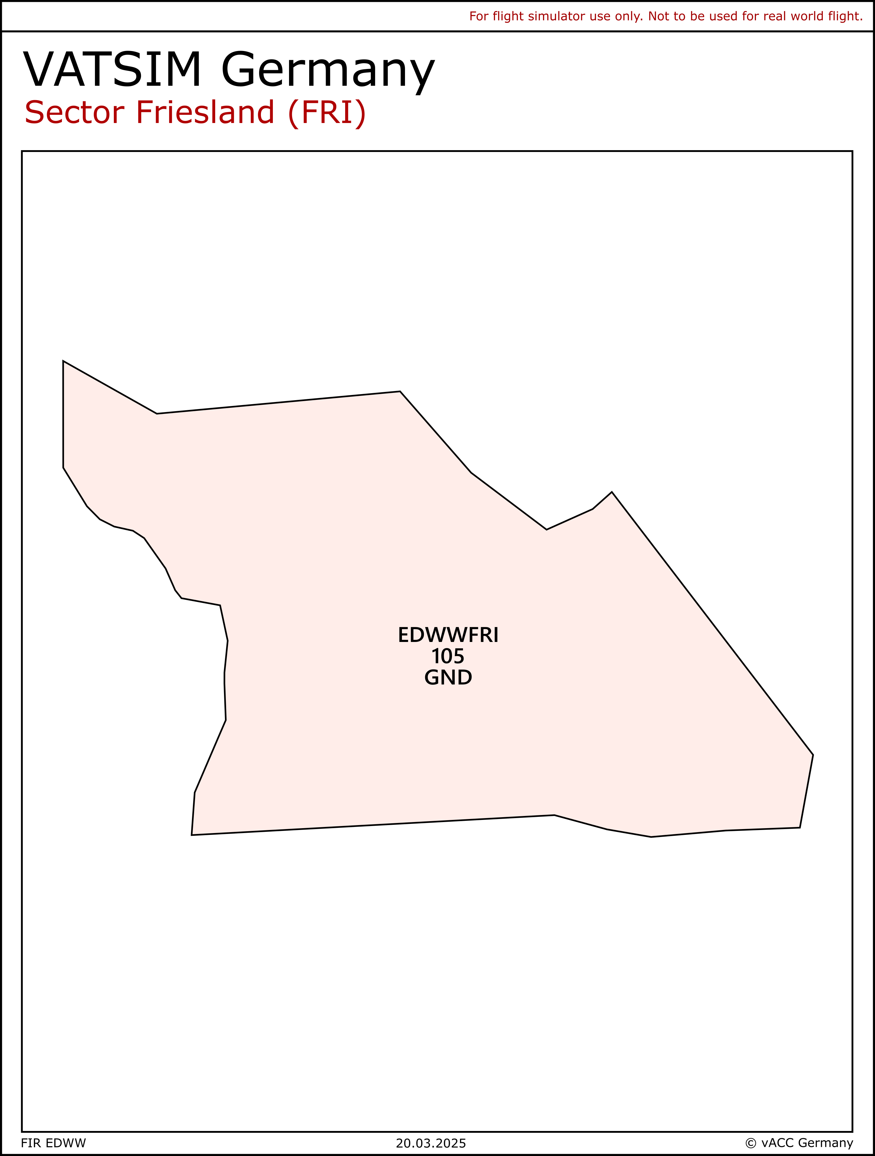](https://knowledgebase.vatsim-germany.org/uploads/images/gallery/2023-02/fri.png) Sector Friesland is part of EDWW sector group [Nord-B (EBG Nord-B)](https://knowledgebase.vatsim-germany.org/books/edww-bremen-radar/page/overview-ebg-nord-b).| **Station** | **Station ID** | **Frequency** | **Login** |
| Friesland | FRI | 124.800 | EDDW\_APP |
Note: Unless otherwise coordinated, traffic has to exactly proceed on the listed routes. Shortcuts through the TRA are not allowed.
Sector FRI shall inform Bremen Ground/Tower about the activity of TRA Weser. During the activity of ED-R 202A, 202B or 202E all SOFED departures shall not be used. Traffic shall be routed via OKWEL N125 ITMIZ instead.
[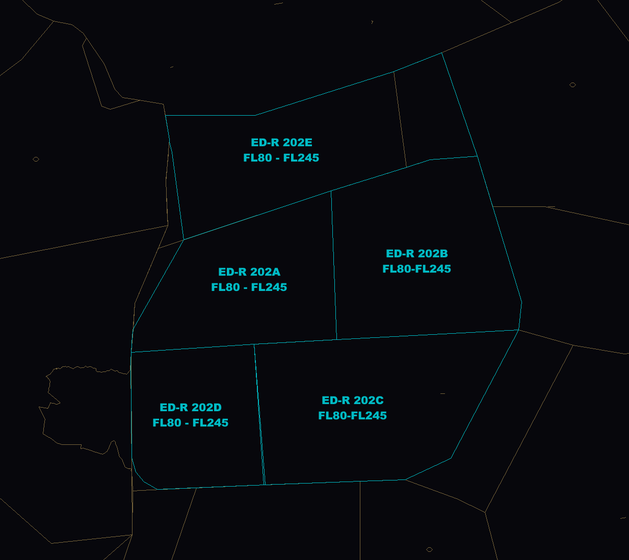](https://knowledgebase.vatsim-germany.org/uploads/images/gallery/2024-10/tra-wesrer.png) ### TRA Friesland Within the northern part of sector FRI, parts of TRA Friesland may be active from FL80-FL245. Traffic is generally not approved to cross ED-R 201A and ED-R201C. Traffic may cross ED-R 201B on the following priority routes (see box below):Note: Unless otherwise coordinated, traffic has to exactly proceed on the listed routes. Shortcuts through the TRA are not allowed.
| **Runway** | **Available Approach Types** | **Intercept Altitude** |
| 09/27 | ILS Z, LOC Z, RNP, VOR | 3000 ft |
| ILS Y | 1700 ft (as published) |
| **Conditions** | **Target Spacing** |
| Normal Operations | 6 NM (\*) |
| After coordination with Tower | 3 NM |
| During Low Visibility Conditions | 10 NM |
(\*) Behind a Beluga XL (A337) landing on runway 27, Bremen Radar shall increase the target spacing as a backtrack is required to vacate the runway via taxiway C due to wing span limitation. The normal Beluga (A3ST) is not affected from this.
## Departing Traffic from EDDW Departing traffic from EDDW shall automatically switch frequency from Tower to EDWW. Traffic transferred to EDWW ACC sectors according to [LOP EDWW](https://knowledgebase.vatsim-germany.org/books/bremen-fir-edww/page/lop-bremen-acc). Often traffic may be coordinated on a higher flight level with sector ALR, EID or EMS to avoid unnecessary level-offs. #### Special Procedure - SOFED SIDs Beginning on March 20, 2025, the SOFED SIDs are no longer connected to airway N125 due to changes to the ATS routes. Nevertheless, SOFED SIDs will still be used for departures to the west. Traffic intending to use SOFED SIDs is requested to file "ABDIM DCT ITMIZ N125 ..." as the initial segment of the F-Plan route. Traffic will then be instructed to follow a SOFED SID and to then join ITMIZ when reaching ABDIM located on the SID. [](https://knowledgebase.vatsim-germany.org/uploads/images/gallery/2025-03/inkscape-owgoufmqnj.png)It is to be expected that some pilots will file flight plans with the first waypoint "SOFED" instead of "ABDIM". This will still be considered as valid and Bremen Ground may clear SOFED SIDs nonetheless. Additionally, traffic may not follow the short cut to ITMIZ as instructed by Bremen Ground. It is highly recommended to coordinate shortcuts with sector Ems and Eider, especially when the route looks invalid.
## VFR Traffic ### VFR DeparturesJet aircraft or any aircraft with an MTOM of more than 5700 kg shall follow a published IFR departure route under VFR conditions.
By default, the Bremen Tower will instruct the aircraft to stay clear of airspace class D (non-CTR). Nevertheless, coordination may be required between Bremen Tower and Bremen Radar in case the pilots request further climb. In this case, Bremen Radar shall issue the approval to enter airspace D (non-CTR) to Bremen Tower directly. ### VFR ArrivalsJet aircraft or any aircraft with an MTOM of more than 5700 kg shall follow published IFR arrival routes under VFR conditions.
In this case, the arriving VFR traffic shall contact Bremen Radar latest 25 NM before approaching EDDW. Bremen Radar shall provide service for a practice approach VFR (e.g. via an ILS approach). An entry via published VFR arrival routes into the CTR is not possible. ## Emden (EDWE) Emden (EDWE) is an uncontrolled aerodrome located about 19 NM southwest of ETNT. Due to published IFR procedures, limited service has to be provided for IFR traffic: - Approach clearance - IFR clearance**When online, Wittmund Radar (ETNT\_APP) will take over all responsibilities for IFR traffic from/to Emden.** In this case, traffic shall be coordinated individually between Bremen Radar and Wittmund Radar. **Bremen Radar shall transfer arriving traffic early enough before reaching IAF for Wittmund Radar to clear the approach.**
### Approach Types There is one published approach type available at EDWE:| **Runway** | **Available Approach Types** | **IAF** | **Altitude at IAF** |
| 07/25 | **RNP Z** | **SUQIF** | **4000 ft** |
| RNP Y (HEL) | JUIST | 3000 ft |
**The RNP Y is only available for helicopter traffic.** This approach is primarily used by helicopter traffic approaching from oil rigs located in the North Sea during IMC. This approach shall only be cleared when requested by the helicopter pilot.
As traffic will leave controlled airspace during the approach, traffic must proceed via the published approach procedures only! Arriving traffic shall be instructed to switch to Emden Information or 122.800 before reaching FAF.
### Departing Traffic Departing traffic will request the IFR clearance on the ground. Traffic will depart at its discretion and shall be instructed to report when airborne. Departing traffic from EDWE shall be offered to switch frequency for taxi and departure to properly communicate with other (VFR) traffic at Emden. Departing traffic shall be transferred according to [LOP EDWW](https://knowledgebase.vatsim-germany.org/books/bremen-fir-edww/page/lop-bremen-acc).JUIST departures are only available for helicopter traffic. In general, traffic shall only depart via published departure procedures.
### Emden Block Clearance Area To keep sufficient distance from EHGG APP for traffic on the published approach procedure for runway 07 at EDWE, the airspace within the "Emden Block Clearance Area" is permanently delegated from Eelde Approach to Bremen Radar/Wittmund Radar: [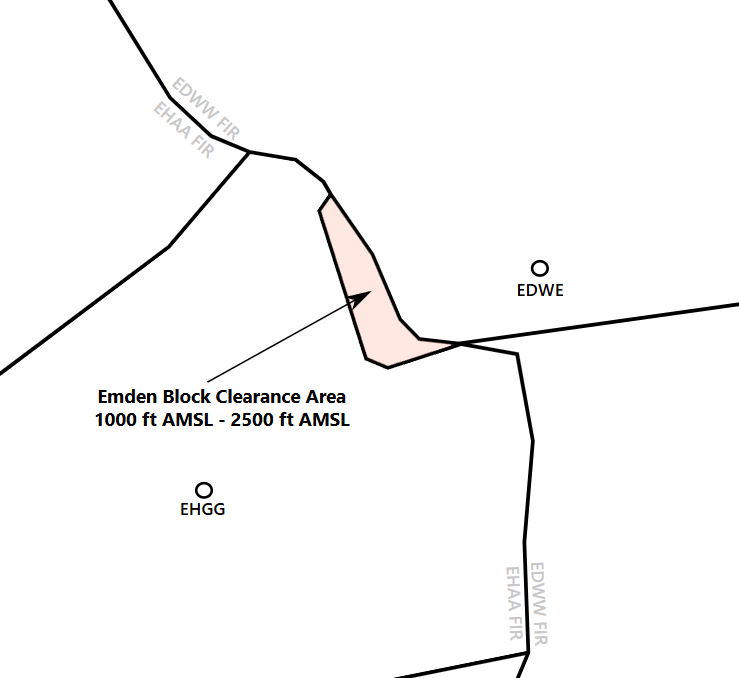](https://knowledgebase.vatsim-germany.org/uploads/images/gallery/2025-02/msedge-d9o3j30tuw.png) ## Wilhelmshaven (EDWI) Wilhelmshaven Jadeweser Airport (EDWI) is an uncontrolled aerodrome located about 14 NM southeast of ETNT. Due to published IFR procedures, limited service has to be provided for IFR traffic: - Approach clearance - IFR clearance**When online, Wittmund Radar (ETNT\_APP) will take over all responsibilities for IFR traffic from/to Wilhelmshaven.** In this case, traffic shall be coordinated individually between Bremen Radar and Wittmund Radar. **Bremen Radar shall transfer arriving traffic early enough before reaching IAF for Wittmund Radar to clear the approach.**
### Approach Types There is one published approach type available at EDWI:| **Runway** | **Available Approach Types** | **IAF** | **Altitude at IAF** |
| 02/20 | RNP | REVLA | 4000 ft |
As traffic will leave controlled airspace during the approach, traffic must proceed via the published approach procedures only! Arriving traffic shall be instructed to switch to Wilhelmshaven Information or 122.800 before reaching FAF.
### Departing Traffic Departing traffic will request the IFR clearance on the ground. Traffic will depart at its discretion and shall be instructed to report when airborne. Departing traffic from EDWI shall be offered to switch frequency for taxi and departures to properly communicate with other (VFR) traffic at Wilhelmshaven. Departing traffic shall be transferred according to [LOP EDWW](https://knowledgebase.vatsim-germany.org/books/bremen-fir-edww/page/lop-bremen-acc). ## Groningen (EHGG) IFR traffic may approach EHGG via sector Friesland. Inbound traffic shall be transferred at FL70 to EHGG APP. Outbound traffic from EHGG will be cleared to FL60 from EHGG APP. # EDAH - Heringsdorf Airport # General**Before staffing this airport for the first time:** Obtain a successful grade at the self enrollment Moodle course: **[EDAH - Heringsdorf Tower](https://moodle.vatsim-germany.org/course/view.php?id=70)**.
#### Heringsdorf ATC Stations| **Station** | **Station ID** | **Login** | **Frequency** | **Remark** |
| **ATIS** | - | - | - | not available |
| **Tower** | AHT | EDAH\_TWR | 132.830 | Callsign: Heringsdorf Tower |
| **Center** | MRZ | EDWW\_MRZ\_CTR | 124.175 | -- |
| **Name** | Heringsdorf |
| **ICAO** | EDAH |
| **IATA** | HDF |
| **Runway** | Total |
| **10** | 2305 x 35 |
| **28** |
| **ID** | **Name** | **Type** | **Frequency** |
| FLD | Friedland | DVOR/DME | 117.15 MHz |
| TRT | Trent | DVOR/DME | 108.45 MHz |
| Runway | ID | Type | Frequency | Course | Glide Path | Category |
| 28 | - | - | - | - | - | - |
| **Runway** | **ILS** | **LOC** | **RNP** | **VOR** | **NDB** |
| 10 | **✔** | ||||
| 28 | **✔** |
| **Waypoint** | **Min. LVL** | **Max. LVL** | **Inbound Course** | **Direction of Turns** |
| UDAXI | 3500 FT | UNL | 004° | Left |
| **ID** | **Position** | **Callsign** | **Frequency** | **Responsibilities** |
| AHT | EDAH\_TWR | Heringsdorf Tower | 132.830 | EDAH CTR |
| MRZ | EDWW\_MRZ\_CTR | Bremen Radar | 124.175 | Müritz Sector |
| **Runway** | **Takeoff Minima** | **Condition** |
| 10/28 | 400 m RVR | During Day |
| 800 m RVR | During Night |
All departing IFR flights require a release before issuing the takeoff clearance!
Departing IFR traffic will switch to Bremen Radar automatically when passing 500 ft. #### Arrivals Arrivals may leave the runway on taxiways according to taxiway restrictions. When runway 10 is in-use. Heringsdorf Tower shall issue aircraft to vacate via D and cross runway 28 via B. Avoid congestion at taxiway B. #### Go Arounds Go arounds shall be flown as published and shall be coordinated with Bremen Radar immediately before the transfer of communications. #### Stand Assignments On the main apron, there are 2 parking positions available for ICAO code letter C aircraft (max. wingspan 36 m). Aircraft larger than category C will occupy both stands. Small GA aircraft (wheelbase >11 m) may park on the aprons or grass surface along taxiway C. Heringsdorf Tower may inform Bremen Radar in advance when no parking space is available for arriving traffic. #### Restrictions - TWY A, D: width 18 m - TWY C: width 11 m - TWY E, F: width 10 m, max. weight 5.7 t - Grass runways: only for VFR traffic and during day time Departing traffic runway 28 which is unable to use taxiway C shall taxiway via B and D with runway crossing. Same applies to arriving traffic from runway 10. Departing traffic runway 10 shall use taxiway A. If only taxiway B can be used, a backtrack is necessary. [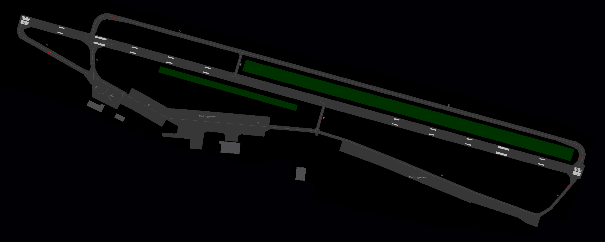](https://knowledgebase.vatsim-germany.org/uploads/images/gallery/2023-11/euroscope-5yyvakjbur.png) #### A-CDM Not available. #### DCL Clearance Not available. ### VFR Traffic VFR traffic may leave/enter the CTR along the published mandatory reporting points: - November, Whiskey, Sierra, Echo Heringsdorf Tower will not control any traffic regarding the Mellenthin glider strip and glider area. ### Low Visibility Procedures (LVP) At Heringsdorf, no approaches are possible when low visibility conditions exist. Departures are allowed to take off if the following minima are met:| **Runway** | **Takeoff Minima** | **Condition** |
| 10/28 | 400 m RVR | During Day |
| 800 m RVR | During Night |
This airport can be staffed by every controller with a S2 rating or higher. There are no Moodle exams required.
Hamburg Finkenwerder is the factory airport of the aircraft manufacturer Airbus. The traffic primarily consists of test flights of new aircraft, delivery flights and individual cargo flights with Airbus' own cargo aircraft (Belugas). ### ATC Stations| **Station** | **Station ID** | **Login** | **Frequency** | **Remark** |
| **ATIS** | AHI | EDHI\_ATIS | 135.965 | -- |
| **Tower** | HIT | EDHI\_TWR | 123.255 | -- |
| **Hamburg East** | HAM | EDDH\_APP | 120.540 | -- |
| **Hamburg West** | HAMW | EDDH\_W\_APP | 134.255 | -- |
| **Arrival** | DHAT | EDDH\_F\_APP | 118.205 | -- |
Finkenwerder Tower shall inform Hamburg Tower and Bremen Radar (sector HAM) about the runway-in-use at EDHI immediately.
Runway 05/23 is equipped with three turning pads, two at the threshold of RWY 05 and one at the threshold of RWY 23. These turning pads can be used for backtracks after landing or for line-up. Alternatively, traffic with an MTOW of 20 t or less may perform a 180-degree turn on the runway directly.Traffic with an MTOW of more than 20 t shall use the turning pads for 180 degrees only!
### Aprons and Taxiways #### Aprons There are multiple aprons available at Finkenwerder. Apron 1 will primarily used to park aircraft which are ready for delivery to the customer as the Airbus Delivery Center is right next to this apron. Apron 1 is only available to aircraft with a maximum wingspan of 36 m. Apron 2 is the primary apron for the Airbus production. Stands with an L (left), R (right) or N (north) designator can only be used for aircraft with a wingspan of up to 36 m. Widebody aircraft will be parked on parking positions 201, 202, 203, 204, 205, 247, 248 and in front of some hangars. Apron 3 is also used for the aircraft production. Beluga transport traffic will park in front of hangar 82, position 382. #### Taxiways All orange and blue taxi guidance lines may be used for aircraft with a maximum wingspan of 36 m only. Orange and blue taxi lines can be used simultaneously. Additionally, the following taxiway restrictions apply: - All taxiways on Apron 1 can only be used by aircraft with a maximum wingspan of 36 m - All taxiways on Apron 2 (I, K, M) can only be used by aircraft with a maximum wingspan of 80 m - Taxiway K can only be used by aircraft with a maximum wingspan of 52 m. ### IFR Clearance Finkenwerder shall issue the IFR clearance to departing IFR traffic on the ground. The following departure routes are available: [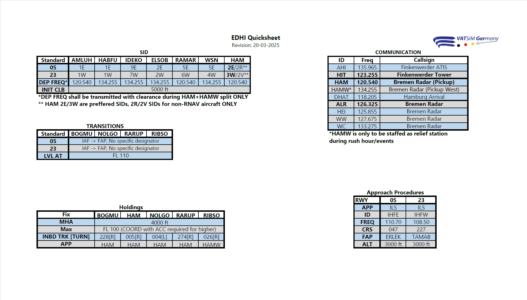](https://dms.vatsim-germany.org/s/dybC5Wqm5pP4ZcJ) ### Working with two Departure Frequencies In case both of the approach stations (HAM + HAMW) are online, Finkenwerder Tower shall add the correct departure frequency as information within the IFR clearance or at the end of the "readback correct" confirmation. This procedure does not need to be applied if only one approach station is online. > ***Readback correct. Departure frequency** \*when passing 2000ft\* **Bremen Radar 120.540 (134.255)*** **Departure Frequencies SIDs:** - To HAM (120.540): AMLUH, LUGEG, HAM, RAMAR - To HAMW (134.255): ELSOB, IDEKO, HABFU, WSNBremen Radar will inform Tower once this procedure needs to be applied.
### Departure Release**For every IFR departure, Finkenwerder Tower requires a departure release from Bremen Radar sector HAM. Bremen Radar will coordinate this traffic with Hamburg Tower. **
Departing traffic will switch to Bremen Radar automatically after take-off. Only on request, Finkenwerder Tower may inform the pilot about the departure frequency (see quicksheet). ### Arriving Traffic Bremen Radar will transfer aircraft to Finkenwerder Tower when established on the final. In case of a missed approach, Finkenwerder Tower shall inform Bremen Radar sector HAM immediately. Unless otherwise coordinated, this traffic will be transferred to frequency 120.540. ### VFR Traffic Finkenwerder Tower is only responsible for VFR traffic approaching/departing at EDHI. In other cases, this traffic shall be coordinated with Hamburg Tower individually. ### Low Visibility Operations During Low Visibility Operations at Finkenwerder, only runway 05 can be used for arriving traffic, as runway 05 is equipped with an ILS approach up to CAT II. Departing traffic may use both runway directions under the condition that the minimum takeoff RVR is met:| **Runway** | **Takeoff Minima** | **Condition** |
| 05 | 800 m RVR | --- |
| 23 | 125 m RVR | --- |
Note: It might become necessary to use Runway 05 for arriving traffic while using Runway 23 for departures. In this case, close coordination with Bremen Radar is required before issuing a line-up clearance.
# EDHL - Lübeck Airport # Overview**Before staffing this airport for the first time:** Obtain a successful grade at the self enrollment Moodle course: [**EDHL - Lübeck-Blankensee Tower**](https://moodle.vatsim-germany.org/course/view.php?id=71).
Lübeck Airport is located 8km south of Lübeck inside the Hamburg Metropolitan region. #### Lübeck ATC Stations| **Station** | **Station ID** | **Login** | **Frequency** | **Remark** |
| **ATIS** | AHL | EDHL\_ATIS | 119.930 | -- |
| **Ground** | HLG | EDHL\_GND | 121.780 | -- |
| **Tower** | HLT | EDHL\_TWR | 128.705 | -- |
| **Arrival** | HAM | EDDH\_APP | 120.540 | -- |
| **Runway** | **ILS CAT I** | **ILS CAT II** | **LOC** | **RNP** | **NDB** |
| 07 | **✔** | **✔** | **✔** | **✔** | |
| 25 | **✔** | **✔** | **✔** |
HAM 7J and HAM 7M shall be used for non-RNAV aircraft only. All other SIDs require RNAV equipment.
### Specials **Vectored departures:** The use of vectored departures requires prior coordination with the responsible radar station. An initial altitude to climb shall be provided. **IFR local flights:** IFR local flights are coordinated with the responsible radar controller, who may instruct a different departure procedure, possibly vectored departures. ### Low Visibility Operations (LVO)**During Low Visibility Operations, Taxiway A shall be used for departing and arriving traffic exclusively. Arriving traffic needs to perform a backtrack in this case. Apron shall only issue a taxi clearance to the holding point after explicit release from Tower to avoid nose-to-nose situations with between arriving and departing traffic.**
During LVO, Lübeck Apron shall clear departing traffic to the CAT II holding point of taxiway A. # Tower Lübeck Tower is responsible for all arriving and departing traffic. The top level of the airspace D control zone is 2000ft MSL. Above this altitude and around the CTR airspace E covers the area within responsibility of Bremen Radar (Hamburg Approach). South-East of the field is a nature reserve area (Schaalsee), which shall be avoided below 2000ft. [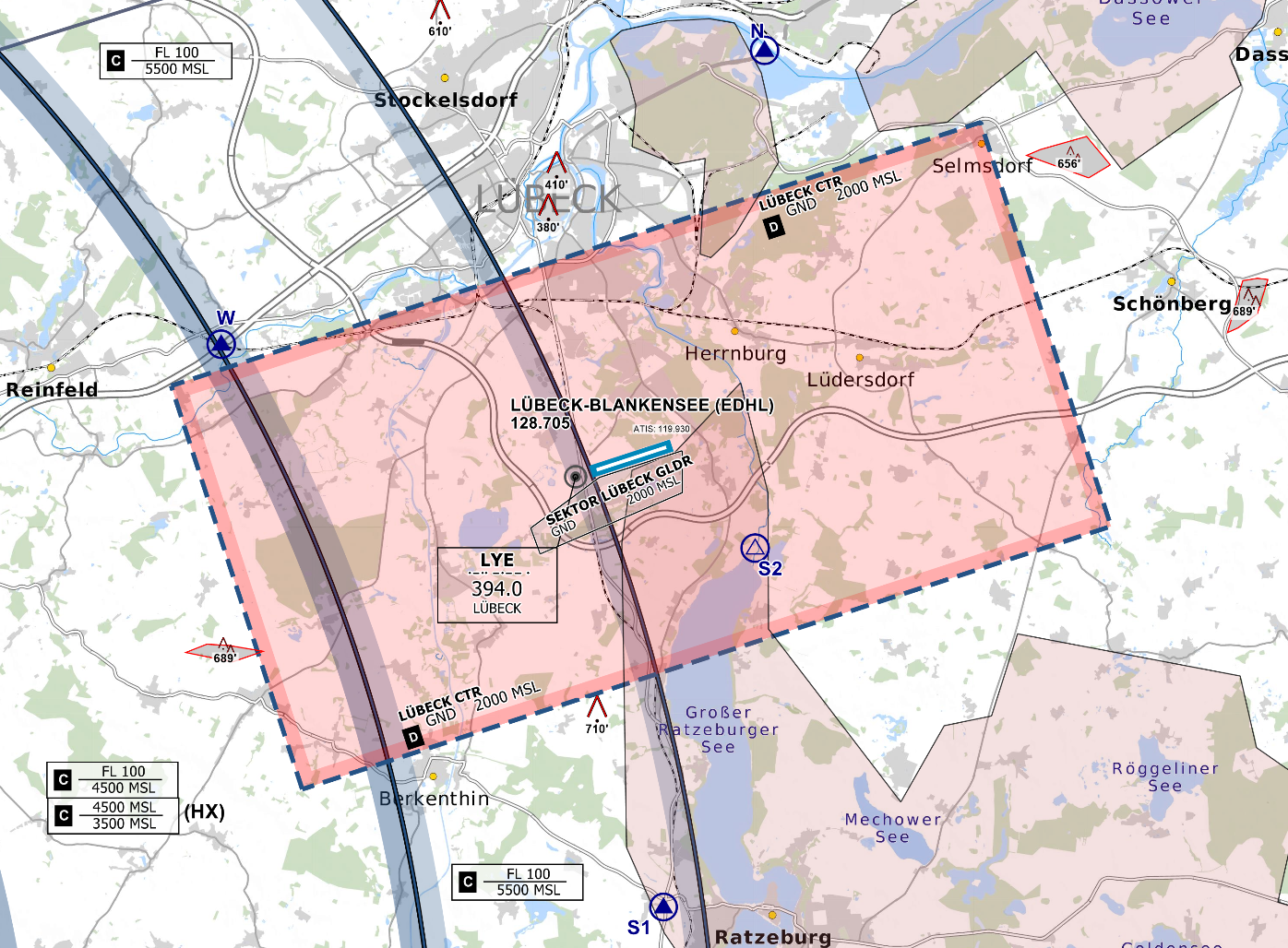](https://knowledgebase.vatsim-germany.org/uploads/images/gallery/2022-12/edhl-dctr.png) *Controlzone and VFR Reporting Points of Lübeck Airport - © [openflightmaps.org](https://www.openflightmaps.org/)* ### Runway and Airport Lübeck Airport has a 6896ft (2102m) long single runway (07 / 25) with Low-Visibility CAT II equipment on 07, as well as a grass glider strip south of the main runway. **The runway configuration is not dependent on EDDH but should always be considered and coordinated with Bremen Radar (Hamburg Approach).** The Airport features a small terminal building with check-in facilities, a shop and some restaurants. The apron has three stands, which are suitable for Class C aircrafts such as the Airbus A320, as well as some stands for smaller general aviation aircraft. ### Departures**All IFR Departures need a Departure-Release from Bremen Radar! \*** Coordinate early enough on TeamSpeak, as Bremen Radar might restrict the initial climb clearance and departures times due to workload and traffic situation.
\* If traffic permits, Radar can give a "*general departure release until further notice*". In that case the tower doesn't need to ask for each departure separately. **Spacing:** Departures shall be separated with a minimum of 3 nm or wake turbulence separated, whichever is greater. When two aircrafts have the same SID waypoint the separation shall be increased to 5 nm or wake turbulence separation whichever is greater. **Auto-Handoff:** Pilots shall contact Bremen Radar immediately after take-off without a specific handoff. ### VFR Lübeck Airport has four routes in and out of the CTR. Except S2, all other visual reporting points are mandatory.| **VRP** | **NOVEMBER** | **SIERRA (1+2)** | **LIMA** | **WHISKEY** |
|---|---|---|---|---|
| **NAV** | Lübeck Harbor | Leading to Ratzeburg, west of the Ratzeburger Lake | Elbe-Lübeck Canal between Berkenthin and Mölln | Highway A1 west of Lübeck |
**Whenever low visibility conditions exist, runway 07 should be used as the runway in use. Wind conditions shall be disregarded.**
During Low Visibility Operations at Lübeck, only runway 07 can be used for arriving traffic, as this runway is equipped with an ILS approach up to CAT II. Departing traffic may use both runway directions under the condition that the minimum takeoff RVR is met:| **Runway** | **Takeoff Minima** | **Condition** |
| 07 | 125 m RVR | --- |
| 25 | 400 m RVR | --- |
If the RVR is not below 400 m, departing traffic may request runway 25 due to performance reasons. In this case, close coordination with Bremen Radar is required before issuing the line-up clearance, as arriving traffic will still use runway 07 for landing.
**During Low Visibility Operations, Taxiway A shall be used for departing and arriving traffic exclusively. Arriving traffic needs to perform a backtrack in this case. Close coordination with Apron is required to avoid nose-to-nose situations on taxiway A.**
When the weather condition requires low visibility operations the use shall be announced in the ATIS.use ***&lvp*** in the ATIS maker URL
During low visibility operations, the departure and arrival spacing is increased. Delays may be issued earlier than in normal conditions. # EDVE - Braunschweig Airport # Overview
**Before staffing this airport for the first time:** Obtain a successful grade at the self enrollment Moodle course: **[EDVE - Braunschweig-Wolfsburg Tower](https://moodle.vatsim-germany.org/course/view.php?id=72)**.
Braunschweig Airport is located north of the city [Braunschweig](https://en.wikipedia.org/wiki/Braunschweig) in Lower Saxony, which is between Hannover and Magdeburg. This Airport traditionally has been a major center of gliding in Germany and is also used for general aviation, especially business traffic. It's the major hub of the Volkswagen Air Services and the closest suitable airport for the internationally playing Soccer team VFL Wolfsburg. The headquarters of the German Federal Aviation Office, the Luftfahrt-Bundesamt are located at the Airport, as well as the Research Fleet of the German Aerospace Center (DLR). The well known "NAV Checker" has its base at EDVE flying out to calibrate navigational stations like ILS and VORs in Germany. #### Main Operations, no scheduled public passenger or cargo services:| **VW Air Services** | Dessault Falcon 8X and 7X, Pilatus PC-24, A319CJ (retired) |
| **Privat Wings** | Dornier 328 and Beech 1900D |
| **NAV Checker** | Beech KingAir 350 |
| **Research Fleet DLR** | A320 (ATRA), ISTAR, Do 228, DR400, EC BO105 [and more](https://www.dlr.de/de/forschung-und-transfer/forschungsinfrastruktur/dlr-forschungsflotte) |
| **Soccer Clubs** | visiting the internationally playing VFL Wolfsburg |
| **Services** | King Air Service Center, Charter Flights, Para jumping, Glider |
| **Station** | **Station ID** | **Login** | **Frequency** | **Remark** |
| **ATIS** | AVE | EDVE\_ATIS | 134.455 | -- |
| **Tower** | VET | EDVE\_TWR | 120.055 | -- |
| **Arrival** | HAN | EDDV\_APP | 119.490 | -- |
| **Runway** | CAT 1 following a departing CAT 1 or 2 | CAT 2 following a departing CAT 1 or 2 | CAT 1 to 3 following a departing CAT 3 |
| RWY 08/26 | 600 m | --- | --- |
**All IFR Departures need a Departure-Release from Bremen Radar! \*** Coordinate early enough on TeamSpeak, as you might get a delay time, e.g. at EDDV events.
\* If traffic permits, Radar can give a "*general departure release until further notice*". In that case the tower doesn't need to ask for each departure separately. Departure Holding points are C (08) and A (26). Airliners usually also backtrack while lining up via C. Intersection D is often used for light aircraft. Intersection B should be avoided due to noise abatement. **Spacing:** Departures shall be separated with a minimum of 3 nm or wake turbulence separated, whichever is greater. When two aircrafts have the same SID waypoint the separation shall be increased to 5 nm or wake turbulence separation whichever is greater. **Auto-Handoff:** Pilots shall contact Bremen Radar immediately after take-off without a specific handoff. ### Arrivals Unless a pilot request a specific location (e.g. facilities at Taxiway H or F), they should get a taxi instruction leading to the Apron south of C with a stand of choice. Example: "*Taxi to stand of choice via A and C*" ### VFR Braunschweig offers 4 routes in and out of the CTR at max. 2000ft. Only the outer Waypoints are mandatory reporting points.| **VRP** | **N1** | **E1** | **W1** | **S** |
|---|---|---|---|---|
| **NAV** | Wedesbüttel north-west of the field | North of Cremlingen close to A39 intersection | A2 east of Peine | Trainline Intersection at Groß Gleidingen |
| **Route** | **Runway 08 Arrival** | **Runway 08 Departure** |
|---|---|---|
| **November** | N1 -> N2 (Traffic Circuit 08) | direct N1 |
| **Echo** | E1 -> E2 or directly into right Traffic Circuit 08 | right Turn E2 -> E1 (or direct E1) |
| **Sierra** | S -> right Base 08 | right Turn direct S |
| **Whiskey** | W1 -> W2 (following A2) | N2 -> W1 (north of Glider area) |
| **Route** | **Runway 26 Arrival** | **Runway 26 Departure** |
| **November** | N1 -> right Base 26 | W2 -> right Turn N1 (avoid glider area) |
| **Echo** | E1 -> E2 -> Final 26 | direct E1 |
| **Sierra** | S -> Traffic Circuit 26 | direct S |
| **Whiskey** | W1 -> N2 (right Traffic Circuit 26) | W2 -> W1 (following A2) |
**Early break-out to the North is NEVER approved due to glider area! Use W2/N2 accordingly.**
### Helicopters **Helipad:** The Helipads are not in use. They are turned off via NOTAM for years now. All Helicopters air-taxi to the runway. **Police and Rescue helicopters:** Expect Lower Saxony's state police helicopters from the Base in Gifhorn or Hannover (Bundespolizei, Callsign Phoenix) as well as possible crossings from Christoph Niedersachsen (CHX86). ## Ground [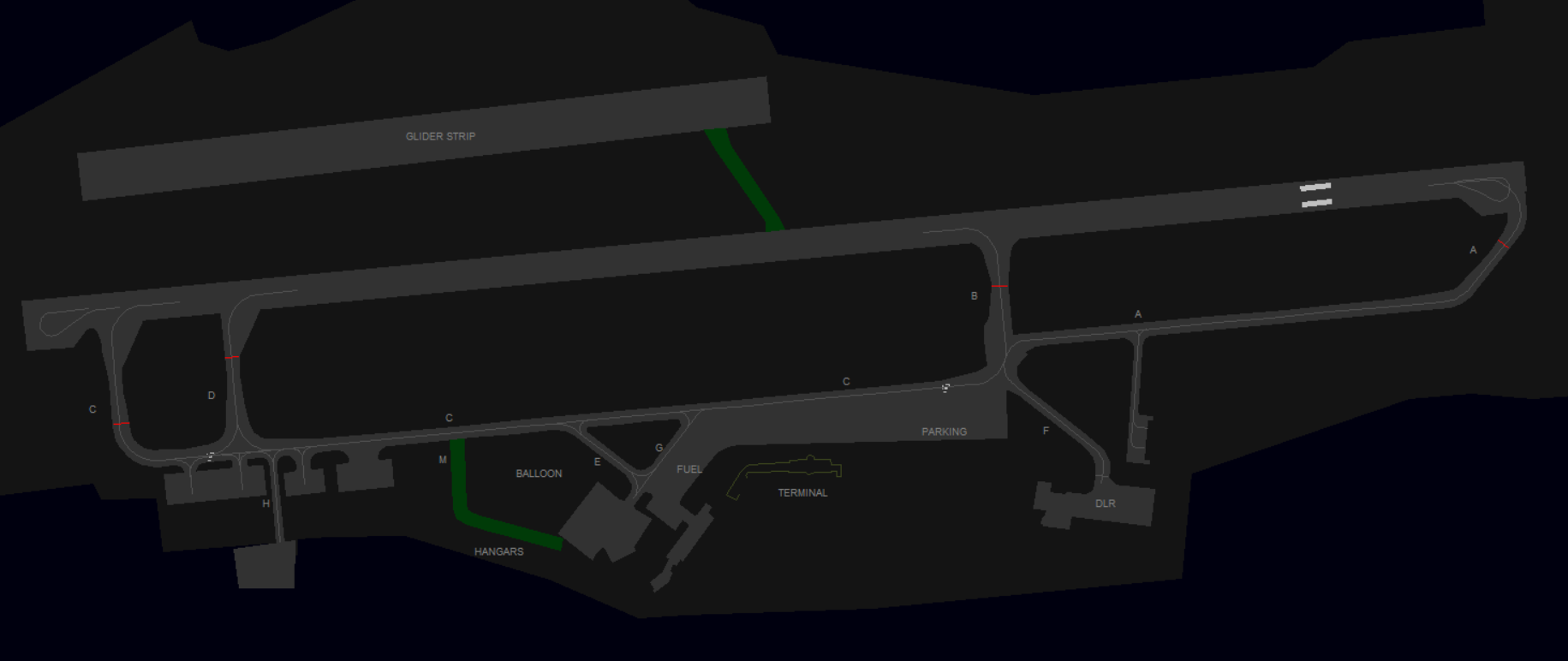](https://knowledgebase.vatsim-germany.org/uploads/images/gallery/2022-12/edhl-ground.png) ### Parking **Terminal:** Braunschweig features one main terminal building at the center part of the Airport. Various company facilities and hangars are based at the main taxiway C. **Airliner Stands:** On the main apron in front of the terminal building. **General Aviation:** The GAT is east of the Terminal on the main apron with enough space for some GA aircrafts. The Fuel station is west of the Terminal via taxiway G. **Volkswagen Air Service:** via Taxiway E/G. **Deutsche Luft- und Raumfahrt:** DLR has it's own apron reachable via taxiway F. **Aerodata (Nav Checker):** Hangars West of H - including a King Air maintenance center. **Business Aviation Center:** - via taxiway K east of F, also referred as Kroschke. On pilot request only, due to outdated sceneries. **De-Icing:** No special positions. De-Icing can be ordered at your current stand. ### Taxiways The area limit of ATC competence, which is shown on some charts, is not applicable on VATSIM, as we do not simulate airport operators. Tower maintains control over all ground activities. The main taxiways A-D are suitable for Class C aircrafts. Class D not yet confirmed.| **Taxiway** | **Notes** |
|---|---|
| **A, C** | Main Taxiway and Holding Points for departure |
| **B, D** | usually not used for departure, vacate only |
| **H** | Aircraft may only be towed and requires prior approval |
| **L + M** | Gras Taxiway only for instructed users (L = between Runway and Gliderstrip) |
| **F** | DLR private Apron |
| **K** | Business Aviation Center Kroschke (East of F) |
**Before staffing this airport for the first time:** Obtain a successful grade at the self enrollment Moodle course: **[EDVK - Kassel-Calden Tower](https://moodle.vatsim-germany.org/course/view.php?id=73)**.
Kassel Airport (formerly Kassel-Calden Airport) is a minor international airport serving the German city of [Kassel](https://en.wikipedia.org/wiki/Kassel "Kassel") in the state of Hesse. It is located in the north of Hesse close to the Lower Saxony Border in the northwest of Kassel and is mainly used for business and general aviation operations. Two flight schools and a parachuting school are based on site. ### Kassel ATC Stations| **Station** | **Station ID** | **Login** | **Frequency** | **Remark** |
| **ATIS** | VKA | EDVK\_ATIS | 129.205 | -- |
| **Ground** | VKG | EDVK\_GND | 121.905 | -- |
| **Tower** | VKT | EDVK\_TWR | 118.105 | -- |
| **Sector Harz** | HRZ | EDWW\_HRZ\_CTR | 124.240 | covered by EMS if not staffed |
| **Runway** | **ILS CAT I** | **ILS CAT II/III** | **LOC** | **RNP** | **NDB** |
| 09 | **✔** | **✔** | **✔** | ||
| 27 | **✔** | **✔** | **✔** | **✔** |
| **Taxiway** | **max. ACFT Cat** |
|---|---|
| **A, B, E, E4** | C |
| **C, E2** | D |
| **E3** | B |
| **L** | C |
| **SID** | **27** | **09** | **Climb** |
|---|---|---|---|
| **ELNAT** | 1W | 1E | 5000ft |
| **EMBAD** | 1W | 1E | 5000ft |
| **LUXUX** | 1W | 1E | 5000ft |
| **WERRA** | 1W | 1E | 5000ft |
| **WRB** *WARBURG* (RNAV) | 1W | 1E | 5000ft |
| **WRB** *WARBURG* (Non-RNAV) | 1K | 1C | 4000ft |
| **XAROL** | 1W | 1E | 5000ft |
**All E and W SIDs are for RNAV aircraft only. Non-RNAV aircraft shall always use the WRB1C or WRB1K departure. **
### Specials **Vectored departures:** The use of vectored departures requires prior coordination with the responsible radar station. An initial altitude to climb shall be provided. **IFR local flights:** IFR local flights are coordinated with the responsible radar controller, who may instruct a different departure procedure, possibly vectored departures. ### Low Visibility Operations (LVO) During LVO, Kassel Ground shall clear departing traffic to the CAT II/II holding point. The preferred runway during low-visibility conditions is runway 27.If the RVR is not below 125 m, departing traffic may request runway 09 due to performance reasons. In this case, close coordination with Kassel Tower is required before issuing the taxi clearance, as arriving traffic will still use runway 27 for landing.
# Tower Kassel Tower is responsible for all arriving and departing traffic. The top level of the airspace D control zone is 2700ft MSL. Above this altitude and around the CTR airspace E covers the area within responsibility of Bremen Radar. A Para jumping Area up to FL100 is directly above the airport. [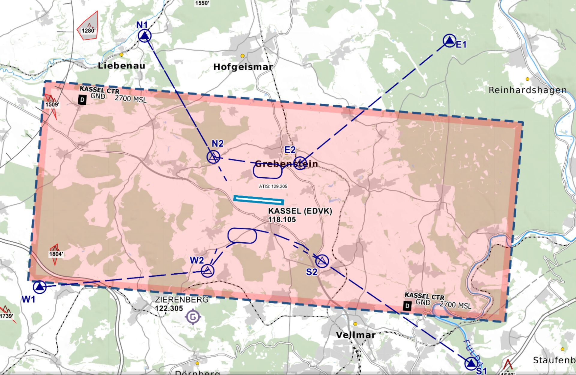](https://knowledgebase.vatsim-germany.org/uploads/images/gallery/2022-12/edvk-ctr.jpg)*Controlzone of Kassel Airport - © [openflightmaps.org](https://www.openflightmaps.org/)* ### Runway and Airport Kassel Airport has a 8200ft (2500m) long single runway (09 / 27) with a CAT IIIa/b Low-Visibility equipment available at runway 27. The airport features two aprons, one in front of the passenger terminal for two mid-sized aircraft such as the Airbus A320 family and a separate one for general aviation aircraft. ### Departures**All IFR Departures need a Departure-Release from Bremen Radar! \*** Coordinate early enough on TeamSpeak, as Bremen Radar might restrict the initial climb clearance and departures times due to workload and traffic situation.
\* If traffic permits, Radar can give a "*general departure release until further notice*". In that case the tower doesn't need to ask for each departure separately. **S****pacing:** Departures shall be separated with a minimum of 3 nm or wake turbulence separated, whichever is greater. When two aircrafts have the same SID waypoint (e.g. WRB) the separation shall be increased to 5 nm or wake turbulence separation whichever is greater. **Auto-Handoff:** Pilots shall remain on TWR frequency until passing 2500ft and then contact Bremen Radar without a specific handoff. Below 2000ft Radar might not understand the pilot due to interferences with the surrounding topography. ### Arrivals Arrivals shall be instructed to contact Ground when they are vacating while rolling on L. **Reduced Runway Separation (RRS):** Reduced Runway Separation can be applied for aircraft of category 1 and 2. ### VFR Kassel offers four routes in and out of the CTR with two published holding patterns in the north and south of the field. Only the outer Waypoints are mandatory reporting points.| **VRP** | **N1** | **E1** | **W1** | **S1** |
|---|---|---|---|---|
| **NAV** | Federal Road junction west of Hofgeismar | Reinhards Forest, Federal Road junction | West of Oberelsungen close to the Highway A44 | Fuldatal east of Kassel |
**Whenever low visibility conditions exist, runway 27 should be used as the runway in use. Wind conditions shall be disregarded.**
During Low Visibility Operations at Kassel, only runway 27 can be used for arriving traffic, as this runway is equipped with an ILS approach up to CAT III.If the RVR is not below 125 m, departing traffic may request runway 09 due to performance reasons. In this case, close coordination with Bremen Radar is required before issuing the line-up clearance, as arriving traffic will still use runway 27 for landing.
When the weather condition requires low visibility operations the use shall be announced in the ATIS.use ***&lvp*** in the ATIS maker URL
# EDXW - Sylt Airport # Overview**Before staffing this airport for the first time:** Obtain a successful grade at the self enrollment Moodle course: **[EDXW - Sylt-Westerland Tower](https://moodle.vatsim-germany.org/course/view.php?id=74)**.
Sylt Airport on the German Island Sylt in the North Sea is located 2km east of the main city Westerland. It mostly features summer seasonal scheduled traffic to major German cities as well as general aviation and gliding. #### Sylt ATC Stations| **Station** | **Station ID** | **Login** | **Frequency** | **Remark** |
| **ATIS** | AXW | EDXW\_ATIS | 118.400 | -- |
| **Tower** | XWT | EDXW\_TWR | 119.750 | -- |
| **Sector Eider** | EID | EDWW\_EID\_CTR | 124.075 | covered by ALR if not staffed |
| **Sector Aller** | ALR | EDWW\_ALR\_CTR | 126.325 | -- |
**All IFR Departures need a Departure-Release from Bremen Radar! \*** Coordinate early enough on TeamSpeak, as you might get a delay time, because of arriving traffic over OLDIP.
\* If traffic permits, Radar can always give a "*general departure release until further notice*". In that case the tower doesn't need to ask for each departure separately. **Spacing:** Departures shall be separated with a minimum of 5 nm or wake turbulence separated, whichever is greater, because there is only one useable SID per runway config. **Auto-Handoff:** Pilots shall contact Bremen Radar immediately after take-off without a specific handoff. ### Arrivals Unless a pilot request a specific location (e.g. facilities north-east), they should get a taxi instruction leading to the commercial Apron1 or general aviation Apron 2. For landing traffic 14/32, runway 06/24 can be used as taxiway as well. ### VFR Sylt offers 5 routes in and out of the CTR at max. 2000ft. All VFR Waypoints are mandatory reporting points.| **VRP** | **N** | **H** | **S1** | **E1** | **L** |
|---|---|---|---|---|---|
| **NAV** | North-West of the Island | South-West of the Island | South, east of Hönum | East, Trainline Intersection to the Island | North, East of List |
Overflying of build-up areas in the vicinity of the airport should be avoided. For this to comply, traffic circuits should be issued in the east of the field.
### Helicopters **Helipad:** There are no specific Helipads but pilots should expect Taxiway I (grass strip between Tower and Apron2/GAT) for landing. Otherwise on Tower discretion. The parking area is usually on the grass between Apron1 and Apron 2 ## Ground [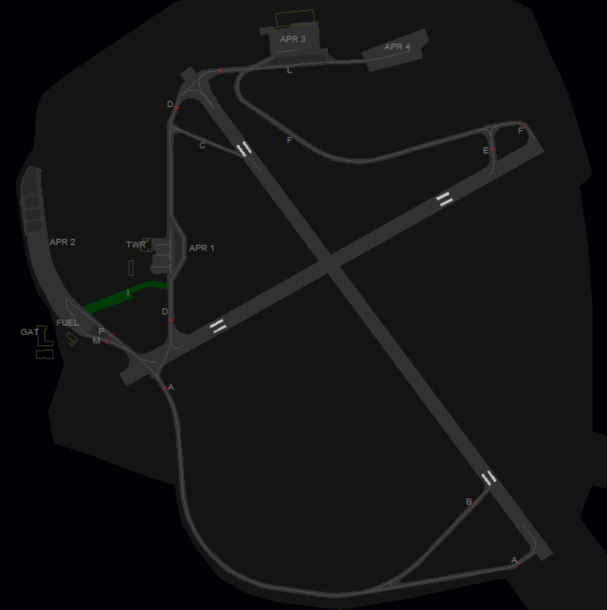](https://knowledgebase.vatsim-germany.org/uploads/images/gallery/2023-11/sylt-groundlayout.png) ### Parking **Airliner Stands:** Apron 1 has three airliner stands in front of the passenger terminal **Business Jets:** Apron 2 **General Aviation:** Apron 2 in the west of the field **Helicopters:** Gras area between Apron1 and Apron 2 behind the Tower or Apron 2 **Glider School:** Southeast of the field (opposite east of threshold runway 34) with own parking area next to the Glider Strip. **Apron 3 + Apron 4:** additional aprons, private hangars Parking at the fuel stations is strictly forbidden. ### Taxiways Hotspot zone at taxiway M and P at holding point runway 06. M is used for outgoing and P for incoming traffic. Taxiway B available up to 5.7 tons MTOW only. Taxiway I is a grass strip and can be used for aircrafts up to 2 tons MTOW (echo class), Note: not available in all sceneries, better use runway 06/24 to connect Apron 2 with taxiway D. ## Delivery VATSIM has the Top-Down principle, therefore IFR Clearances shall be given by the tower, contrary to real-life procedures, where these are given by Bremen Radar. Delivery Service is responsible for all departing flights under IFR. **Initial climb clearance:** The initial climb clearance at Sylt Airport is 4000ft on all published departure procedures. The altitude shall be entered as cleared altitude (CFL) in an appropriate list or tag. ### SIDs| **SID** | **14** | **32** | **Climb** |
|---|---|---|---|
| **OLDIP** | 1A (via SID) | 1B (via SID) | 4000ft |
| **Runway** | **Takeoff Minima** | **Condition** |
| 14/32 | 400 m RVR | During Day |
| 800 m RVR | During Night |
| **Station** | **Frequency** | **Login** | **SI** | **Anmerkung** |
| Tower | 122.100 | ETHB\_TWR | HBT | -- |
| Radar | 124.505 | ETHB\_APP | HBR | -- |
**If Bückeburg Radar is offline, Wunstorf Radar (ETNW APP) will take over full responsibility for AoR Bückeburg and top-down responsibilities at ETHB.**
# Tower #### Control Zone - D(HX) from GND to 2500 ft - VRPs: November 1/2/3/4, November Echo, Echo 1/2, Whiskey 1/2, Sierra 1/2/3 and Sierra Echo - Published Local Pattern North of AD (Helicopter at 750 ft MSL, other aircraft at 1250 ft MSL) - No published Jet Arrivals are available 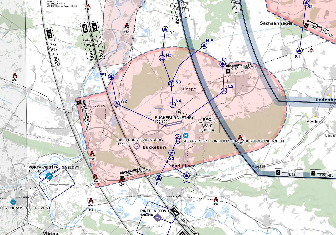*CTR Bückeburg - © [openflightmaps.org](https://www.openflightmaps.org/)* #### Ground Movements ##### Parking Positions Bückeburg consists of multiple Ramps. Bückeburg Tower should only instruct aircraft to taxi to a Ramp and not to a specific stand. ##### Taxi Instructions Bückeburg Tower doesn’t need to provide detailed taxi instructions to military traffic if there is no conflicting traffic. Visitors from other squadrons or civilian traffic should receive full taxi instructions. ##### Helicopter Lanes and Pads Bückeburg is equipped with one Helipad at Ramp 5 and 5 Helicopter Lanes. Helicopter Lanes can be regarded as normal grass runways parallel to runway 07/25 that can only be used by helicopters. Taxi instructions from and to Lane C West or Lane C East must include a runway crossing of 07/25. #### Departing Traffic Bückeburg Tower should inform departing traffic about current weather conditions. In the case of military traffic, the colour code is sufficient.**Bückeburg Tower shall only issue IFR clearances after coordination with EDWW sector Hannover (HAN)!**
**Every IFR departure from ETHB requires a departure release from both ETHB APP and Bremen Radar before issuing a takeoff clearance!**
##### SID-Assignments - OIDs named after the last two letters of the ICAO code of Bückeburg, ETHB - RWY 07 = HB107 - RWY 25 = HB125 - Initial Climb by ATC ##### Low Visibility Takeoffs (LVTO) RWY 07/25 is suitable for conducting low visibility takeoffs with a minimum runway visual range of 200m with helicopters. #### Arriving Traffic ##### Approaches Types Bückeburg is equipped with an RNAV (GPS) and a PAR approach onto runway 07 and an ILS, an RNAV (GPS) and a PAR approach onto runway 25. There are also NDB approaches available that will lead to the aerodrome, terminating into a circling approach onto both runways. Bückeburg Radar will maintain Radio contact with aircraft performing a PAR/SRA until landed. Bückeburg Tower should inform Bückeburg Radar if the runway is clear and the aircraft performing the PAR/SRA is cleared to land. # Radar ### Area of Responsibility Bückeburg Radar is responsible for departing and arriving traffic from/to ETHB. When online, Bückeburg Radar activates its delegated AoR within the Bremen ACC sector Hannover (HAN). Full responsibility is delegated to Bückeburg Radar for this airspace. 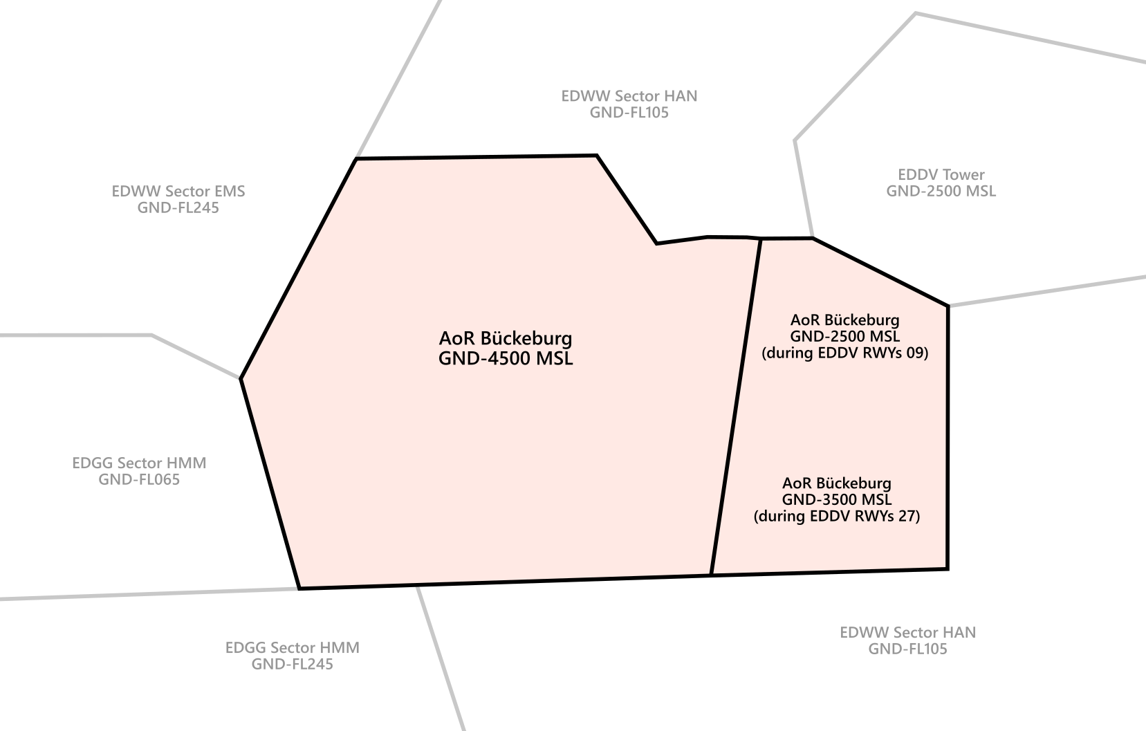*AoR Bückeburg***Bückeburg Radar shall inform Bremen ACC sectors HAN and EMS, Langen ACC sector HMM as well as Wunstorf Radar (ETNW APP) about the opening and closing of AoR Bückeburg immediately!**
**The east sector (sector B) of AoR Bückeburg is activated depending on the active runways at EDDV. The virtual controller shall always select the active runways at EDDV in Euroscope to load and AoR Bückeburg correctly.**
**If Bückeburg Radar is offline, Wunstorf Radar (ETNW APP) will take over full responsibility for AoR Bückeburg and top-down responsibilities at ETHB.**
### Procedures #### Arriving Traffic - Arriving traffic is always coordinated individually between Bremen Radar, Langen Radar Wunstorf Radar and Bückeburg Radar ("Radar Handover") - It's expected that Bückeburg accepts or otherwise states the sector entry conditions during coordination. #### Departing Traffic - Departing IFR traffic will be transferred from Bückeburg Tower to Bückeburg Radar initially. - Bückeburg Radar is responsible for verifying mode C readout and identifying the departing aircraft - Usually, Bückeburg Radar shall coordinate a further climb with EDWW before departure release or coordinate a general release of the climb. Preferably, this coordination is combined with IFR clearance or departure release. If no further climb is coordinated, departing IFR traffic leaving the AoR shall be transferred to Bremen Radar after identification. ### Approach Types #### Runway 07 - RNAV (GPS) - NDB from the north followed by circling - SRA - PAR #### Runway 25 - ILS - RNAV (GPS) - NDB from the north followed by circling - SRA - PARSince **Bückeburg Precision is currently not implemented on VATSIM**, PAR approaches can only be conducted if traffic levels permit - if necessary, Bückeburg Radar can coordinate with civilian ATC to keep other inbound traffic outside of the airspace while a PAR approach is taking place; whether this is possible, however, depends on the current workload of civilian ATC.
# ETHC - Celle # Overview ### Celle Overview Celle is a military airfield in the northeast of Hannover which is operated by the German Army. Currently, there is no Squadron stationed there. Charts can be found in the [MIL AIS](https://www.milais.org/). - VFR Charts: Library → Under Publication select “[GEMIL FLIP VAD](https://www.milais.org/publications.php)” → Celle - IFR Charts: Library → CENOR FLIP→ [Aerodromes ](https://www.milais.org/cenor.php?ZnJtaWQ9MA==)→ Celle ### Celle ATC Stations| **Station** | **Frequency** | **Login** | **SI** | **Anmerkung** |
| Tower | 118.255 | ETHC\_TWR | HCT | -- |
| Radar | 123.305 | ETHC\_APP | HCR | -- |
**If Fassberg Radar (ETHS APP) is offline, Celle Radar will take over full responsibility for AoR Fassberg and top-down responsibilities at ETHS. Therefore, Celle Radar shall consult the SOP of Fassberg before connecting to the Vatsim network.**
# Tower #### Control Zone - D(HX) from GND to 2500 ft - VRPs: November 1/2 , Whiskey 1/2, Sierra 1/2 - Published Local Pattern North of AD (Helicopter at 650 ft MSL, Helicopter with Night-Vision-Goggles at 400 ft MSL, other aircraft at 1200 ft MSL) - There are also VFR Jet arrivals and VFR Jet departures that are used for military Jets. The Jet arrivals/departures consist of one mandatory reporting point outside the CTR and its respected Initial point in front of the runway. Jets will cross the initial point at 1700 ft MSL. - For arrivals to runway 08 Entry North and Entry West will be used. For arrivals to runway 26 Entry East and Entry South will be used. - For departures from runway 26 Exit East and Exit South will be used. For departures from runway 26 Exit North and Exit West will be used.It’s important to remember that Jets on the VFR Jet arrival will overfly the airport at 1700 ft to make an Overhead Approach Maneuver to the south and then join the final as published in the chart!
*CTR Celle - © [openflightmaps.org](https://www.openflightmaps.org/)* #### Ground Movements ##### Parking Positions Celle consists of multiple Aprons. Celle Tower should only instruct aircraft to taxi to a Ramp and not to a specific stand. - Helicopter should park on Apron 1, 2, 3 and 4 - Aircraft should park on Apron 1 or 2 ##### Taxiway Restrictions At Celle, the following taxiway restrictions apply: - Yellow Guidance Line: Approved for all aircraft - Orange Guidance Line: Approved up to light and medium helicopters and fixed-wing Cat A-B aircraft - Blue Guidance Line: Approved up to heavy helicopters and fixed-wing Cat C-D aircraft The colour of the guidance line can be seen in the ground layout of the EDWW Euroscope package: [](https://knowledgebase.vatsim-germany.org/uploads/images/gallery/2024-10/euroscope-q4uxp7xpfk.png) ##### Taxi Instructions Celle Tower doesn’t need to provide detailed taxi instructions to military traffic if there is no conflicting traffic. Civilian traffic should receive full taxi instructions. ##### Helicopter Lanes and Pads Celle is equipped with one Helipad at taxiway Y and 5 Helicopter Lanes. Helicopter Lanes can be regarded as normal grass runways parallel to runway 08/26 that can only be used by helicopters. #### Departing Traffic Celle Tower should inform departing traffic about current weather conditions. In the case of military traffic, the colour code is sufficient.**Celle Tower shall only issue IFR clearances after coordination with EDWW sector Hannover (HAN)!**
**Every IFR departure from ETHC requires a departure release from both ETHC APP and Bremen Radar before issuing a takeoff clearance!**
##### SID-Assignments - Besides SIDs, so-called Operational Instrument Departures (OIDs) are available (HC108 and HC126), initial climb by ATC| **Via Waypoint/Direction** | **SID Runway 08** | **SID Runway 26** | **Initial Climb** |
| AMALI | AMALI1D | AMALI1C | By ATC |
| NIE | NIE1D | NIE1C | By ATC |
| OBATU | OBATU1D | OBATU1C | By ATC |
**Celle Radar shall inform Bremen ACC sector HAN, Faßberg Radar (ETHS APP) as well as Wunstorf Radar (ETNW APP) about the opening and closing of AoR Celle immediately!**
**If Fassberg Radar (ETHS APP) is offline, Celle Radar will take over full responsibility for AoR Fassberg and top-down responsibilities at ETHS. Therefore, Celle Radar shall consult the SOP of Fassberg before connecting to the Vatsim network.**
### Procedures #### Arriving Traffic - Arriving traffic is always coordinated individually between Bremen Radar, Faßberg Radar, Wunstorf Radar and Celle Radar ("Radar Handover") - It's expected that Celle Radar accepts or otherwise states the sector entry conditions during coordination. #### Departing Traffic - Departing IFR traffic will be transferred from Celle Tower to Celle Radar initially. - Celle Radar is responsible for verifying mode C readout and identifying the departing aircraft - Usually, Celle Radar shall coordinate a further climb with EDWW before departure release or coordinate a general release of the climb. Preferably, this coordination is combined with IFR clearance or departure release. If no further climb is coordinated, departing IFR traffic leaving the AoR shall be transferred to Bremen Radar after identification. ### Approach Types #### Runway 08 - RNP - NDB (Copter) - SRA - PAR #### Runway 26 - RNP - NDB - SRA - PARSince **Celle Precision is currently not implemented on VATSIM**, PAR approaches can only be conducted if traffic levels permit - if necessary, Celle Radar can coordinate with civilian ATC to keep other inbound traffic outside of the airspace while a PAR approach is taking place; whether this is possible, however, depends on the current workload of civilian ATC.
# ETHS - Fassberg # Overview ### Fassberg Overview Fassberg is a military airfield located between Hamburg and Hannover which is operated by the German Army. Currently, "Transporthubschrauberregiment 10" is stationed at Fassberg. Charts can be found in the [MIL AIS](https://www.milais.org/). - VFR Charts: Library → Under Publication select “[GEMIL FLIP VAD](https://www.milais.org/publications.php)” → Fassberg - IFR Charts: Library → CENOR FLIP→ [Aerodromes ](https://www.milais.org/cenor.php?ZnJtaWQ9MA==)→ Fassberg ### Fassberg ATC Stations| **Station** | **Frequency** | **Login** | **SI** | **Anmerkung** |
| Tower | 118.525 | ETHS\_TWR | HST | -- |
| Radar | 119.355 | ETHS\_APP | HSR | -- |
**If Fassberg Radar is offline, Celle Radar (ETHC APP) will take over full responsibility for AoR Fassberg and top-down responsibilities at ETHS.**
# Tower #### Control Zone - D(HX) from GND to 2500 ft - VRPs: November 1/2 , Whiskey, Sierra, Lima, Mike 1/2 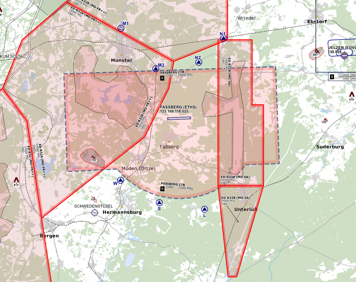*CTR Fassberg - © [openflightmaps.org](https://www.openflightmaps.org/)* #### Ground Movements ##### Parking Positions Fassberg consists of one main Apron with multiple Hangars. Fassberg Tower should only instruct aircraft to taxi to the apron and not to a specific stand. ##### Taxi Instructions Fassberg Tower doesn’t need to provide detailed taxi instructions to military traffic if there is no conflicting traffic. Visitors from other squadrons (home squadron is TrspHubschrRgt 10) or civilian traffic should receive full taxi instructions. ##### Helicopter Lanes and Pads Fassberg is equipped with two Helicopter Lanes. Helicopter Lanes can be regarded as normal grass runways parallel to runway 09/27. LANE 09/27 (NORTHLANE) is only available for prop aircraft and emergency landings. LANE 06/24 (SOUTHLANE) is only available for helicopters. #### Departing Traffic Fassberg Tower should inform departing traffic about current weather conditions. In the case of military traffic, the colour code is sufficient.**Fassberg Tower shall only issue IFR clearances after coordination with EDWW sector Hannover (HAN)!**
**Every IFR departure from ETHS requires a departure release from both ETHS APP and Bremen Radar before issuing a takeoff clearance!**
##### SID-Assignments - Only Operational Instrument Departures (OIDs) are available (HS109 and HS127), initial climb by ATC #### Arriving Traffic ##### Approaches Types Fassberg is not equipped with any published IFR approaches. PAR and SAR approaches can be used instead, which are available for both runways. Fassberg Radar will maintain Radio contact with the aircraft performing a PAR or SAR until landed. Fassberg Tower should inform Fassberg Radar if the runway is clear and the aircraft performing the PAR/SRA is cleared to land. # Radar ### Area of Responsibility Fassberg Radar is responsible for departing and arriving traffic from/to ETHS. When online, Fassberg Radar activates its delegated AoR within the Bremen ACC sector Hannover (HAN). Full responsibility is delegated to Fassberg Radar for this airspace. 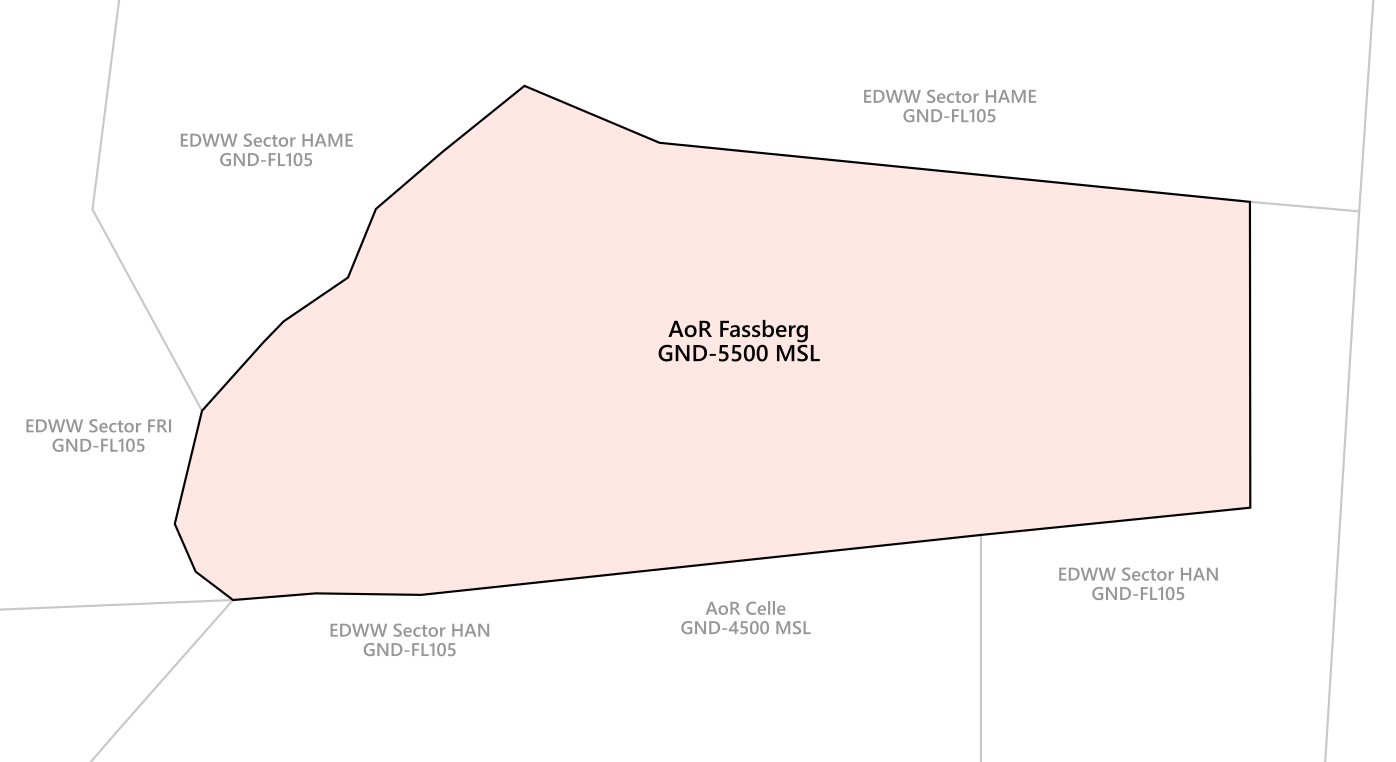*AoR Fassberg***Fassberg Radar shall inform Bremen ACC sectors HAN, FRI and HAME as well as Celle Radar (ETHC APP) about the opening and closing of AoR Fassberg immediately!**
**If Fassberg Radar is offline, Celle Radar (ETHC APP) will take over full responsibility for AoR Fassberg and top-down responsibilities at ETHS.**
### Procedures #### Arriving Traffic - Arriving traffic is always coordinated individually between Bremen Radar, Celle Radar and Fassberg Radar ("Radar Handover") - It's expected that Fassberg Radar accepts or otherwise states the sector entry conditions during coordination. #### Departing Traffic - Departing IFR traffic will be transferred from Fassberg Tower to Fassberg Radar initially. - Fassberg Radar is responsible for verifying mode C readout and identifying the departing aircraft - Usually, Fassberg Radar shall coordinate a further climb with EDWW before departure release or coordinate a general release of the climb. Preferably, this coordination is combined with IFR clearance or departure release. If no further climb is coordinated, departing IFR traffic leaving the AoR shall be transferred to Bremen Radar after identification. ##### ED-R 33A During the activity of ED-R 33A, Fassberg Radar shall coordinate a crossing clearance for aircraft on an instrument approach. ### Approach Types #### Runway 09 - SRA - PAR #### Runway 27 - SRA - PARSince **Fassberg Precision is currently not implemented on VATSIM**, PAR approaches can only be conducted if traffic levels permit - if necessary, Bückeburg Radar can coordinate with civilian ATC to keep other inbound traffic outside of the airspace while a PAR approach is taking place; whether this is possible, however, depends on the current workload of civilian ATC
# ETMN - Nordholz # Overview ### Nordholz Overview Nordholz is the last military airfield in Germany operated by the German Navy. It is located to the west of Hamburg and is the home of the Naval Air Wing 3 and 5 by the German Navy. For the most part, Nordholz handles Military Helicopter and Medium reconnaissance aircraft like the P-3C Orion and Dornier 228 LM. Charts can be found in the [MIL AIS](https://www.milais.org/). - VFR Charts: Library → Under Publication select “[GEMIL FLIP VAD](https://www.milais.org/publications.php)” → Nordholz - IFR Charts: Library → CENOR FLIP→ [Aerodromes ](https://www.milais.org/cenor.php?ZnJtaWQ9MA==)→ Nordholz ### Nordholz ATC Stations| **Station** | **Frequency** | **Login** | **SI** | **Anmerkung** |
| Tower | 131.255 | ETMN\_TWR | MNT | -- |
| Radar | 129.855 | ETMN\_APP | MNR | -- |
**If Nordholz Radar is offline, Wittmund Radar (ETNT APP) will take over full responsibility for AoR Nordholz and top-down responsibilities at ETMN.**
# Tower #### Control Zone - D(HX) from GND to 2600 ft - VRPs: November, Sierra, Echo, Lima, Whiskey - There are also VFR Jet arrivals that are used for military Jets. The Jet arrivals consist of one mandatory reporting point outside the CTR and its respected Initial point in front of the runway. Jets will cross the initial point at 1500 ft MSL. - For arrivals to runway 08, Entry West will be used. For arrivals to runway 26, Entry East will be used. - The published jet pattern is situated south of runway 08/26It’s important to remember that Jets on the VFR Jet arrival will overfly the airport at 1500 ft to make an Overhead Approach Maneuver to the south and then join the final as published in the chart!
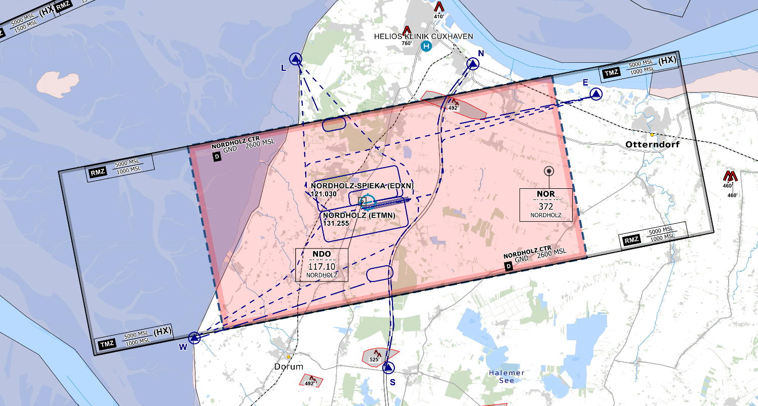*CTR Nordholz - © [openflightmaps.org](https://www.openflightmaps.org/)* #### Ground Movements ##### Parking Positions Nordholz consists of multiple Aprons with multiple Hangars. Nordholz Tower should only instruct aircraft to taxi to the apron. ##### Taxi Instructions Nordholz Tower doesn’t need to provide detailed taxi instructions to military traffic if there is no conflicting traffic. Visitors from other squadrons (home squadron is Naval Air Wing 3 and 5) or civilian traffic should receive full taxi instructions. #### Departing Traffic Nordholz Tower should inform departing traffic about current weather conditions. In the case of military traffic, the colour code is sufficient.**Nordholz Tower shall only issue IFR clearances after coordination with EDWW sector Eider West (EIDW)!**
**Every IFR departure from ETMN requires a departure release from both ETMN APP and Bremen Radar before issuing a takeoff clearance!**
##### SID-Assignments - Operational Instrument Departures (OIDs) are used (MN108 and MN126), initial climb by ATC. ##### Low Visibility Takeoffs (LVTO) RWY 08/26 is suitable for conducting low visibility takeoffs with a minimum runway visual range of 100m. #### Arriving Traffic ##### Approaches Types Wittmundhafen is equipped with an ILS and TACAN approach onto runway 08 and an ILS, RNP, TACAN and NDB approach onto runway 26. There are also PAR and SRA approaches available on both runways. Nordholz Radar will maintain Radio contact with the aircraft performing a PAR or SAR until landed. Nordholz Tower should inform Nordholz Radar if the runway is clear and the aircraft performing the PAR/SRA is cleared to land. #### Nordholz-Spieka (EDXN) Nordholz-Spieka (EDXN) is an uncontrolled airfield directly situated to ETMN. Traffic shall only use the grass runway. Spieka Radio and Nordholz Tower shall maintain close coordination in case of traffic at each aerodrome. VFR departure and approach procedures shall be assigned as directed by Nordholz Tower. # Radar ### Area of Responsibility Nordholz Radar is responsible for departing and arriving traffic from/to ETMN. When online, Nordholz Radar activates its delegated AoR within the Bremen ACC sector Eider West (EIDW). Full responsibility is delegated to Wittmund Radar for this airspace. 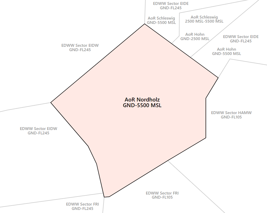*AoR Nordholz***Nordholz Radar shall inform Bremen ACC sectors EIDW/EIDE, FRI and HAMW as well as Wittmund Radar (ETNT APP), Hohn Radar (ETNH APP) and Schleswig Radar (ETNS APP) about the opening and closing of AoR Wittmund immediately!**
**If Nordholz Radar is offline, Wittmund Radar (ETNT APP) will take over full responsibility for AoR Nordholz and top-down responsibilities at ETMN.**
### Airspace 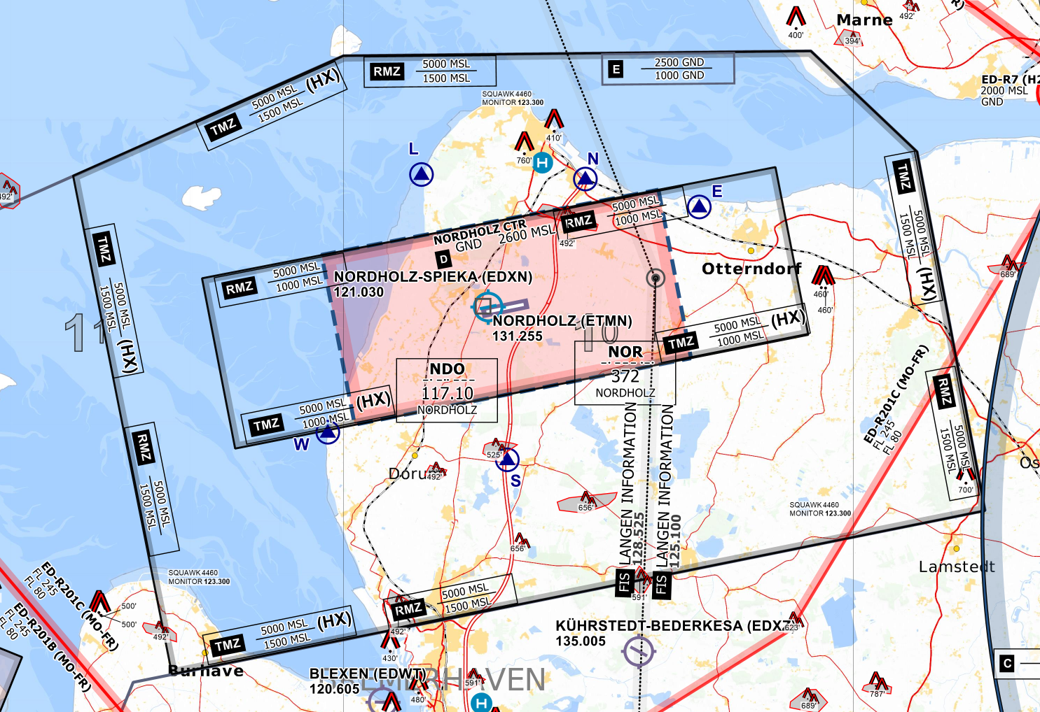 Nordholz is equipped with a TMZ and RMZ. This will ensure that VFR traffic in the vicinity of the aerodrome is known to Nordholz Radar. The RMZ will only be used by traffic not equipped with a transponder (not applicable in Vatsim). Traffic within the TMZ of Nordholz shall monitor Nordholz Radar's frequency and squawk 4460. This traffic is not required to make an initial call to ATC. Still, ATC may contact this traffic when required (e.g. traffic information about IFR traffic). ### Procedures #### Arriving Traffic - Arriving traffic is always coordinated individually between Bremen Radar, Wittmund Radar, Hohn Radar, Schleswig Radar and Nordholz Radar ("Radar Handover") - It's expected that Nordholz Radar accepts or otherwise states the sector entry conditions during coordination. #### Departing Traffic - Departing IFR traffic will be transferred from Nordholz Tower to Nordholz Radar initially. - Nordholz Radar is responsible for verifying mode C readout and identifying the departing aircraft - Usually, Nordholz Radar shall coordinate a further climb with EDWW before departure release or coordinate a general release of the climb. Preferably, this coordination is combined with IFR clearance or departure release. If no further climb is coordinated, departing IFR traffic leaving the AoR shall be transferred to Bremen Radar after identification. ### Approach Types #### Runway 08 - ILS - TACAN - SRA - PAR #### Runway 26 - ILS - RNP - TACAN - NDB - SRA - PARSince **Nordholz Precision is currently not implemented on VATSIM**, PAR approaches can only be conducted if traffic levels permit - if necessary, Nordholz Radar can coordinate with civilian ATC to keep other inbound traffic outside of the airspace while a PAR approach is taking place; whether this is possible, however, depends on the current workload of civilian ATC.
# ETND - Diepholz # Overview ### Diepholz Overview Diepholz is a military airfield in the south of Bremen. Additionally, Diepholz is also used by civil general aviation traffic. Charts can be found in the [MIL AIS](https://www.milais.org/). - VFR Charts: Library → Under Publication select “[GEMIL FLIP VAD](https://www.milais.org/publications.php)” → Diepholz - IFR Charts: Library → CENOR FLIP→ [Aerodromes ](https://www.milais.org/cenor.php?ZnJtaWQ9MA==)→ Bückeburg ### Diepholz ATC Stations| **Station** | **Frequency** | **Login** | **SI** | **Anmerkung** |
| Tower | 135.130 | ETND\_TWR | NDT | -- |
| Radio | 122.530 | ETND\_I\_TWR | NDR | -- |
Diepholz Radio may be used whenever Diepholz Tower is closed. Normal AFIS regulations apply. Diepholz Tower always has priority in staffing ETND on Vatsim.
# Tower #### Control Zone - D(HX) from GND to 2500 ft - VRPs: Sierra in the south of the CTR (leaving via S only from RWY 08) - Traffic circuits are only allowed south of the runway - No published Jet Arrivals are available 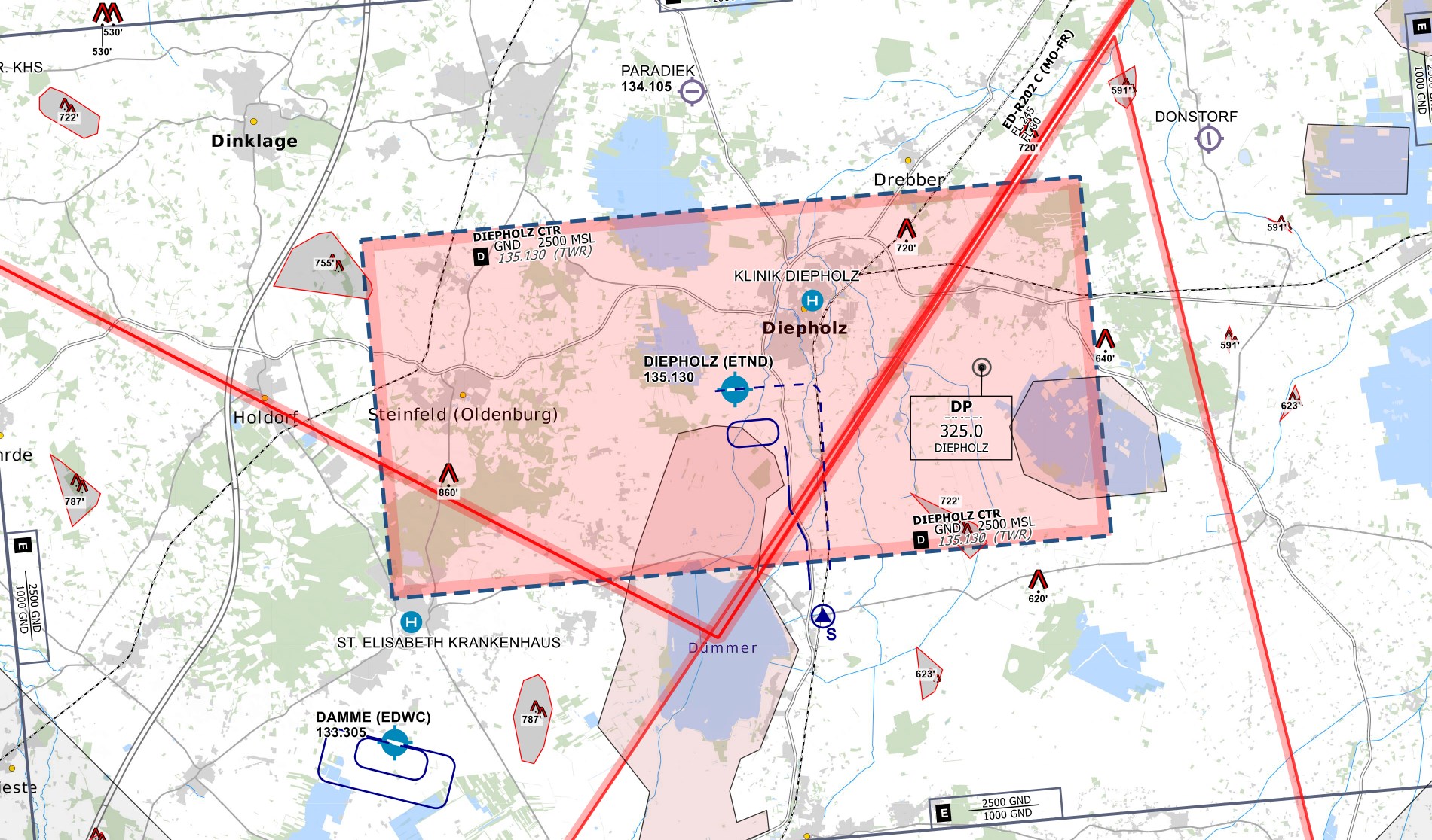*CTR Diepholz - © [openflightmaps.org](https://www.openflightmaps.org/)* #### Ground Movements ##### Parking Positions Diepholz consists of multiple military ramps. The ramps north of the runway are primarily used for military traffic. Civil aviation traffic shall use the apron south of runway 26's threshold. ##### Taxi Instructions Diepholz Tower shall not provide detailed taxi instructions. Traffic will only be instructed to hold short of the runway and to report ready for departure. ##### Helicopter Lanes and Pads Diepholz is equipped with two Helipads on the taxiway north of the runway and one Helicopter Lane. The Helicopter Lane can be regarded as normal grass runways parallel to runway 08/26 that can only be used by helicopters. #### Departing Traffic Diepholz Tower should inform departing traffic about current weather conditions. In the case of military traffic, the colour code is sufficient.**Diepholz Tower shall only issue IFR clearances after coordination with EDWW sector Ems (EMS)!**
**Every IFR departure from ETND requires a departure release from Bremen Radar before issuing a takeoff clearance!**
##### SID-Assignments - Only Operational Instrument Departures (OIDs) are available (ND108 and ND126), initial climb by ATC #### Arriving Traffic ##### Approaches Types Diepholz is equipped with an RNAV (GPS) approach onto runway 08 and an NDB and a COPTER NDB approach onto runway 26. SRA and PAR approaches are not available at ETND. # ETNH - Hohn # Overview ### Hohn Overview Hohn is a military airfield in the north of Germany and is a reserve airfield of the Taktischen Luftwaffengeschwader 51 by the German Airforce. Charts can be found in the [MIL AIS](https://www.milais.org/). - VFR Charts: Library → Under Publication select “[GEMIL FLIP VAD](https://www.milais.org/publications.php)” → Hohn - IFR Charts: Library → CENOR FLIP→ [Aerodromes ](https://www.milais.org/cenor.php?ZnJtaWQ9MA==)→ Hohn ### Hohn ATC Stations| **Station** | **Frequency** | **Login** | **SI** | **Anmerkung** |
| Tower | 122.100 | ETNH\_TWR | NHT | -- |
| Radar | 122.700 | ETNH\_APP | NHR | -- |
| Precision | 125.600 | ETNH\_P\_APP | NHP | -- |
**If Hohn Radar is offline, Schleswig Radar (ETNS APP) will take over full responsibility for AoR Hohn and top-down responsibilities at ETNH.**
# Tower #### Control Zone - D(HX) from GND to 2600 ft - VRPs: Whiskey, Echo, Sierra, Tango - The minimum pattern altitude is 500ft AGL, the pattern altitude for fixed-wing aircraft is 1000ft AGL - There are also VFR Jet arrivals/departures that are used for military Jets. The Jet arrivals consist of two mandatory reporting points each and its respected Initial point in front of the runway. - For arrivals to runway 08, Entry West will be used. For arrivals to runway 26, Entry East will be used. - For departures from runway 08, Exit East will be used. For departures from runway 26, Exit West will be used.It’s important to remember that Jets on the VFR Jet arrival will overfly the airport at 1600 ft to make an Overhead Approach Maneuver to the south and then join the final as published in the chart!
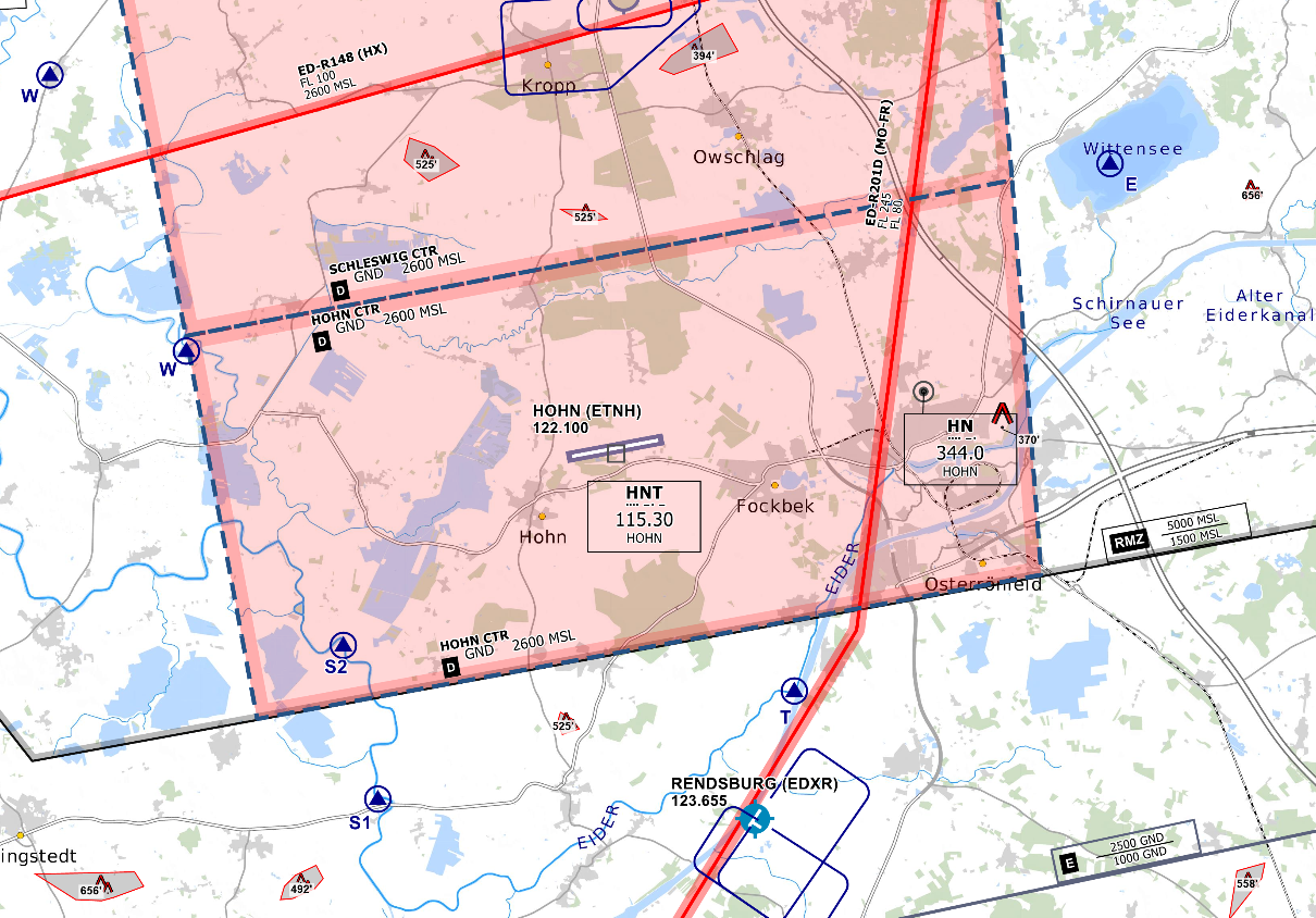*CTR Hohn - © [openflightmaps.org](https://www.openflightmaps.org/)* #### Ground Movements ##### Parking Positions Hohn consists of multiple ramps. Hohn Tower should only instruct aircraft to taxi to the ramp. ##### Taxi Instructions Hohn Tower doesn’t need to provide detailed taxi instructions to military traffic if there is no conflicting traffic. Visitors from other squadrons (home squadron is TaktLwg 51) or civilian traffic should receive full taxi instructions. #### Departing Traffic Hohn Tower should inform departing traffic about current weather conditions. In the case of military traffic, the colour code is sufficient.**Hohn Tower shall only issue IFR clearances after coordination with EDWW sector Eider East (EIDE)!**
**Every IFR departure from ETNH requires a departure release from both ETNH APP and Bremen Radar before issuing a takeoff clearance!**
##### SID-Assignments - Operational Instrument Departures (OIDs) are used (NH108 and NH126), initial climb by ATC. #### Arriving Traffic ##### Approach Types Hohn is equipped with a TACAN and RNP approach onto runway 08 and an ILS, RNP and TACAN approach onto runway 26. There are also PAR and SRA approaches available on both runways. Hohn Precision will maintain Radio contact with the aircraft performing a PAR until landed. Hohn Tower should inform Hohn Precision if the runway is clear and the aircraft performing the PAR is cleared to land. #### Schleswig (ETNS) Hohn Tower shall inform Schleswig Tower about the activation and closure of CTR Hohn. # Radar ### Area of Responsibility Hohn Radar is responsible for departing and arriving traffic from/to ETNH. When online, Hohn Radar activates its delegated AoR within the Bremen ACC sector Eider East (EIDE). Full responsibility is delegated to Hohn Radar for this airspace. 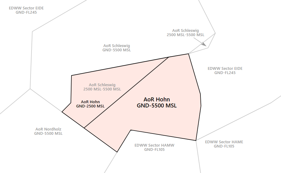*AoR Hohn***Hohn Radar shall inform Bremen ACC sectors EIDE and HAMW as well as Nordholz Radar (ETMN APP) and Schleswig Radar (ETNS APP) about the opening and closing of AoR Hohn immediately!**
**If Hohn Radar is offline, Schleswig Radar (ETNS APP) will take over full responsibility for AoR Hohn and top-down responsibilities at ETNH.**
### Airspace 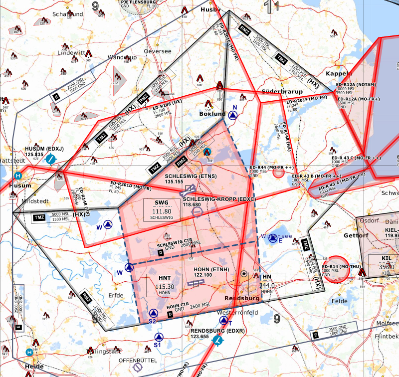 Hohn/Schleswig is equipped with a TMZ and RMZ. This will ensure that VFR traffic in the vicinity of the aerodrome is known to Hohn/Schleswig Radar. The RMZ will only be used by traffic not equipped with a transponder (not applicable in Vatsim). Traffic within the TMZ of Hohn/Schleswig shall monitor Schleswig Radar's frequency and squawk 4476. This traffic is not required to make an initial call to ATC. Still, ATC may contact this traffic when required (e.g. traffic information about IFR traffic). ### Procedures #### Arriving Traffic - Arriving traffic is always coordinated individually between Bremen Radar, Schleswig Radar and Hohn Radar ("Radar Handover") - It's expected that Hohn Radar accepts or otherwise states the sector entry conditions during coordination. #### Departing Traffic - Departing IFR traffic will be transferred from Hohn Tower to Hohn Radar initially. - Hohn Radar is responsible for verifying mode C readout and identifying the departing aircraft - Usually, Hohn Radar shall coordinate a further climb with EDWW before departure release or coordinate a general release of the climb. Preferably, this coordination is combined with IFR clearance or departure release. If no further climb is coordinated, departing IFR traffic leaving the AoR shall be transferred to Bremen Radar after identification. ### Approach Types #### Runway 08 - TACAN - RNP - SRA - PAR #### Runway 26 - ILS - TACAN - RNP - SRA - PAR ### Hohn Precision - Is only responsible for PAR approaches - Traffic is controlled by a special radar system - Hohn Radar will issue an initial vector leading to the final before performing a radar handover to Hohn Precision - Only one aircraft at a time shall be on the frequency of Hohn Precision # ETNL - Rostock-Laage # OverviewOn Moodle, a non-mandatory SOP Test can be found under [**ETNL - Rostock-Laage Tower/Ground**](https://moodle.vatsim-germany.org/course/view.php?id=84)
### Rostock-Laage Overview Laage is a military airfield with Civil Joint User south of Rostock which is home of the Taktische Luftwaffengeschwader 73 by the German Air Force. For the most part, Laage handles Military Jet traffic and civilian Airliners. There is also a Police and a rescue Helicopter stationed at Laage. Charts can be found in the [MIL AIS](https://www.milais.org/). - VFR Charts: Library → Under Publication select “[GEMIL FLIP VAD](https://www.milais.org/publications.php)” → Laage - IFR Charts: Library → CENOR FLIP→ [Aerodromes ](https://www.milais.org/cenor.php?ZnJtaWQ9MA==)→ Laage ### Rostock-Laage ATC Stations| **Station** | **Frequency** | **Login** | **SI** | **Anmerkung** |
| ATIS | 134.605 | ETNL\_ATIS | ALT | -- |
| Apron | 121.955 | ETNL\_A\_GND | NLA | -- |
| Tower | 118.430 | ETNL\_TWR | NLT | -- |
| Radar | 123.300 | ETNL\_APP | NLR | -- |
| Precision Radar | 133.105 | ETNL\_P\_APP | NLP | -- |
| **Runway** | **Takeoff Minima** | **Condition** |
| 09/27 | 400 m RVR | During Day |
| 800 m RVR | During Night |
**Laage Apron shall only issue IFR clearances after coordination with EDWW sector Müritz!**
#### Datalink Clearance (PDC/DCL) The Datalink Clearance System is not available at ETNL. ### Ground movements #### Pushback - Apron shall issue pushback clearances onto taxiway Z - Departing traffic will be transferred to Tower as soon as it's ready for taxi. #### Rollanweisungen - No taxi clearances will be assigned by Apron - Laage Apron will receive arriving traffic taxiing on Z. Apron shall issue planned parking position only! #### Restrictions - Parking positions 12 and 16 can only be used by aircraft with a wingspan less than 52 m. # Tower ### General Laage Tower is responsible for all movements on the taxiways (both military and civil) as well as for all movements on the runway and inside the control zone. [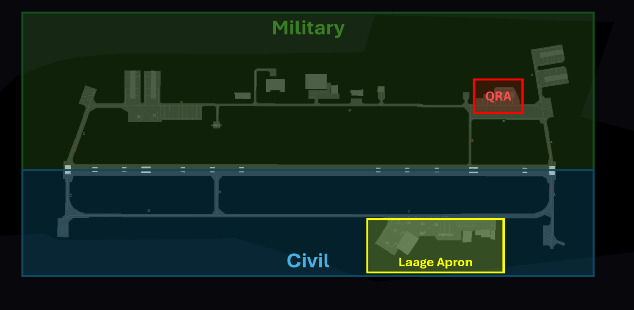](https://knowledgebase.vatsim-germany.org/uploads/images/gallery/2024-03/chrome-uyi4dxckwl.png) ### Control Zone There are two mandatory reporting points for VFR traffic entering and exiting the control zone: - North: November - South: Sierra There are also VFR Jet arrivals and VFR Jet departures that are used for military Jets. The Jet arrival consists of one mandatory reporting point outside the CTR and its respected Initial point in front of the runway. Jets will enter Laage CTR via an Entry at 1700 ft and up to 300 kt.It’s important to remember that Jets on the VFR Jet arrival will overfly the airport at 1700 ft to make an Overhead Approach Maneuver to the south and then join the final as published in the chart!
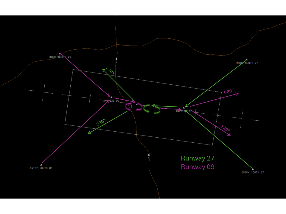 Jets following the VFR Jet departure out of runway 27 will turn right heading 310° or left heading 230° after departure. Jets departing out of runway 09 will fly runway heading until overflying the Initial point of runway 27 and then turn left heading 060° or right heading 120°. Jets will normally leave the CTR to the top. ### Ground Movements Laage airport is split into a civilian and a military part, all facilities, and taxiways south of runway 27/09 are civilian and north of the runway are military. Traffic should use their appropriate taxiways and helipads (Helipad M for Military and Helipad Z for Civilian). Arriving traffic may also be advised to vacate the runway onto the appropriate side. #### Taxi instructions - Every taxi instruction can only be issued by Laage Tower - Procedures between Tower and Apron: - Arriving traffic will be instructed to taxi via Z and contact Laage Apron ("Taxi via Z, contact Apron 121.950") - Departing traffic will push onto Z and contact Tower as soon as it's ready for taxi. - Only Laage Apron will assign parking positions for civilian traffic! - Military traffic should not be instructed to taxi to a specific parking position. - Larger military transport aircraft (A400M, C130, C17,…) should park on Stand 01 or 02 #### Restrictions - **Taxiway A** - North of the runway: maximum width 17,5 m - **Taxiway B** - South of the runway: maximum width 20 m - North of the runway: maximum width 12 m - **Taxiway C** - South of the runway: maximum width 20 m - **Taxiway Z** - Between parking position 4B and the westerly apron: maximum width 20 m - Between the westerly apron and taxiway C: maximum width 16 m ### Quick Reaction Alert (QRA) The QRA for the eastern part of the German Airspace is stationed in the northeast of the Airport and is a closed-up area inside the airport. In case of a scramble Laage Tower needs to inform Laage Radar and should clear the runway to avoid any delays for the QRA. The QRA will prefer runway 27 to reduce taxi time and can be expected to leave the CTR to the top. Laage Tower should hand off the QRA to Laage Radar when airborne.Scramble and other Special operations are only authorized to be performed by members of a VSOA! Non-VSOA members performing special operations should always be reported to a VATSIM Supervisor
### Arriving Traffic Arriving traffic will be transferred by Laage Radar or Bremen Radar when established on the final. Laage Precision will maintain Radio contact with the aircraft performing a PAR until landed. Laage Tower should inform Laage Precision if the runway is clear and the aircraft performing the PAR is cleared to land. #### Approach types For civil traffic, the ILS/LOC Z approach or the RNAV(GPS) approach will be used on both runways. Additionally, there are ILS/LOC Y, SRA, PAR and TACAN approaches available which will be used by military traffic. Laage Precision will maintain Radio contact with aircraft performing a PAR or SRA until landed. Laage Tower should inform Laage Precision if the runway is clear and the aircraft performing the PAR/SRA is cleared to land. ### Departing traffic Laage Tower shall transfer departing traffic to the next station when airborne. If Laage Radar is only, departing traffic shall be transferred to Laage Radar initially.**Every IFR departure from ETNL requires a departure release from both ETNL APP and Bremen Radar prior issuing a takeoff clearance!**
The preferred runway at Laage is runway 27. Laage Tower is responsible for all military traffic and should handle IFR clearances of military traffic. Military IFR Traffic leaving the airport (No IFR Pattern) shall only receive IFR clearances after coordination with EDWW sector Müritz! ### Low Visibility Operations At Laage, only CAT I approaches are possible. Departures are allowed to take off if the following minima are met:| **Runway** | **Takeoff Minima** | **Condition** |
| 09/27 | 400 m RVR | During Day |
| 800 m RVR | During Night |
**Laage Radar shall inform Bremen ACC sector Müritz about the opening and closing of AoR Laage immediately!**
### Procedures #### Arriving traffic - Bremen Radar shall clear traffic descending to FL70 direct to LAG or on a suitable heading. The traffic needs to be coordinated individually between EDWW and ETNL APP (see "Radar Handover").The colour state is only to be used for military traffic. For civil traffic only the ATIS letter and RWY should be used instead. The forecast is announced as the second colour state in the METAR, e.g.: ETNL 301920Z 01003KT 9999 FEW280 18/11 Q1020 BLU+ BLU **From colour state green onwards (IMC), full transmission of the MET Report is required (wind, visibility, special weather, ceiling, QNH)**, e.g.: “Colour state green, wind 250° 9 kts, visibility 4500 m, light rain, clouds overcast 800 ft, QNH 1011”
[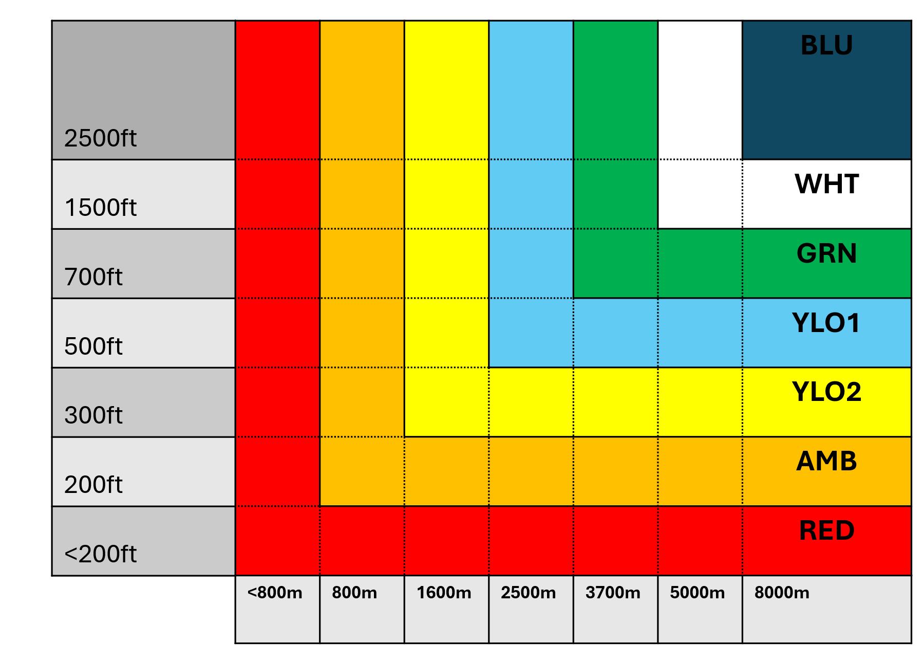Further information about colour state is avilable here.](https://knowledgebase.vatsim-germany.org/link/1489#bkmrk-airfield-color-state)Radar/Radar = radar vectored PAR approach Radar to visual = radar vectored visual approach Radar to ILS = radar vectored ILS approach ...
#### Radar Handover Coordination Next the traffic needs to be coordinated with ETNL APP. For this a so-called Radar Handover is performed.Note: Every aircraft, no matter military or civil, shall be coordinated between EDWW and ETNL APP.
**Example:** (🎧 = MRZ, 📡 = ETNL APP) > 🎧: "Laage Radar, Müritz." > > 📡: "Go ahead! > > 🎧: "Radar Handover, TITANT, 18 NM, southeast LAG TACAN." > > 📡: "Identified!" > > 🎧: "Single Eurofighter, inbound LAG, descending to FL70 for Radar/Radar approach." > > 📡: "Turn right heading 070, descend to altitude 4000 ft, (contact Laage Radar 123.300)." > > 🎧: "Consider! (<initials>)" > > 📡: "(<initials>)" Laage Radar may also accept the current conditions if required (in this example DCT LAG, FL70). After the Radar Handover coordination has been completed, Bremen Radar shall instruct the entry conditions to the pilot and transfer the aircraft as soon as possbile to APP.| **Station** | **Frequency** | **Login** | **SI** | **Anmerkung** |
| Tower | 135.155 | ETNS\_TWR | NST | -- |
| Radar | 123.300 | ETNS\_APP | NSR | -- |
| Precision | 118.555 | ETNS\_P\_APP | NSP | -- |
**If Hohn Radar is offline, Schleswig Radar (ETNS APP) will take over full responsibility for AoR Hohn and top-down responsibilities at ETNH. Therefore, Schleswig Radar shall consult the SOP of Hohn before connecting to the Vatsim network.**
# Tower #### Control Zone - D(HX) from GND to 2600 ft - VRPs: Whiskey and November - There are also VFR Jet arrivals that are used for military Jets. The Jet arrivals consist of two mandatory reporting points each. - For arrivals to runway 04, Entry West will be used. For arrivals to runway 22, Entry East will be used.It’s important to remember that Jets on the VFR Jet arrival will overfly the airport at 1500 ft to make an Overhead Approach Maneuver to the south and then join the final as published in the chart!
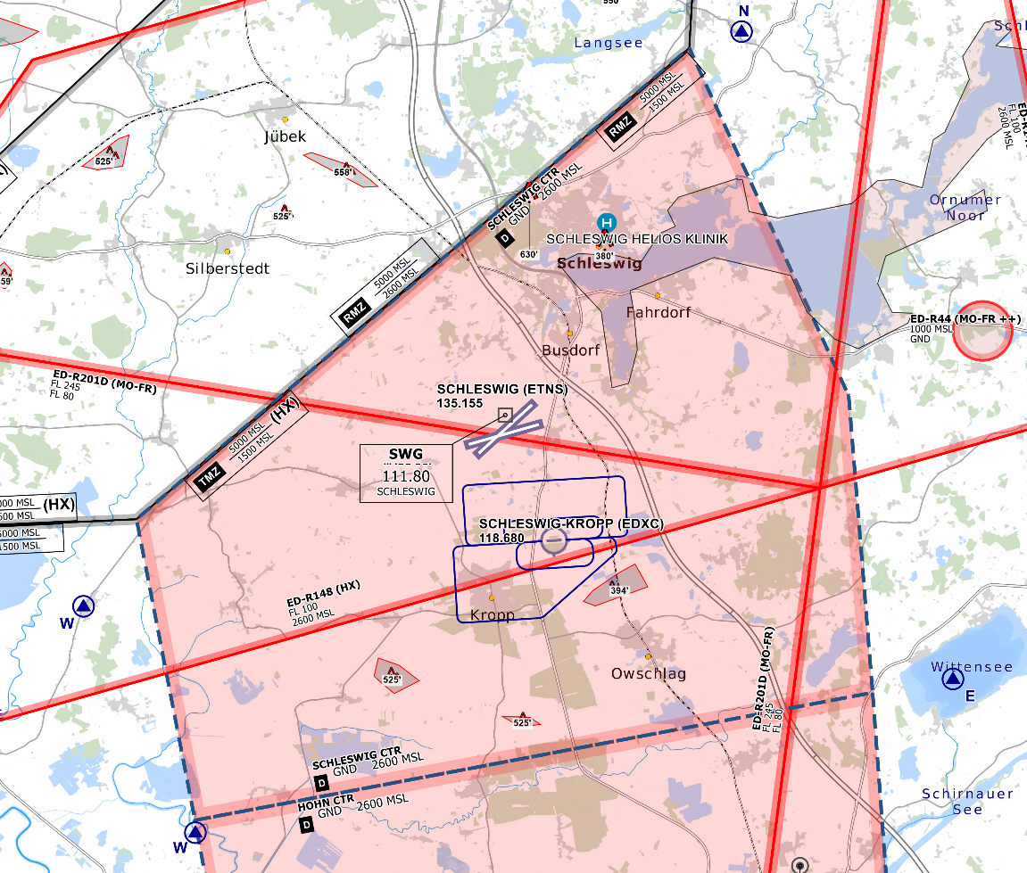*CTR Schleswig - © [openflightmaps.org](https://www.openflightmaps.org/)* #### Ground Movements ##### Parking Positions Schleswig consists of multiple aprons and shelter areas. Schleswig Tower should only instruct aircraft to taxi to the apron/area. ##### Taxi Instructions Schleswig Tower doesn’t need to provide detailed taxi instructions to military traffic if there is no conflicting traffic. Visitors from other squadrons (home squadron is TaktLwg 51) or civilian traffic should receive full taxi instructions. ##### Runways Schleswig has two intersecting runways. Runway 22/04 is used for all aircraft and Runway 25/07 is only used by UAVs. #### Departing Traffic Schleswig Tower should inform departing traffic about current weather conditions. In the case of military traffic, the colour code is sufficient.**Schleswig Tower shall only issue IFR clearances after coordination with EDWW sector Eider (EID)!**
**Every IFR departure from ETNS requires a departure release from both ETNS APP and Bremen Radar before issuing a takeoff clearance!**
##### SID-Assignments - Operational Instrument Departures (OIDs) are used (ETNS1A for RWY 04 and ETNS2B for RWY 22), initial climb 4000 FT. #### Arriving Traffic ##### Approach Types Schleswig is equipped with a TACAN, RNP and ARA/IAA (Internal Aids Approach) approach onto runway 04 and runway 22. The ARA/IAA approach can only be flown by aircraft having the required equipment on board (e.g. Tornado) There are also PAR and SRA approaches available on both runways. Schleswig Precision will maintain Radio contact with the aircraft performing a PAR until landed. Schleswig Tower should inform Schleswig Precision if the runway is clear and the aircraft performing the PAR is cleared to land. #### Hohn (ETNH) Schleswig Tower shall inform Hohn Tower about the activation and closure of CTR Schleswig. #### Schleswig-Kropp (EDXC) Schleswig-Kropp is an uncontrolled airfield located south inside the CTR of ETNS. Close coordination between Kropp Radio and Schleswig Tower is required for traffic from/to EDXC. During the activity of ETNS CTR, the southern traffic circuit at EDXC shall only be used. # Radar ### Area of Responsibility Schleswig Radar is responsible for departing and arriving traffic from/to ETNS. When online, Schleswig Radar activates its delegated AoR within the Bremen ACC sector Eider (EID). Full responsibility is delegated to Schleswig Radar for this airspace. 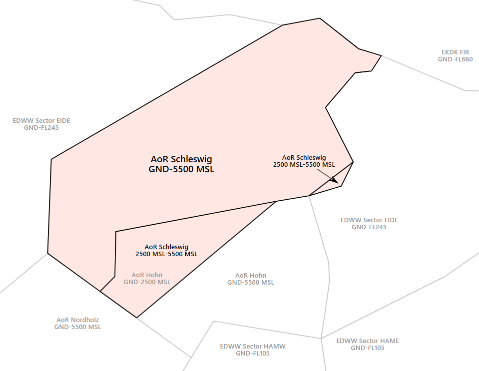*AoR Schleswig***Schleswig Radar shall inform Bremen ACC sectors EID and Hohn Radar (ETNH APP) about the opening and closing of AoR Schleswig immediately!**
**If Hohn Radar is offline, Schleswig Radar (ETNS APP) will take over full responsibility for AoR Hohn and top-down responsibilities at ETNH. Therefore, Schleswig Radar shall consult the SOP of Hohn before connecting to the Vatsim network.**
### Airspace  Hohn/Schleswig is equipped with a TMZ and RMZ. This will ensure that VFR traffic in the vicinity of the aerodrome is known to Hohn/Schleswig Radar. The RMZ will only be used by traffic not equipped with a transponder (not applicable in Vatsim). Traffic within the TMZ of Hohn/Schleswig shall monitor Schleswig Radar's frequency and squawk 4476. This traffic is not required to make an initial call to ATC. Still, ATC may contact this traffic when required (e.g. traffic information about IFR traffic). ### Procedures #### Arriving Traffic - Arriving traffic is always coordinated individually between Bremen Radar, Hohn Radar and Schleswig Radar ("Radar Handover") - It's expected that Schleswig Radar accepts or otherwise states the sector entry conditions during coordination. #### Departing Traffic - Departing IFR traffic will be transferred from Schleswig Tower to Schleswig Radar initially. - Schleswig Radar is responsible for verifying mode C readout and identifying the departing aircraft - Usually, Schleswig Radar shall coordinate a further climb with EDWW before departure release or coordinate a general release of the climb. Preferably, this coordination is combined with IFR clearance or departure release. If no further climb is coordinated, departing IFR traffic leaving the AoR shall be transferred to Bremen Radar after identification. ### Approach Types #### Runway 04 - TACAN - RNP - ARA/IAA (only if aircraft has required equipment, e.g. Tornado) - SRA - PAR #### Runway 22 - TACAN - RNP - ARA/IAA (only if aircraft has required equipment, e.g. Tornado) - SRA - PAR ### Schleswig Precision - Is only responsible for PAR approaches - Traffic is controlled by a special radar system - Schleswig Radar will issue an initial vector leading to the final before performing a radar handover to Schleswig Precision - Only one aircraft at a time shall be on the frequency of Schleswig Precision # ETNT - Wittmundhafen # Overview ### Wittmundhafen Overview Wittmundhafen is a military airfield in the northwest of Germany which is home to the Taktische Luftwaffengeschwader 71 „Richthofen“ by the German Air Force. For the most part, Wittmundhafen handles Military Jet traffic. Charts can be found in the [MIL AIS](https://www.milais.org/). - VFR Charts: Library → Under Publication select “[GEMIL FLIP VAD](https://www.milais.org/publications.php)” → Wittmundhafen - IFR Charts: Library → CENOR FLIP→ [Aerodromes ](https://www.milais.org/cenor.php?ZnJtaWQ9MA==)→ Wittmundhafen ### Wittmundhafen ATC Stations| **Station** | **Frequency** | **Login** | **SI** | **Anmerkung** |
| Tower | 118.730 | ETNT\_TWR | NTT | -- |
| Radar | 123.600 | ETNT\_APP | NTR | -- |
**If Nordholz Radar is offline, Wittmund Radar (ETNT APP) will take over full responsibility for AoR Nordholz and top-down responsibilities at ETMN. Therefore, Wittmund Radar shall consult the SOP of Nordholz before connecting to the Vatsim network.**
# Tower #### Control Zone - D(HX) from GND to 2500 ft - VRPs: November, Sierra - There are also VFR Jet arrivals that are used for military Jets. The Jet arrival consists of one mandatory reporting point outside the CTR and its respected Initial point in front of the runway. Jets will enter Wittmund CTR via an Entry at 1500 ft and up to 300 kt and fly over the respected Initial point. - For arrivals to runway 07, Entry West will be used. For arrivals to runway 25, Entry East will be used. - The published jet pattern is situated north of runway 07/25 - There are no VFR Jet departures at Wittmund. Military Jets flying VFR should leave the CTR to the top on runway track.It’s important to remember that Jets on the VFR Jet arrival will overfly the airport at 1500 ft to make an Overhead Approach Maneuver to the north and then join the final as published in the chart!
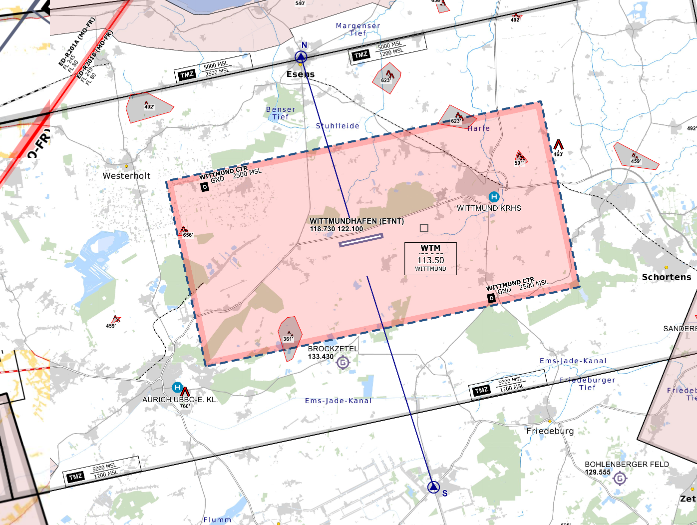*CTR Wittmundhafen - © [openflightmaps.org](https://www.openflightmaps.org/)* #### Ground Movements ##### Parking Positions Wittmundhafen consists of multiple Aprons with multiple Hangars. Wittmund Tower should only instruct aircraft to taxi to the apron. ##### Taxi Instructions Wittmund Tower doesn’t need to provide detailed taxi instructions to military traffic if there is no conflicting traffic. #### Departing Traffic Wittmund Tower should inform departing traffic about current weather conditions. In the case of military traffic, the colour code is sufficient.**Wittmund Tower shall only issue IFR clearances after coordination with EDWW sector Eider West (EIDW)!**
**Every IFR departure from ETNT requires a departure release from both ETNT APP and Bremen Radar before issuing a takeoff clearance!**
##### SID-Assignments - Usually, Operational Instrument Departures (OIDs) are used (NT107 and NT125), initial climb by ATC. ##### Quick Reaction Alert (QRA) The QRA for the northern part of the German Airspace is stationed in the east of the airport and is a closed-up area inside the airport. In case of a scramble Wittmund Tower needs to inform Wittmund Radar and should clear the runway to avoid any delays for the QRA. The QRA will prefer runway 25 to reduce taxi time and can be expected to leave the CTR to the top. Wittmund Tower should hand off the QRA to Wittmund Radar when airborne.Scramble and other Special operations are only authorized to be performed by members of a VSOA! Non-VSOA members performing special operations should always be reported to a VATSIM Supervisor.
#### Arriving Traffic ##### Approaches Types Wittmundhafen is equipped with a TACAN approach onto runway 07 and an ILS and TACAN approach onto runway 25. There are also PAR and SRA approaches available on both runways. Wittmund Radar will maintain Radio contact with the aircraft performing a PAR or SAR until landed. Wittmund Tower should inform Wittmund Radar if the runway is clear and the aircraft performing the PAR/SRA is cleared to land. # Radar ### Area of Responsibility Wittmund Radar is responsible for departing and arriving traffic from/to ETNT as well as for IFR traffic at EDWE and EDWI. When online, Wittmund Radar activates its delegated AoR within the Bremen ACC sector Eider West (EIDW). Full responsibility is delegated to Wittmund Radar for this airspace. 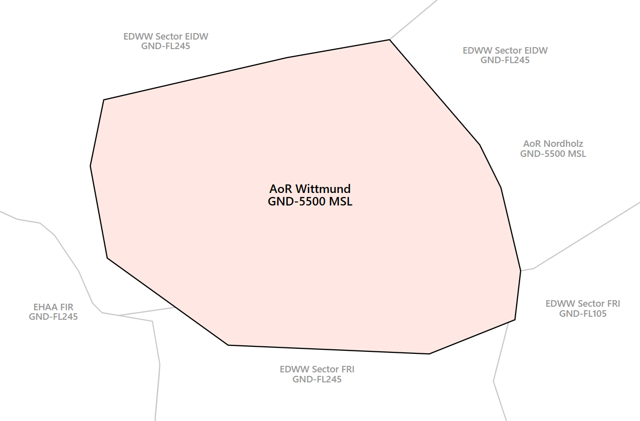*AoR Wittmund***Wittmund Radar shall inform Bremen ACC sectors EIDW, FRI and Nordholz Radar (ETMN APP) about the opening and closing of AoR Wittmund immediately!**
**If Nordholz Radar is offline, Wittmund Radar (ETNT APP) will take over full responsibility for AoR Nordholz and top-down responsibilities at ETMN. Therefore, Wittmund Radar shall consult the SOP of Nordholz before connecting to the Vatsim network.**
### Airspace 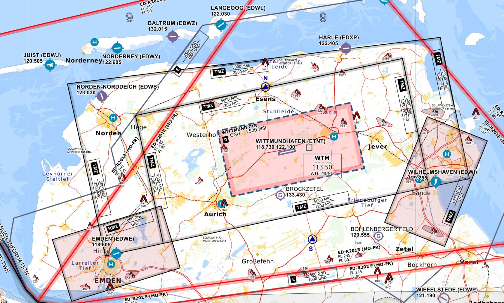 Wittmundhafen is equipped with a TMZ and RMZ. This will ensure that VFR traffic in the vicinity of the aerodrome is known to Wittmund Radar. The RMZ will only be used by traffic not equipped with a transponder (not applicable in Vatsim). Traffic within the TMZ of Wittmundhafen shall monitor Wittmund Radar's frequency and squawk 4472. This traffic is not required to make an initial call to ATC. Still, ATC may contact this traffic when required (e.g. traffic information about IFR traffic). ### Procedures #### Arriving Traffic - Arriving traffic is always coordinated individually between Bremen Radar, Nordholz Radar and Wittmund Radar ("Radar Handover") - It's expected that Wittmund Radar accepts or otherwise states the sector entry conditions during coordination. #### Departing Traffic - Departing IFR traffic will be transferred from Wittmund Tower to Wittmund Radar initially. - Wittmund Radar is responsible for verifying mode C readout and identifying the departing aircraft - Usually, Wittmund Radar shall coordinate a further climb with EDWW before departure release or coordinate a general release of the climb. Preferably, this coordination is combined with IFR clearance or departure release. If no further climb is coordinated, departing IFR traffic leaving the AoR shall be transferred to Bremen Radar after identification. #### EDWE Traffic - Wittmund Radar is responsible for controlling traffic from/to Emden (EDWE). - Traffic from/to the south will be transferred according to the [LoP EDWW ACC](https://knowledgebase.vatsim-germany.org/books/bremen-fir-edww/page/lop-bremen-acc) (between EIDW and FRI) - Traffic from/to the south on Helicopter procedures will be coordinated individually between Wittmund Radar and EDWW ACC sector EIDW - Procedures via JUIST shall be used by helicopters only - Emden is uncontrolled, therefore Wittmund Radar will not provide ATC service for traffic below controlled airspace - IFR clearances will be coordinated between Emden Information and Wittmund Radar - Wittmund Radar shall inform Emden Information about every IFR inbound traffic at least 5 minutes prior landing - Check DFS AIP IFR for published approach and departure procedures! #### EDWI Traffic - Wittmund Radar is responsible for controlling traffic from/to Wilhelmshaven "JadeWeserAirport" (EDWI). - Traffic from/to the south will be transferred according to the [LoP EDWW ACC](https://knowledgebase.vatsim-germany.org/books/bremen-fir-edww/page/lop-bremen-acc) (between EIDW and FRI) - Wilhelmshaven is uncontrolled, therefore Wittmund Radar will not provide ATC service for traffic below controlled airspace - IFR clearances will be coordinated between Wilhelmshaven Information and Wittmund Radar - Wittmund Radar shall inform Wilhelmshaven Information about every IFR inbound traffic at least 5 minutes prior landing - Check DFS AIP IFR for published approach and departure procedures! ### Approach Types #### Runway 07 - RNP - TACAN - SRA - PAR #### Runway 25 - ILS - RNP - TACAN - SRA - PARSince **Wittmund Precision is currently not implemented on VATSIM**, PAR approaches can only be conducted if traffic levels permit - if necessary, Wittmund Radar can coordinate with civilian ATC to keep other inbound traffic outside of the airspace while a PAR approach is taking place; whether this is possible, however, depends on the current workload of civilian ATC.
# ETNW - Wunstorf # Overview ### Wunstorf Overview Wunstorf is a military airfield in the northwest of Germany which is home to the "Lufttransportgeschwader 62" by the German Air Force. For the most part, Wunstorf handles Military Transporter traffic (e.g. Airbus A400M). Charts can be found in the [MIL AIS](https://www.milais.org/). - VFR Charts: Library → Under Publication select “[GEMIL FLIP VAD](https://www.milais.org/publications.php)” → Wunstorf - IFR Charts: Library → CENOR FLIP→ [Aerodromes ](https://www.milais.org/cenor.php?ZnJtaWQ9MA==)→ Wunstorf ### Wunstorf ATC Stations| **Station** | **Frequency** | **Login** | **SI** | **Anmerkung** |
| Tower | 132.055 | ETNW\_TWR | NWT | -- |
| Radar | 124.655 | ETNW\_APP | NWR | -- |
**If Bückeburg Radar (ETHB APP) is offline, Wunstorf Radar will take over full responsibility for AoR Bückeburg and top-down responsibilities at ETHB. Therefore, Wunstorf Radar shall consult the SOP of Bückeburg before connecting to the Vatsim network.**
# Tower #### Area of Responsibility Whenever Wunstorf Tower is active, ATS in the western part of Hannover CTR is delegated to Wunstorf TWR (or Wunstorf APP) depending on the runway direction at EDDV and the weather conditions at EDDV and ETNW.Wunstorf TWR shall inform Hannover TWR immediately about the opening and closure of Wunstorf CTR. Both TWRs shall terminate the status of the ATS delegation (see below).
##### EDDV RWYs 09 [](https://knowledgebase.vatsim-germany.org/uploads/images/gallery/2024-10/msedge-ffmuh1iaag.png)| Status | Condition | Sector | Responsibility |
| Victor 09 | If CTR Hannover is VMC **and** Wunstorf airport is VMC. | W, X & Z | Wunstorf TWR |
| Full CTR | If CTR Hannover is IMC **or** Wunstorf airport are IMC. | W, X & Z | Hannover TWR |
| Status | Condition | Sector | Responsibility |
| Victor 27 | If CTR Hannover is VMC **and** Wunstorf airport is VMC. | Y & Z | Wunstorf TWR |
| West to APP | If Wunstorf APP is active **and either** CTR Hannover is IMC **or** Wunstorf airport is IMC | Y | Wunstorf APP |
| Z | Hannover TWR | ||
| Full CTR | If Wunstorf APP is not active **and either** CTR Hannover is IMC **or** Wunstorf airport is IMC | Y & Z | Hannover TWR |
RWY 02/20 is closed for single and double-seated military jet aircraft.
#### Taxiways and Aprons Wunstorf Tower shall provide full taxi instructions including all taxiways. Intersection departures shall only be assigned after an explicit pilot's request. Traffic departing from RWY 20 shall be guided via runway intersection N2. By default, arriving aircraft will park at the main apron north of the taxiway N. Wunstorf shall assign a parking position to the aircraft. ##### Taxiway Restrictions At Wunstorf, the following taxiway restrictions exist:| Restricted Taxiway | Restriction |
| N1, N2, N3, N4 | Max. wingspan 36 m or max. wingspan 52 m with an outer main gear wheel span of up to 9 m |
| Closed for aircraft with low-mounted jet engines | |
| E (between RWY 26 and E1), E (between RWY 02 and E2), E2 | Max. wingspan 36 m and max. wheelbase 18 m |
| E (between E1 and E2) | Max. wingspan 15 m |
**Wunstorf Tower shall only issue IFR clearances after coordination with EDWW sector Hannover (HAN)!**
**Every IFR departure from ETNW requires a departure release from both ETNW APP and Bremen Radar before issuing a takeoff clearance!**
**Note:** Local IFR traffic staying within AoR Wunstorf only needs to be coordinated between Wunstorf TWR and Wunstorf APP, both for IFR clearance and departure release.**IFR departures from RWY 08 will not enter AoR Wunstorf. Whenever possible, this traffic shall be transferred to EDWW sector HAN directly. This procedure, however, shall be cross-checked with Bremen Radar before takeoff clearance.**
##### SID Assignment Departing IFR traffic shall be guided via the following departure routes.| Runways | OIDs | SIDs | ||||
| CEL | NIE | SAS | ROBEG | VAXEV | ||
| 08 | NW 308 | CEL 1A | NIE 1A | SAS 1A | ROBEG 1A | VAXEV 1A |
| 26 | NW 326 | CEL 1B | NIE 1B | --- | ROBEG 1B | VAXEV 1B |
| 02 | NW 102 | --- | --- | --- | --- | --- |
| 20 | NW 120 | --- | --- | --- | --- | --- |
**The initial climb for all SIDs is 4000 ft.** All SIDs consist of speed restrictions, therefore Wunstorf TWR shall use the phrase "climb via SID" when issuing the IFR clearance.
The initial climb for all OIDs is subject to individual coordination with Wunstorf APP/Bremen Radar. NW102 is only available for aircraft CAT A and B. NW120 is only available for aircraft CAT A-D. ##### Low Visibility Takeoffs (LVTO) RWY 08/26 is suitable for conducting low-visibility take-offs with a minimum runway visual range of 125 m. #### IFR Arrivals Arriving traffic will be transferred by Wunstorf Radar or Bremen Radar when established on the final. In case of a PAR or SRA approach, Wunstorf Radar will maintain radio contact with the aircraft performing a PAR or SRA until landed. Wunstorf Tower shall inform Wunstorf Radar if the runway is clear and the aircraft performing the PAR or SRA is cleared to land. ##### Approaches Types Wunstorf is equipped with the following approach types:| Runways | ILS Z (CAT I) | LOC | RNP | TACAN | PAR | SRA |
| 08 | **✔** | **✔** | **✔** | **✔** | **✔** | **✔** |
| 26 | **✔** | **✔** | **✔** | **✔** | **✔** | **✔** |
| 02 | **✔** | **✔** | **✔** | |||
| 20 | **✔** | **✔** | **✔** |
Low visibility approaches are not available at ETNW.
#### VFR Traffic There are two CTR entry and exit procedures for VFR traffic to ETNW: - North: VICTOR 1 - VICTOR 2 - South: SIERRA 1 - SIERRA 2 Additionally, two VFR holding procedures exist at ETNW (north and southeast). [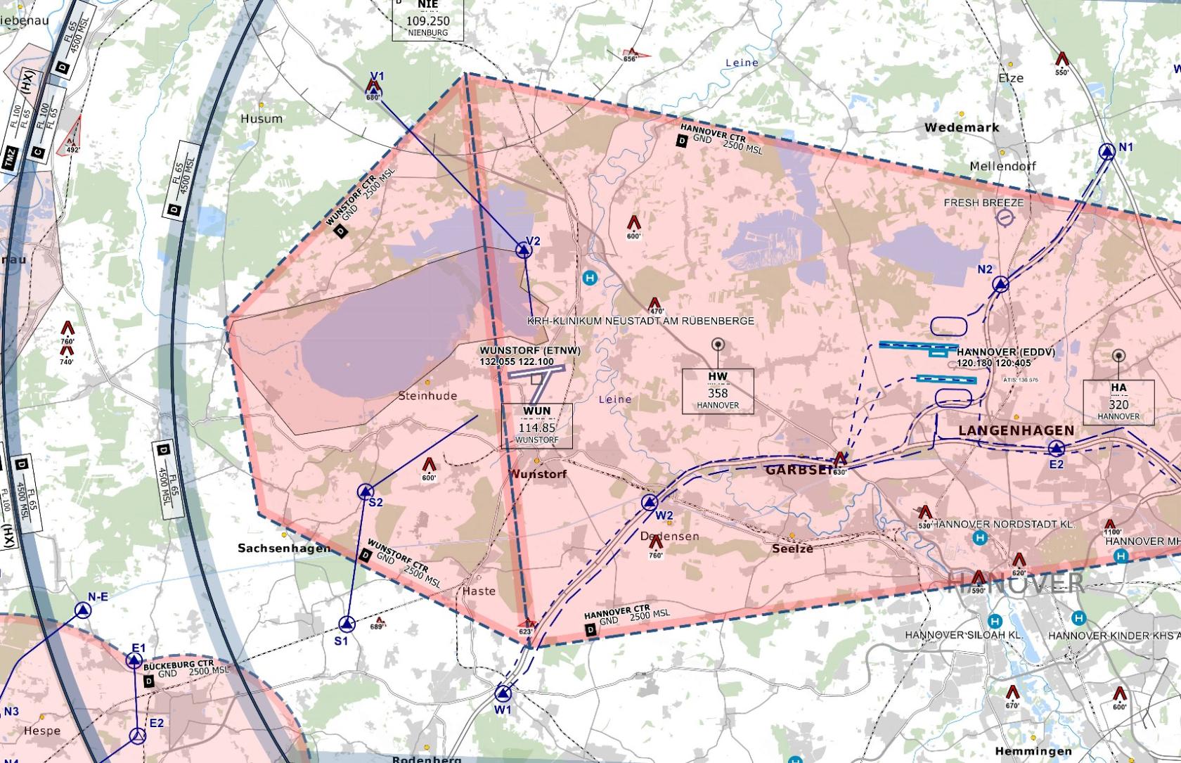](https://knowledgebase.vatsim-germany.org/uploads/images/gallery/2024-10/chrome-7orawp2lng.jpg) *CTR Wunstorf/Hannover - © [openflightmaps.org](https://www.openflightmaps.org/)*VFR traffic between Hannover Tower and Wunstorf Tower shall be coordinated individually.
There are also VFR Jet arrivals/ and VFR Jet departures that are used for military Jets. Military jets will enter the CTR via ENTRY West and then join the respective INITAL points for either RWY 08 or RWY 26. Jets will leave Wunstorf CTR via EXIT WEST.It’s important to remember that Jets on the VFR Jet arrival will overfly the airport to make an Overhead Approach Maneuver to the south and then join the final as published in the chart!
# Radar ### Area of Responsibility Wunstorf Radar is responsible for departing and arriving traffic from/to ETNW. When online, Wunstorf Radar activates its delegated AoR within the Bremen ACC sector Hannover (HAN). Full responsibility is delegated to Wunstorf Radar for this airspace. [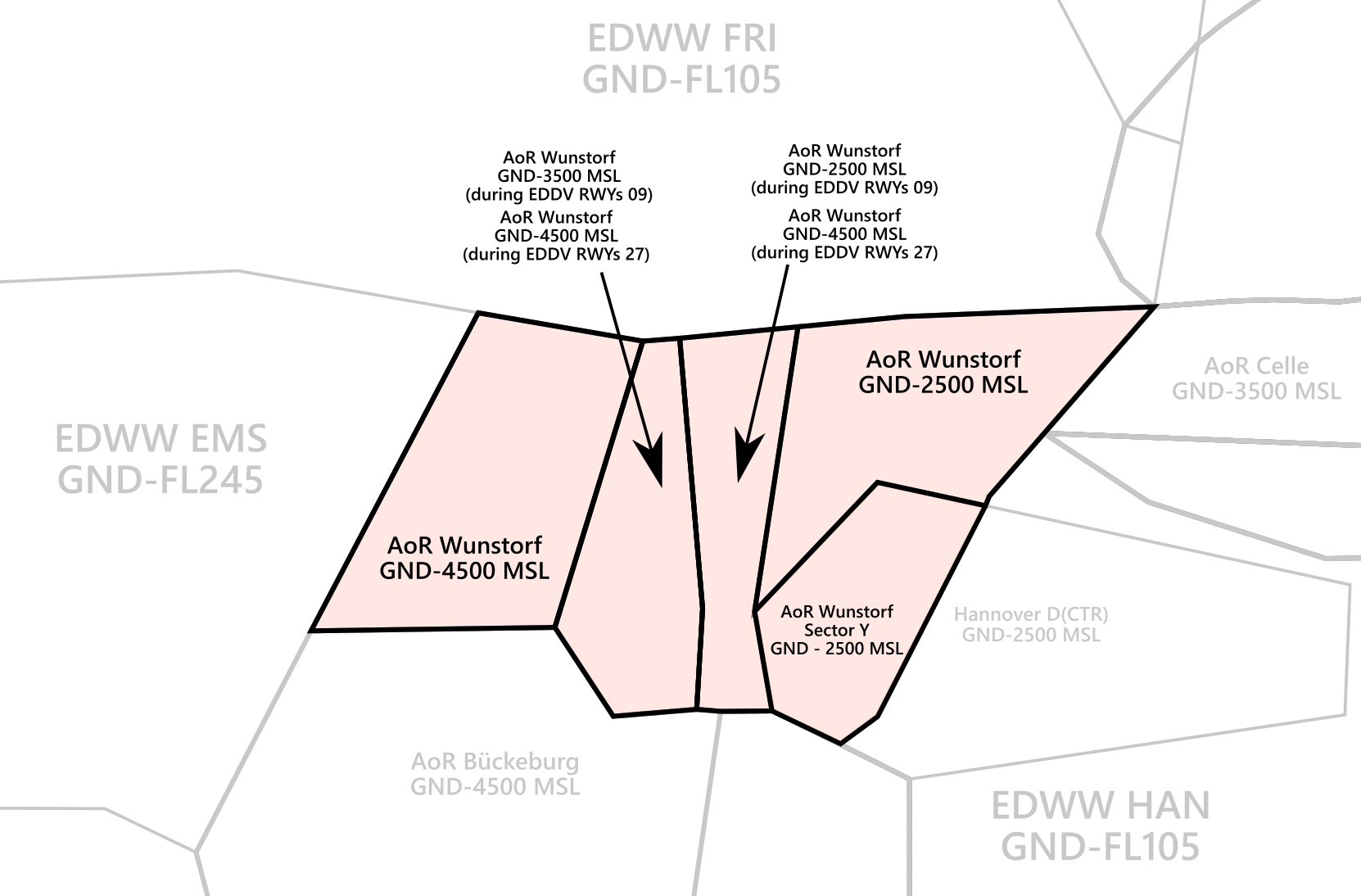](https://knowledgebase.vatsim-germany.org/uploads/images/gallery/2024-10/inkscape-dm0hhrs28k.png) *AoR Wunstorf***Wunstorf Radar shall inform Bremen ACC sectors HAN, FRI and EMS as well as Bückeburg Radar (ETHB APP) and Celle Radar (ETHC APP) about the opening and closing of AoR Wunstorf immediately! Additionally, Wunstorf Radar shall also inform Wunstorf TWR and Hannover TWR.**
**Sub-sectors of AoR Wunstorf are activated depending on the active runways at EDDV. The virtual controller shall always select the active runways at EDDV in Euroscope to load and AoR Wunstorf correctly.**
**Sector Y will only be delegated from Hannover Tower to Wunstorf Radar during EDDV RWYs 27L/R and if either CTR Hannover or Wunstorf airport are IMC** (Status "West to APP", see ETNW Tower SOP)**.** During VMC, sector Y will be delegated to Wunstorf TWR.
**If Bückeburg Radar (ETHB APP) is offline, Wunstorf Radar will take over full responsibility for AoR Bückeburg and top-down responsibilities at ETHB. Therefore, Wunstorf Radar shall consult the SOP of Bückeburg before connecting to the Vatsim network.**
### Procedures #### Arriving Traffic - Arriving traffic is always coordinated individually between Bremen Radar, Bückeburg/Celle Radar and Wunstorf Radar ("Radar Handover") - It's expected that Wunstorf accepts or otherwise states the sector entry conditions during coordination. - IFR traffic approaching on runway 26 shall always be coordinated with EDWW sector Hannover and Hannover Tower as this traffic will leave AoR Wunstorf. Approach clearance may be provided by EDWW sector HAN after coordination. - IFR Traffic approaching on runway 02 shall always be coordinated with Bückeburg Radar as this will temporarily leave AoR Wunstorf. #### Departing Traffic - In most cases, departing IFR traffic will be transferred from Wunstorf Tower to Wunstorf Radar initially. - Wunstorf Radar is responsible for verifying mode C readout and identifying the departing aircraft - Usually, Wunstorf Radar shall coordinate a further climb with EDWW before departure release or coordinate a general release of the climb. Preferably, this coordination is combined with IFR clearance or departure release. If no further climb is coordinated, departing IFR traffic leaving the AoR shall be transferred to Bremen Radar after identification.**IFR traffic departing from RWY 08 will not enter AoR Wunstorf. This traffic shall be transferred from Wunstorf Tower to EDWW sector Hannover directly.** Local IFR traffic shall be coordinated between Wunstorf Radar and Bremen Radar individually.
### Approach Types Wunstorf is equipped with the following approach types:| Runways | ILS Z (CAT I) | LOC | RNP | TACAN | PAR | SRA |
| 08 | **✔** | **✔** | **✔** | **✔** | **✔** | **✔** |
| 26 | **✔** | **✔** | **✔** | **✔** | **✔** | **✔** |
| 02 | **✔** | **✔** | **✔** | |||
| 20 | **✔** | **✔** | **✔** |
Low visibility approaches are not available at ETNW.
Since **Wunstorf Precision is currently not implemented on VATSIM**, PAR approaches can only be conducted if traffic levels permit - if necessary, Wunstorf Radar can coordinate with civilian ATC to keep other inbound traffic outside of the airspace while a PAR approach is taking place; whether this is possible, however, depends on the current workload of civilian ATC.
# ETSH - Holzdorf # OverviewOn Moodle, a non-mandatory SOP Test can be found under [**ETSH - Holzdorf**](https://moodle.vatsim-germany.org/course/view.php?id=85)
### Holzdorf Overview Holzdorf is a military airfield south of Berlin which is home of the Helicopter Wing 64 by the German Air Force. For the most part, Holzdorf handles Helicopter traffic but anconal gets visited by jet and transport aircraft for training patterns. Charts can be found in the [MIL AIS](https://www.milais.org/). - VFR Charts: Library → Under Publication select “[GEMIL FLIP VAD](https://www.milais.org/publications.php)” → Holzdorf - IFR Charts: Library → CENOR FLIP→ [Aerodromes ](https://www.milais.org/cenor.php?ZnJtaWQ9MA==)→ Holzdorf ### Holzdorf ATC Stations| **Station** | **Frequency** | **Login** | **SI** | **Anmerkung** |
| Tower | 130.505 | ETSH\_TWR | SHT | -- |
| Radar | 129.855 | ETSH\_APP | SHR | -- |
It’s important to remember that Jets on the VFR Jet arrival will overfly the airport at 1800 ft to make an Overhead Approach Maneuver to the south and then join the final as published in the chart!
Jets following the VFR Jet departure out of runway 27 will fly runway heading until overflying the Initial point of runway 09 and then turn left towards EXIT NORTH 1 or right towards EXIT SOUTH. 1. Jets departing out of runway 09 will fly runway heading until overflying the Initial point of runway 27 and then turn left towards EXIT NORTH 2 or right towards EXIT SOUTH 2. Jets will remain at 1800 ft until clear of CTR but can also be cleared to leave the CTR to the top. [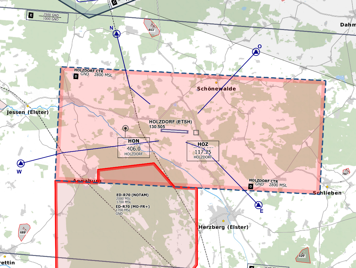](https://knowledgebase.vatsim-germany.org/uploads/images/gallery/2022-09/eddb-ctr.png)*CTR Holzdorf - © [openflightmaps.org](https://www.openflightmaps.org/)* *[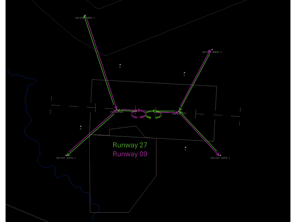](https://knowledgebase.vatsim-germany.org/uploads/images/gallery/2024-05/etsh-vad.png)* *Jet Entries/Exits Holzdorf* #### Ground Movements ##### Parking Positions Holzdorf consists of multiple Ramps and Holzdorf Tower should only instruct aircraft to taxi to a Ramp and not to a specific stand. - Helicopter should park on Ramp 1A, 1B, 1C, 4 and 6 - Aircraft should park on Ramp 4 or Ramp 5 - Ramp 2A and Ramp 2B are part of the maintenance facility - SAR parks on the SAR helipad south of the runway 27/09 ##### Taxi Instructions Holzdorf Tower doesn’t need to provide detailed taxi instructions to military traffic if there is no conflicting traffic. Visitors from other squadrons (home squadron is HSG 64) or civilian traffic should receive full taxi instructions. [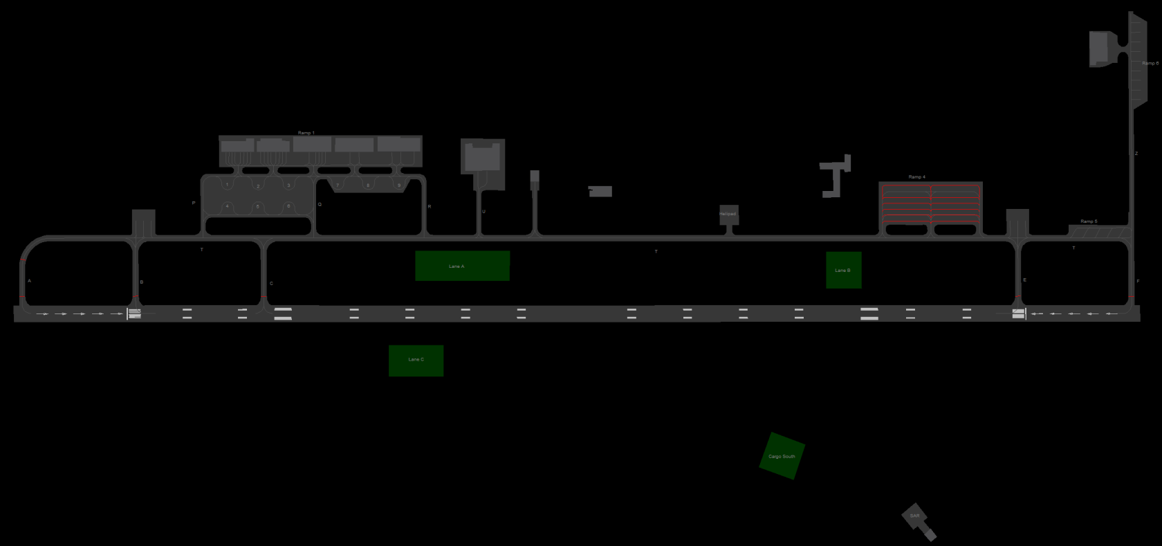](https://knowledgebase.vatsim-germany.org/uploads/images/gallery/2024-05/etsh-gnd.png) ##### Helicopter Lanes and Pads Holzdorf is equipped with 3 Helipads (Ramp 6, T and SAR) and 3 Helicopter Lanes. Helicopter Lanes can be regarded as normal grass runways parallel to runway 27/09 that can only be used by helicopters. Taxi instruction from and to Lane C needs to include a runway crossing of runway 27/09. #### Departing Traffic Holzdorf Tower should inform departing traffic about current weather conditions. In the case of military traffic, the colour code is sufficient.**Holzdorf Tower shall only issue IFR clearances after coordination with EDWW sector Berlin Arrival!**
**Every IFR departure from ETSH requires a departure release from both ETSH APP and Bremen Radar before issuing a takeoff clearance!**
##### SID-Assignments - SIDs are named after the last two letters of the ICAO code of Holzdorf, ETSH (SH127 and SH109) - Initial climb clearances for all SIDs is 4000ft (unless otherwise coordinated with DBAS or SHR) #### Arriving Verkehr ##### Approaches Types Holzdorf is equipped with an RNP, TACAN and NDB approach onto runway 09 and an ILS, RNP and TACAN approach onto runway 27. There are also special variations of some approaches for helicopters, these are mostly shorter approaches. There is also a PAR and SRA approach available on both runways. Holzdorf Precision will maintain Radio contact with aircraft performing a PAR or SAR until landed. Holzdorf Tower should inform Holzdorf Precision if the runway is clear and the aircraft performing the PAR/SRA is cleared to land. # Radar ### Area of Responsibility Holzdorf Radar is responsible for departing and arriving traffic from/to ETSH. When online, Holzdorf Radar activates its delegated AoR within Bremen ACC sector Berlin Arrival Süd (DBAS). Full responsibility is delegated to Holzdorf Radar for this airspace. [](https://knowledgebase.vatsim-germany.org/uploads/images/gallery/2022-10/holzdorf-aor.png)*AoR Holzdorf***Holzdorf Radar shall inform Bremen ACC sector DBAS about the opening and closing of AoR Holzdorf immediately!**
### Procedures #### Arriving Traffic - Arriving traffic is always coordinated individually between Bremen Radar or München Radar and Holzdorf Radar ("Radar Handover") - It's expected that Holzdorf accepts or states entry conditions if not suitable during Radar Handover coordination. #### Departing Traffic - Departing IFR traffic will be transferred from Holzdorf Tower to Holzdorf Radar initially. - Holzdorf Radar is responsible to verify mode C readout and to identify the departing aircraft - Usually, Holzdorf Radar shall coordinate a further climb with EDWW before departure release or coordinate a general release of the climb. If no further climb is coordinated, departing IFR traffic leaving the AoR shall be transferred to Bremen Radar after identification. ### Approach Types #### Runway 09 - TACAN - RNP - NDB (Normal) - NDB (Copter) - SRA - PAR #### Runway 27 - TACAN (Normal) - TACAN (Copter) - RNP - ILS (Normal) - ILS (Copter) - SRA - PAR # UNIATIS Codes + vATIS ### UNIATIS| **ATIS URL (one line)** |
| http://uniatis.net/atis.php?arr=$arrrwy($atisairport)&dep=$deprwy($atisairport)&apptype=ILS&info=$atiscode&metar=$metar($atisairport) |
| New Euroscope with up to 4 ATIS sections: replace every $atisairport with $atisairportA, $atisairportB, $atisairportC or $atisairportD |
| **Codes** |
| - Low Visibility Procedure: **&lvp** - Departure Frequency: **&depfreq=XXX.XXX** - For clearance, contact Bremen Radar on **&cdep=XXX.XXX** - possible $apptype values: **ILS, ILSZ, ILSY, RNP** |
| **Instructions:** |
| To use the ATIS codes, just past them at the very end of the ATIS URL. For example: ...$atiscode**&depfreq=XXX.XXX** |