| **Station** | **ID** | **Login** | **Frequency** | **Remarks** | **Endorsement** |
| **ATIS** | XDR | EDDR\_ATIS | 125.480 | -- | -- |
| Ground | DRG | EDDR\_GND | 118.555 | relief station for DRT | [unrestricted](https://moodle.vatsim-germany.org/course/view.php?id=65 "EDDR SOP Test (VATGER moodle)") |
| **Tower** | DRT | EDDR\_TWR | 118.355 | -- | [unrestricted](https://moodle.vatsim-germany.org/course/view.php?id=65 "EDDR SOP Test (VATGER moodle)") |
| Pfalz | PFA | EDDR\_PFA\_APP | 129.675 | -- | unrestricted |
| **Station** | **ID** | **Login** | **Frequency** | **Remarks** |
| Ground | DRG | EDDR\_GND | 118.555 | relief station for DRT |
| **Tower** | DRT | EDDR\_TWR | 118.355 | -- |
| **Via** | **Restrictions** |
| **EDDR** | non-RNAV1 equipped aircraft only |
| **GTQ** ([Grostenquin](https://youtu.be/dSdle8Q26Yc&t=5 "Grostenquin pronunciation (YouTube)")) | -- |
| **IXWIB** | -- |
| **TOMPI** | -- |
Saarbrücken has **very limited apron space**. The airport can only accommodate **six aircraft up to code C** as well as a number of smaller general and business aviation aircraft. Due to this, it may occasionally be necessary to coordinate delays for inbound aircraft when there are a lot of aircraft at the airport simultaneously.
#### Parking positions Parking positions N1 thru N5 and S1 thru S5 are the **same parking positions respectively**, they are **differentiated only be the direction from which they are entered**. Positions labeled N (with the exception of N6) are entered via TWY N (from the North, facing South) while positions labeled S are entered via TWY S (from the South, facing North). The GAT is located in the West of the airport between TWYs B and L. All parking positions at the airport are taxi-out positions. ### Runway operations #### Operating modes There is no preferred operating direction at EDDR and the active operating direction should be chosen based on prevailing weather and traffic conditions. Regardless, tailwind conditions shall never exceed 5 kts. Only RWY 26 is equipped with an ILS, however, the airport is **not equipped nor certified for low visibility operations**. During 08 operations, the **RNP approach** should be used, and during 26 operations, the **ILS Z approach** should be used (the ILS Y is only used for aircraft that are unable to comply with the RNAV-requirements of the ILS Z missed approach). #### Departure releases A departure release by PFA is required in the following situations: - omnidirectional departures - first departure after a missed approach - departure planning to conduct practice maneuvers at EDDR, EDFH, EDRZ, ETAD, ETAR or ETSB or within the EIF or PFA sector - whenever requested by PFA to accommodate operations at EDRZ and/or ETAR #### Reduced runway separation RRS minima may be applied by Saarbrücken Tower, according to the following table:| **Runway** | **preceding CAT 1/CAT 2** **succeeding CAT 1** | **preceding CAT 1/CAT 2** **succeeding CAT 2** | **preceding CAT 3** **succeeding CAT 1/CAT 2/CAT 3** |
| **08/26** | 600m | 1500m | N/A |
| **Reporting point** | **Location** |
| **Echo 1** | highway intersection A6 & A8 |
| **Echo 2** | highway A6 exit Rohrbach |
| **November 1** | highway A8 exit Friedrichsthal |
| **November 2** | Rentrisch village |
| **Sierra** | Sitterswald village |
Labels for all reporting points can be displayed in EuroScope via a TopSky plugin map shortcut: Alt + V
##### Heliports & other airfields 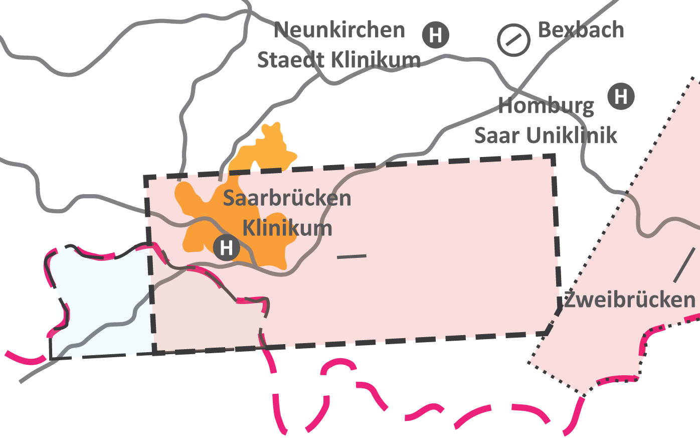The hospital heliport of the **Saarbrücken Klinikum** is located within the CTR, just North of the extended centerline, and requires pilots to contact DRT for clearance. Additionally, the hospital heliports of **Neunkirchen Staedt Klinikum** and **Homburg Saar Uniklinik** as well as the small grass field of **Bexbach** (EDRX) are located just North of the CTR. **Zweibrücken** (EDRZ), which has IFR procedures and thus an RMZ and AFIS, is located just West of the CTR.Labels for all heliports can be displayed in EuroScope via a TopSky plugin map shortcut: Alt + H
# Radar Langen ACC sector Pfalz is responsible for the airspace around EDDR, also including the AFIS field EDRZ and the US military field ETAR, as well as presequencing traffic into various airports adjacent to the sector. In the absense of EDFH\_EIF\_APP, this station also covers the Eifel (EIF) sector, which is responsible for Frankfurth Han(EDFH), Spangdahlem (ETAD) and Büchel (ETSB) top-down.Additionally, controllers will occasionally see low level enroute traffic cross the airspace.| **Station** | **ID** | **Login** | **Frequency** | **Remarks** |
| **Pfalz** | PFA | EDDR\_PFA\_APP | 129.675 | -- |
Sector PFA consists of **various subsectors with differing vertical boundaries**. For the detailed sectorization, please refer to the [sector page](https://knowledgebase.vatsim-germany.org/books/edgg-langen-radar/page/pfa-pfalz-eddr-pfa-app "Langen ACC sector PFA (VATGER Knowledgebase)").
#### Ramstein GCA 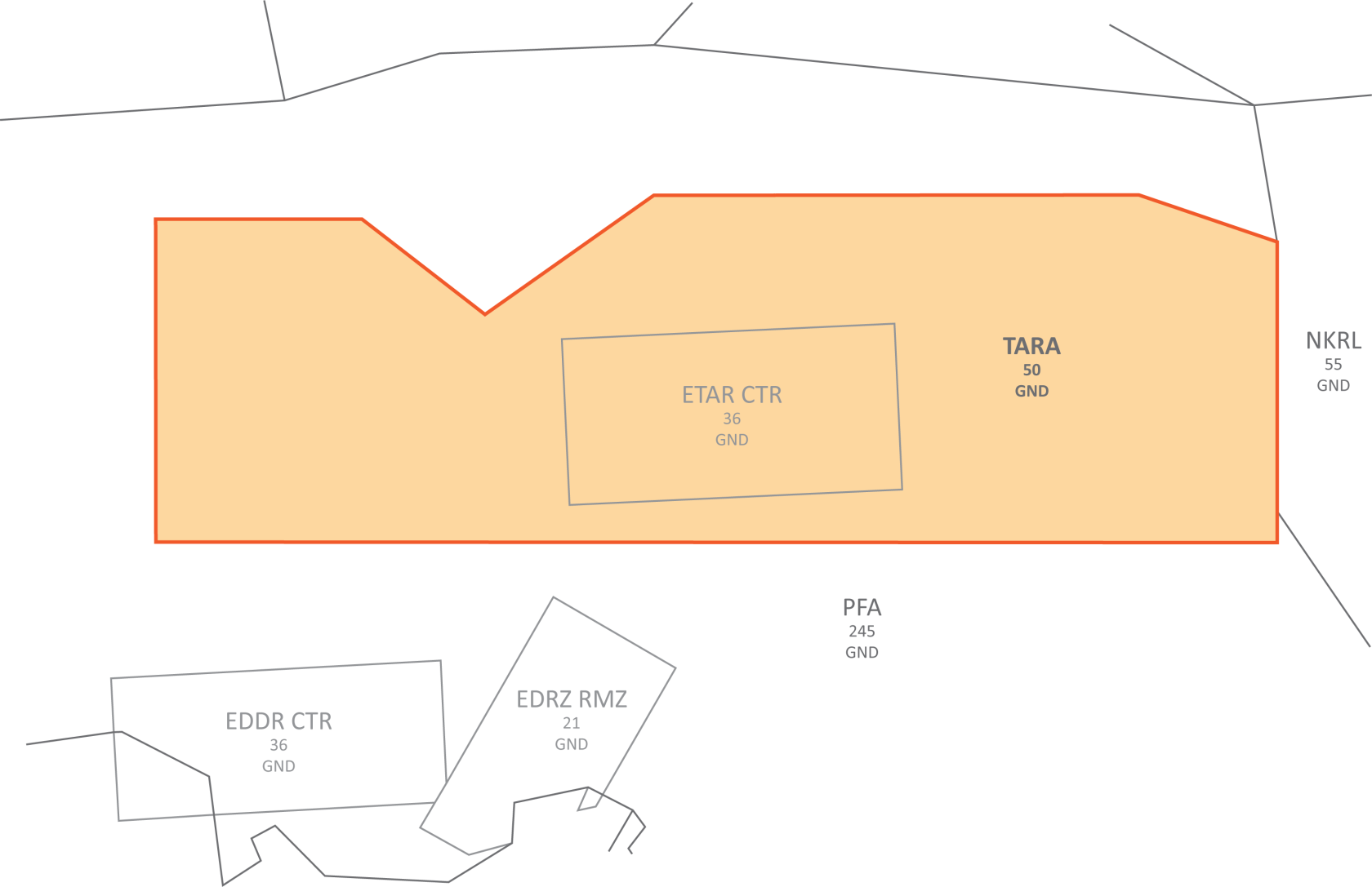Ramstein GCA covers the area around ETAR **up to 5000ft**. Sector **PFA is responsible for maintaining full radar separation** (i.e. 3NM laterally and 1000ft vertically) to the border of this airspace. Various EDDR and EDRZ procedures infringe on this separation, thus **requiring individual coordination of each affected movement**. Additionally, unless otherwise coordinated, IFR departures from ETAR will only have been cleared to the final waypoint of the SID and their clearance limit thus has to be changed to the destination.For more detailed information on Ramstein GCA, please refer to the [ETAR SOP](https://knowledgebase.vatsim-germany.org/books/sops-fir-langen/page/approach-3Bo "ETAR SOP APP (VATGER Knowledgebase)").
### Airspace With the exception of the two D-CTRs EDDR and ETAR, the RMZ EDRZ, and a small section of the TMZ EDFH as well as the TMZ EDDR in delegated French airspace, the entire airspace of sector PFA is **class E below FL100 and class C above FL100**. #### Airports There are **multiple airports of direct relevance** to sector PFA, though they all usually see only low traffic levels. ##### EDDR & EDRZ & ETAR EDDR, EDRZ, and ETAR are the three IFR-capable airports within sector PFA. **EDDR** is a controlled airport with usually very limited IFR and VFR traffic. **EDRZ** is an uncontrolled AFIS field with IFR procedures that usually sees similarly low IFR and VFR traffic levels. **ETAR** is one of the largest and busiest military airports in Germany and the headquarters for the US Air Force in Europe and Africa as well as NATO's Allied Air Command, but on VATSIM it usually sees very low traffic levels.Procedures for these airports, especially EDDR and EDRZ can **conflict with each other**. If necessary, controllers covering sector PFA should ask underlying Tower controllers to hold departures for release until the risk of conflict is gone.
##### EDFH **EDFH** is a controlled airport located in neighboring sector EIF; some of its in- and outbound traffic passes through sector PFA. ##### EDFM & EDRY **EDFM** is a controlled airport and **EDRY** is an uncontrolled AFIS field with IFR approach procedures; both airports are located in neighboring sector NKRL and some of their in- and outbound traffic passes through sector PFA. ##### ELLX **ELLX** is a controlled airport located in neighboring Luxembourg; some of its inbound traffic passes through sector PFA. #### Restricted airspace 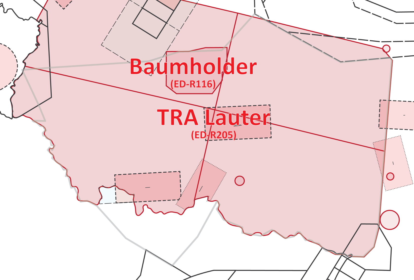Langen ACC EBG 5 is one of Germany's main areas of military air traffic activity, which can have a **significant impact on usual operations**.| **Area** | **Remarks** |
| **Baumholder** (ED-R116) | may prevent some shortcuts for low level enroute traffic as well as inbounds and outbounds of various surrounding airports |
| **TRA Lauter** (ED-R205) | prevents civilian operations above FL95 in parts or the entirety of sector PFA, depending on active segments |
VATGER currently doesn't require controllers to respect real world area activations - thus, controllers who wish to simulate real world area activations must coordinate this with neighboring sectors where necessary. Similarly, controllers are allowed to reject area reservations by a VSOA by informing them via the [area booking thread](https://board.vatsim-germany.org/threads/area-booking-vatger.67465/ "Area Booking Thread (VATGER forums)").
Areas currently active in the real world will automatically be displayed with 15 minutes advance notice through the TopSky plugin TSA function, including actual lateral and vertical limits. Similarly, areas reserved by a VSOA can be manually activated through the TopSky plugin TSA menu.
##### NLFS 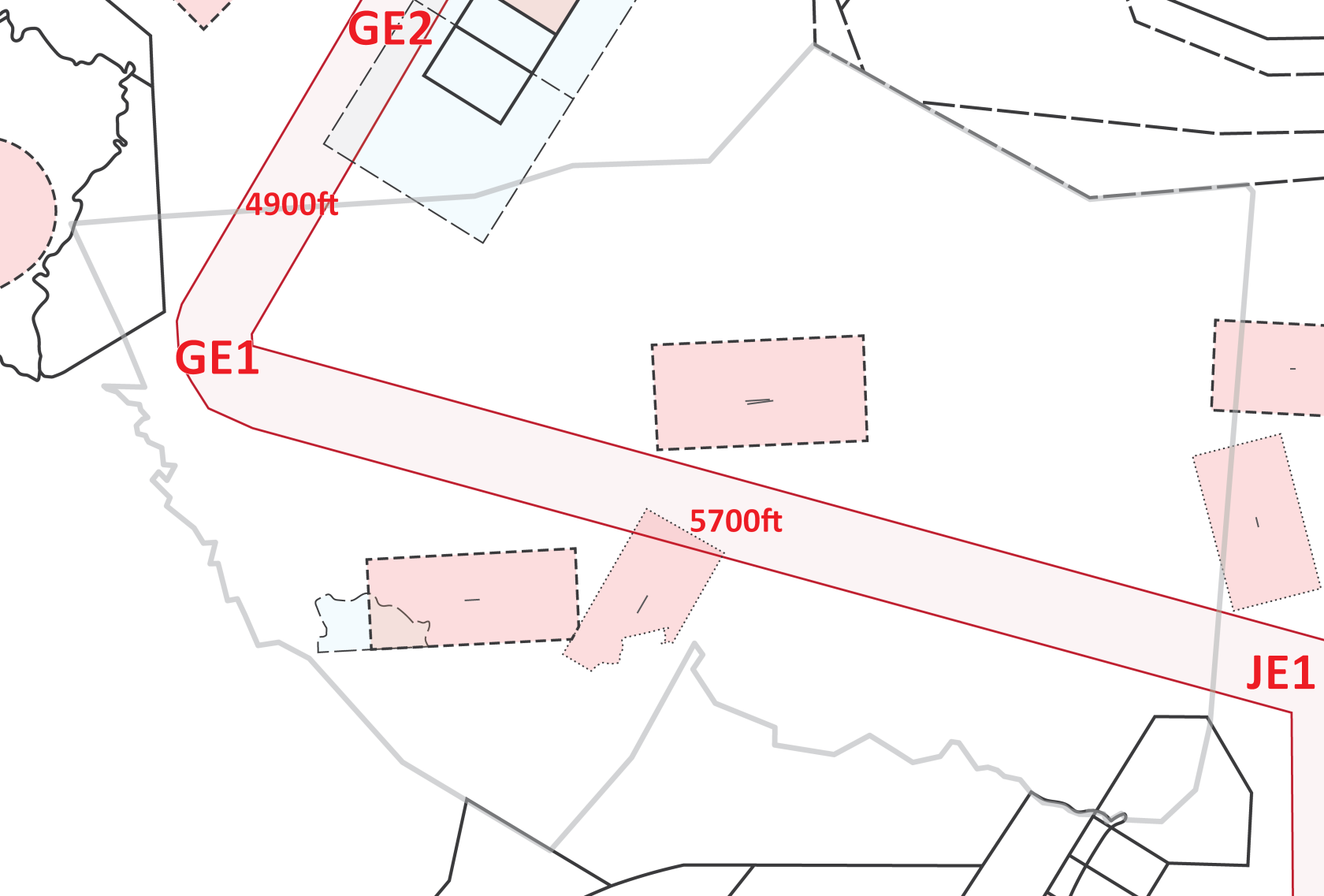ED-R150, also known as the NLFS, is a series of **corridors used for low altitude MIL jet night operations**. A small part of it is located within sector PFA, as depicted on the left. Only certain segments of the NLFS will be active at any given time, depending on the exact mission to be flown by the pilots and all traffic within the NLFS will operate under MVFR.Due to the **significant impact on operations at the airports within sector PFA**, VSOAs are currently restricted from using segment GE1-JE1 and it is highly recommended that controllers don't approve its use as well.
As with any other area reservation by a VSOA, controllers may reject reservations of NLFS segments within their airspace by informing the VSOA via the [area booking thread](https://board.vatsim-germany.org/threads/area-booking-vatger.67465/ "Area Booking Thread (VATGER forums)").
The NLFS, including waypoint labels and segment levels, can be displayed via the TopSky plugin map function: Military -> NLFS
#### VFR airspace 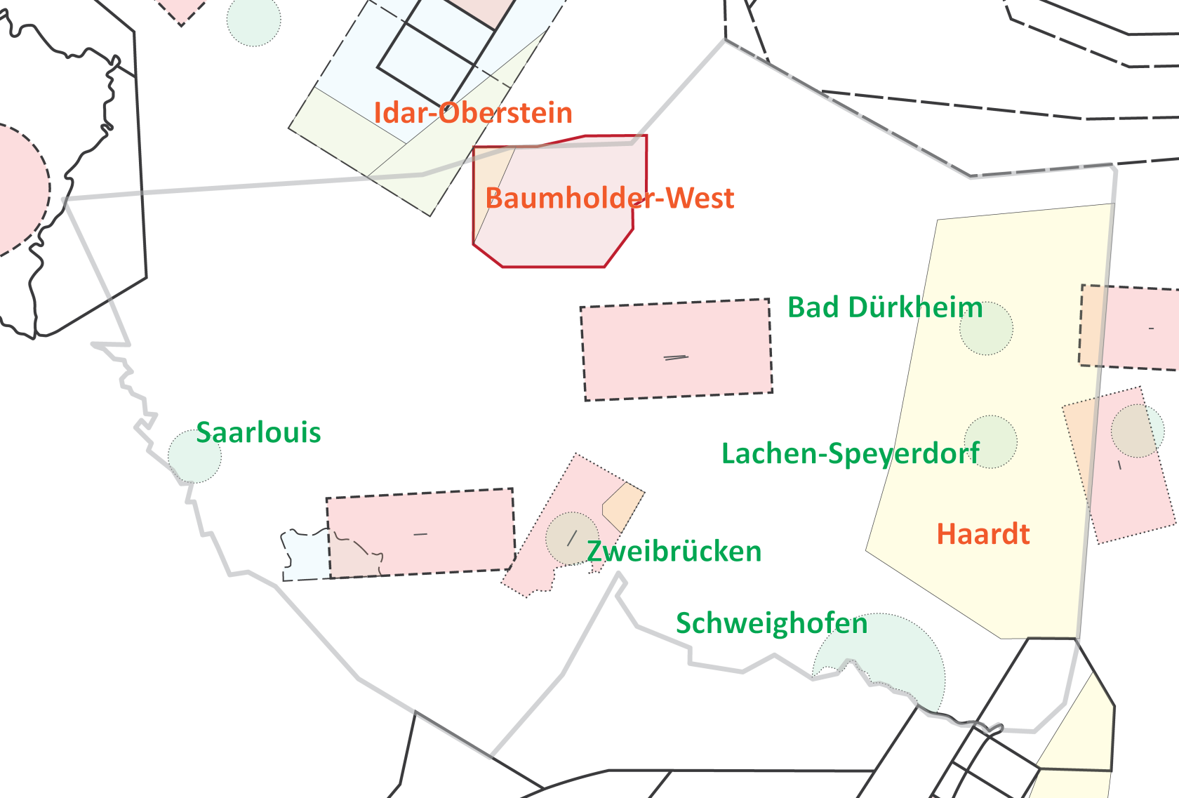A number of PJEs (parachuting drop zones) and glider sectors are located at least partially within the PFA sector. **Full radar separation** (i.e. 3 NM laterally and 1000ft vertically) has to be maintained to PJEs from approval to drop until 5 minutes after the last jumper jumped; **1 NM lateral and 500ft vertical separation** has to be maintained to glider sectors while they are active.These VFR airspaces are currently not implemented in the FIR Langen package, but included in this SOP as the related pilot procedures are publicly available to pilots.
##### PJEs| **PJE** | **Level** | **Airfield** | **Remarks** |
| **Bad Dürkheim** | GND - FL100 | EDRF | managed primarily by PFA, but requires approval by NKRL due to airspace |
| **Lachen-Speyerdorf** | EDRL | managed primarily by PFA, but requires approval by NKRL due to airspace | |
| **Saarlouis** | EDRJ | -- | |
| **Schweighofen** | EDRO | managed primarily by PFA, but requires approval by STG due to airspace | |
| **Zweibrücken** | EDRZ | -- |
| **Sector** | **Min./Max. level** | **Remarks** |
| **Local sectors** | ||
| Local sectors are only available for specific airfields and activation can only be requested by the respective airfield operator. Pilots are required to monitor that airfield's frequency to stay informed about any changes to the status of the respective sector. | ||
| **Baumholder-West** | 1500ft - FL95 | managed primarily by PFA, but requires approval by EIF due to airspace associated airfield: Idar-Oberstein (EDRG) |
| **Idar-Oberstein** | 4500ft - FL75 | managed primarily by EIF, but requires approval by PFA due to airspace associated airfield: Idar-Oberstein (EDRG) |
| **Wave gliding sectors** | ||
| Activation of wave gliding sectors can be requested by any pilot through Langen Information. Pilots are required to monitor the applicable FIS frequency to stay informed about any changes to the status of the respective sector. | ||
| **Haardt** | FL100 - FL195 | managed primarily by PFA, but requires approval by STG due to airspace |