# Overview
Geilenkirchen is a NATO base in Geilenkirchen. The airfield was originally built and used by British occupation forces after World War II and later handed over to the German Luftwaffe for a short time before becoming a NATO headquarter and the most important AWACS base in Europe. In addition to the military operations, the aeroclub Geilenkirchen conducts civilian general aviation flights at the airport, albeit primarily outside of the military operating hours.
As Geilenkirchen is a military airport, charts can't be found in the normal AIP. They are accessible through the MIL AIP, GEMIL FLIP VAD, and CENOR FLIP in the [milais](https://www.milais.org/publications.php "MILAIS Publications").
**Geilenkirchen is an unrestricted airport**. The Tower position can be staffed by all controllers with an **S2** rating or higher. The radar position can be staffed by all controllers with an **S3** rating or higher, although it is **recommended to hold the EDDL\_APP Tier 1 endorsement** for familiarity with the surrounding airspace. Additionally, controllers should closely familiarize themselves with military procedures before staffing the airport.
### Geilenkirchen ATC Stations
| **Station**
| **Station ID**
| **Login**
| **Frequency**
| **Remarks**
| **Endorsement**
|
| **ATIS**
| ATNG
| ETNG\_ATIS
| 118.090
| --
| --
|
| **Tower**
| TNGT
| ETNG\_TWR
| 120.055
| military station
| unrestricted: no course
|
| **Arrival**
| TNGA
| ETNG\_APP
| 123.730
| military station
| unrestricted: no course |
| Bottrop sector
| BOT
| EDDL\_BOT\_APP
| 119.110
| --
| Tier 1: [EDDL\_APP](https://core.vateud.net/my/endorsements "Your endorsements (VATEUD Core)") |
All stations at Geilenkirchen use the **callsign "Frisbee"**, e.g. "Frisbee Radar".
### Quickview
[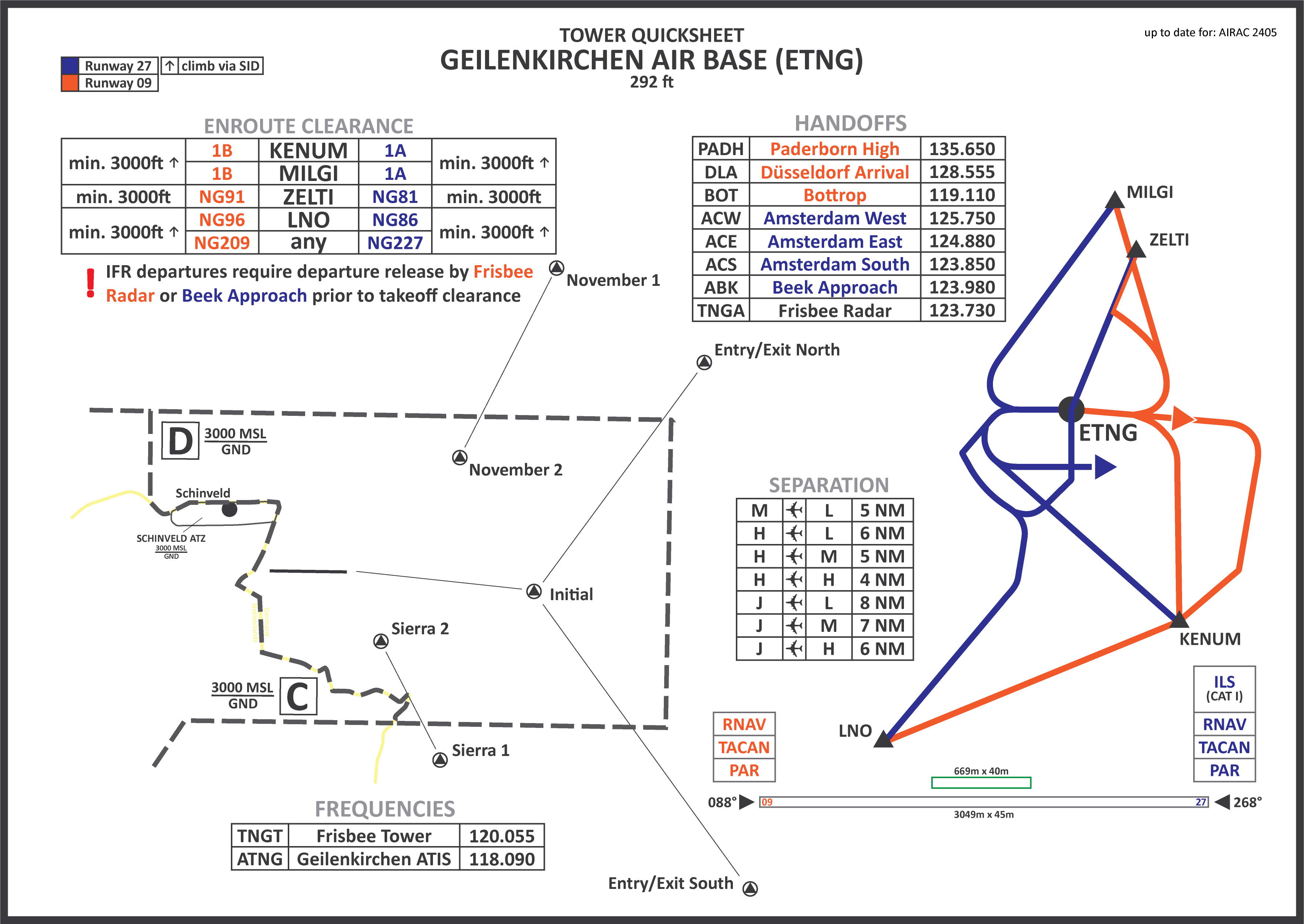](https://dms.vatsim-germany.org/s/ytis2RXLLSKDWTz "ETNG Quicksheet (VATGER DMS)")
*click on the image to open the printable quicksheet*