Military Radar
Reference Documentation
Charts and Maps for German Military airfield and Airspace can be found on the Mil AIP (www.milais.org)
Airspace
Currently, our SOPs contain little knowledge to military sectors. Therefore, this guide will describe the general concept of military Radar airspaces.
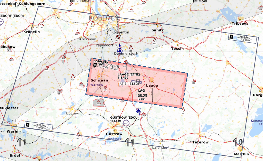 Rostrock/Lage Airport - © openflightmaps.org
We will start with Rostock Laage. As you can see, the airport has a D-CTR just like all other airports in Germany. Additionally, the airport has a lowered airspace E around the CTR. Almost all military airports have that. The horizontal boundary of the area of responsibility of the Radar coincides with the lowered E airspace. The horizontal boundary is 5500ft. Below 5500 ft and inside that lowered E, the radar controller is responsible for the IFR traffic. As always in airspace E, VFR may enter the airspace without contacting ATC.
Two more examples of this are Diepholz and Wittmund. Just like in the previous example, the vertical limit of the area of responsibility of the military Radar is 5500ft. The horizontal limit coincides with the lowered airspace E. In case of Wittmundhafen, the area of responsibility is the inner rectangle of the TMZ. With this knowledge you can estimate how big the area of responsibility of any military radar is. The upper limit is 5500ft in most cases. The actual area of responsibility can be found in the military AIP (MILAIP, AD2, Minimum vectoring altitude/Area of responsibility chart for each airport).
General Controlling
In general the military Radar has the same responsibility as a typical APP controller. However, you have to remember that you are working with high performance military aircraft and possibly VFR aircraft that call for FIS. In this case you should not rely on visual separation alone as the closing speeds of a 300kt military jet and a 80kt VFR aircraft is too great to simply ignore. In this case working with vertical separation is the easiest solution.
In general military Radars seldom work with procedures. They mostly use headings and altitudes. Speeds are also avoided. VFR and IFR departures are possible. If the pilot departs IFR, he will be handed over to the responsible DFS controller fairly early due to the low airspace boundary. If the pilot departs VFR, he has to follow the VFR departure route which can be found in the Military AIP (VAD). Every deviation from the departure route has to be requested by the pilot and approved by ATC ("request to leave CTR on top").
If the aircraft is arriving IFR, it will be handed over from Center descending FL70 and as early as possible. The aircraft should be released for descent by Center before handoff to allow the Radar controller to control the aircraft. The pilot may decide if he prefers to land VFR or IFR. VFR the arrival is done on TWR frequency as published in the VAD charts (overhead approach maneuver as described below). Sequencing is then done using traffic infos and by telling the pilot which number he is in the sequence.
| Station | Example Flight with IFR Cancellation on entry |
| GAF123 | ETNL_APP, GAF123, 5000ft |
| ETNL_APP | GAF123, ETNT_APP identified, weather code BLU, runway 27, QNH1013 |
| GAF123 | GAF123 blue, runway 27, QNH1013 cancelling IFR |
| ETNL_APP | GAF123, IFR cancelled at 45z, proceed to Entry South 27 |
| GAF123 | GAF123, IFR cancelled at 45z, proceed to Entry South 27 |
| ETNL_APP | GAF123, contact ETNT_TWR 118.425 |
| GAF123 | GAF123, contact ETNT_TWR 118.425 |
| On TWR frequency | |
| GAF123 | ETNL_TWR, GAF123, proceeding to entry south |
| ETNL_TWR | GAF123, ETNL_TWR, enter CTR via Entry South 27 |
| GAF123 | GAF123, enter CTR via Entry South 27 |
| Over Entry South | |
| GAF123 | GAF123, Entry South 27, 1700ft |
| ETNL_TWR | GAF123, ETNT_TWR Roger, report initial, number 2 following EUFI on downwind 27 |
| GAF123 | GAF123, wilco |
If VFR arrivals aren't possible then the military jet will be vectored to procedure and it will fly a PAR, ILS, TACAN, NDB or RNAV approach but without the procedures as described below.
Lastly, we will discuss IFR pickups. IFR pickups are mainly used for military aircraft that enter the area of responsibility of the Radar controller with the intention to land IFR. Departing traffic to leave will already receive the clearance on ground. IFR pickups for military aircraft are much simpler than what you usually do for civil aviation. You just have to make sure that the jet is above the MVA, that it has been assigned a HDG and an altitude (or you have assign either or both during the IFR pickup) and then you say "IFR starts now" and that's it. You should also include the clearance limit (e.g. "cleared to Schleswig") but that is often left out in real life. If you give a IFR pickup for an aircraft that is leaving your sector, you need to coordinate an actual IFR clearance with the DFS station. However, if necessary you can start IFR immediately (mind the MVA) and coordinate the clearance with the DFS station later.
Departures
Unrestricted Climb
An unrestricted climb may be authorized for such reasons as noise abatement, fuel conservation, reduction of icing, or elimination of traffic conflicts. An unrestricted climb is authorized to climb directly to a cruise/enroute altitude without an interim stop. Unrestricted climbs leading outside of the AOR of the Approch controler need to be coordinated withe neighboring sectors.
Instrument Approaches/Procedures
In general military airfields tend to have a mix of ILS, NDM (DME), TACAN (DME) and RNAV approaches. However, most do not have an ILS. Instead the Precision Approach Radar (PAR) is used as a precision approach. However, that is not an instrument approach and thus will be explained in a later chapter.
As mentioned before, instrument approaches are mainly used without the procedure. Most military procedures include a DME Arc and then the familiar final approach. The waypoints on the procedure usually don't have a name so if you want to clear someone to fly the approach via the procedure, it's best to use the terms "Initial Approach Fix" (e.g. "out of IAF cleared TACAN rwy 27") or in general just explain to the pilot what you want him to do (e.g. "Join 12 DME Arc of TACAN rwy 27, cleared TACAN approach runway 27"). That is not quite the way they do it in real life but it will probably work well enough on Vatsim.
In general though it is enough to vector the aircraft to the final approach track and clear them for the approach. Remember that these are non precision approaches so the intercept must be done before the FAF and on the published altitude. You should also make sure that the aircraft has 2NM of straight and level flight before initiating the descent.
Ground Controled Aproches
A ground-controlled approach (GCA) is a service provided by air-traffic controllers to guide aircraft safely during landings, especially in adverse weather conditions. It relies on primary radar images. There are two main types:
- Surveillance Radar Approach (SRA): Offers non-precision surveillance radar approaches without glidepath guidance
- Precision Approach Radar (PAR): Provides both vertical and horizontal guidance for precise landings.
In Germany the GCA Position is known as "Precision", only in Ramstein and Spangdahlem they are called by GCA.
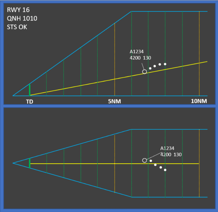
Surveillance Radar Approach (SRA)
In this approach the pilot is provided with instructions and information on the aircraft's location relative to the extended centerline and distance from touchdown. During this approach there should be only one aircraft on frequency. If you ever need to give an SRA during operations with multiple approach controllers, you can let the feeder handle the SRA while the arrival controller handles all other traffic as usual.
In general the procedure for the controller is:
- The pilot needs to be told when the SRA terminates before beginning the descend and the OCA ("This will be a SRA approach, runway 25 terminating at the missed approach point, OCA 840ft, check your minima")
- The final turn onto the runway heading should not be more than 30° and there should be sufficient time before the start of the descent
- The pilot needs to be warned prior to descent ("11NM from T/D, 1NM prior to descend")
- The pilot does not read back the altitudes. He only confirms with his callsign.
- The pilot needs to be told when to initiate the descent ("10NM from T/D, commence final descent now")
- The pilot needs to be informed about the altitude each mile ("7NM from T/D, altitude should be 2500 feet")
- The pilot needs to receive heading adjustments when necessary or otherwise be told that the heading looks good ("left heading 245" or "heading is good"). Heading adjustmens by 1 degree should be avoided.
- At 4NM the pilot needs to be reminded to check gear down ("4NM from T/D, altitude should be 1600ft, remember OCA 840ft, check gear down locked")
- From 4NM to T/D transmissions should not be interrupted by more than 5 seconds.
- The pilot needs to be reminded one mile before approaching OCA ("2NM from T/D, altitude should be 1000ft, approaching OCA, report field in sight")
- Between 2NM and T/D altitude and heading instructions should be given each 1/2 NM.
- If pilot reports field in sight he can be transferred to TWR or can be given the landing clearance after coordination between APP and TWR
- If the pilot does not report the field in sight, ATC should remind him to go around or continue visually ("passing MAP, continue visually or go around" or "go around, follow published missed approach procedure")
Precision Approach Radar (PAR)
The PAR is very similar to the SRA but with better radar equipment to provide precise guidance. That's why it is considered a precision approach. If you have the ground radar plugin and its approach path function available for your airport, you can provide more accurate guidance to undertake such an approach.
The main different to the SRA is that the controller does not stop talking so there is no time for the pilot to confirm any instruction. ATC continues talking until the threshhold of the runway.
If you want to get an idea watch this video.
You will notice in this video that in addition to heading instructions, ATC also gives information about the position of the aircraft in relation to centerline ("right of centerline", "correcting" etc.) and glide path ("below glide path" etc.) while in the SRA ATC only gives headings and recommends an altitude.
Precision Radar Screen
Special Activities
Alert aircraft (QRA).
Once the QRA aircraft are (is) airborne, they have the highest priority and their course must be cleaned horizontally and vertically. The handover to the GCI controller must be coordinated at the earliest in order to facilitate the interception.
Simulated Flameout (SFO) and Emergency Landing Pattern (ELP)
At locations where SFO/ELP maneuvers are conducted, the facility air traffic manager must issue a letter of agreement with the appropriate military authority and adjacent facilities as required. The letter of agreement must include at least the following issues:
- A complete description of the SFO/ELP procedure. (High-key altitude MSL, airspeed during procedure, direction of turns, and low-key altitude MSL will be obtained from the military for all types of aircraft planning to utilize this procedure. The SFO/ELP maneuvering airspace area should be visible from the normal local control position in the control tower.)
- The weather conditions that must exist before issuance of approval by the tower. (Ceiling must be at least 1,000 feet above the approved high-key altitude, and flight and ground visibility must be reported to be at least 5 miles.)
- A statement to the effect that a practice SFO/ELP may be disapproved because of traffic or other reasons either before or after the start of the maneuver.
- A statement that a practice SFO/ELP will be approved only between sunrise and sunset.
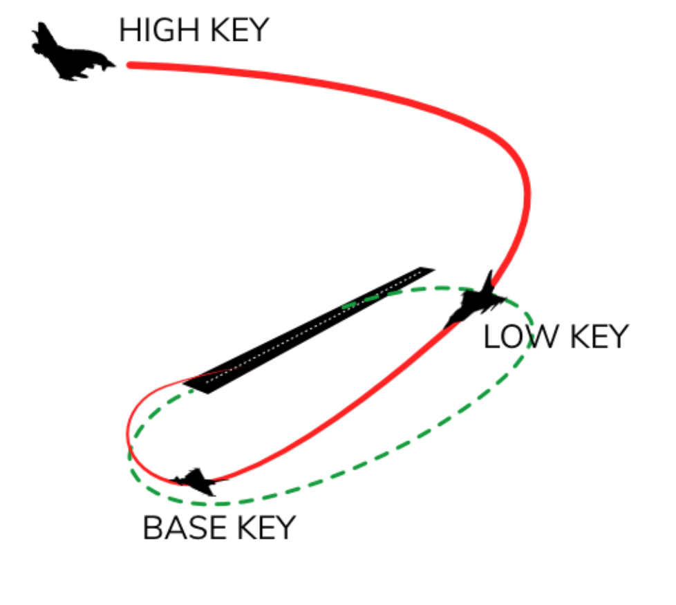
The peculiarity of this procedure is that the aircraft has the engine at IDLE and descends with a very high vertical speed and because of that, once authorized and started it should NOT be interrupted.
During this phase, the controller must regulate all traffic according to the current simulated shutdown procedure, ensuring that its trajectory remains clear at all times.