Tower
Sylt Tower is responsible for all arriving and departing traffic. The top level of the airspace D control zone is 2600ft MSL. Above this altitude and around the CTR airspace E covers the area within responsibility of Bremen Radar (EDWW_EID_CTR, usually covered by EDWW_ALR_CTR, EDWW_HEI_CTR or EDWW_W_CTR). Different DangerZones (ED-D) from Germany and Denmark are around and above the Airport, as well as a Para jumping Area up to FL100 directly above the airport with a landing area north of the field.
 Controlzone and VFR Reporting Points of Sylt Airport - © openflightmaps.org
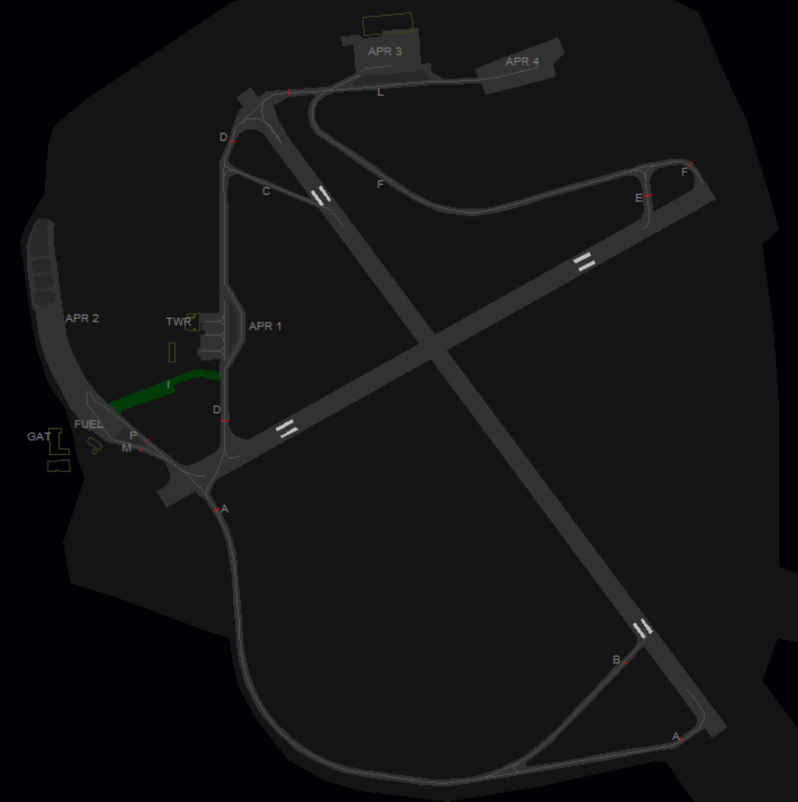
Runway and Airport
Sylt Airport has two crossing runways, 32/14 with 6955ft (2120m) and 06/24 5564ft (1696m). A Glider strip is located south-east of the runway cross. The main runway 14/32 is certified for RNP approaches on both sides and ILS CAT 1 on runway 32.
The airport features three apron areas. GAT west, mixed traffic north and the commercial apron in the center.
Runway 14/32
Some old sceneries still have taxiway G in the east of the field. It is advised at 14 landings to add the phrase "vacate to the right".
Runway 06/24
Restricted to aircrafts up to 20 tons MTOW between threshold 24 and intersecting runway 14/32.
In reality only 7 tons MTOW are allowed without coordination. Heavier aircraft up to 20 tons PPR only (prior permission required). As we do not simulate rescue and firefighting categories and local security regulations, the 20 tons MTOW can be applied anytime.
Departures
All IFR Departures need a Departure-Release from Bremen Radar! *
Coordinate early enough on TeamSpeak, as you might get a delay time, because of arriving traffic over OLDIP.
* If traffic permits, Radar can always give a "general departure release until further notice". In that case the tower doesn't need to ask for each departure separately.
Spacing: Departures shall be separated with a minimum of 5 nm or wake turbulence separated, whichever is greater, because there is only one useable SID per runway config.
Auto-Handoff: Pilots shall contact Bremen Radar immediately after take-off without a specific handoff.
Arrivals
Unless a pilot request a specific location (e.g. facilities north-east), they should get a taxi instruction leading to the commercial Apron1 or general aviation Apron 2. For landing traffic 14/32, runway 06/24 can be used as taxiway as well.
VFR
Sylt offers 5 routes in and out of the CTR at max. 2000ft. All VFR Waypoints are mandatory reporting points.
| VRP | N | H | S1 | E1 | L |
|---|---|---|---|---|---|
| NAV | North-West of the Island | South-West of the Island | South, east of Hönum | East, Trainline Intersection to the Island | North, East of List |
Overflying of build-up areas in the vicinity of the airport should be avoided. For this to comply, traffic circuits should be issued in the east of the field.
Helicopters
Helipad: There are no specific Helipads but pilots should expect Taxiway I (grass strip between Tower and Apron2/GAT) for landing. Otherwise on Tower discretion. The parking area is usually on the grass between Apron1 and Apron 2
Ground
Parking
Airliner Stands: Apron 1 has three airliner stands in front of the passenger terminal
Business Jets: Apron 2
General Aviation: Apron 2 in the west of the field
Helicopters: Gras area between Apron1 and Apron 2 behind the Tower or Apron 2
Glider School: Southeast of the field (opposite east of threshold runway 34) with own parking area next to the Glider Strip.
Apron 3 + Apron 4: additional aprons, private hangars
Parking at the fuel stations is strictly forbidden.
Taxiways
Hotspot zone at taxiway M and P at holding point runway 06. M is used for outgoing and P for incoming traffic.
Taxiway B available up to 5.7 tons MTOW only.
Taxiway I is a grass strip and can be used for aircrafts up to 2 tons MTOW (echo class),
Note: not available in all sceneries, better use runway 06/24 to connect Apron 2 with taxiway D.
Delivery
VATSIM has the Top-Down principle, therefore IFR Clearances shall be given by the tower, contrary to real-life procedures, where these are given by Bremen Radar. Delivery Service is responsible for all departing flights under IFR.
Initial climb clearance: The initial climb clearance at Sylt Airport is 4000ft on all published departure procedures. The altitude shall be entered as cleared altitude (CFL) in an appropriate list or tag.
SIDs
| SID | 14 | 32 | Climb |
|---|---|---|---|
| OLDIP | 1A (via SID) | 1B (via SID) | 4000ft |
Specials
Vectored departures: The use of vectored departures requires prior coordination with the responsible radar station. An initial altitude to climb shall be provided.
IFR local flights: IFR local flights are coordinated with the responsible radar controller, who may instruct a different departure procedure, possibly vectored departures.
Low Visibility Operations
At Sylt, no approaches are certified during low-visibility operations. Departures are allowed to take off if the following minima are met:
| Runway | Takeoff Minima | Condition |
|
14/32 |
400 m RVR | During Day |
| 800 m RVR | During Night |