Tower
Lübeck Tower is responsible for all arriving and departing traffic. The top level of the airspace D control zone is 2000ft MSL. Above this altitude and around the CTR airspace E covers the area within responsibility of Bremen Radar (Hamburg Approach). South-East of the field is a nature reserve area (Schaalsee), which shall be avoided below 2000ft.
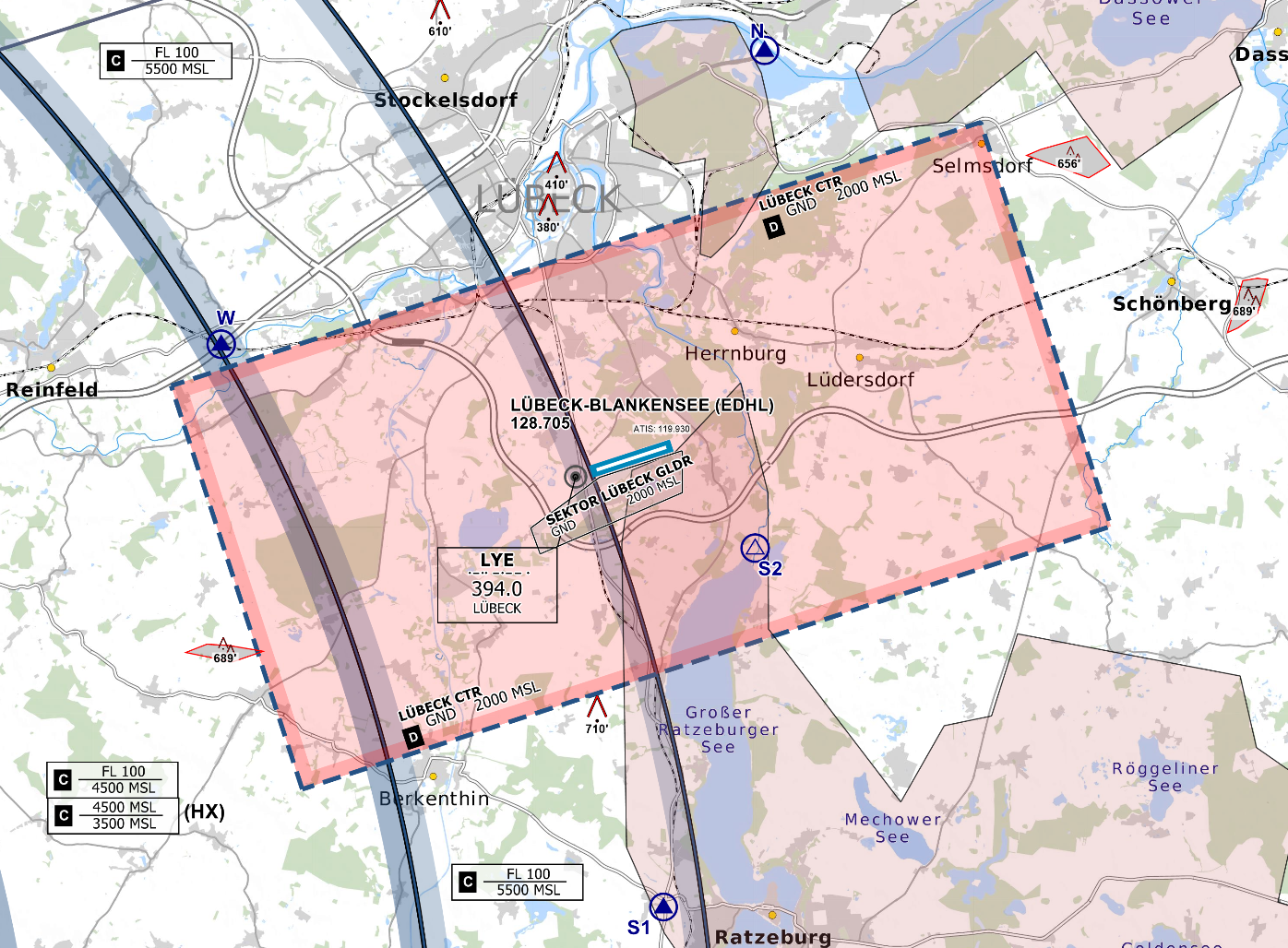
Controlzone and VFR Reporting Points of Lübeck Airport - © openflightmaps.org
Runway and Airport
Lübeck Airport has a 6896ft (2102m) long single runway (07 / 25) with Low-Visibility CAT II equipment on 07, as well as a grass glider strip south of the main runway. The runway configuration is not dependent on EDDH but should always be considered and coordinated with Bremen Radar (Hamburg Approach).
The Airport features a small terminal building with check-in facilities, a shop and some restaurants. The apron has three stands, which are suitable for Class C aircrafts such as the Airbus A320, as well as some stands for smaller general aviation aircraft.
Departures
All IFR Departures need a Departure-Release from Bremen Radar! *
Coordinate early enough on TeamSpeak, as Bremen Radar might restrict the initial climb clearance and departures times due to workload and traffic situation.
* If traffic permits, Radar can give a "general departure release until further notice". In that case the tower doesn't need to ask for each departure separately.
Spacing: Departures shall be separated with a minimum of 3 nm or wake turbulence separated, whichever is greater. When two aircrafts have the same SID waypoint the separation shall be increased to 5 nm or wake turbulence separation whichever is greater.
Auto-Handoff: Pilots shall contact Bremen Radar immediately after take-off without a specific handoff.
VFR
Lübeck Airport has four routes in and out of the CTR. Except S2, all other visual reporting points are mandatory.
| VRP | NOVEMBER | SIERRA (1+2) | LIMA | WHISKEY |
|---|---|---|---|---|
| NAV | Lübeck Harbor | Leading to Ratzeburg, west of the Ratzeburger Lake | Elbe-Lübeck Canal between Berkenthin and Mölln | Highway A1 west of Lübeck |
There are no distinct VFR procedures but it is common practice to use the two reporting points in active runway direction for departures and the two reporting points from behind the runway for arrivals.
Helicopters
Helipad: Lübeck Airport has no Helipads. Helicopters use the runway for all operations and can park at a designated parking area between Hangar E and G, north of the GA Apron. All Helicopters air-taxi to the runway.
Police and Rescue helicopters: Helicopter operations are likely in the vicinity of Hamburg and Lübeck City. Two medical Helicopter Pads are located north of the field inside the CTR.
Low Visibility Operations (LVO)
Whenever low visibility conditions exist, runway 07 should be used as the runway in use. Wind conditions shall be disregarded.
During Low Visibility Operations at Lübeck, only runway 07 can be used for arriving traffic, as this runway is equipped with an ILS approach up to CAT II.
Departing traffic may use both runway directions under the condition that the minimum takeoff RVR is met:
| Runway | Takeoff Minima | Condition |
|
07 |
125 m RVR | --- |
|
25 |
400 m RVR | --- |
If the RVR is not below 400 m, departing traffic may request runway 25 due to performance reasons. In this case, close coordination with Bremen Radar is required before issuing the line-up clearance, as arriving traffic will still use runway 07 for landing.
During Low Visibility Operations, Taxiway A shall be used for departing and arriving traffic exclusively. Arriving traffic needs to perform a backtrack in this case. Close coordination with Apron is required to avoid nose-to-nose situations on taxiway A.
When the weather condition requires low visibility operations the use shall be announced in the ATIS.
use &lvp in the ATIS maker URL
During low visibility operations, the departure and arrival spacing is increased. Delays may be issued earlier than in normal conditions.