VFR Traffic
We ask all pilots to also read the General section with information relevant to all pilots.
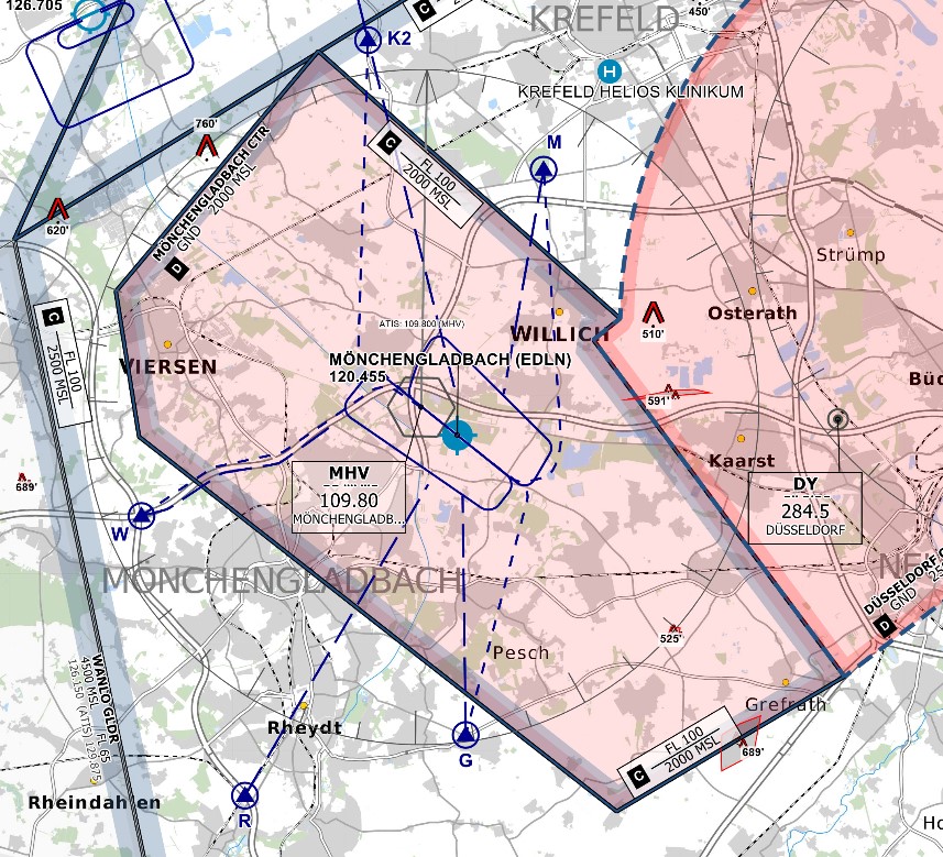
Mönchengladbach’s airspace and general traffic levels make the airport very friendly to VFR traffic in the real world. As this is similar on VATSIM, controllers will usually be able to accommodate VFR requests. However, pilots should keep the airport's location within the Köln/Düsseldorf TMA, Germany's most complex airspace, as well as its direct border to the Düsseldorf CTR in mind.
Airspace Structure
CTR
The Mönchengladbach CTR has a top altitude of 2000 ft MSL, about 1800 ft AGL. Please pay close attention to setting the correct QNH and your altitude to avoid inadvertently entering airspace C above.
The following mandatory reporting points exist around the airport:
| Reporting point |
Use |
Location |
| G |
Entry/Exit from/to the S | industrial district Giesenkirchen-Nord |
| K1 |
Entry/Exit from/to the N on K route |
quarry lake Kempen |
| K2 |
Entry/Exit from/to the N on K route |
roundabout NW of St. Tönis |
| M |
Entry/Exit from/to the NE | DHL distribution center Krefeld |
| R |
Entry from the SW |
highway A61 exit Wickrath |
| W |
Entry/Exit from/to the W |
highway intersection A52/A61 |
Keep in mind that ATC might instruct you to use a different reporting point than the one you requested, if necessary.
Departure & Arrival
The maximum altitude for all departures and arrivals is 2000 ft AMSL.
Traffic circuit
Mönchengladbach has a recommended (albeit not mandatory) traffic circuit in the North and in the South. Pilots should follow these circuits whenever no contrary instruction has been given by ATC. More information can be found on the airport's website. The Northern circuit is at an altitude of 1200ft AMSL, the Southern circuit is at an altitude of 1100ft AMSL.